EPAC: CRISTINA - Post-Tropical

Moderator: S2k Moderators

Message
Author
User avatar
euro6208
Category 5
Category 5
Posts: 18547
Joined: Mon Mar 08, 2004 7:50 pm
Location: Guam

Re: EPAC: CRISTINA - Hurricane

#261 Postby euro6208 » Thu Jun 12, 2014 8:22 am

xtyphooncyclonex wrote:
euro6208 wrote:03E CRISTINA 140612 1200 16.4N 106.8W EPAC 125 940

12Z update in. Cristina at 125 knots!

Cristina was a upgraded to a category 4 with 125 kt winds about 30 minutes ago by the NHC.


Well the best track/ATCR is a confirmation of the intensity given by NHC...
0 likes   
Remember, all of my post aren't official. For official warnings and discussions, Please refer to your local NWS products...

NWS for the Western Pacific

https://www.weather.gov/gum/

Ntxw
Storm2k Moderator
Storm2k Moderator
Posts: 21565
Joined: Wed Oct 21, 2009 6:34 pm
Location: DFW, Texas

Re: EPAC: CRISTINA - Hurricane

#262 Postby Ntxw » Thu Jun 12, 2014 8:31 am

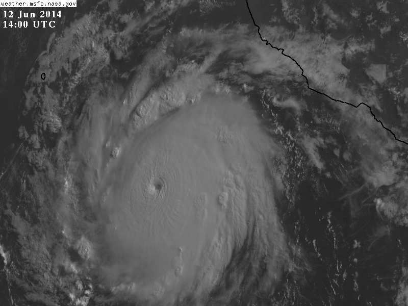
Visible finally showing

Image
0 likes   
The above post and any post by Ntxw is NOT an official forecast and should not be used as such. It is just the opinion of the poster and may or may not be backed by sound meteorological data. It is NOT endorsed by any professional institution including Storm2k. For official information, please refer to NWS products.

  Help support Storm2K!
Help Support Storm2K

User avatar
euro6208
Category 5
Category 5
Posts: 18547
Joined: Mon Mar 08, 2004 7:50 pm
Location: Guam

Re: EPAC: CRISTINA - Hurricane

#263 Postby euro6208 » Thu Jun 12, 2014 8:32 am

Absolutely beautiful at the same time deadly!
0 likes   
Remember, all of my post aren't official. For official warnings and discussions, Please refer to your local NWS products...

NWS for the Western Pacific

https://www.weather.gov/gum/

User avatar
euro6208
Category 5
Category 5
Posts: 18547
Joined: Mon Mar 08, 2004 7:50 pm
Location: Guam

Re: EPAC: CRISTINA - Hurricane

#264 Postby euro6208 » Thu Jun 12, 2014 8:35 am

ADT now at 6.7 = 132.2.knots...

Raw T/Adjusted up to 7.0 = 140 knots!
0 likes   
Remember, all of my post aren't official. For official warnings and discussions, Please refer to your local NWS products...

NWS for the Western Pacific

https://www.weather.gov/gum/

CrazyC83
Professional-Met
Professional-Met
Posts: 33398
Joined: Tue Mar 07, 2006 11:57 pm
Location: Deep South, for the first time!

#265 Postby CrazyC83 » Thu Jun 12, 2014 8:37 am

Cat 5 soon perhaps?

Amazing the second storm to do this...and it is only June 12!!
0 likes   

User avatar
Yellow Evan
Professional-Met
Professional-Met
Posts: 15960
Age: 25
Joined: Fri Jul 15, 2011 12:48 pm
Location: Henderson, Nevada/Honolulu, HI
Contact:

Re: EPAC: CRISTINA - Hurricane

#266 Postby Yellow Evan » Thu Jun 12, 2014 8:38 am

euro6208 wrote:Absolutely beautiful at the same time deadly!


some big waves likely in MX and CA. Also, could approach Soccoro Island, but will be weakening by that time.
0 likes   

stormcruisin

#267 Postby stormcruisin » Thu Jun 12, 2014 8:40 am

This looks to me it may be developing a double-eye-walled structure on dvorak sat-pic.
0 likes   

User avatar
Yellow Evan
Professional-Met
Professional-Met
Posts: 15960
Age: 25
Joined: Fri Jul 15, 2011 12:48 pm
Location: Henderson, Nevada/Honolulu, HI
Contact:

Re:

#268 Postby Yellow Evan » Thu Jun 12, 2014 8:43 am

stormcruisin wrote:This looks to me it may be developing a double-eye-walled structure on dvorak sat-pic.


I'm starting to see a stadium effect actually. But you could be right and it'll start an ERC soon.
0 likes   

tolakram
Admin
Admin
Posts: 19182
Age: 60
Joined: Sun Aug 27, 2006 8:23 pm
Location: Florence, KY (name is Mark)

Re: EPAC: CRISTINA - Hurricane

#269 Postby tolakram » Thu Jun 12, 2014 8:43 am

13:30Z

Image
0 likes   
M a r k
- - - - -
Join us in chat: Storm2K Chatroom Invite. Android and IOS apps also available.

The posts in this forum are NOT official forecasts and should not be used as such. Posts are NOT endorsed by any professional institution or STORM2K.org. For official information and forecasts, please refer to NHC and NWS products.

CrazyC83
Professional-Met
Professional-Met
Posts: 33398
Joined: Tue Mar 07, 2006 11:57 pm
Location: Deep South, for the first time!

#270 Postby CrazyC83 » Thu Jun 12, 2014 8:48 am

UW - CIMSS
ADVANCED DVORAK TECHNIQUE
ADT-Version 8.2.1
Tropical Cyclone Intensity Algorithm

----- Current Analysis -----
Date : 12 JUN 2014 Time : 124500 UTC
Lat : 16:20:10 N Lon : 106:55:20 W


CI# /Pressure/ Vmax
6.7 / 933.1mb/132.2kt


Final T# Adj T# Raw T#
6.7 7.0 7.1

Estimated radius of max. wind based on IR :N/A km

Center Temp : +10.5C Cloud Region Temp : -74.0C

Scene Type : EYE

Positioning Method : RING/SPIRAL COMBINATION

Ocean Basin : EAST PACIFIC
Dvorak CI > MSLP Conversion Used : ATLANTIC

Tno/CI Rules : Constraint Limits : 1.3T/6hr
Weakening Flag : OFF
Rapid Dissipation Flag : OFF

C/K/Z MSLP Estimate Inputs :
- Average 34 knot radii : 55km
- Environmental MSLP : 1010mb

Satellite Name : GOES13
Satellite Viewing Angle : 41.1 degrees

****************************************************
0 likes   

Meow

#271 Postby Meow » Thu Jun 12, 2014 8:58 am

In my opinion, this looks more beautiful than Amanda.
0 likes   

User avatar
euro6208
Category 5
Category 5
Posts: 18547
Joined: Mon Mar 08, 2004 7:50 pm
Location: Guam

Re: EPAC: CRISTINA - Hurricane

#272 Postby euro6208 » Thu Jun 12, 2014 9:04 am

Image

Cristina at 125 knots now at 5.27 ACE! Pretty incredible!
0 likes   
Remember, all of my post aren't official. For official warnings and discussions, Please refer to your local NWS products...

NWS for the Western Pacific

https://www.weather.gov/gum/

Ntxw
Storm2k Moderator
Storm2k Moderator
Posts: 21565
Joined: Wed Oct 21, 2009 6:34 pm
Location: DFW, Texas

#273 Postby Ntxw » Thu Jun 12, 2014 9:09 am

She's very photogenic, symmetrical

http://i57.tinypic.com/2zghfsm.gif
Last edited by tolakram on Thu Jun 12, 2014 9:46 am, edited 1 time in total.
Reason: changed to link
0 likes   
The above post and any post by Ntxw is NOT an official forecast and should not be used as such. It is just the opinion of the poster and may or may not be backed by sound meteorological data. It is NOT endorsed by any professional institution including Storm2k. For official information, please refer to NWS products.


  Help support Storm2K!

Help Support Storm2K


User avatar
NDG
S2K Supporter
S2K Supporter
Posts: 14945
Joined: Sun Jul 09, 2006 10:14 pm
Location: Orlando, FL

Re: EPAC: CRISTINA - Hurricane

#274 Postby NDG » Thu Jun 12, 2014 9:22 am

Another view of her this morning.


Image
0 likes   

hurricaneCW
Category 5
Category 5
Posts: 1773
Joined: Wed Mar 03, 2010 6:20 am
Location: Toms River, NJ

Re: EPAC: CRISTINA - Hurricane

#275 Postby hurricaneCW » Thu Jun 12, 2014 9:40 am

Wow impressive, far beyond what I thought was possible. This year could be a problem for Mexico if these storms keep churning up because eventually one will not be on an OTS track. ACE will be through the roof if it isn't already so far for the EPAC.
0 likes   

User avatar
cycloneye
Admin
Admin
Posts: 139596
Age: 67
Joined: Thu Oct 10, 2002 10:54 am
Location: San Juan, Puerto Rico

Re: EPAC: CRISTINA - Hurricane

#276 Postby cycloneye » Thu Jun 12, 2014 9:45 am


HURRICANE CRISTINA DISCUSSION NUMBER 13
NWS NATIONAL HURRICANE CENTER MIAMI FL EP032014
800 AM PDT THU JUN 12 2014

Cristina has gone through an extraordinary, but not unprecedented,
phase of rapid intensification during the past 24 hours, with its
maximum winds increasing by about 65 kt since this time yesterday.
The hurricane has a circular central dense overcast with very cold
cloud tops to near -80C. Water vapor images indicate that
upper-level outflow is somewhat restricted in the southwestern
quadrant but is good elsewhere. Cristina has strengthened so fast
that TAFB and SAB satellite estimates are limited to T6.0/115 kt by
Dvorak rules. The initial intensity is set at 130 kt, a little
below the latest objective ADT estimate of T6.8/135 kt.

The intensity trend appears to have leveled off a bit, and no
further significant strengthening is expected. However, light
vertical wind shear and a deep warm ocean should allow Cristina to
maintain major hurricane strength for another 36 hours or so.
After that time, gradually increasing vertical shear and cooler sea
surface temperatures should induce significant weakening after
about 48 hours. The official intensity forecast is fairly close to
the consensus ICON and is similar to that of the special advisory.

Cristina is located to the south of a mid-level ridge centered over
northern Mexico, and the initial motion remains 295/7 kt. The
cyclone is expected to maintain a west-northwestward to
northwestward heading during the next 4 days due to the ridge, and
the track guidance is in fairly good agreement on this scenario.
The GFDL model is the primary outlier, taking Cristina farther north
after 48 hours. The official forecast sticks with the rest of the
guidance, however, and is relatively unchanged from the previous
advisory.

With Hurricanes Amanda and Cristina reaching category 4 status, this
is the first time there have been two category 4 hurricanes in June
in the eastern North Pacific basin since the beginning of the
satellite era in 1966. Prior to Cristina, the earliest second
category 4 hurricane was Hurricane Elida in 1984, which reached
that threshold on July 1.

FORECAST POSITIONS AND MAX WINDS

INIT 12/1500Z 16.6N 107.1W 130 KT 150 MPH
12H 13/0000Z 17.2N 108.2W 130 KT 150 MPH
24H 13/1200Z 17.9N 109.5W 115 KT 135 MPH
36H 14/0000Z 18.7N 110.7W 100 KT 115 MPH
48H 14/1200Z 19.2N 111.7W 85 KT 100 MPH
72H 15/1200Z 19.7N 113.1W 65 KT 75 MPH
96H 16/1200Z 20.0N 114.5W 45 KT 50 MPH
120H 17/1200Z 20.0N 117.0W 30 KT 35 MPH...POST-TROP/REMNT LOW

$$
Forecaster Berg
0 likes   
Visit the Caribbean-Central America Weather Thread where you can find at first post web cams,radars
and observations from Caribbean basin members Click Here

User avatar
Macrocane
Category 5
Category 5
Posts: 4218
Age: 35
Joined: Sun May 24, 2009 5:35 pm
Location: El Salvador

Re: EPAC: CRISTINA - Hurricane

#277 Postby Macrocane » Thu Jun 12, 2014 9:48 am

Simply beautiful. I know the Atlantic is people's favorite but personally I love to track storms in both EPAC and WPAC.
0 likes   

Meow

Re: EPAC: CRISTINA - Hurricane

#278 Postby Meow » Thu Jun 12, 2014 9:50 am

cycloneye wrote:FORECAST POSITIONS AND MAX WINDS

INIT 12/1500Z 16.6N 107.1W 130 KT 150 MPH
12H 13/0000Z 17.2N 108.2W 130 KT 150 MPH
24H 13/1200Z 17.9N 109.5W 115 KT 135 MPH
36H 14/0000Z 18.7N 110.7W 100 KT 115 MPH
48H 14/1200Z 19.2N 111.7W 85 KT 100 MPH
72H 15/1200Z 19.7N 113.1W 65 KT 75 MPH
96H 16/1200Z 20.0N 114.5W 45 KT 50 MPH
120H 17/1200Z 20.0N 117.0W 30 KT 35 MPH...POST-TROP/REMNT LOW

$$
Forecaster Berg
[/b]

Only 5 knots behind Amanda... Cristina still has chances to surpass.
0 likes   

User avatar
SouthDadeFish
Professional-Met
Professional-Met
Posts: 2835
Joined: Thu Sep 23, 2010 2:54 pm
Location: Miami, FL
Contact:

#279 Postby SouthDadeFish » Thu Jun 12, 2014 10:00 am

Amanda and Cristina are really going to hurt the NHC's intensity forecast verification...

It has been a very impressive run over the past 48 hours or so. If you use a 30 knot increase in 24 hours to classify RI, Cristina actually has continued to RI since June 10 at 9Z, from a 35 knot TS until now.

June 10, 9Z: 35 knots
June 11, 9Z: 65 knots
June 12, 9Z: 105 knots
June 12, 15Z: 130 knots

Wow. And to think the first forecast for Cristina had her maxing out at 70 knots. Just goes to show hard it is to accurately forecast intensity and why we still have so much to learn.
0 likes   

User avatar
Kingarabian
S2K Supporter
S2K Supporter
Posts: 15461
Joined: Sat Aug 08, 2009 3:06 am
Location: Honolulu, Hawaii

#280 Postby Kingarabian » Thu Jun 12, 2014 10:21 am

Final ADT numbers are at Cat.5.


CI# /Pressure/ Vmax
6.9 / 928.2mb/137.4kt
Final T# Adj T# Raw T#
6.9 6.8 6.8
0 likes   
RIP Kobe Bryant


Return to “2014”

Who is online

Users browsing this forum: No registered users and 11 guests