ATL: ARTHUR - Post-Tropical - Discussion

Moderator: S2k Moderators

Message
Author
ozonepete
Professional-Met
Professional-Met
Posts: 4743
Joined: Mon Sep 07, 2009 3:23 pm
Location: From Ozone Park, NYC / Now in Brooklyn, NY

Re:

#201 Postby ozonepete » Sun Jun 29, 2014 10:12 pm

Hammy wrote:Convection is weakening and moving away from the LLC pretty quickly. It's looking doubtful with this that the recon will go out tomorrow, and another day after that given the motion and it will probably be onshore.


Hi Hammy!
It's a long way til tomorrow, lol. And there's no indication of much westward motion at all right now either at mid or low levels. the only way it goes over Florida is if it doesn't deepen: stay tuned. :)
0 likes   

TheStormExpert

Re: ATL: INVEST 91L - Discussion

#202 Postby TheStormExpert » Sun Jun 29, 2014 10:14 pm

Aric Dunn wrote:
SFLcane wrote:
ozonepete wrote:Still dropping south - more than I thought it would.


indeed..could be at sfl latitude if it keeps droping. In terms of models system not well established to get a good handle on it.


dont be fooled but the convection out running the circ.. its east of daytona.

:darrow: Yep it's well East of Daytona Bach, FL. With the Anti-Cyclone a little ways to the SW just north of Grand Bahama.
Image
Image
Image
0 likes   

Alyono
Professional-Met
Professional-Met
Posts: 6961
Joined: Fri Apr 26, 2013 3:52 pm
Location: Texas Coast

#203 Postby Alyono » Sun Jun 29, 2014 10:15 pm

A stronger system would head further south as the deeper layer mean has more of a southerly component

The developments tonight have me questioning my forecast of development. Would have liked to have seen some organization this evening. Perhaps the GFS/CMC will get one right
0 likes   

User avatar
cycloneye
Admin
Admin
Posts: 145295
Age: 68
Joined: Thu Oct 10, 2002 10:54 am
Location: San Juan, Puerto Rico

Re: ATL: INVEST 91L - Discussion

#204 Postby cycloneye » Sun Jun 29, 2014 10:16 pm

For those who may not know,there will not be a recon mission as planned for the morning hours.That mission was moved to the afternoon.Learn more at the Recon Thread.
0 likes   
Visit the Caribbean-Central America Weather Thread where you can find at first post web cams,radars
and observations from Caribbean basin members Click Here

TheStormExpert

Re:

#205 Postby TheStormExpert » Sun Jun 29, 2014 10:17 pm

Alyono wrote:This has actually become less organized throughout the day

As I said yesterday, conditions were hostile and they likely will remain hostile for 24 more hours

At the 2pm TWO the NHC mentioned conditions would not improve until late Tuesday, now as of 8pm they mention them improving within the next few days.
0 likes   

ozonepete
Professional-Met
Professional-Met
Posts: 4743
Joined: Mon Sep 07, 2009 3:23 pm
Location: From Ozone Park, NYC / Now in Brooklyn, NY

Re: ATL: INVEST 91L - Discussion

#206 Postby ozonepete » Sun Jun 29, 2014 10:17 pm

It's when it stalls out that things will get interesting. That isn't far off.
0 likes   

TheStormExpert

Re: ATL: INVEST 91L - Discussion

#207 Postby TheStormExpert » Sun Jun 29, 2014 10:20 pm

ozonepete wrote:It's when it stalls out that things will get interesting. That isn't far off.

When is it supposed to stall? None of the models that I know of and seen show it stalling, they only show it meandering around for a few days before heading NE out to sea.
0 likes   

Aric Dunn
Category 5
Category 5
Posts: 21238
Age: 42
Joined: Sun Sep 19, 2004 9:58 pm
Location: Ready for the Chase.
Contact:

#208 Postby Aric Dunn » Sun Jun 29, 2014 10:21 pm

Things woll begin to improve tonight through monday but not be u deal til Tuesday.
0 likes   
Note: If I make a post that is brief. Please refer back to previous posts for the analysis or reasoning. I do not re-write/qoute what my initial post said each time.
If there is nothing before... then just ask :)

Space & Atmospheric Physicist, Embry-Riddle Aeronautical University,
I believe the sky is falling...

ozonepete
Professional-Met
Professional-Met
Posts: 4743
Joined: Mon Sep 07, 2009 3:23 pm
Location: From Ozone Park, NYC / Now in Brooklyn, NY

Re: ATL: INVEST 91L - Discussion

#209 Postby ozonepete » Sun Jun 29, 2014 10:23 pm

TheStormExpert wrote:
ozonepete wrote:It's when it stalls out that things will get interesting. That isn't far off.

When is it supposed to stall? None of the models that I know of and seen show it stalling, they only show it meandering around for a few days before heading NE out to sea.


Meandering is stalling. Both mean no direction. A TC that meanders around a small, limited-in-size area is basically the same as stalled when talking about TCs.
0 likes   

Sanibel
Category 5
Category 5
Posts: 10375
Joined: Mon Aug 30, 2004 11:06 pm
Location: Offshore SW Florida

Re: ATL: INVEST 91L - Discussion

#210 Postby Sanibel » Sun Jun 29, 2014 10:36 pm

I was going to post last night that it's feeling awfully tropical around here but forgot. Now I check out the site and see this. Sometimes your senses are the best barometer.
0 likes   

User avatar
SFLcane
S2K Supporter
S2K Supporter
Posts: 10163
Age: 47
Joined: Sat Jun 05, 2010 1:44 pm
Location: Lake Worth Florida

Re: ATL: INVEST 91L - Discussion

#211 Postby SFLcane » Sun Jun 29, 2014 10:41 pm

Ouch! exposed llc here heading W.

Image
0 likes   

TheStormExpert

#212 Postby TheStormExpert » Sun Jun 29, 2014 10:42 pm

Does anyone else have the feeling that this will be another bust invest like 90L, or is it just my gut feeling?
0 likes   

User avatar
TropicalAnalystwx13
Category 5
Category 5
Posts: 2109
Age: 27
Joined: Tue Jul 19, 2011 8:20 pm
Location: Wilmington, NC
Contact:

Re:

#213 Postby TropicalAnalystwx13 » Sun Jun 29, 2014 10:53 pm

Not sure why people are so quick to call this one off. Even the ECMWF, which eventually makes this a hurricane, showed/shows little intensification over the next day. The environment will be most conducive for strengthening, maybe quick strengthening, as the storm heads northeast.
0 likes   

Alyono
Professional-Met
Professional-Met
Posts: 6961
Joined: Fri Apr 26, 2013 3:52 pm
Location: Texas Coast

Re:

#214 Postby Alyono » Sun Jun 29, 2014 10:55 pm

TheStormExpert wrote:Does anyone else have the feeling that this will be another bust invest like 90L, or is it just my gut feeling?


The thing is, most models have NOT developed this. The only onse to are SHIPS, which is not designed for systems that are not depressions, the HWRF, which is useless, and the EC, which always overdevelops everything in the subtropics
0 likes   

ozonepete
Professional-Met
Professional-Met
Posts: 4743
Joined: Mon Sep 07, 2009 3:23 pm
Location: From Ozone Park, NYC / Now in Brooklyn, NY

Re:

#215 Postby ozonepete » Sun Jun 29, 2014 10:58 pm

TheStormExpert wrote:Does anyone else have the feeling that this will be another bust invest like 90L, or is it just my gut feeling?


It's just your gut feeling.
0 likes   

User avatar
SFLcane
S2K Supporter
S2K Supporter
Posts: 10163
Age: 47
Joined: Sat Jun 05, 2010 1:44 pm
Location: Lake Worth Florida

Re: ATL: INVEST 91L - Discussion

#216 Postby SFLcane » Sun Jun 29, 2014 10:59 pm

woah.. :(

Image
0 likes   

ozonepete
Professional-Met
Professional-Met
Posts: 4743
Joined: Mon Sep 07, 2009 3:23 pm
Location: From Ozone Park, NYC / Now in Brooklyn, NY

Re: Re:

#217 Postby ozonepete » Sun Jun 29, 2014 11:05 pm

Alyono wrote:
TheStormExpert wrote:Does anyone else have the feeling that this will be another bust invest like 90L, or is it just my gut feeling?


The thing is, most models have NOT developed this. The only onse to are SHIPS, which is not designed for systems that are not depressions, the HWRF, which is useless, and the EC, which always overdevelops everything in the subtropics


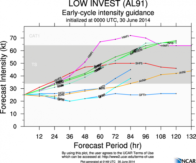
So what is this?

Image
0 likes   

Alyono
Professional-Met
Professional-Met
Posts: 6961
Joined: Fri Apr 26, 2013 3:52 pm
Location: Texas Coast

#218 Postby Alyono » Sun Jun 29, 2014 11:07 pm

That is HWRF and SHIPS based models intensifying this. Explained earlier why those are not valid

Now, the 0Z GFS IS developing this, but not until late in the week and it does not appear to entirely be tropical (enough so to get a name, however)
0 likes   

ozonepete
Professional-Met
Professional-Met
Posts: 4743
Joined: Mon Sep 07, 2009 3:23 pm
Location: From Ozone Park, NYC / Now in Brooklyn, NY

Re:

#219 Postby ozonepete » Sun Jun 29, 2014 11:12 pm

Alyono wrote:That is HWRF and SHIPS based models intensifying this. Explained earlier why those are not valid

Now, the 0Z GFS IS developing this, but not until late in the week and it does not appear to entirely be tropical (enough so to get a name, however)


It's not just HWRF and SHIPS, it's others including GFDL and AVN on there as well...
0 likes   

Aric Dunn
Category 5
Category 5
Posts: 21238
Age: 42
Joined: Sun Sep 19, 2004 9:58 pm
Location: Ready for the Chase.
Contact:

Re: Re:

#220 Postby Aric Dunn » Sun Jun 29, 2014 11:28 pm

ozonepete wrote:
Alyono wrote:That is HWRF and SHIPS based models intensifying this. Explained earlier why those are not valid

Now, the 0Z GFS IS developing this, but not until late in the week and it does not appear to entirely be tropical (enough so to get a name, however)


It's not just HWRF and SHIPS, it's others including GFDL and AVN on there as well...

Not only that. We all know that models are terrible at cyclogenisis in short term.. they can do very well in a general sense over time but can't say hey this hour it looks terrible the next hour it looks better then recon go out or so some other obs say hey we have depression or storm... too many people rely on models that are inherently flaud with cyclogenisis. Thats why the nhc does a series of short term updates a forecast .. once a system is established the models do overall quite well with large scale synoptic progression. Until its established the models are not going to get it right only give you general sense of direction... even though the hwrf and gfdl are technically intensity models they stl do not do well with cyclogenisis and thus are mute at this point. Only a little knowledge and direct observations will better the short term forecasts. Always.
0 likes   
Note: If I make a post that is brief. Please refer back to previous posts for the analysis or reasoning. I do not re-write/qoute what my initial post said each time.
If there is nothing before... then just ask :)

Space & Atmospheric Physicist, Embry-Riddle Aeronautical University,
I believe the sky is falling...


Return to “2014”

Who is online

Users browsing this forum: No registered users and 2 guests