ATL: BERTHA - Models

Moderator: S2k Moderators

Message
Author
User avatar
TheStormExpert
Category 5
Category 5
Posts: 8487
Age: 30
Joined: Wed Feb 16, 2011 5:38 pm
Location: Palm Beach Gardens, FL

Re: ATL: INVEST 93L - Models

#21 Postby TheStormExpert » Mon Jul 28, 2014 10:36 am

Blown Away wrote:Image
12z... Looks like a close miss to the NE Caribbean... Goes below 20/60 and through Hebert Box...

I feel the whole "Hebert Box" theory is overrated and means very little on track of these systems.
0 likes   
The following post is NOT an official forecast and should not be used as such. It is just the opinion of the poster and may or may not be backed by sound meteorological data. It is NOT endorsed by storm2k.org.

User avatar
gatorcane
S2K Supporter
S2K Supporter
Posts: 23499
Age: 46
Joined: Sun Mar 13, 2005 3:54 pm
Location: Boca Raton, FL

#22 Postby gatorcane » Mon Jul 28, 2014 10:48 am

12Z GFS running..through 66 hours. So far 1MB stronger but slightly slower on the westward motion than the 06Z.
0 likes   

User avatar
gatorcane
S2K Supporter
S2K Supporter
Posts: 23499
Age: 46
Joined: Sun Mar 13, 2005 3:54 pm
Location: Boca Raton, FL

#23 Postby gatorcane » Mon Jul 28, 2014 11:16 am

12Z GFS out through 138 hours. Track is slightly slower, strength is higher, and track shifted to the right just missing the Leewards to the NE...1003MB. That is a 5MB drop from the 06Z run:

Image
0 likes   

User avatar
SFLcane
S2K Supporter
S2K Supporter
Posts: 9627
Age: 46
Joined: Sat Jun 05, 2010 1:44 pm
Location: Lake Worth Florida

Re: ATL: INVEST 93L - Models

#24 Postby SFLcane » Mon Jul 28, 2014 11:21 am

Not much there to keep from recurving gains latitude pretty quickly.
0 likes   

User avatar
TheStormExpert
Category 5
Category 5
Posts: 8487
Age: 30
Joined: Wed Feb 16, 2011 5:38 pm
Location: Palm Beach Gardens, FL

Re:

#25 Postby TheStormExpert » Mon Jul 28, 2014 11:22 am

gatorcane wrote:12Z GFS out through 138 hours. Track is slightly slower, strength is higher, and track shifted to the right just missing the Leewards to the NE...1003MB. That is a 5MB drop from the 06Z run:

Image

High-Res. Graphic for 138hrs. :darrow:
Image
0 likes   
The following post is NOT an official forecast and should not be used as such. It is just the opinion of the poster and may or may not be backed by sound meteorological data. It is NOT endorsed by storm2k.org.

tolakram
Admin
Admin
Posts: 19182
Age: 60
Joined: Sun Aug 27, 2006 8:23 pm
Location: Florence, KY (name is Mark)

Re: ATL: INVEST 93L - Models

#26 Postby tolakram » Mon Jul 28, 2014 11:22 am

TheStormExpert wrote:
Blown Away wrote:12z... Looks like a close miss to the NE Caribbean... Goes below 20/60 and through Hebert Box...

I feel the whole "Hebert Box" theory is overrated and means very little on track of these systems.


Many people get the definition backwards. Most storms that hit Florida pass through the Hebert box(s), but a storm passing through the box does not have a higher chance of hitting Florida. I'm not actually sure of the chances, but the idea was basically if a storm misses the boxes it had a much lower chance to hit Florida.

http://en.wikipedia.org/wiki/Hebert_Box

While these boxes provide an indication that a hurricane may threaten South Florida, a hurricane does not have to pass through one to strike there, as were the case with the Labor Day Hurricane of 1935 and Hurricane Andrew, though the latter did skirt the edges of the eastern box. Additionally, a hurricane which does pass through a Hebert Box can very easily miss Florida, or indeed any landfall entirely.[3] Hebert himself acknowledged that the boxes are not a guarantee of hurricane landfall either way, but cautions that if a hurricane passes through one, "really, really pay attention. We worry plenty in August and September when one goes through that box, and we have a certain comfort level when one misses the box."[1]
0 likes   
M a r k
- - - - -
Join us in chat: Storm2K Chatroom Invite. Android and IOS apps also available.

The posts in this forum are NOT official forecasts and should not be used as such. Posts are NOT endorsed by any professional institution or STORM2K.org. For official information and forecasts, please refer to NHC and NWS products.

User avatar
KWT
Category 5
Category 5
Posts: 31391
Joined: Tue Aug 17, 2004 11:02 am
Location: UK!!!

#27 Postby KWT » Mon Jul 28, 2014 11:23 am

More aggressive run this time which leads to a quicker lift to the NW compared to the 06z.

I do think the GFS is being too aggressive with its lift to the NW and maybe a little quick on the strengthening side of things. Still think the LA are located to get hit, but by that time it should start to feel the shear unless it moves VERY slowly to the west, and I don't think that is going to be the case.

Unless the shear wall strips it totally, I do think this one will recurve between 70-80W
Last edited by KWT on Mon Jul 28, 2014 11:26 am, edited 1 time in total.
0 likes   
Personal Forecast Disclaimer:
The posts in this forum are NOT official forecast and should not be used as such. They are just the opinion of the poster and may or may not be backed by sound meteorological data. They are NOT endorsed by any professional institution or storm2k.org. For official information, please refer to the NHC and NWS products

User avatar
gatorcane
S2K Supporter
S2K Supporter
Posts: 23499
Age: 46
Joined: Sun Mar 13, 2005 3:54 pm
Location: Boca Raton, FL

#28 Postby gatorcane » Mon Jul 28, 2014 11:24 am

If you recall the GFS also wanted to lift out TD #2 to the NW very quickly but this time it probably is right if 93L develops as quick as it thinks it will looking at the steering flow.
Last edited by gatorcane on Mon Jul 28, 2014 11:25 am, edited 1 time in total.
0 likes   

User avatar
wxman57
Moderator-Pro Met
Moderator-Pro Met
Posts: 22506
Age: 66
Joined: Sat Jun 21, 2003 8:06 pm
Location: Houston, TX (southwest)

Re: ATL: INVEST 93L - Models

#29 Postby wxman57 » Mon Jul 28, 2014 11:25 am

GFS is probably recurving it too quickly. I'm seeing peak winds of 60kts in the 12Z GFS runs as the storm nears the islands.
0 likes   

Alyono
Professional-Met
Professional-Met
Posts: 6961
Joined: Fri Apr 26, 2013 3:52 pm
Location: Texas Coast

#30 Postby Alyono » Mon Jul 28, 2014 11:26 am

GFS track is absurd

I've said it before and I'll say it again. Louis Uccelini, fix your model! It's been 15 years where the GFS has taken systems too far to the north too quickly despite a strong ridge being present
0 likes   

Alyono
Professional-Met
Professional-Met
Posts: 6961
Joined: Fri Apr 26, 2013 3:52 pm
Location: Texas Coast

#31 Postby Alyono » Mon Jul 28, 2014 11:27 am

let me expand, missing the Caribbean in of itself is NOT absurd. Turning this to the NW at 45W to miss the Caribbean is, especially when there is a strong ridge north of the systen
0 likes   

User avatar
TheStormExpert
Category 5
Category 5
Posts: 8487
Age: 30
Joined: Wed Feb 16, 2011 5:38 pm
Location: Palm Beach Gardens, FL

#32 Postby TheStormExpert » Mon Jul 28, 2014 11:28 am

Looks to me like the trough has lifted out by 150hrs. and there is a light steering environment: :darrow:
Image
0 likes   
The following post is NOT an official forecast and should not be used as such. It is just the opinion of the poster and may or may not be backed by sound meteorological data. It is NOT endorsed by storm2k.org.

User avatar
Riptide
Category 2
Category 2
Posts: 753
Age: 32
Joined: Fri Jul 23, 2010 3:33 pm
Location: Cape May, New Jersey
Contact:

Re: ATL: INVEST 93L - Models

#33 Postby Riptide » Mon Jul 28, 2014 11:28 am

On closer examination, a ULL or something embeded inside the Bermuda high is the main catalyst for the early recurve.

Image
0 likes   

User avatar
KWT
Category 5
Category 5
Posts: 31391
Joined: Tue Aug 17, 2004 11:02 am
Location: UK!!!

Re:

#34 Postby KWT » Mon Jul 28, 2014 11:33 am

Alyono wrote:let me expand, missing the Caribbean in of itself is NOT absurd. Turning this to the NW at 45W to miss the Caribbean is, especially when there is a strong ridge north of the systen


Hard to imagine it turning as soon as the model wants it to.

There is enough weakness in the upper high to send it NW, but with that being said the pattern kind of flattens out across the east states by 180hrs so whatever track it is on at that point will probably stay that way.
0 likes   
Personal Forecast Disclaimer:
The posts in this forum are NOT official forecast and should not be used as such. They are just the opinion of the poster and may or may not be backed by sound meteorological data. They are NOT endorsed by any professional institution or storm2k.org. For official information, please refer to the NHC and NWS products

User avatar
gatorcane
S2K Supporter
S2K Supporter
Posts: 23499
Age: 46
Joined: Sun Mar 13, 2005 3:54 pm
Location: Boca Raton, FL

Re:

#35 Postby gatorcane » Mon Jul 28, 2014 11:33 am

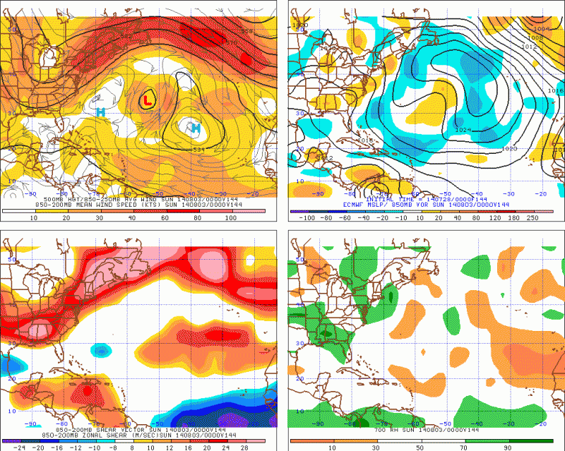
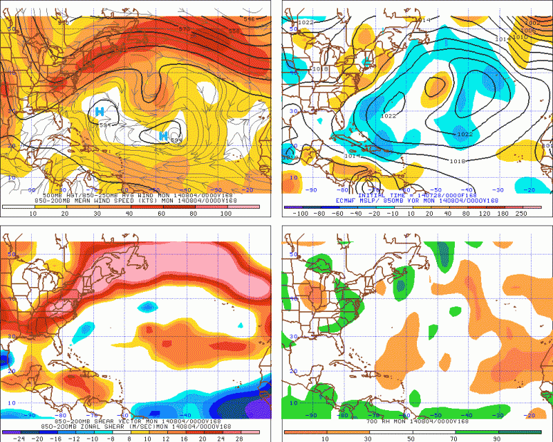
TheStormExpert wrote:Looks to me like the trough has lifted out by 150hrs. and there is a light steering environment: :darrow:


Yes I do see the 12Z GFS is not showing the trough any longer....

But the Bermuda High isn't strong either looking at the run out through 180 hours
Last edited by gatorcane on Mon Jul 28, 2014 11:35 am, edited 1 time in total.
0 likes   

User avatar
TheStormExpert
Category 5
Category 5
Posts: 8487
Age: 30
Joined: Wed Feb 16, 2011 5:38 pm
Location: Palm Beach Gardens, FL

#36 Postby TheStormExpert » Mon Jul 28, 2014 11:34 am

Go home GFS your drunk! :lol:(168hrs.)
Image
Image
Image
0 likes   
The following post is NOT an official forecast and should not be used as such. It is just the opinion of the poster and may or may not be backed by sound meteorological data. It is NOT endorsed by storm2k.org.

User avatar
NDG
S2K Supporter
S2K Supporter
Posts: 14947
Joined: Sun Jul 09, 2006 10:14 pm
Location: Orlando, FL

#37 Postby NDG » Mon Jul 28, 2014 11:54 am

A lot of people are talking about the shear axis in the eastern Caribbean but the models have been trending towards lessening shear in the area of the Lesser Antilles, so a track closer to the northern Windward Islands on north will make 93L escape the stronger shear of the central Caribbean.
Even the Euro is forecasting lesser windshear for this area. But as we know, UL winds are very difficult to forecast by the models past 72 hrs.

Image
Image
0 likes   

User avatar
KWT
Category 5
Category 5
Posts: 31391
Joined: Tue Aug 17, 2004 11:02 am
Location: UK!!!

#38 Postby KWT » Mon Jul 28, 2014 11:57 am

Yes less troughing on the 12z GFS, but even so its still more than enough to lift the system out, especially with that little cut-off low that swings round the base of that upper high between 96-144hrs which in effect is acting like a magnet.

CMC comes close to the LA but probably just misses them.
0 likes   
Personal Forecast Disclaimer:
The posts in this forum are NOT official forecast and should not be used as such. They are just the opinion of the poster and may or may not be backed by sound meteorological data. They are NOT endorsed by any professional institution or storm2k.org. For official information, please refer to the NHC and NWS products

User avatar
NDG
S2K Supporter
S2K Supporter
Posts: 14947
Joined: Sun Jul 09, 2006 10:14 pm
Location: Orlando, FL

#39 Postby NDG » Mon Jul 28, 2014 12:02 pm

I would not doubting that it will gain latitude as is approaches the area between the 50th and 60th longitude as there will be a weakness in the ridge SE of Bermuda but as it starts bumping into the Bermuda ridge it should go back to a more WNW track closer to the Bahamas than what the GFS is showing, IMO.

Personal Forecast Disclaimer:
The posts in this forum are NOT official forecast and should not be used as such. They are just the opinion of the poster and may or may not be backed by sound meteorological data. They are NOT endorsed by any professional institution or storm2k.org. For official information, please refer to the NHC and NWS products.
0 likes   

User avatar
TheStormExpert
Category 5
Category 5
Posts: 8487
Age: 30
Joined: Wed Feb 16, 2011 5:38 pm
Location: Palm Beach Gardens, FL

#40 Postby TheStormExpert » Mon Jul 28, 2014 12:06 pm

:uarrow: I'm starting to wonder if we are getting too held up on the GFS always having a tendency to try and recurve systems too soon. Something in my gut tells me this will only be a threat to the NE Leeward Islands, and Bermuda at worst.
0 likes   
The following post is NOT an official forecast and should not be used as such. It is just the opinion of the poster and may or may not be backed by sound meteorological data. It is NOT endorsed by storm2k.org.


Return to “2014”

Who is online

Users browsing this forum: No registered users and 7 guests