EPAC: MARIE - Post-Tropical

Moderator: S2k Moderators

Message
Author
User avatar
Yellow Evan
Professional-Met
Professional-Met
Posts: 16143
Age: 27
Joined: Fri Jul 15, 2011 12:48 pm
Location: Henderson, Nevada/Honolulu, HI
Contact:

Re:

#161 Postby Yellow Evan » Fri Aug 22, 2014 1:54 pm

Ntxw wrote:Any maps of Linda? Arguably thats the highest bar for EPAC systems


I posted some sat images a few pages back.

But here's Linda's track.

Image
0 likes   

User avatar
Kingarabian
S2K Supporter
S2K Supporter
Posts: 15980
Joined: Sat Aug 08, 2009 3:06 am
Location: Honolulu, Hawaii

#162 Postby Kingarabian » Fri Aug 22, 2014 1:55 pm

ADT will be our friend for this storm.

Code: Select all

        CI# /Pressure/ Vmax
                3.3 /1001.2mb/ 51.0kt

     
             Final T#  Adj T#  Raw T#
                3.3     3.5     4.0

 Center Temp : -77.6C    Cloud Region Temp : -70.1C

 Scene Type : UNIFORM CDO CLOUD REGION
0 likes   
RIP Kobe Bryant

User avatar
cycloneye
Admin
Admin
Posts: 145295
Age: 68
Joined: Thu Oct 10, 2002 10:54 am
Location: San Juan, Puerto Rico

Re:

#163 Postby cycloneye » Fri Aug 22, 2014 1:58 pm

Ntxw wrote:Any maps of Linda? Arguably thats the highest bar for EPAC systems


Linda was a very powerful beauty.Will Marie rival her?

Image

Image
0 likes   
Visit the Caribbean-Central America Weather Thread where you can find at first post web cams,radars
and observations from Caribbean basin members Click Here

User avatar
srainhoutx
S2K Supporter
S2K Supporter
Posts: 6919
Age: 67
Joined: Sun Jan 14, 2007 11:34 am
Location: Haywood County, NC
Contact:

Re: Re:

#164 Postby srainhoutx » Fri Aug 22, 2014 2:01 pm

cycloneye wrote:
Ntxw wrote:Any maps of Linda? Arguably thats the highest bar for EPAC systems


Linda was a very powerful beauty.Will Marie rival her?


Image
0 likes   
Carla/Alicia/Jerry(In The Eye)/Michelle/Charley/Ivan/Dennis/Katrina/Rita/Wilma/Ike/Harvey

Member: National Weather Association
Wx Infinity Forums
http://wxinfinity.com/index.php

Facebook.com/WeatherInfinity
Twitter @WeatherInfinity

tolakram
Admin
Admin
Posts: 20009
Age: 62
Joined: Sun Aug 27, 2006 8:23 pm
Location: Florence, KY (name is Mark)

Re: EPAC: MARIE - Tropical Storm

#165 Postby tolakram » Fri Aug 22, 2014 2:22 pm

0 likes   
M a r k
- - - - -
Join us in chat: Storm2K Chatroom Invite. Android and IOS apps also available.

The posts in this forum are NOT official forecasts and should not be used as such. Posts are NOT endorsed by any professional institution or STORM2K.org. For official information and forecasts, please refer to NHC and NWS products.

tolakram
Admin
Admin
Posts: 20009
Age: 62
Joined: Sun Aug 27, 2006 8:23 pm
Location: Florence, KY (name is Mark)

Re: EPAC: MARIE - Tropical Storm

#166 Postby tolakram » Fri Aug 22, 2014 2:24 pm

0 likes   
M a r k
- - - - -
Join us in chat: Storm2K Chatroom Invite. Android and IOS apps also available.

The posts in this forum are NOT official forecasts and should not be used as such. Posts are NOT endorsed by any professional institution or STORM2K.org. For official information and forecasts, please refer to NHC and NWS products.

tolakram
Admin
Admin
Posts: 20009
Age: 62
Joined: Sun Aug 27, 2006 8:23 pm
Location: Florence, KY (name is Mark)

Re: EPAC: MARIE - Tropical Storm

#167 Postby tolakram » Fri Aug 22, 2014 2:32 pm

0 likes   
M a r k
- - - - -
Join us in chat: Storm2K Chatroom Invite. Android and IOS apps also available.

The posts in this forum are NOT official forecasts and should not be used as such. Posts are NOT endorsed by any professional institution or STORM2K.org. For official information and forecasts, please refer to NHC and NWS products.

supercane4867
Category 5
Category 5
Posts: 4966
Joined: Wed Nov 14, 2012 10:43 am

Re: EPAC: MARIE - Tropical Storm

#168 Postby supercane4867 » Fri Aug 22, 2014 2:50 pm

Linda was one of the only two hurricanes to reach T8.0 on objective Dvorak analysis which topped the scale, another one was Gilbert in the Atlantic side
0 likes   

User avatar
somethingfunny
ChatStaff
ChatStaff
Posts: 3926
Age: 37
Joined: Thu May 31, 2007 10:30 pm
Location: McKinney, Texas

#169 Postby somethingfunny » Fri Aug 22, 2014 2:51 pm

I hope we can get rapid scan satellite running for Marie's intensification!
0 likes   
I am not a meteorologist, and any posts made by me are not official forecasts or to be interpreted as being intelligent. These posts are just my opinions and are probably silly opinions.

User avatar
Yellow Evan
Professional-Met
Professional-Met
Posts: 16143
Age: 27
Joined: Fri Jul 15, 2011 12:48 pm
Location: Henderson, Nevada/Honolulu, HI
Contact:

Re: EPAC: MARIE - Tropical Storm

#170 Postby Yellow Evan » Fri Aug 22, 2014 2:53 pm

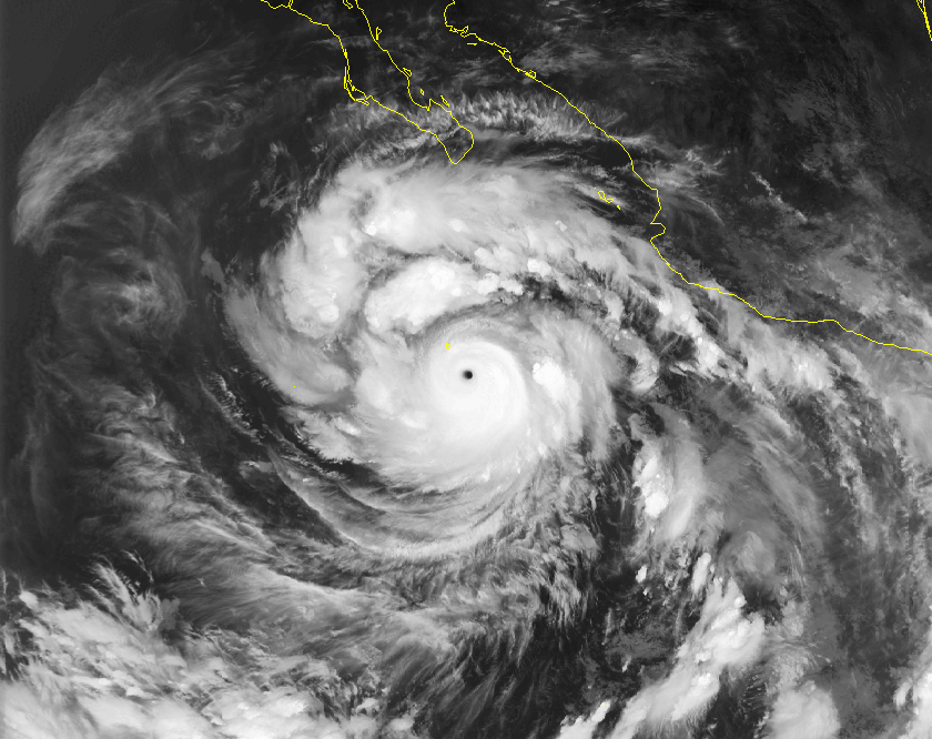
supercane4867 wrote:Linda was one of the only two hurricanes to reach T8.0 on objective Dvorak analysis which topped the scale, another one was Gilbert in the Atlantic side


Not counting typhoons I assume.
0 likes   

User avatar
Yellow Evan
Professional-Met
Professional-Met
Posts: 16143
Age: 27
Joined: Fri Jul 15, 2011 12:48 pm
Location: Henderson, Nevada/Honolulu, HI
Contact:

#171 Postby Yellow Evan » Fri Aug 22, 2014 2:58 pm

ATCF revised down to 50 knts.

EP, 13, 2014082218, , BEST, 0, 132N, 1030W, 50, 1000, TS, 34, NEQ, 70, 30, 0, 70, 1012, 200, 20, 0, 0, E, 0, , 0, 0, MARIE, D,
EP, 13, 2014082218, , BEST, 0, 132N, 1030W, 50, 1000, TS, 50, NEQ, 30, 0, 0, 30, 1012, 200, 20, 0, 0, E, 0, , 0, 0, MARIE, D,
0 likes   

User avatar
Kingarabian
S2K Supporter
S2K Supporter
Posts: 15980
Joined: Sat Aug 08, 2009 3:06 am
Location: Honolulu, Hawaii

#172 Postby Kingarabian » Fri Aug 22, 2014 2:59 pm

Image

Buzzsaw disc look.
0 likes   
RIP Kobe Bryant

User avatar
jaguarjace
Category 4
Category 4
Posts: 975
Age: 30
Joined: Sat Jun 11, 2011 7:38 am
Location: Khon Kaen, Thailand

Re: EPAC: MARIE - Tropical Storm

#173 Postby jaguarjace » Fri Aug 22, 2014 3:08 pm

Looks great.
Image
0 likes   
Owner of the Tropical Archive YouTube channel
Web Developer at Force Thirteen
Twitter/X : @force13_support

User avatar
Yellow Evan
Professional-Met
Professional-Met
Posts: 16143
Age: 27
Joined: Fri Jul 15, 2011 12:48 pm
Location: Henderson, Nevada/Honolulu, HI
Contact:

#174 Postby Yellow Evan » Fri Aug 22, 2014 3:15 pm

I think it may be in a slight phase of unarrested development right now. Still intensifying, but has a bit more banding than I'm use to.
0 likes   

User avatar
cycloneye
Admin
Admin
Posts: 145295
Age: 68
Joined: Thu Oct 10, 2002 10:54 am
Location: San Juan, Puerto Rico

Re: EPAC: MARIE - Tropical Storm

#175 Postby cycloneye » Fri Aug 22, 2014 3:35 pm

Peak now up to 115kts.

TROPICAL STORM MARIE DISCUSSION NUMBER 4
NWS NATIONAL HURRICANE CENTER MIAMI FL EP132014
200 PM PDT FRI AUG 22 2014

Marie continues to intensify. Satellite images show a well-
organized cloud pattern, with considerable deep convection and
numerous rain bands surrounding the center. The current intensity
estimate is set at 50 kt, which is based on a blend of subjective
Dvorak estimates from TAFB and SAB, ADT values from UW/CIMSS, and
data from a couple of recent ASCAT overpasses. The tropical cyclone
will be moving over very warm waters of almost 30 deg C and vertical
shear is forecast to remain low throughout the period. Some of the
intensity guidance is very aggressive in strengthening Marie. In
particular the SHIPS model, which shows strengthening to Category 4
status in 48 hours, and the SHIPS Rapid Intensification Index, which
shows a 59 percent chance of a 35-kt increase in winds over the next
24 hours. The official intensity forecast is close to the SHIPS
guidance through 48 hours, and is a blend of the LGEM and SHIPS
models thereafter.

Marie continues its west-northwestward trek and the motion estimate
is 285/12, which is close to the climatological mean for the basin.
The track forecast and forecast reasoning are basically unchanged.
Marie should move along the southern periphery of a mid-
tropospheric ridge that is forecast to build westward from northern
Mexico through the forecast period. The official track forecast is
similar to the previous one and remains close to the model
consensus.

The forecast wind radii at days 2-3 have been increased, based on
the global models, which depict a large hurricane by that time
frame.

FORECAST POSITIONS AND MAX WINDS

INIT 22/2100Z 13.4N 103.5W 50 KT 60 MPH
12H 23/0600Z 13.8N 105.1W 65 KT 75 MPH
24H 23/1800Z 14.4N 107.1W 85 KT 100 MPH
36H 24/0600Z 14.9N 109.0W 105 KT 120 MPH
48H 24/1800Z 15.8N 110.7W 115 KT 135 MPH
72H 25/1800Z 17.5N 114.0W 115 KT 135 MPH
96H 26/1800Z 20.0N 118.0W 100 KT 115 MPH
120H 27/1800Z 22.5N 122.5W 85 KT 100 MPH

$$
Forecaster Pasch
0 likes   
Visit the Caribbean-Central America Weather Thread where you can find at first post web cams,radars
and observations from Caribbean basin members Click Here

hurricanes1234
Category 5
Category 5
Posts: 2907
Joined: Sat Jul 28, 2012 6:19 pm
Location: Trinidad and Tobago

#176 Postby hurricanes1234 » Fri Aug 22, 2014 3:58 pm

This is amazing! I won't rule out possible Category 5 status. Can we beat Linda? I don't think so, because that was an extremely powerful hurricane. I'm estimating around 135-145 knots.
0 likes   
PLEASE NOTE: With the exception of information from weather agencies that I may copy and paste here, my posts will NEVER be official, since I am NOT a meteorologist. They are solely my amateur opinion, and may or may not be accurate. Therefore, please DO NOT use them as official details, particularly when making important decisions. Thank you.

User avatar
Yellow Evan
Professional-Met
Professional-Met
Posts: 16143
Age: 27
Joined: Fri Jul 15, 2011 12:48 pm
Location: Henderson, Nevada/Honolulu, HI
Contact:

Re:

#177 Postby Yellow Evan » Fri Aug 22, 2014 4:30 pm

hurricanes1234 wrote:This is amazing! I won't rule out possible Category 5 status. Can we beat Linda? I don't think so, because that was an extremely powerful hurricane. I'm estimating around 135-145 knots.


It can. Just not likely since those super intense canes are rare. The posts in this forum are NOT official forecast and should not be used as such. They are just the opinion of the poster and may or may not be backed by sound meteorological data. They are NOT endorsed by any professional institution or storm2k.org. For official information, please refer to the NHC and NWS products.
0 likes   

User avatar
mrbagyo
Category 5
Category 5
Posts: 3715
Age: 33
Joined: Thu Apr 12, 2012 9:18 am
Location: 14.13N 120.98E
Contact:

Re: EPAC: MARIE - Tropical Storm

#178 Postby mrbagyo » Fri Aug 22, 2014 4:36 pm

Image
0 likes   
The posts in this forum are NOT official forecast and should not be used as such. They are just the opinion of the poster and may or may not be backed by sound meteorological data. They are NOT endorsed by any professional institution or storm2k.org. For official information, please refer to RSMC, NHC and NWS products.

User avatar
Hurricane_Luis
Category 2
Category 2
Posts: 723
Age: 27
Joined: Sat Jun 23, 2012 3:14 pm
Location: Tiptree, Essex, United Kingdom
Contact:

#179 Postby Hurricane_Luis » Fri Aug 22, 2014 6:56 pm

Just looking at ADT and the pressure has gone down from 997.2 mbar to 995.9 mbar. Wind speed also up from 57kts to 60 kts. Start of RI?
0 likes   

User avatar
cycloneye
Admin
Admin
Posts: 145295
Age: 68
Joined: Thu Oct 10, 2002 10:54 am
Location: San Juan, Puerto Rico

Re: EPAC: MARIE - Tropical Storm

#180 Postby cycloneye » Fri Aug 22, 2014 7:02 pm

Is almost there to become a hurricane.

Image
0 likes   
Visit the Caribbean-Central America Weather Thread where you can find at first post web cams,radars
and observations from Caribbean basin members Click Here


Return to “2014”

Who is online

Users browsing this forum: No registered users and 2 guests