ATL: CRISTOBAL - Post-Tropical - Discussion
Moderator: S2k Moderators

A tad west of where I thought it was so there's still a small amount of shear affecting it.
0 likes
The above post is not official and should not be used as such. It is the opinion of the poster and may or may not be backed by sound meteorological data. It is not endorsed by any professional institution or storm2k.org. For official information, please refer to the NHC and NWS products.


Re: ATL: FOUR - Tropical Depression - Discussion
Oh... the "Nasa site". Thanks. Won't load on my smart phone for some reason (strange, I thought it used too...?)
0 likes
Andy D
(For official information, please refer to the NHC and NWS products.)
(For official information, please refer to the NHC and NWS products.)
-
tolakram
- Admin

- Posts: 20186
- Age: 62
- Joined: Sun Aug 27, 2006 8:23 pm
- Location: Florence, KY (name is Mark)
Re: ATL: FOUR - Tropical Depression - Discussion
The html5 loop should load. Try a small window ...
Phone shaped.
http://wwwghcc.msfc.nasa.gov/cgi-bin/get-goes?satellite=GOES-E%20CONUS&lat=23&lon=-73&info=ir&zoom=2&width=300&height=400&quality=95&type=Animation&palette=ir3.pal&numframes=15
Phone shaped.
http://wwwghcc.msfc.nasa.gov/cgi-bin/get-goes?satellite=GOES-E%20CONUS&lat=23&lon=-73&info=ir&zoom=2&width=300&height=400&quality=95&type=Animation&palette=ir3.pal&numframes=15
0 likes
M a r k
- - - - -
Join us in chat: Storm2K Chatroom Invite. Android and IOS apps also available.
The posts in this forum are NOT official forecasts and should not be used as such. Posts are NOT endorsed by any professional institution or STORM2K.org. For official information and forecasts, please refer to NHC and NWS products.
Well I guess this going to be a recurve. Not seeing a lot of ridging in all the 00z models.
0 likes
The posts in this forum are NOT official forecast and should not be used as such. They are just the opinion of the poster and may or may not be backed by sound meteorological data. They are NOT endorsed by any professional institution or storm2k.org. For official information, please refer to the NHC and NWS products.
Re: ATL: FOUR - Tropical Depression - Discussion
tolakram wrote:The html5 loop should load. Try a small window ...
Phone shaped.
http://wwwghcc.msfc.nasa.gov/cgi-bin/get-goes?satellite=GOES-E%20CONUS&lat=23&lon=-73&info=ir&zoom=2&width=300&height=400&quality=95&type=Animation&palette=ir3.pal&numframes=15
Thanks Mark, but "no-go". The frames appeared to be in play mode, but no picture. Tried as you suggested. It's odd; my phone is an Android (Samsung Note II) & should play that loop. Oh well, am all stormed- out LOL. Tomorrow's another day - G'night all!
0 likes
Andy D
(For official information, please refer to the NHC and NWS products.)
(For official information, please refer to the NHC and NWS products.)
Both recon passes through the storm seem to have missed the center by a bit.
0 likes
The above post is not official and should not be used as such. It is the opinion of the poster and may or may not be backed by sound meteorological data. It is not endorsed by any professional institution or storm2k.org. For official information, please refer to the NHC and NWS products.
-
SouthFLTropics

- Category 5

- Posts: 4258
- Age: 50
- Joined: Thu Aug 14, 2003 8:04 am
- Location: Port St. Lucie, Florida
Re: ATL: FOUR - Tropical Depression - Discussion
Well it appears for right now that once again we have dodged another one here in FL. I don't want anyone to think that I'm disappointed because our time will come once again. With that said this has turned out to be one of the most anti-climatic storms I can ever recall. All hype and no substance.
For the record...if something changes and that turns out being wrong I like my crow served medium rare with a cold brew to wash it down.
SFT
For the record...if something changes and that turns out being wrong I like my crow served medium rare with a cold brew to wash it down.
SFT
0 likes
Fourth Generation Florida Native
Personal Storm History: David 79, Andrew 92, Erin 95, Floyd 99, Irene 99, Frances 04, Jeanne 04, Wilma 05, Matthew 16, Irma 17, Ian 22, Nicole 22, Milton 24
Personal Storm History: David 79, Andrew 92, Erin 95, Floyd 99, Irene 99, Frances 04, Jeanne 04, Wilma 05, Matthew 16, Irma 17, Ian 22, Nicole 22, Milton 24

-
somethingfunny

- ChatStaff

- Posts: 3926
- Age: 37
- Joined: Thu May 31, 2007 10:30 pm
- Location: McKinney, Texas


Pressure down from 1004 to 1001 between the two latest center fixes, maybe convection starting to have some effect.
Edit: Looks like it's up to 1003, not moving much right now.
Edit: Looks like it's up to 1003, not moving much right now.
0 likes
Personal Forecast Disclaimer:
The posts in this forum are NOT official forecast and should not be used as such. They are just the opinion of the poster and may or may not be backed by sound meteorological data. They are NOT endorsed by any professional institution or storm2k.org. For official information, please refer to the NHC and NWS products.
The posts in this forum are NOT official forecast and should not be used as such. They are just the opinion of the poster and may or may not be backed by sound meteorological data. They are NOT endorsed by any professional institution or storm2k.org. For official information, please refer to the NHC and NWS products.


Re: ATL: FOUR - Tropical Depression - Discussion
TROPICAL STORM CRISTOBAL TROPICAL CYCLONE UPDATE
NWS NATIONAL HURRICANE CENTER MIAMI FL AL042014
620 AM AST SUN AUG 24 2014
...DEPRESSION STRENGTHENS TO A TROPICAL STORM...
NOAA AND AIR FORCE RESERVE HURRICANE HUNTER AIRCRAFT DATA INDICATE
THAT THE DEPRESSION HAS STRENGTHENED TO TROPICAL STORM CRISTOBAL.
THE MAXIMUM WINDS ARE ESTIMATED TO BE 45 MPH...75 KM/H WITH HIGHER
GUSTS.
SUMMARY OF 620 AM AST...1020 UTC...INFORMATION
--------------------------------------------------
LOCATION...22.9N 73.3W
ABOUT 40 MI...60 KM NNW OF MAYAGUANA ISLAND
ABOUT 120 MI...190 KM ESE OF LONG ISLAND
MAXIMUM SUSTAINED WINDS...45 MPH...75 KM/H
PRESENT MOVEMENT...NW OR 325 DEGREES AT 9 MPH...15 KM/H
MINIMUM CENTRAL PRESSURE...1002 MB...29.59 INCHES
$$
FORECASTER BROWN
0 likes
Re: ATL: FOUR - Tropical Depression - Discussion
LLC is in danger of being naked once the first visible shots come in.
0 likes

-
cycloneye

- Admin
- Posts: 149556
- Age: 69
- Joined: Thu Oct 10, 2002 10:54 am
- Location: San Juan, Puerto Rico
Re:
abajan wrote:Mods, please change the thread title
Apparently there were no fellow staff at the time of upgrade and I was taking a shower but title is edited.
0 likes
Visit the Caribbean-Central America Weather Thread where you can find at first post web cams,radars
and observations from Caribbean basin members Click Here
and observations from Caribbean basin members Click Here
-
Equilibrium

Its questionable wether this was all ready TS on the 23rd at the time of this pass was a one 50 knt flag.
The posts in this forum are NOT official forecast and should not be used as such. They are just the opinion of the poster and may or may not be backed by sound meteorological data. They are NOT endorsed by any professional institution or storm2k.org. For official information, please refer to the NHC and NWS products
0 likes
Re: ATL: CRISTOBAL - Tropical Storm - Discussion
Looks like there was an overshooting top just east of the LLC at sunrise
http://www.ssd.noaa.gov/PS/TROP/floater ... imated.gif
http://rammb.cira.colostate.edu/product ... 0_SWHR.GIF
http://www.ssd.noaa.gov/PS/TROP/floater ... imated.gif
http://rammb.cira.colostate.edu/product ... 0_SWHR.GIF
0 likes
Re: ATL: CRISTOBAL - Tropical Storm - Discussion
Outflow looks good on the east side due to ventilation from the ULL at about 15N 60W.
http://tropic.ssec.wisc.edu/real-time/w ... zoom=&time
However, it is bad on the west side due to the ULL at about 24N 83W.
This one is moving west into the GOM and could improve Cristobal's outflow during the day today.
http://tropic.ssec.wisc.edu/real-time/w ... oom=&time=
http://tropic.ssec.wisc.edu/real-time/w ... zoom=&time
However, it is bad on the west side due to the ULL at about 24N 83W.
This one is moving west into the GOM and could improve Cristobal's outflow during the day today.
http://tropic.ssec.wisc.edu/real-time/w ... oom=&time=
0 likes
Re: ATL: CRISTOBAL - Tropical Storm - Discussion
http://weather.msfc.nasa.gov/cgi-bin/post-goes
check out the small swirl you can see in the first set of frames on nasa's satellite.
looks to be dropping SW
check out the small swirl you can see in the first set of frames on nasa's satellite.
looks to be dropping SW
0 likes
The posts in this forum are NOT official forecast and should not be used as such. They are just the opinion of the poster and may or may not be backed by sound meteorological data. They are NOT endorsed by any professional institution or storm2k.org. For official information, please refer to the NHC and NWS products.
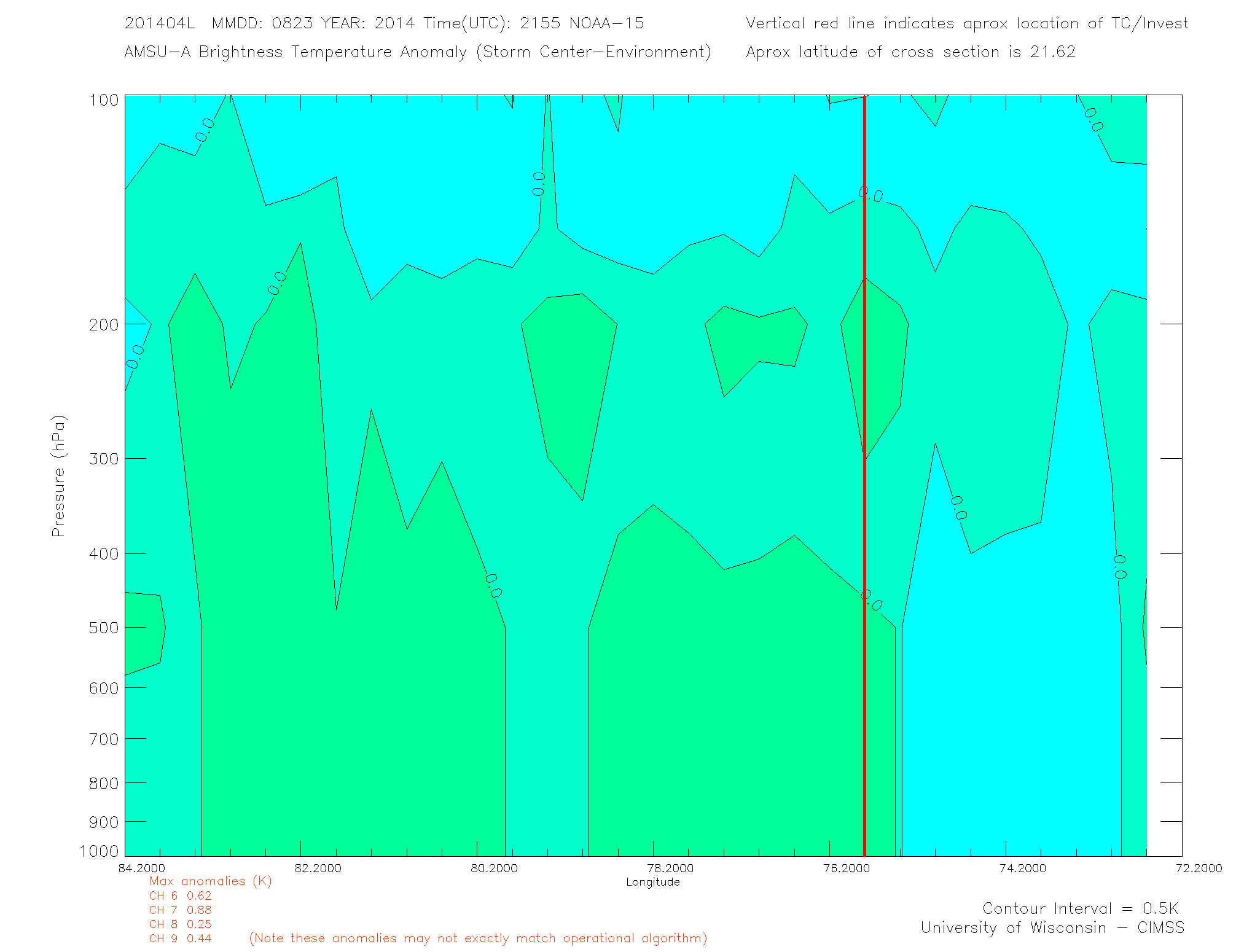
Re: ATL: CRISTOBAL - Tropical Storm - Discussion
Warm core at 200 to 300 mb.
http://tropic.ssec.wisc.edu/real-time/a ... _xsect.gif
However, there is a rather high inversion up to about 500 mb.
This is inhibiting convection at the LLC which could likely be an effect of the ULL to the west.
http://tropic.ssec.wisc.edu/real-time/a ... _xsect.gif
However, there is a rather high inversion up to about 500 mb.
This is inhibiting convection at the LLC which could likely be an effect of the ULL to the west.
0 likes
Who is online
Users browsing this forum: No registered users and 10 guests