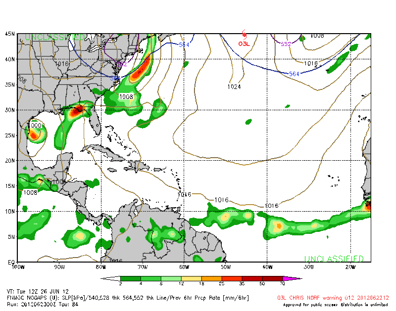
ATL: DEBBY - Post-Tropical

Moderator: S2k Moderators

Message
Author
User avatar
Hurricaneman
Category 5
Category 5
Posts: 7351
Age: 45
Joined: Tue Aug 31, 2004 3:24 pm
Location: central florida

Re: ATL: INVEST 96L - Models

#981 Postby Hurricaneman » Fri Jun 22, 2012 11:24 pm

Riptide wrote:
CYCLONE MIKE wrote:Only reason gfs is showing this moving east now is not because of trof picking it up but another system developimg off se coast no later than Monday leaving a weakness behind . No other models have shown a hint of this so as usual think the gfs is wrong again. Have to give it credit it is persistent :roll:

The GFS is trying to create a Beryl redux right now....it will fall short though because there is another shortwave digging into the Great Lakes.

:lol:


Im wondering if its picking up on some type of MCC and trying to make it a storm
0 likes   

User avatar
Jevo
S2K Supporter
S2K Supporter
Posts: 1729
Age: 47
Joined: Tue Aug 03, 2004 8:45 pm
Location: The Flemish Cap
Contact:

Re: ATL: INVEST 96L - Models

#982 Postby Jevo » Fri Jun 22, 2012 11:29 pm

Some Spaghetti for yas.. updated 5 mins ago

Image
0 likes   
Disclaimer: 50% of the time I have no clue of what I am talking about. Chances are I am taking a less than educated guess that sounds good because 10 years ago I stole Mike Watkins book 'The Hurricane and its Impact'. For official information please direct yourself to the NHC and their cadre of weather geniuses.

User avatar
Ptarmigan
Category 5
Category 5
Posts: 5313
Joined: Wed Aug 16, 2006 9:06 pm

Re: ATL: INVEST 96L - Models

#983 Postby Ptarmigan » Fri Jun 22, 2012 11:32 pm

ROCK wrote:75 still stalled


If it is stalled, it could dump heavy rain as much as 3 feet! :eek: :eek:

I noticed the models are all over the place.
Last edited by Ptarmigan on Fri Jun 22, 2012 11:34 pm, edited 1 time in total.
0 likes   

User avatar
Ivanhater
Storm2k Moderator
Storm2k Moderator
Posts: 11161
Age: 38
Joined: Fri Jul 01, 2005 8:25 am
Location: Pensacola

Re: ATL: INVEST 96L - Models

#984 Postby Ivanhater » Fri Jun 22, 2012 11:33 pm

GFS holds serve....TVCN still shows an east Gulf scenario. Even if the rest of the models come in the same, we are in the same boat we have been in....great :lol:
0 likes   
Michael

User avatar
Cainer
Tropical Storm
Tropical Storm
Posts: 188
Age: 34
Joined: Mon May 05, 2008 3:26 pm
Location: Yarmouth, Nova Scotia

#985 Postby Cainer » Fri Jun 22, 2012 11:35 pm

That has to be the most divergent spaghetti plot I've ever seen.
0 likes   

User avatar
Rgv20
S2K Supporter
S2K Supporter
Posts: 2466
Age: 39
Joined: Wed Jan 05, 2011 5:42 pm
Location: Edinburg/McAllen Tx

#986 Postby Rgv20 » Fri Jun 22, 2012 11:37 pm

0zNOGAPS still forecast the low to the Western Gulf.....Forecast valid for Tuesday Morning.

Image
0 likes   
The following post is NOT an official forecast and should not be used as such. It is just the opinion of the poster and may or may not be backed by sound meteorological data. It is NOT endorsed by any professional institution including storm2k.org For Official Information please refer to the NHC and NWS products.

User avatar
Hurricaneman
Category 5
Category 5
Posts: 7351
Age: 45
Joined: Tue Aug 31, 2004 3:24 pm
Location: central florida

Re: ATL: INVEST 96L - Models

#987 Postby Hurricaneman » Fri Jun 22, 2012 11:38 pm

Ptarmigan wrote:
ROCK wrote:75 still stalled


If it is stalled, it could dump heavy rain as much as 3 feet! :eek: :eek:

I noticed the models are all over the place.


If this run came through, everyone from New Orleans to Ft Myers would get historic flooding so I'm saying while I like tracking tropical cyclones I want nothing to do with this especially if its slow moving, but I believe we need another day to figure out which models are right or wrong

The posts in this forum are NOT official forecast and should not be used as such. They are just the opinion of the poster and may or may not be backed by sound meteorological data. They are NOT endorsed by any professional institution or storm2k.org. For official information, please refer to the NHC and NWS products
0 likes   

User avatar
Ivanhater
Storm2k Moderator
Storm2k Moderator
Posts: 11161
Age: 38
Joined: Fri Jul 01, 2005 8:25 am
Location: Pensacola

Re: ATL: INVEST 96L - Models

#988 Postby Ivanhater » Fri Jun 22, 2012 11:39 pm

Nogaps looks like it splits the low...but it is the nogaps..
0 likes   
Michael

User avatar
Riptide
Category 2
Category 2
Posts: 753
Age: 34
Joined: Fri Jul 23, 2010 3:33 pm
Location: Cape May, New Jersey
Contact:

Re: ATL: INVEST 96L - Models

#989 Postby Riptide » Fri Jun 22, 2012 11:47 pm

Ivanhater wrote:Nogaps looks like it splits the low...but it is the nogaps..

It says NoGaps(not available) on the model chart because nobody cares about it, jking. Personally, I don't look at it even though someone posted some model statistics last year....it's not far behind the CMC and UKmet.
0 likes   

CYCLONE MIKE
Category 5
Category 5
Posts: 2183
Joined: Tue Aug 31, 2004 6:04 pm
Location: Gonzales, LA

Re: ATL: INVEST 96L - Models

#990 Postby CYCLONE MIKE » Fri Jun 22, 2012 11:48 pm

Jevo, is that all the spaghetti plots or just some. Looks like a lot more are showing east vs north and west as saw earlier today.
0 likes   

User avatar
Jevo
S2K Supporter
S2K Supporter
Posts: 1729
Age: 47
Joined: Tue Aug 03, 2004 8:45 pm
Location: The Flemish Cap
Contact:

Re: ATL: INVEST 96L - Models

#991 Postby Jevo » Fri Jun 22, 2012 11:52 pm

CYCLONE MIKE wrote:Jevo, is that all the spaghetti plots or just some. Looks like a lot more are showing east vs north and west as saw earlier today.


A mix of both.. you'll see some 0z mixed in with some of the older runs in the image as indicated by the key at the top of it
0 likes   
Disclaimer: 50% of the time I have no clue of what I am talking about. Chances are I am taking a less than educated guess that sounds good because 10 years ago I stole Mike Watkins book 'The Hurricane and its Impact'. For official information please direct yourself to the NHC and their cadre of weather geniuses.

lebron23
Category 1
Category 1
Posts: 389
Age: 32
Joined: Sat May 24, 2008 11:58 am
Contact:

Re: ATL: INVEST 96L - Models

#992 Postby lebron23 » Fri Jun 22, 2012 11:54 pm

I would love to see which side of the models the NHC goes with if they had to make a projected path right now
0 likes   

User avatar
ROCK
Category 5
Category 5
Posts: 9484
Age: 54
Joined: Tue Aug 17, 2004 7:30 am
Location: Kemah, Texas

Re: ATL: INVEST 96L - Models

#993 Postby ROCK » Fri Jun 22, 2012 11:55 pm

maybe one big circle...... :lol: :lol:
0 likes   

User avatar
thundercam96
Tropical Storm
Tropical Storm
Posts: 129
Joined: Thu Aug 18, 2011 3:01 pm
Location: Boston, MA

Re: ATL: INVEST 96L - Models

#994 Postby thundercam96 » Fri Jun 22, 2012 11:56 pm

ROCK wrote:maybe one big circle...... :lol: :lol:


Or Just Covering The Whole Basin lol
0 likes   
Fay '08 / Mathew 16'

Personal Forecast Disclaimer: I am not a certified meteorologist, therefore, what is posted on this forum under my header should not be treated as an official forecast. Please refer to the NWS/NHC products for forecast information.

lebron23
Category 1
Category 1
Posts: 389
Age: 32
Joined: Sat May 24, 2008 11:58 am
Contact:

Re: ATL: INVEST 96L - Models

#995 Postby lebron23 » Fri Jun 22, 2012 11:57 pm

thundercam96 wrote:
ROCK wrote:maybe one big circle...... :lol: :lol:


Or Just Covering The Whole Basin lol


Tampico to Miami? :D :lol:
0 likes   

User avatar
boca
Category 5
Category 5
Posts: 6367
Age: 60
Joined: Mon Dec 15, 2003 8:49 am
Location: Boca Raton,FL

Re: ATL: INVEST 96L - Models

#996 Postby boca » Fri Jun 22, 2012 11:58 pm

The GFS could be picking up on that upper lever low south of Bermuda anyone agree with me?
0 likes   

User avatar
Ivanhater
Storm2k Moderator
Storm2k Moderator
Posts: 11161
Age: 38
Joined: Fri Jul 01, 2005 8:25 am
Location: Pensacola

Re: ATL: INVEST 96L - Models

#997 Postby Ivanhater » Fri Jun 22, 2012 11:59 pm

CMC looks like Louisiana/Texas border....

Northern shift....however, look how close it gets to the New Orleans

Image
0 likes   
Michael

User avatar
Rgv20
S2K Supporter
S2K Supporter
Posts: 2466
Age: 39
Joined: Wed Jan 05, 2011 5:42 pm
Location: Edinburg/McAllen Tx

#998 Postby Rgv20 » Fri Jun 22, 2012 11:59 pm

0zUKMET has landfall on Wednesday Evening on the Houston area..

Image
0 likes   
The following post is NOT an official forecast and should not be used as such. It is just the opinion of the poster and may or may not be backed by sound meteorological data. It is NOT endorsed by any professional institution including storm2k.org For Official Information please refer to the NHC and NWS products.

lebron23
Category 1
Category 1
Posts: 389
Age: 32
Joined: Sat May 24, 2008 11:58 am
Contact:

#999 Postby lebron23 » Sat Jun 23, 2012 12:00 am

All i can say is..wow its going to be a fun weekend and a fun first half of next week with you guys :D
Recon goes in tomorrow, we should know a lot more after that...
0 likes   

lebron23
Category 1
Category 1
Posts: 389
Age: 32
Joined: Sat May 24, 2008 11:58 am
Contact:

Re:

#1000 Postby lebron23 » Sat Jun 23, 2012 12:01 am

Rgv20 wrote:0zUKMET has landfall on Wednesday Evening on the Houston area..

Image


Another HGX landfall..
0 likes   


Return to “2012”

Who is online

Users browsing this forum: No registered users and 2 guests