#8298 Postby Houstonia » Wed Aug 29, 2012 8:24 am
My heart goes out to the folks in Louisiana this morning.
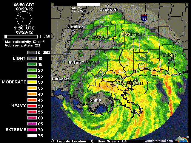
This in from Jeff Lindner:
Hurricane Isaac pounding SE LA and MS with storm surge, strong winds, and flooding rainfall.
Flash Flood Emergency for Plaquemines Parish (east bank). A levee on the E side of the MS River is being overtopped and water levels have rapidly risen to the rooftop of homes from Braithwaite to White Ditch.
Very strong winds currently affecting metro New Orleans with frequent gust to 70mph or greater.
Discussion:
Based on radar the center of hurricane Isaac is on the coast over extreme SE LA just SE of Houma near Terrebonne Bay and is moving WNW at maybe 4 mph…and this may be generous. With the center moving more parallel to the coast than inland, the hurricane has not weakened much overnight and is only expected to slowly weaken given the marshy flat land areas along the southern LA coast. A very slow WNW motion is expected today into tonight has high pressure over the central US builds north and then NE of Isaac blocking its northward motion and trapping the system in weak steering currents. After 36 hours, this high pressure cell should move far enough ESE to allow Isaac to turn toward the N and move toward NW LA and AR.
Based on this thinking Isaac will continue to pound the LA and MS coast for the next 24-30 hours with strong winds, heavy rains, and storm surge. Heavy flooding rainfall and strong winds will spread well inland along the track of Isaac and will begin to affect Baton Rouge later this morning.
Winds:
Some locations on the SE LA coast have now had sustained TS force winds for over 12 hours and another 12-16 hours of strong winds is likely. 300,000 SE LA residents are now without power and expect this will continue to rise as Isaac moves slowly inland. The constant battering of 60-80mph winds for hours and hours will result in somewhat greater damage than usual from a category 1 hurricane especially as the ground saturates allowing trees to up root and topple. 700am winds:
N.O. Airport: 44g67
N.O. Lakefront: 51g64
Slidell: 28g49
Boothville: 43g59
Belle Chase: 36g62
Baton Rouge: 41g58
Gulfport: 35g46
Houma: 39g62
Biloxi: 29g44
Bayou LaBranch: 46g63
Waveland, MS: 46g62
Storm Surge:
Forecasted storm surge values are verifying in the impact area currently.
Listed below are the 630am water levels:
Shell Beach: 10.16ft
Rigolets: 6.40 ft
West End: 5.40 ft
New Canal: 5.04 ft
NO Lakefront: 4.35 ft
Waveland, MS: 7.79ft
As winds turn toward the SE this morning on the east side of SE LA, the storm surge that has piled into Lake Borgne will begin to shift toward the north coast of Lake Borgne and SW MS. Additionally surge will be increasing on the W and N sides of Lake Pontchartrain. Large and dangerous battering waves will accompany the storm surge. Given the large size of the wind field, the storm surge will be slow to recede.
Rainfall:
Radar suggesting 5-7 inches of rain has fallen over SE LA overnight and with the very slow forward motion an additional 10-15 inches of rainfall can be expected. Some total could be as high as 20 inches along and to the right of where the center tracks. Significant potentially life threatening inland freshwater flooding is likely.
Local Impacts:
With the slight westward track overnight, this may bring TS force winds closer to the TX/LA border this afternoon. Expect winds to increase into the 15-25mph range east of I-45 this afternoon with gust to near 30mph. A few feeder bands may rotate westward and impact our area tonight into Thursday as Isaac moves slowly into SC Louisiana.
0 likes