Maybe, IMO.
EPAC: EMILIA - Post-Tropical
Moderator: S2k Moderators
-
Yellow Evan

- Professional-Met

- Posts: 16257
- Age: 27
- Joined: Fri Jul 15, 2011 12:48 pm
- Location: Henderson, Nevada/Honolulu, HI
- Contact:
-
TropicalAnalystwx13

- Category 5

- Posts: 2109
- Age: 28
- Joined: Tue Jul 19, 2011 8:20 pm
- Location: Wilmington, NC
- Contact:
The following post is NOT an official forecast and should not be used as such. It is just the opinion of the poster and may or may not be backed by sound meteorological data. It is NOT endorsed by any professional institution including storm2k.org. For Official Information please refer to the NHC and NWS products.
Upper-level outflow with the storm has blossomed over the past few hours. With a seemingly-endless list of things favoring rapid intensification, we should see a major hurricane by tomorrow night. It would not surprise me in the slightest to see Emilia become a Category 5 on Tuesday.
0 likes
-
TropicalAnalystwx13
- Category 5
- Posts: 2109
- Age: 28
- Joined: Tue Jul 19, 2011 8:20 pm
- Location: Wilmington, NC
- Contact:
00z Best Track:
EP, 05, 2012070900, , BEST, 0, 114N, 1078W, 55, 997, TS
No change in strength.
EP, 05, 2012070900, , BEST, 0, 114N, 1078W, 55, 997, TS
No change in strength.
Last edited by TropicalAnalystwx13 on Sun Jul 08, 2012 7:35 pm, edited 1 time in total.
0 likes
-
Yellow Evan
- Professional-Met
- Posts: 16257
- Age: 27
- Joined: Fri Jul 15, 2011 12:48 pm
- Location: Henderson, Nevada/Honolulu, HI
- Contact:
Re:
TropicalAnalystwx13 wrote:00ZzBest Track:
EP, 05, 2012070900, , BEST, 0, 114N, 1078W, 55, 997, TS
No change in strength.
I was thinking 60 knots, but it has not became much better organized the past few hours, so I am not surprised.
0 likes
-
TropicalAnalystwx13
- Category 5
- Posts: 2109
- Age: 28
- Joined: Tue Jul 19, 2011 8:20 pm
- Location: Wilmington, NC
- Contact:
-
cycloneye

- Admin

- Posts: 149820
- Age: 69
- Joined: Thu Oct 10, 2002 10:54 am
- Location: San Juan, Puerto Rico
Re: EPAC: EMILIA - Tropical Storm
I would have expected a 3.5/3.5 SSD Dvorak number but they are the experts that know how to analize it.
09/0000 UTC 11.4N 107.8W T3.0/3.0 EMILIA -- East Pacific
09/0000 UTC 11.4N 107.8W T3.0/3.0 EMILIA -- East Pacific
0 likes
Visit the Caribbean-Central America Weather Thread where you can find at first post web cams,radars
and observations from Caribbean basin members Click Here
and observations from Caribbean basin members Click Here
-
cycloneye
- Admin
- Posts: 149820
- Age: 69
- Joined: Thu Oct 10, 2002 10:54 am
- Location: San Juan, Puerto Rico
Re: EPAC: EMILIA - Tropical Storm
Way down on the RI SHIP 00z forecast compared with the past three runs.
Prob of RI for 25 kt RI threshold= 39% is 3.3 times the sample mean(11.7%)
Prob of RI for 30 kt RI threshold= 32% is 4.1 times the sample mean( 7.9%)
Prob of RI for 35 kt RI threshold= 28% is 4.9 times the sample mean( 5.4%)
Prob of RI for 40 kt RI threshold= 28% is 9.1 times the sample mean( 3.9%)
ftp://ftp.nhc.noaa.gov/atcf/stext/12070 ... _ships.txt
0 likes
Visit the Caribbean-Central America Weather Thread where you can find at first post web cams,radars
and observations from Caribbean basin members Click Here
and observations from Caribbean basin members Click Here
-
TropicalAnalystwx13
- Category 5
- Posts: 2109
- Age: 28
- Joined: Tue Jul 19, 2011 8:20 pm
- Location: Wilmington, NC
- Contact:

-
Kingarabian

- S2K Supporter

- Posts: 16383
- Joined: Sat Aug 08, 2009 3:06 am
- Location: Honolulu, Hawaii
-
cycloneye
- Admin
- Posts: 149820
- Age: 69
- Joined: Thu Oct 10, 2002 10:54 am
- Location: San Juan, Puerto Rico
Re: EPAC: EMILIA - Tropical Storm
UW - CIMSS
ADVANCED DVORAK TECHNIQUE
ADT-Version 8.1.3
Tropical Cyclone Intensity Algorithm
----- Current Analysis -----
Date : 09 JUL 2012 Time : 003000 UTC
Lat : 11:27:39 N Lon : 107:43:08 W
CI# /Pressure/ Vmax
4.8 / 975.7mb/ 84.8kt
Final T# Adj T# Raw T#
4.4 4.8 4.8
Estimated radius of max. wind based on IR : 9 km
Center Temp : -31.8C Cloud Region Temp : -58.7C
Scene Type : EYE
Positioning Method : SPIRAL ANALYSIS
Ocean Basin : EAST PACIFIC
Dvorak CI > MSLP Conversion Used : PACIFIC
Tno/CI Rules : Constraint Limits : NO LIMIT
Weakening Flag : ON
Rapid Dissipation Flag : OFF
http://tropic.ssec.wisc.edu/real-time/adt/odt05E.html
0 likes
Visit the Caribbean-Central America Weather Thread where you can find at first post web cams,radars
and observations from Caribbean basin members Click Here
and observations from Caribbean basin members Click Here
-
cycloneye
- Admin
- Posts: 149820
- Age: 69
- Joined: Thu Oct 10, 2002 10:54 am
- Location: San Juan, Puerto Rico
Re: EPAC: EMILIA - Tropical Storm
ATCF updated the 00z Best Track increasing to 60kts.
EP, 05, 2012070900, , BEST, 0, 114N, 1078W, 60, 995, TS
ftp://ftp.nhc.noaa.gov/atcf/tcweb/inves ... 012.invest
EP, 05, 2012070900, , BEST, 0, 114N, 1078W, 60, 995, TS
ftp://ftp.nhc.noaa.gov/atcf/tcweb/inves ... 012.invest
0 likes
Visit the Caribbean-Central America Weather Thread where you can find at first post web cams,radars
and observations from Caribbean basin members Click Here
and observations from Caribbean basin members Click Here
-
TropicalAnalystwx13
- Category 5
- Posts: 2109
- Age: 28
- Joined: Tue Jul 19, 2011 8:20 pm
- Location: Wilmington, NC
- Contact:

Re: EPAC: EMILIA - Tropical Storm
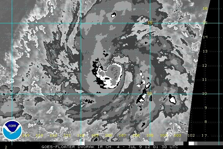
Very strong convection over the center (CDG). Could really ramp up over night.
0 likes
-
TropicalAnalystwx13
- Category 5
- Posts: 2109
- Age: 28
- Joined: Tue Jul 19, 2011 8:20 pm
- Location: Wilmington, NC
- Contact:
TROPICAL STORM EMILIA FORECAST/ADVISORY NUMBER 6
NWS NATIONAL HURRICANE CENTER MIAMI FL EP052012
0300 UTC MON JUL 09 2012
THERE ARE NO COASTAL WATCHES OR WARNINGS IN EFFECT.
TROPICAL STORM CENTER LOCATED NEAR 11.6N 108.4W AT 09/0300Z
POSITION ACCURATE WITHIN 20 NM
PRESENT MOVEMENT TOWARD THE WEST-NORTHWEST OR 285 DEGREES AT 12 KT
ESTIMATED MINIMUM CENTRAL PRESSURE 995 MB
MAX SUSTAINED WINDS 60 KT WITH GUSTS TO 75 KT.
50 KT....... 30NE 20SE 0SW 20NW.
34 KT....... 80NE 50SE 30SW 70NW.
12 FT SEAS.. 90NE 45SE 30SW 90NW.
WINDS AND SEAS VARY GREATLY IN EACH QUADRANT. RADII IN NAUTICAL
MILES ARE THE LARGEST RADII EXPECTED ANYWHERE IN THAT QUADRANT.
REPEAT...CENTER LOCATED NEAR 11.6N 108.4W AT 09/0300Z
AT 09/0000Z CENTER WAS LOCATED NEAR 11.4N 107.8W
FORECAST VALID 09/1200Z 12.1N 110.1W
MAX WIND 70 KT...GUSTS 85 KT.
64 KT... 20NE 0SE 0SW 20NW.
50 KT... 40NE 30SE 20SW 30NW.
34 KT... 80NE 50SE 40SW 70NW.
FORECAST VALID 10/0000Z 12.7N 112.1W
MAX WIND 85 KT...GUSTS 105 KT.
64 KT... 30NE 20SE 20SW 30NW.
50 KT... 50NE 40SE 30SW 40NW.
34 KT...100NE 70SE 60SW 90NW.
FORECAST VALID 10/1200Z 13.3N 114.1W
MAX WIND 95 KT...GUSTS 115 KT.
64 KT... 40NE 30SE 30SW 40NW.
50 KT... 60NE 50SE 40SW 50NW.
34 KT...110NE 80SE 70SW 100NW.
FORECAST VALID 11/0000Z 13.6N 115.8W
MAX WIND 105 KT...GUSTS 130 KT.
50 KT... 60NE 50SE 40SW 60NW.
34 KT...120NE 90SE 80SW 100NW.
FORECAST VALID 12/0000Z 14.2N 119.1W
MAX WIND 100 KT...GUSTS 120 KT.
50 KT... 60NE 50SE 40SW 60NW.
34 KT...120NE 100SE 80SW 110NW.
EXTENDED OUTLOOK. NOTE...ERRORS FOR TRACK HAVE AVERAGED NEAR 150 NM
ON DAY 4 AND 200 NM ON DAY 5...AND FOR INTENSITY NEAR 20 KT EACH DAY
OUTLOOK VALID 13/0000Z 15.0N 123.0W
MAX WIND 80 KT...GUSTS 100 KT.
OUTLOOK VALID 14/0000Z 16.0N 127.5W
MAX WIND 65 KT...GUSTS 80 KT.
REQUEST FOR 3 HOURLY SHIP REPORTS WITHIN 300 MILES OF 11.6N 108.4W
NEXT ADVISORY AT 09/0900Z
$$
FORECASTER BRENNAN
0 likes
-
cycloneye
- Admin
- Posts: 149820
- Age: 69
- Joined: Thu Oct 10, 2002 10:54 am
- Location: San Juan, Puerto Rico
Re: EPAC: EMILIA - Tropical Storm
TROPICAL STORM EMILIA DISCUSSION NUMBER 6
NWS NATIONAL HURRICANE CENTER MIAMI FL EP052012
800 PM PDT SUN JUL 08 2012
GEOSTATIONARY IMAGERY SUGGESTS THAT EMILIA MAY BE IN THE PROCESS OF
FORMING AN EYE...AND A TIMELY 0105 UTC SSMIS PASS CONFIRMS THAT AT
LEAST HALF OF AN EYEWALL HAS FORMED NEAR VERY DEEP CONVECTION EAST
OF THE CENTER. BASED ON THESE IMPROVEMENTS IN CONVECTIVE
STRUCTURE...THE INITIAL INTENSITY IS RAISED TO 60 KT. CONDITIONS
APPEAR FAVORABLE FOR EMILIA TO INTENSIFY STEADILY...IF NOT
RAPIDLY...OVER THE NEXT DAY OR TWO. SHEAR REMAINS LOW AND THE
CYCLONE WILL BE MOVING OVER WATERS WARMER THAN 28C FOR THE NEXT 24
TO 36 HOURS. ADDITIONALLY...AN ENHANCED OUTFLOW CHANNEL HAS FORMED
IN THE NORTHWEST QUADRANT DOWNSTREAM OF THE OUTFLOW OF HURRICANE
DANIEL. THE NHC FORECAST SHOWS EMILIA BECOMING A HURRICANE BY 12
HOURS AND REACHING MAJOR HURRICANE INTENSITY IN ABOUT 2 DAYS...IN
BEST AGREEMENT WITH THE SHIPS MODEL. AFTER 72 HOURS...EMILIA WILL
BE MOVING OVER COOLER SSTS...WHICH SHOULD RESULT IN GRADUAL
WEAKENING AT DAYS 4 AND 5 AS SHOWN BY THE IVCN INTENSITY CONSENSUS.
SATELLITE FIXES SUGGEST THAT EMILIA SLOWED DOWN A LITTLE OVER THE
PAST FEW HOURS...AND THE INITIAL MOTION ESTIMATE IS 285/12. THE
MODEL GUIDANCE IS IN GOOD AGREEMENT SHOWING EMILIA MOVING WEST-
NORTHWESTWARD OVER THE NEXT COUPLE OF DAYS TO THE SOUTH OF A
MID-LEVEL RIDGE. THE NHC FORECAST THROUGH 48 HOURS IS CLOSE TO THE
PREVIOUS ONE AFTER ACCOUNTING FOR THE INITIAL POSITION AND MOTION.
BEYOND THAT TIME...THE MODEL SPREAD INCREASES DUE TO DIFFERENCES IN
HOW MUCH EMILIA WILL FEEL THE INFLUENCE OF AN UPPER-LEVEL TROUGH
MOVING WESTWARD TO THE NORTHWEST OF THE TROPICAL CYCLONE. THE GFS
SHOWS THE MOST INTERACTION AND MORE OF A WEST-NORTHEST MOTION AT
DAY 2 AND BEYOND...AS IT HAS THE DEEPEST REPRESENTATION OF THE
EMILIA VORTEX. AT THE OTHER EXTREME...THE UKMET SHOWS A MUCH
SHALLOWER REPRESENTATION OF EMILIA THAT DOES NOT FEEL THE
INFLUENCE OF THE TROUGH AND THEREFORE MOVES SOUTH OF DUE WEST AFTER
48 HOURS. GIVEN THAT EMILIA IS EXPECTED TO REACH MAJOR HURRICANE
STATUS...SOME INTERACTION WITH THE TROUGH SEEMS LIKELY. THE NEW
NHC FORECAST REFLECTS THAT SCENARIO AND LIES A LITTLE NORTH OF THE
TVCE CONSENSUS AT DAYS 3 THROUGH 5.
FORECAST POSITIONS AND MAX WINDS
INIT 09/0300Z 11.6N 108.4W 60 KT 70 MPH
12H 09/1200Z 12.1N 110.1W 70 KT 80 MPH
24H 10/0000Z 12.7N 112.1W 85 KT 100 MPH
36H 10/1200Z 13.3N 114.1W 95 KT 110 MPH
48H 11/0000Z 13.6N 115.8W 105 KT 120 MPH
72H 12/0000Z 14.2N 119.1W 100 KT 115 MPH
96H 13/0000Z 15.0N 123.0W 80 KT 90 MPH
120H 14/0000Z 16.0N 127.5W 65 KT 75 MPH
$$
FORECASTER BRENNAN
0 likes
Visit the Caribbean-Central America Weather Thread where you can find at first post web cams,radars
and observations from Caribbean basin members Click Here
and observations from Caribbean basin members Click Here
-
cycloneye
- Admin
- Posts: 149820
- Age: 69
- Joined: Thu Oct 10, 2002 10:54 am
- Location: San Juan, Puerto Rico
Re: EPAC: EMILIA - Tropical Storm

0 likes
Visit the Caribbean-Central America Weather Thread where you can find at first post web cams,radars
and observations from Caribbean basin members Click Here
and observations from Caribbean basin members Click Here
-
Kingarabian
- S2K Supporter
- Posts: 16383
- Joined: Sat Aug 08, 2009 3:06 am
- Location: Honolulu, Hawaii
-
cycloneye
- Admin
- Posts: 149820
- Age: 69
- Joined: Thu Oct 10, 2002 10:54 am
- Location: San Juan, Puerto Rico
Re:
Kingarabian wrote:Emilia better make the most of its blessings. Daniel has pretty much moistened up its path. She's in low shear, and really warm waters.
The following post is NOT an official forecast and should not be used as such. It is just the opinion of the poster and may or may not be backed by sound meteorological data. It is NOT endorsed by any professional institution including storm2k.org. For Official Information please refer to the NHC and NWS products.
It has all the factors in favor including help from Daniel's outflow that has created a channel for her to go bonkers so to speak. Let's see in reallity how she works with all of that. My peak intensity is 125kts.
0 likes
Visit the Caribbean-Central America Weather Thread where you can find at first post web cams,radars
and observations from Caribbean basin members Click Here
and observations from Caribbean basin members Click Here
-
brunota2003

- S2K Supporter
- Posts: 9476
- Age: 35
- Joined: Sat Jul 30, 2005 9:56 pm
- Location: Stanton, KY...formerly Havelock, NC
- Contact:
Re:
Personal Forecast Disclaimer:
The posts in this forum are NOT official forecast and should not be used as such. They are just the opinion of the poster and may or may not be backed by sound meteorological data. They are NOT endorsed by any professional institution or storm2k.org. For official information, please refer to the NHC and NWS products.
brunota2003 wrote:Personal Forecast Disclaimer:
The posts in this forum are NOT official forecast and should not be used as such. They are just the opinion of the poster and may or may not be backed by sound meteorological data. They are NOT endorsed by any professional institution or storm2k.org. For official information, please refer to the NHC and NWS products.
Well...looking through the latest, RI may begin within the next 6 to 10 hours. I really don't have time to work with (sitting in an airport), so I'm just going to throw a quick guess out there...90 knots by 11 am tomorrow morning (going to start the 24 hours at 11 am). We'll see how close I am!
Could a mod add the disclaimer? Thanks.
Well, on a computer so I can post a little more now (dial up though...yayy lol).
I'm still sticking with 90 knots by the 11 am advisory, however I believe the real RI is just about to begin. Looking through the latest and greatest, the main RI should begin between 2 and 4 am...and I expect that by the 11 pm advisory tomorrow, Emilia will be pushing 110 or 115 knots. After that, the intensification will slow down...and I can see a peak of 125 or 130 knots.
0 likes
Just a small town southern boy helping other humans.
-
Yellow Evan
- Professional-Met
- Posts: 16257
- Age: 27
- Joined: Fri Jul 15, 2011 12:48 pm
- Location: Henderson, Nevada/Honolulu, HI
- Contact:
Who is online
Users browsing this forum: No registered users and 6 guests