ATL: ALBERTO - Post-Tropical
Moderator: S2k Moderators
-
Aric Dunn
- Category 5

- Posts: 21238
- Age: 43
- Joined: Sun Sep 19, 2004 9:58 pm
- Location: Ready for the Chase.
- Contact:
after a little analysis. appears the center is already approaching the 12 hour forecast position. around 32N well removed from the convection .
0 likes
Note: If I make a post that is brief. Please refer back to previous posts for the analysis or reasoning. I do not re-write/qoute what my initial post said each time.
If there is nothing before... then just ask
Space & Atmospheric Physicist, Embry-Riddle Aeronautical University,
I believe the sky is falling...
If there is nothing before... then just ask
Space & Atmospheric Physicist, Embry-Riddle Aeronautical University,
I believe the sky is falling...
-
stormhunter7

- Category 2

- Posts: 763
- Joined: Mon May 26, 2008 3:13 pm
- Location: Panama City Beach, Florida
- Contact:
Re: ATL: ALBERTO - Tropical Storm
here's a few things i over laid on radar... very compact storm
http://imageshack.us/photo/my-images/832/albertoy.png/
http://imageshack.us/photo/my-images/832/albertoy.png/
Last edited by stormhunter7 on Sat May 19, 2012 7:20 pm, edited 2 times in total.
0 likes
The following post is NOT an official forecast and should not be used as such. It is just the opinion of the poster and may or may not be backed by sound meteorological data. It is NOT endorsed by any professional institution including storm2k.org For Official Information please refer to the NHC and NWS products. http://www.nhc.noaa.gov
-
ouragans

- Category 2
- Posts: 504
- Age: 54
- Joined: Sun Jun 12, 2011 12:09 pm
- Location: Abymes, Guadeloupe F.W.I
- Contact:
Re: ATL: ALBERTO - Advisory Thread
BULLETIN
TROPICAL STORM ALBERTO ADVISORY NUMBER 1
NWS NATIONAL HURRICANE CENTER MIAMI FL AL012012
500 PM EDT SAT MAY 19 2012
...FIRST TROPICAL STORM OF THE ATLANTIC SEASON FORMS OFF THE COAST
OF SOUTH CAROLINA...
SUMMARY OF 500 PM EDT...2100 UTC...INFORMATION
----------------------------------------------
LOCATION...32.2N 77.7W
ABOUT 140 MI...225 KM ESE OF CHARLESTON SOUTH CAROLINA
ABOUT 120 MI...190 KM S OF CAPE FEAR NORTH CAROLINA
MAXIMUM SUSTAINED WINDS...45 MPH...75 KM/H
PRESENT MOVEMENT...SW OR 220 DEGREES AT 3 MPH...6 KM/H
MINIMUM CENTRAL PRESSURE...1007 MB...29.74 INCHES
WATCHES AND WARNINGS
--------------------
THERE ARE NO COASTAL WATCHES OR WARNINGS IN EFFECT.
A TROPICAL STORM WATCH MAY BE NEEDED FOR A PORTION OF THE COAST OF
THE CAROLINAS TONIGHT.
DISCUSSION AND 48-HOUR OUTLOOK
------------------------------
AT 500 PM EDT...2100 UTC...THE CENTER OF TROPICAL STORM ALBERTO WAS
LOCATED NEAR LATITUDE 32.2 NORTH...LONGITUDE 77.7 WEST. ALBERTO IS
MOVING TOWARD THE SOUTHWEST NEAR 3 MPH...6 KM/H...AND A SLOW
SOUTHWESTWARD MOTION IS EXPECTED TO CONTINUE THROUGH SUNDAY. A
TURN TOWARD THE WEST-NORTHWEST AND THEN TOWARD THE NORTH AND
NORTHEAST IS EXPECTED BY MONDAY.
MAXIMUM SUSTAINED WINDS ARE NEAR 45 MPH...75 KM/H...WITH HIGHER
GUSTS. SOME STRENGTHENING IS POSSIBLE OVER THE NEXT DAY OR SO.
TROPICAL STORM FORCE WINDS EXTEND OUTWARD UP TO 45 MILES...75 KM
FROM THE CENTER.
ESTIMATED MINIMUM CENTRAL PRESSURE IS 1007 MB...29.74 INCHES.
HAZARDS AFFECTING LAND
----------------------
NONE
NEXT ADVISORY
-------------
NEXT COMPLETE ADVISORY...1100 PM EDT.
$$
FORECASTER BRENNAN
0 likes
Personal forecast disclaimer
This post is a personal point of view, not an information. Please refer to official statements for life-threatening decisions.
David '79, Frederic '79, Hugo '89, Iris, Luis & Marilyn '95, Georges '98, Lenny '99, Dean '07, Irma '17, Maria '17, Fiona '22, Philippe '23, Tammy '23
16°13'33.3,"6N -61°36'39.5"W
-
ouragans
- Category 2
- Posts: 504
- Age: 54
- Joined: Sun Jun 12, 2011 12:09 pm
- Location: Abymes, Guadeloupe F.W.I
- Contact:
Re: ATL: ALBERTO - Advisory Thread
TROPICAL STORM ALBERTO TROPICAL CYCLONE UPDATE
NWS NATIONAL HURRICANE CENTER MIAMI FL AL012012
650 PM EDT SAT MAY 19 2012
...SHIP INDICATES ALBERTO IS STRONGER...
REPORTS FROM A SHIP NEAR THE CENTER OF ALBERTO INDICATE THAT THE
CYCLONE IS STRONGER THAN PREVIOUSLY ESTIMATED. BASED PRIMARILY ON
THE PRESSURE DATA...MAXIMUM SUSTAINED WINDS ARE NOW ESTIMATED TO BE
60 MPH...95 KM/H. LITTLE CHANGE IN STRENGTH IS EXPECTED OVER THE
NEXT COUPLE OF DAYS AND NO CHANGES TO THE OFFICIAL FORECAST ARE
REQUIRED AT THIS TIME.
SUMMARY OF 650 PM...2250 UTC...INFORMATION
--------------------------------------------------
LOCATION...32.2N 77.9W
ABOUT 130 MI...210 KM ESE OF CHARLESTON SOUTH CAROLINA
ABOUT 120 MI...190 KM S OF CAPE FEAR NORTH CAROLINA
MAXIMUM SUSTAINED WINDS...60 MPH...95 KM/H
PRESENT MOVEMENT...SW OR 220 DEGREES AT 3 MPH...6 KM/H
MINIMUM CENTRAL PRESSURE...995 MB...29.38 INCHES
$$
FORECASTER BLAKE/FRANKLIN
0 likes
Personal forecast disclaimer
This post is a personal point of view, not an information. Please refer to official statements for life-threatening decisions.
David '79, Frederic '79, Hugo '89, Iris, Luis & Marilyn '95, Georges '98, Lenny '99, Dean '07, Irma '17, Maria '17, Fiona '22, Philippe '23, Tammy '23
16°13'33.3,"6N -61°36'39.5"W
This post is a personal point of view, not an information. Please refer to official statements for life-threatening decisions.
David '79, Frederic '79, Hugo '89, Iris, Luis & Marilyn '95, Georges '98, Lenny '99, Dean '07, Irma '17, Maria '17, Fiona '22, Philippe '23, Tammy '23
16°13'33.3,"6N -61°36'39.5"W
-
Dean4Storms
- S2K Supporter

- Posts: 6358
- Age: 63
- Joined: Sun Aug 31, 2003 1:01 pm
- Location: Miramar Bch. FL
Tropical Storm Watch parts of SC Coast.......Note, for the waters out 20NM!
http://forecast.weather.gov/wwamap/wwat ... rm%20watch
http://forecast.weather.gov/wwamap/wwat ... rm%20watch
0 likes
-
ozonepete
- Professional-Met

- Posts: 4743
- Joined: Mon Sep 07, 2009 3:23 pm
- Location: From Ozone Park, NYC / Now in Brooklyn, NY
Re: ATL: ALBERTO - Tropical Storm
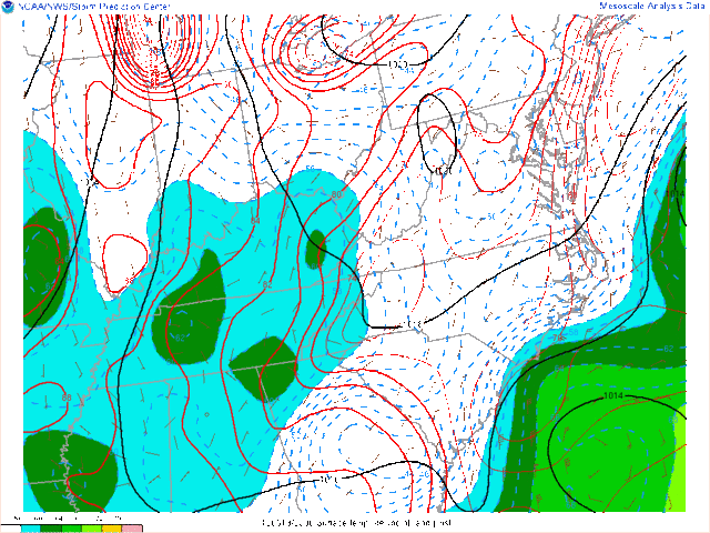
Boy this sure caught me off guard! Fast little developer. Anyway, it seems it will have to maintain its small size for at least the next day or so to survive. Here's the SPC RUC analysis for 2300 UTC. Look at all of that dry air! Max dewpoints of 64-68 where the core is? Man is that low. And a wall of dry air to the west and north. If it doesn't expand much for the time being it should be ok. But should the wind field start expanding it will draw in a large amount of that dry air and the thunderstorms will collapse really quickly. This is also a headache for the models because it's so small. They are going to have a hard time resolving such a small mesoscale feature.
Color key for dewpoints:

Color key for dewpoints:
0 likes
-
Stephanie

- S2K Supporter
- Posts: 23843
- Age: 63
- Joined: Thu Feb 06, 2003 9:53 am
- Location: Glassboro, NJ
Re: ATL: ALBERTO - Tropical Storm
Jevo wrote:I was hoping not to see you folks for a few more weeks.. Welcome to HS2012..
Albie is looking a sad right now, but all in all it warrants a
http://i29.photobucket.com/albums/c290/hausjm/jsoa.png
Mannn I dont even have my Publix hurricane tracking map yet
LOL! Like that stamp of approval!
Local news mets have been showing the storm on radar the last few days and I was wondering if it was going to develop. It had a nice little circulation on doplar radar a day or so ago. What blows my mind is that it's off the SE coast BEFORE the season even started.
0 likes
-
ozonepete
- Professional-Met
- Posts: 4743
- Joined: Mon Sep 07, 2009 3:23 pm
- Location: From Ozone Park, NYC / Now in Brooklyn, NY
Re: ATL: ALBERTO - Tropical Storm
Hi Stephanie! I don't watch local mets anymore, but maybe I should have been, lol.
Jevo - love your stamp too!
Jevo - love your stamp too!
0 likes
-
hurricanefloyd5

- Category 5
- Posts: 1659
- Age: 45
- Joined: Sun May 02, 2004 10:53 am
- Location: Spartanburg
- Contact:
Re: ATL: ALBERTO - Tropical Storm
http://radar.weather.gov/radar.php?prod ... x&loop=yes Looks like the center of the storm is east of SAVANNA,GA
0 likes
-
brunota2003

- S2K Supporter
- Posts: 9476
- Age: 35
- Joined: Sat Jul 30, 2005 9:56 pm
- Location: Stanton, KY...formerly Havelock, NC
- Contact:

WOW
This is one of the most surprising things to happen in the tropics in years!!! Now that is something that is hard to accomplish since anything can happen in the the tropics plus the expression "expect the unexpected". The NHC didn't even have an area highlighted before morning and then less than 10 hours later a TS???!? When was the last time? 
I see it became an Invest just after I signed off, models didn't show this until later so it never crossed my mind. Now the Epac and Atlantic both have pre-season storms and the earliest since Ana in April 2003. When was the last time a May TC formed in the Atlantic before this date?
This could further surprise us all if it totally gets rid of any remaining non-tropical characteristics...even though its almost there (deemed tropical). Its pretty small and very close to the Gulf stream, this could strengthen faster than forecast and as unlikely as it seems, does have a chance IMO of becoming a hurricane. Wouldn't it be something if it is that strong while targeting New England while there is a severe weather outbreak occurring on the plains? Continue to add to that, a major hurricane in the Epac with a weak TS, a minor warm up during and you have the complete package.
0 likes
-
brunota2003
- S2K Supporter
- Posts: 9476
- Age: 35
- Joined: Sat Jul 30, 2005 9:56 pm
- Location: Stanton, KY...formerly Havelock, NC
- Contact:
ATL: ALBERTO - Recon
For any future recon flights...NHC said that they are flying tomorrow afternoon, but didn't go any further into detail.
Last edited by brunota2003 on Sun May 20, 2012 4:20 pm, edited 5 times in total.
0 likes
Just a small town southern boy helping other humans.
-
cycloneye

- Admin

- Posts: 149826
- Age: 69
- Joined: Thu Oct 10, 2002 10:54 am
- Location: San Juan, Puerto Rico
Re: ATL: ALBERTO - Tropical Storm
Crazy, you nailed it as ATCF fixed the 18z best track as they increased intensity to 45kts. At 00z is up to 50kts.
AL, 01, 2012051918, , BEST, 0, 323N, 776W, 45, 1000, TS
00z Best Track
AL, 01, 2012052000, , BEST, 0, 322N, 780W, 50, 995, TS
http://ftp.nhc.noaa.gov/atcf/tcweb/inve ... 012.invest
AL, 01, 2012051918, , BEST, 0, 323N, 776W, 45, 1000, TS
00z Best Track
AL, 01, 2012052000, , BEST, 0, 322N, 780W, 50, 995, TS
http://ftp.nhc.noaa.gov/atcf/tcweb/inve ... 012.invest
0 likes
Visit the Caribbean-Central America Weather Thread where you can find at first post web cams,radars
and observations from Caribbean basin members Click Here
and observations from Caribbean basin members Click Here

Re: ATL: ALBERTO - Models
This formed out of the recent trough and historically those type storms drift south some in the dry flow behind the front but if they don't get below 28-29 degrees the next short wave usually sweeps them back northeast.
0 likes
-
cycloneye
- Admin
- Posts: 149826
- Age: 69
- Joined: Thu Oct 10, 2002 10:54 am
- Location: San Juan, Puerto Rico
Re: ATL: ALBERTO - Models
00z Tropical Models
TROPICAL CYCLONE GUIDANCE MESSAGE
NWS NATIONAL HURRICANE CENTER MIAMI FL
0027 UTC SUN MAY 20 2012
DISCLAIMER...NUMERICAL MODELS ARE SUBJECT TO LARGE ERRORS.
PLEASE REFER TO NHC OFFICIAL FORECASTS FOR TROPICAL CYCLONE
AND SUBTROPICAL CYCLONE INFORMATION.
ATLANTIC OBJECTIVE AIDS FOR
TROPICAL CYCLONE ALBERTO (AL012012) 20120520 0000 UTC
...00 HRS... ...12 HRS... ...24 HRS. .. ...36 HRS...
120520 0000 120520 1200 120521 0000 120521 1200
LAT LON LAT LON LAT LON LAT LON
BAMS 32.2N 78.0W 32.0N 79.0W 31.5N 80.1W 31.0N 80.6W
BAMD 32.2N 78.0W 33.1N 77.7W 33.9N 78.1W 34.4N 78.4W
BAMM 32.2N 78.0W 32.4N 78.7W 32.5N 79.5W 32.4N 79.9W
LBAR 32.2N 78.0W 32.9N 77.9W 33.8N 77.8W 34.8N 77.5W
SHIP 50KTS 54KTS 57KTS 58KTS
DSHP 50KTS 54KTS 57KTS 58KTS
...48 HRS... ...72 HRS... ...96 HRS. .. ..120 HRS...
120522 0000 120523 0000 120524 0000 120525 0000
LAT LON LAT LON LAT LON LAT LON
BAMS 30.8N 79.7W 32.9N 74.8W 36.2N 70.3W 38.2N 69.7W
BAMD 35.3N 77.2W 38.7N 69.4W 40.8N 55.9W 39.3N 41.8W
BAMM 33.0N 78.4W 37.2N 70.5W 40.2N 57.5W 39.3N 41.7W
LBAR 36.8N 76.7W 40.7N 71.8W 43.2N 60.9W .0N .0W
SHIP 60KTS 61KTS 58KTS 49KTS
DSHP 60KTS 61KTS 58KTS 49KTS
...INITIAL CONDITIONS...
LATCUR = 32.2N LONCUR = 78.0W DIRCUR = 230DEG SPDCUR = 3KT
LATM12 = 32.5N LONM12 = 77.3W DIRM12 = 215DEG SPDM12 = 4KT
LATM24 = 33.1N LONM24 = 76.8W
WNDCUR = 50KT RMAXWD = 15NM WNDM12 = 40KT
CENPRS = 995MB OUTPRS = 1013MB OUTRAD = 50NM SDEPTH = M
RD34NE = 40NM RD34SE = 0NM RD34SW = 30NM RD34NW = 40NM
0 likes
Visit the Caribbean-Central America Weather Thread where you can find at first post web cams,radars
and observations from Caribbean basin members Click Here
and observations from Caribbean basin members Click Here
-
brunota2003
- S2K Supporter
- Posts: 9476
- Age: 35
- Joined: Sat Jul 30, 2005 9:56 pm
- Location: Stanton, KY...formerly Havelock, NC
- Contact:
Watch this buoy, as it is starting to get into the western side of the rain shield of TS Alberto:
http://www.ndbc.noaa.gov/station_page.php?station=41004
http://www.ndbc.noaa.gov/station_page.php?station=41004
0 likes
Just a small town southern boy helping other humans.
-
brunota2003
- S2K Supporter
- Posts: 9476
- Age: 35
- Joined: Sat Jul 30, 2005 9:56 pm
- Location: Stanton, KY...formerly Havelock, NC
- Contact:
-
CrazyC83
- Professional-Met
- Posts: 34316
- Joined: Tue Mar 07, 2006 11:57 pm
- Location: Deep South, for the first time!
So how intense is Alberto really? The only data from near the core we have is that ship which had 1000mb and 65 kt winds (central pressure 993mb if that is accurate), but it is not likely 65 kt. Still, if Recon finds big stuff tomorrow, they might call that representative and give it a post-season upgrade?
0 likes
Who is online
Users browsing this forum: No registered users and 16 guests