CI# /Pressure/ Vmax
4.8 / 970.7mb/ 84.8kt
Final T# Adj T# Raw T#
4.8 4.8 6.3
TXPQ28 KNES 160318
TCSWNP
A. 05W (GUCHOL)
B. 16/0232Z
C. 13.5N
D. 129.9E
E. ONE/MTSAT
F. T6.0/6.0/D1.0/24HRS
G. IR/EIR/VIS
H. REMARKS... LG EYE SURROUNDED AND EMBEDDED IN W FOR DT=6.0. MET AND
PT AGREE. FT IS BASED ON DT.
I. ADDL POSITIONS
NIL
...SALEMI
supports a category 4! j
WPAC: GUCHOL - Post-Tropical
Moderator: S2k Moderators
-
francis327
- WesternPacificWeather.com

- Posts: 81
- Joined: Mon Nov 07, 2011 9:04 am
- Location: Kuala Lumpur, Malaysia
- Contact:
Re: WPAC: GUCHOL - Typhoon 05W
Dvorak T4.5 from the JMA
WTPQ20 RJTD 160300
RSMC TROPICAL CYCLONE ADVISORY
NAME TY 1204 GUCHOL (1204)
ANALYSIS
PSTN 160300UTC 13.4N 129.9E GOOD
MOVE NNW 10KT
PRES 965HPA
MXWD 070KT
GUST 100KT
50KT 50NM
30KT 200NM
FORECAST
24HF 170300UTC 17.7N 127.5E 75NM 70%
MOVE NNW 12KT
PRES 950HPA
MXWD 080KT
GUST 115KT
45HF 180000UTC 20.9N 127.0E 140NM 70%
MOVE N 11KT
PRES 940HPA
MXWD 085KT
GUST 120KT
69HF 190000UTC 25.4N 128.2E 250NM 70%
MOVE N 12KT
PRES 945HPA
MXWD 080KT
GUST 115KT =
0 likes
WESTERNPACIFICWEATHER.COM


-
euro6208
Re: WPAC: GUCHOL - Typhoon 05W

continuing to strengthen....category 4 in my eyes already...
based on all available data, i would place the intensity at 115 knots category 4 1 min...knowing JTWC, they will most likely be on the low side when dvorak says otherwise...
The posts in this forum are NOT official forecast and should not be used as such. They are just the opinion of the poster and may or may not be backed by sound meteorological data. They are NOT endorsed by any professional institution or storm2k.org. For official information, please refer to the JTWC and JMA products.
0 likes
-
francis327
- WesternPacificWeather.com
- Posts: 81
- Joined: Mon Nov 07, 2011 9:04 am
- Location: Kuala Lumpur, Malaysia
- Contact:
A small request, is anyone kind enough to provide me a link to JMA Dvorak reading page? The best I can get is from http://www.wunderground.com/blog/HadesG ... commenttop
Any assistance would be appreciated.
Thanks
Any assistance would be appreciated.
Thanks
0 likes
WESTERNPACIFICWEATHER.COM
85 knots now from JMA.
WTPQ20 RJTD 160600
RSMC TROPICAL CYCLONE ADVISORY
NAME TY 1204 GUCHOL (1204)
ANALYSIS
PSTN 160600UTC 14.0N 129.6E GOOD
MOVE NNW 12KT
PRES 950HPA
MXWD 085KT
GUST 120KT
50KT 50NM
30KT 200NM
FORECAST
24HF 170600UTC 18.3N 127.3E 75NM 70%
MOVE NNW 12KT
PRES 940HPA
MXWD 090KT
GUST 130KT
48HF 180600UTC 23.4N 127.7E 180NM 70%
MOVE N 13KT
PRES 940HPA
MXWD 090KT
GUST 130KT
72HF 190600UTC 28.4N 130.3E 250NM 70%
MOVE NNE 14KT
PRES 950HPA
MXWD 080KT
GUST 115KT =
0 likes
The JMA's SAREPs (satellite reports) are encoded in BUFR format.
You can find them here but it's useless without a BUFR reader.
Also suggest you follow the official advisories at http://www.jma.go.jp/en/typh/ than something someone's "translated". You'll find no mention of "categories" on the JMA page, compared to the link you gave.
You can find them here but it's useless without a BUFR reader.
Also suggest you follow the official advisories at http://www.jma.go.jp/en/typh/ than something someone's "translated". You'll find no mention of "categories" on the JMA page, compared to the link you gave.
0 likes
-
francis327
- WesternPacificWeather.com
- Posts: 81
- Joined: Mon Nov 07, 2011 9:04 am
- Location: Kuala Lumpur, Malaysia
- Contact:
Re:
Chacor wrote:The JMA's SAREPs (satellite reports) are encoded in BUFR format.
You can find them here but it's useless without a BUFR reader.
Also suggest you follow the official advisories at http://www.jma.go.jp/en/typh/ than something someone's "translated". You'll find no mention of "categories" on the JMA page, compared to the link you gave.
Thanks Chacor, I subscribe the RSS feed from WIS Portal -Tropical Cyclone Page so ya I have 3 hourly updates from RSMC Japan. Just that a Dvorak reading might as well good enough since I am doing a Storm Tracking Summary for my site.
Thanks again for the kind help.
0 likes
WESTERNPACIFICWEATHER.COM


Re: WPAC: GUCHOL - Typhoon 05W
Classic.
0 likes
NOTICE: I cannot give an expert analysis. Most of my "observations" are made visually with the help of only vital information provided by public advisories.

Re: WPAC: GUCHOL - Typhoon 05W
This storm is picture perfect, isn't it? Thank God I'm no longer a storm newbie or I'd be making a mess in my pants right about now. The scramble to prepare for the storm has already begun with Americans on the bases. The Okinawans still haven't started the mad dash, yet. They never do until the last minute, though, when there is without a reasonable doubt that it will hit us. I do believe this could be the biggest storm we've seen in our 3 years here.
0 likes
-
senorpepr

- Military Met/Moderator

- Posts: 12542
- Age: 43
- Joined: Fri Aug 22, 2003 9:22 pm
- Location: Mackenbach, Germany
- Contact:
Re:
Chacor wrote:The JMA's SAREPs (satellite reports) are encoded in BUFR format.
You can find them here but it's useless without a BUFR reader.
Also suggest you follow the official advisories at http://www.jma.go.jp/en/typh/ than something someone's "translated". You'll find no mention of "categories" on the JMA page, compared to the link you gave.
I didn't realize the alphanumeric FM-85 SAREP was discontinued by JMA at the end of 2010. (Personal opinion: I'm not a fan of moving everything to BUFR format, as suggested by the WMO) That said, would you suggest a specific viewer for viewing BUFR?
0 likes
There are a few open-source ones listed at the Wikipedia article on BUFR, but I've never been able to get any of them to work. The ECMWF have a BUFR format verifying area which is usable (though inconvenient) as a 'cheat' to read them. That's why I usually don't bother looking at JMA SAREPs unless an upgrade seems imminent.
Last edited by Chacor on Sat Jun 16, 2012 3:25 am, edited 2 times in total.
0 likes
-
Typhoon Hunter
- WesternPacificWeather.com
- Posts: 1222
- Joined: Wed Oct 11, 2006 11:37 am
- Location: Tokyo
- Contact:
-
phwxenthusiast
- Category 2

- Posts: 637
- Joined: Wed Mar 24, 2010 3:10 am
- Location: Holbrook, NY (Long Island)
Re:
Typhoon Hunter wrote:Well on its way to become "super" if not already. The Philippines Sea never fails to impress!
are you going to Okinawa now?? hehe JTWC now expecting a possible super by the time it passes near the island... based on the latest tracks, though, it seems it'll move east of Okinawa so you probably won't see the strongest winds...
0 likes
-
P.K.

- Professional-Met

- Posts: 5149
- Joined: Thu Sep 23, 2004 5:57 pm
- Location: Watford, England
- Contact:
Re: WPAC: GUCHOL - Typhoon 05W
Yeah the CMA don't look too far off an upgrade.
WTPQ20 BABJ 160600
SUBJECTIVE FORECAST
STY GUCHOL 1204 (1204) INITIAL TIME 160600 UTC
00HR 14.0N 129.5E 950HPA 45M/S
30KTS 260KM
50KTS 110KM
P12HR NW 24KM/H
P+24HR 18.6N 127.1E 935HPA 55M/S
P+48HR 23.0N 127.2E 940HPA 52M/S
P+72HR 28.5N 130.2E 960HPA 40M/S
P+96HR 34.7N 138.0E 975HPA 30M/S
P+120HR 38.5N 150.6E 990HPA 18M/S=
0 likes
-
Typhoon Hunter
- WesternPacificWeather.com
- Posts: 1222
- Joined: Wed Oct 11, 2006 11:37 am
- Location: Tokyo
- Contact:
No, if it passes even a few miles to the east of Okinawa it won't be worth filming so unless there's a shift westward slightly in forecast track / models I won't be going anywhere. Beside we're getting lashed by Invest 92W which looks like it could become a tropical depression in a day or so! 
0 likes
-
senorpepr
- Military Met/Moderator
- Posts: 12542
- Age: 43
- Joined: Fri Aug 22, 2003 9:22 pm
- Location: Mackenbach, Germany
- Contact:
Re:
Chacor wrote:There are a few open-source ones listed at the Wikipedia article on BUFR, but I've never been able to get any of them to work. The ECMWF have a BUFR format verifying area which is usable (though inconvenient) as a 'cheat' to read them. That's why I usually don't bother looking at JMA SAREPs unless an upgrade seems imminent.
Which is exactly my point on why I dislike the WMO pushing for BUFR. In some places it's good, but informational products (such as SAREPs) should remain in the format outlined in WMO Vol 306... in my opinion.
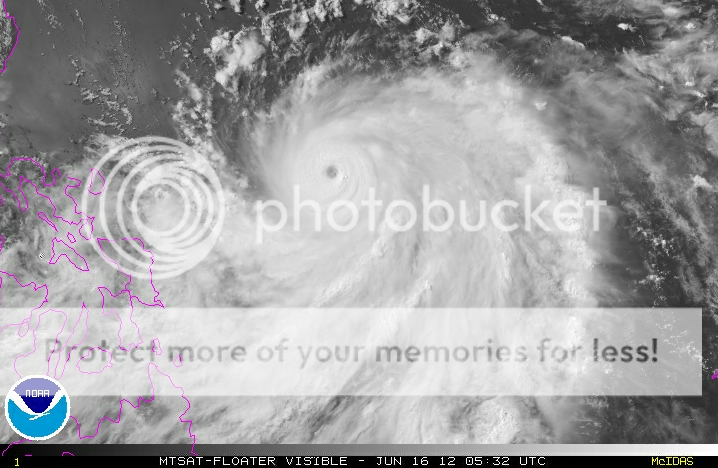
Guchol looking good now:

I did a Dvorak analysis and also came up with a T6.5, as did JTWC. Large white band (with a small pocket of cold, medium grey) surrounding an off-white eye. Central feature was 6.5. I opted to go without the banding feature (as did JTWC), but there is a light grey banding "wedge" extending from the SE quad. Nonetheless, T6.5 as a DT seems very reasonable. (Although I could see the case of T7.0 considering a +0.5 for the banding feature). This is in general agreement with ADT, which had a raw T6.7 and a Final T6.3 (122 kt 936 hPa). JTWC also mentioned a crazy D2.0 for the Model-T. ADT has raised the constraints to T1.7/6hrs. Rapid intensification going on here...
0 likes
-
Typhoon Hunter
- WesternPacificWeather.com
- Posts: 1222
- Joined: Wed Oct 11, 2006 11:37 am
- Location: Tokyo
- Contact:
Re: WPAC: GUCHOL - Typhoon 05W
Great analysis, srpepr! Thank you. WPAC already racking up the T numbers. Looking like we might be spared some of the brunt of the storm if latest track forecasts are correct.
0 likes
Who is online
Users browsing this forum: No registered users and 87 guests