Up to 50%!
TROPICAL WEATHER OUTLOOK
NWS NATIONAL HURRICANE CENTER MIAMI FL
200 PM EDT MON JUN 18 2012
FOR THE NORTH ATLANTIC...CARIBBEAN SEA AND THE GULF OF MEXICO...
THUNDERSTORM ACTIVITY ASSOCIATED WITH A SMALL NON-TROPICAL LOW
PRESSURE CENTER HAS BECOME BETTER ORGANIZED TODAY. THIS SYSTEM IS
PRODUCING GALE-FORCE WINDS AND IS LOCATED ABOUT 400 MILES
NORTH-NORTHEAST OF BERMUDA. THE LOW HAS GRADUALLY BEEN ACQUIRING
TROPICAL CHARACTERISTICS AND IF THE THUNDERSTORM ACTIVITY PERSISTS
IT COULD BECOME A SUBTROPICAL OR TROPICAL CYCLONE LATER TODAY OR
TUESDAY. THIS SYSTEM HAS A MEDIUM CHANCE...50 PERCENT...OF
BECOMING A SUBTROPICAL OR TROPICAL CYCLONE DURING THE NEXT 48 HOURS
AS IT MOVES NORTHEASTWARD AT AROUND 10 MPH. FOR ADDITIONAL
INFORMATION ON THIS SYSTEM...PLEASE SEE HIGH SEAS FORECASTS ISSUED
BY THE NATIONAL WEATHER SERVICE OCEAN PREDICTION CENTER.
ELSEWHERE...TROPICAL CYCLONE FORMATION IS NOT EXPECTED DURING THE
NEXT 48 HOURS.
&&
HIGH SEAS FORECASTS ISSUED BY THE NATIONAL WEATHER SERVICE CAN BE
FOUND UNDER AWIPS HEADER NFDHSFAT1 AND WMO HEADER FZNT01 KWBC.
$$
FORECASTER LANDSEA
ATL: CHRIS - Post-Tropical
Moderator: S2k Moderators
-
TropicalAnalystwx13

- Category 5

- Posts: 2109
- Age: 28
- Joined: Tue Jul 19, 2011 8:20 pm
- Location: Wilmington, NC
- Contact:
-
tolakram
- Admin

- Posts: 20188
- Age: 62
- Joined: Sun Aug 27, 2006 8:23 pm
- Location: Florence, KY (name is Mark)
Re: ATL: INVEST 95L

0 likes
M a r k
- - - - -
Join us in chat: Storm2K Chatroom Invite. Android and IOS apps also available.
The posts in this forum are NOT official forecasts and should not be used as such. Posts are NOT endorsed by any professional institution or STORM2K.org. For official information and forecasts, please refer to NHC and NWS products.
-
Aric Dunn
- Category 5
- Posts: 21238
- Age: 43
- Joined: Sun Sep 19, 2004 9:58 pm
- Location: Ready for the Chase.
- Contact:
some shallow but recent convection has redeveloped and should be enough if it can maintain for a few more hours or till 11 for a upgrade to probably sub tropical since its over 23 to 24c ssts if it can mantain slightly deeper convection then maybe full tropical tomorrow.
0 likes
Note: If I make a post that is brief. Please refer back to previous posts for the analysis or reasoning. I do not re-write/qoute what my initial post said each time.
If there is nothing before... then just ask
Space & Atmospheric Physicist, Embry-Riddle Aeronautical University,
I believe the sky is falling...
If there is nothing before... then just ask
Space & Atmospheric Physicist, Embry-Riddle Aeronautical University,
I believe the sky is falling...
-
TropicalAnalystwx13
- Category 5
- Posts: 2109
- Age: 28
- Joined: Tue Jul 19, 2011 8:20 pm
- Location: Wilmington, NC
- Contact:


Oh wow. Even if this system doesn't get designated (and I think it looks well enough to easily become a (sub?) tropical storm), what an amazing start. Three systems before July seem likely at this point.
0 likes
I'm no expert, everything I say should be taken with a large amount of salt. I could easily be very, very wrong.
~Zanthe Go Coyotes~
~Zanthe Go Coyotes~
-
MGC

- S2K Supporter

- Posts: 5941
- Joined: Sun Mar 23, 2003 9:05 pm
- Location: Pass Christian MS, or what is left.
Re: ATL: INVEST 95L
95L has got much better organized today. If it continues this organization trend I would not be suprized if 95L is named......MGC
0 likes
-
cycloneye

- Admin
- Posts: 149813
- Age: 69
- Joined: Thu Oct 10, 2002 10:54 am
- Location: San Juan, Puerto Rico
Re: ATL: INVEST 95L
Up to 60%
TROPICAL WEATHER OUTLOOK
NWS NATIONAL HURRICANE CENTER MIAMI FL
800 PM EDT MON JUN 18 2012
FOR THE NORTH ATLANTIC...CARIBBEAN SEA AND THE GULF OF MEXICO...
SHOWERS AND THUNDERSTORMS ASSOCIATED WITH A NON-TROPICAL LOW
LOCATED ABOUT 480 MILES NORTH-NORTHEAST OF BERMUDA HAVE CHANGED
LITTLE IN ORGANIZATION THIS EVENING. HOWEVER...THE SYSTEM
CONTINUES TO GENERATE GALE-FORCE WINDS...AND ANY INCREASE IN THE
ORGANIZATION OF SHOWER AND THUNDERSTORM ACTIVITY NEAR THE CENTER
WOULD RESULT IN THE FORMATION OF A TROPICAL OR SUBTROPICAL STORM.
THIS SYSTEM HAS A HIGH CHANCE...60 PERCENT...OF BECOMING A TROPICAL
OR SUBTROPICAL CYCLONE DURING THE NEXT 24 TO 36 HOURS. FOR
ADDITIONAL INFORMATION ON THIS SYSTEM...PLEASE SEE HIGH SEAS
FORECASTS ISSUED BY THE NATIONAL WEATHER SERVICE OCEAN PREDICTION
CENTER.
ELSEWHERE...TROPICAL CYCLONE FORMATION IS NOT EXPECTED DURING THE
NEXT 48 HOURS.
&&
HIGH SEAS FORECASTS ISSUED BY THE NATIONAL WEATHER SERVICE CAN BE
FOUND UNDER AWIPS HEADER NFDHSFAT1 AND WMO HEADER FZNT01 KWBC.
$$
FORECASTER ROBERTS
0 likes
Visit the Caribbean-Central America Weather Thread where you can find at first post web cams,radars
and observations from Caribbean basin members Click Here
and observations from Caribbean basin members Click Here
Re: ATL: INVEST 95L
I'll say Chris at 11.
0 likes
I'm no expert, everything I say should be taken with a large amount of salt. I could easily be very, very wrong.
~Zanthe Go Coyotes~
~Zanthe Go Coyotes~
-
Hurricane Alexis

- Category 2

- Posts: 683
- Age: 29
- Joined: Thu Jun 14, 2012 7:59 pm
- Location: Miami,Florida
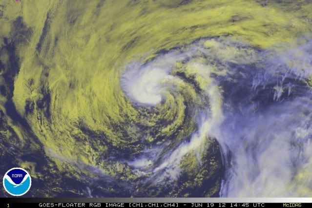
It has convection in the center and spiraling bands on all sides in oppose to yesterday in which it looked a bit sheared. 95l is also moving into an area with less wind shear which will support it into becoming a sub-tropical storm?, although the cooler waters won't let it become fully tropical.
0 likes
Personal Forecast Disclaimer:
The posts in this forum are NOT official forecast and should not be used as such. They are just the opinion of the poster and may or may not be backed by sound meteorological data. They are NOT endorsed by any professional institution or storm2k.org. For official information, please refer to the NHC and NWS products.
The posts in this forum are NOT official forecast and should not be used as such. They are just the opinion of the poster and may or may not be backed by sound meteorological data. They are NOT endorsed by any professional institution or storm2k.org. For official information, please refer to the NHC and NWS products.
-
cycloneye
- Admin
- Posts: 149813
- Age: 69
- Joined: Thu Oct 10, 2002 10:54 am
- Location: San Juan, Puerto Rico
Re: ATL: INVEST 95L
00z Best Track.
AL, 95, 2012061900, , BEST, 0, 385N, 605W, 40, 1005, LO
http://ftp.nhc.noaa.gov/atcf/tcweb/inve ... 012.invest
AL, 95, 2012061900, , BEST, 0, 385N, 605W, 40, 1005, LO
http://ftp.nhc.noaa.gov/atcf/tcweb/inve ... 012.invest
0 likes
Visit the Caribbean-Central America Weather Thread where you can find at first post web cams,radars
and observations from Caribbean basin members Click Here
and observations from Caribbean basin members Click Here
-
cycloneye
- Admin
- Posts: 149813
- Age: 69
- Joined: Thu Oct 10, 2002 10:54 am
- Location: San Juan, Puerto Rico
Re: ATL: INVEST 95L

0 likes
Visit the Caribbean-Central America Weather Thread where you can find at first post web cams,radars
and observations from Caribbean basin members Click Here
and observations from Caribbean basin members Click Here
-
TropicalAnalystwx13
- Category 5
- Posts: 2109
- Age: 28
- Joined: Tue Jul 19, 2011 8:20 pm
- Location: Wilmington, NC
- Contact:
-
Brent
- S2K Supporter
- Posts: 38786
- Age: 37
- Joined: Sun May 16, 2004 10:30 pm
- Location: Tulsa Oklahoma
- Contact:
Re: ATL: INVEST 95L
Down to orange
TROPICAL WEATHER OUTLOOK
NWS NATIONAL HURRICANE CENTER MIAMI FL
200 AM EDT TUE JUN 19 2012
FOR THE NORTH ATLANTIC...CARIBBEAN SEA AND THE GULF OF MEXICO...
1. SHOWERS AND THUNDERSTORMS ASSOCIATED WITH A NON-TROPICAL LOW
LOCATED ABOUT 550 MILES NORTHEAST OF BERMUDA HAVE DECREASED THIS
EVENING. THE CHANCES FOR DEVELOPMENT OF THIS SYSTEM ARE DECREASING
AS THE LOW IS FORECAST TO ENCOUNTER COOLER WATERS AND A MORE STABLE
ATMOSPHERE WITHIN A DAY OR SO. THIS SYSTEM HAS A MEDIUM CHANCE...
50 PERCENT...OF BECOMING A TROPICAL OR SUBTROPICAL CYCLONE DURING
THE NEXT 48 HOURS AS IT MOVES EAST-NORTHEASTWARD AT 10 TO 15 MPH.
FOR ADDITIONAL INFORMATION ON THIS SYSTEM...PLEASE SEE HIGH SEAS
FORECASTS ISSUED BY THE OCEAN PREDICTION CENTER.
ELSEWHERE...TROPICAL CYCLONE FORMATION IS NOT EXPECTED DURING THE
NEXT 48 HOURS.
&&
HIGH SEAS FORECASTS ISSUED BY THE NATIONAL WEATHER SERVICE CAN BE
FOUND UNDER AWIPS HEADER NFDHSFAT1 AND WMO HEADER FZNT01 KWBC.
$$
FORECASTER BLAKE
0 likes
#neversummer
-
cycloneye
- Admin
- Posts: 149813
- Age: 69
- Joined: Thu Oct 10, 2002 10:54 am
- Location: San Juan, Puerto Rico
Re: ATL: INVEST 95L
Stays at 50% at 8 AM EDT TWO:
A NON-TROPICAL LOW PRESSURE SYSTEM LOCATED ABOUT 440 MILES SOUTHEAST
OF HALIFAX NOVA SCOT IA IS PRODUCING A LIMITED AREA OF SHOWERS AND
THUNDERSTORMS. THERE IS STILL A POTENTIAL FOR THIS SYSTEM TO
DEVELOP INTO A TROPICAL CYCLONE BEFORE IT ENCOUNTERS COOLER WATERS
AND A MORE STABLE ATMOSPHERE IN A DAY OR SO. THIS SYSTEM HAS A
MEDIUM CHANCE...50 PERCENT...OF BECOMING A TROPICAL CYCLONE DURING
THE NEXT 48 HOURS AS IT MOVES EAST-NORTHEASTWARD AT 10 TO 15 MPH.
FOR ADDITIONAL INFORMATION ON THIS SYSTEM...PLEASE SEE HIGH SEAS
FORECASTS ISSUED BY THE OCEAN PREDICTION CENTER.
0 likes
Visit the Caribbean-Central America Weather Thread where you can find at first post web cams,radars
and observations from Caribbean basin members Click Here
and observations from Caribbean basin members Click Here
-
Florida1118
Re: ATL: INVEST 95L

Looks like it is starting to rebound from yesterday...We will see how it progresses.
0 likes
-
Hurricanehink

- S2K Supporter
- Posts: 2046
- Joined: Sun Nov 16, 2003 2:05 pm
- Location: New Jersey
Re: ATL: INVEST 95L
Convection has certainly been increasing, but it's already at almost 40ºN.
0 likes
-
Florida1118
Re: ATL: INVEST 95L
Hurricanehink wrote:Convection has certainly been increasing, but it's already at almost 40ºN.
The models take it parallel to 40N, so it shouldnt be going too far north of that. Its got a shot, it just needs to keep convection today.

From Dr.Masters:
A well-organized low pressure system with a closed surface circulation but little heavy thunderstorm activity (Invest 95L) is over the open Atlantic between Bermuda and Canada. This storm doesn't have enough heavy thunderstorms to deserve a name, but has a 50% chance of doing so before hitting colder waters on Wednesday, according to NHC. 95L is headed northeast out to sea, and will not trouble any land areas.
0 likes


-
ozonepete
- Professional-Met

- Posts: 4743
- Joined: Mon Sep 07, 2009 3:23 pm
- Location: From Ozone Park, NYC / Now in Brooklyn, NY
Re: ATL: INVEST 95L
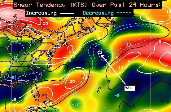
Convection wrapping around the center again. Shear is very low there now and dropping to the north and east along its path as well. Also with 25C SSTs to the north and east, where it's headed, I would say this still has a pretty decent shot at TS. But it's only got about 24 more hours...
0 likes
Who is online
Users browsing this forum: No registered users and 39 guests