ATL: DEBBY - Post-Tropical
Moderator: S2k Moderators
-
Weatherfreak000
-
Jevo

- S2K Supporter

- Posts: 1729
- Age: 47
- Joined: Tue Aug 03, 2004 8:45 pm
- Location: The Flemish Cap
- Contact:
Re:
KWT wrote:Weakness is still strong enough for the system to scoot off to the east towards Florida. It maybe a touch slower this run but it gets to Florida by 72hrs. To be fair that is a *classic* June type track for a sheared system.
Yeah +72 definitely has it being yanked up into the weakness

0 likes
Disclaimer: 50% of the time I have no clue of what I am talking about. Chances are I am taking a less than educated guess that sounds good because 10 years ago I stole Mike Watkins book 'The Hurricane and its Impact'. For official information please direct yourself to the NHC and their cadre of weather geniuses.
-
jlauderdal
- S2K Supporter
- Posts: 7240
- Joined: Wed May 19, 2004 5:46 am
- Location: NE Fort Lauderdale
- Contact:
Re: ATL: DEBBY-Tropical Storm
0415 PM TORNADO NAPLES 26.14N 81.80W
06/23/2012 COLLIER FL EMERGENCY MNGR
*** 1 INJ *** A POSSIBLE TORNADO PASSED OVER NORTH
COLLIER HOSPITAL IN NAPLES. DAMAGES CONSISTED OF DOWNED
TREE LIMBS AND BROKEN STREET LIGHTS ON A PARKING GARAGE.
ONE PERSON WAS STRUCK BY ONE OF THE DOWNED TREE LIMBS AND
WAS TREATED.
06/23/2012 COLLIER FL EMERGENCY MNGR
*** 1 INJ *** A POSSIBLE TORNADO PASSED OVER NORTH
COLLIER HOSPITAL IN NAPLES. DAMAGES CONSISTED OF DOWNED
TREE LIMBS AND BROKEN STREET LIGHTS ON A PARKING GARAGE.
ONE PERSON WAS STRUCK BY ONE OF THE DOWNED TREE LIMBS AND
WAS TREATED.
0 likes
-
Dave

- Retired Staff

- Posts: 13442
- Age: 75
- Joined: Tue Aug 01, 2006 3:57 pm
- Location: Milan Indiana
- Contact:

0 likes
This post is NOT AN OFFICIAL FORECAST and should not be used as such. It is just the opinion of the poster and may or may not be backed by sound meteorological data. It is NOT endorsed by any professional institution including storm2k.org. For Official Information please refer to the NHC and NWS products.

Re: ATL: DEBBY - Models
I'm starting to think if Debby stays sheared and moderate TS then she heads off to the NE like GFS. You have to give kudos to GFS for sticking with this solution now for what 10 runs in row? This storm will definitely be an EPIC fail for one of two big models.
0 likes
-
Jevo
- S2K Supporter
- Posts: 1729
- Age: 47
- Joined: Tue Aug 03, 2004 8:45 pm
- Location: The Flemish Cap
- Contact:
18z GFS +72 Landfall (squeezed between a ridge and a hard place)

0 likes
Disclaimer: 50% of the time I have no clue of what I am talking about. Chances are I am taking a less than educated guess that sounds good because 10 years ago I stole Mike Watkins book 'The Hurricane and its Impact'. For official information please direct yourself to the NHC and their cadre of weather geniuses.
-
CYCLONE MIKE
- Category 5

- Posts: 2183
- Joined: Tue Aug 31, 2004 6:04 pm
- Location: Gonzales, LA
Re: ATL: DEBBY - Models
ROCK wrote:IMO, it was the right call for the NHC. The EURO is by far the best performing model we have except maybe the FSU super duper model that no-one can see....
What is that model showing btw. I know in years past we had a few members that would post it or at least tell us what it was showing?
0 likes
-
Evil Jeremy

- S2K Supporter
- Posts: 5463
- Age: 32
- Joined: Mon Apr 10, 2006 2:10 pm
- Location: Los Angeles, CA
Re:
Aric Dunn wrote:so far the gfs is nailing it.
Don't tell that to the NHC...
0 likes
Frances 04 / Jeanne 04 / Katrina 05 / Wilma 05 / Fay 08 / Debby 12 / Andrea 13 / Colin 16 / Hermine 16 / Matthew 16 / Irma 17

Looks like system is getting really sheared to pieces on thye GFS 18z run by 72hrs as well, that run reminds me somewhat of Alberto.
Certainly one of the models is given to be very wrong!
Certainly one of the models is given to be very wrong!
0 likes
Personal Forecast Disclaimer:
The posts in this forum are NOT official forecast and should not be used as such. They are just the opinion of the poster and may or may not be backed by sound meteorological data. They are NOT endorsed by any professional institution or storm2k.org. For official information, please refer to the NHC and NWS products
The posts in this forum are NOT official forecast and should not be used as such. They are just the opinion of the poster and may or may not be backed by sound meteorological data. They are NOT endorsed by any professional institution or storm2k.org. For official information, please refer to the NHC and NWS products
-
ozonepete
- Professional-Met

- Posts: 4743
- Joined: Mon Sep 07, 2009 3:23 pm
- Location: From Ozone Park, NYC / Now in Brooklyn, NY
Re: Re:
Tireman4 wrote:ozonepete wrote:Tireman4 wrote:Correct me if I am wrong, but did not the models for Ike have him hitting the lower Texas coast and then they slowly progressed to the upper Texas coast? I think that is what Ikester is referring to as to being right of track when first time it comes out..I think...
But you can't compare them unless you get out all of the archived surface and especially upper air charts for many days for Ike and compared them to what's going on, and will go on for Debby. Steering is complex and unique to each storm.
I understand that. I was stating that was an example of a storm going right of first track. That is all. Very general statement. I am not as smart as many on this board. I am just making a comment.
I know. It's just hard to watch all of the comparisons being made on here of very different storms with no discussion of what caused the steering. Very frustrating to see. And I'm sure you are very smart - looks that way to me anyway.
0 likes
-
stormhunter7

- Category 2

- Posts: 763
- Joined: Mon May 26, 2008 3:13 pm
- Location: Panama City Beach, Florida
- Contact:
Re: ATL: DEBBY-Tropical Storm
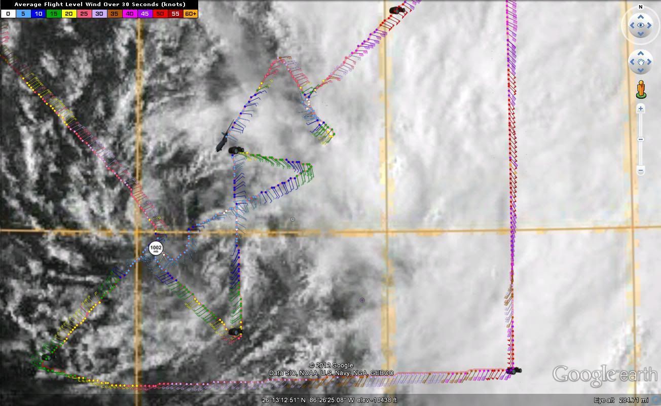
Looks like recon found a second center to the NE of current Debby (105 miles to NE of Debby)
Last edited by stormhunter7 on Sat Jun 23, 2012 4:59 pm, edited 1 time in total.
0 likes
The following post is NOT an official forecast and should not be used as such. It is just the opinion of the poster and may or may not be backed by sound meteorological data. It is NOT endorsed by any professional institution including storm2k.org For Official Information please refer to the NHC and NWS products. http://www.nhc.noaa.gov
-
hurricanefloyd5

- Category 5
- Posts: 1659
- Age: 45
- Joined: Sun May 02, 2004 10:53 am
- Location: Spartanburg
- Contact:
Re: Re:
Evil Jeremy wrote:Aric Dunn wrote:so far the gfs is nailing it.
Don't tell that to the NHC...
acir you mean it's headed for florida
0 likes

Re: ATL: DEBBY-Tropical Storm
stormhunter7 wrote:Looks like recon found a second center to the NE of current Debby
More like a 4th center.
0 likes
-
Hurricaneman

- Category 5
- Posts: 7404
- Age: 45
- Joined: Tue Aug 31, 2004 3:24 pm
- Location: central florida
Re: ATL: DEBBY-Tropical Storm
jlauderdal wrote:0415 PM TORNADO NAPLES 26.14N 81.80W
06/23/2012 COLLIER FL EMERGENCY MNGR
*** 1 INJ *** A POSSIBLE TORNADO PASSED OVER NORTH
COLLIER HOSPITAL IN NAPLES. DAMAGES CONSISTED OF DOWNED
TREE LIMBS AND BROKEN STREET LIGHTS ON A PARKING GARAGE.
ONE PERSON WAS STRUCK BY ONE OF THE DOWNED TREE LIMBS AND
WAS TREATED.
I think if this moves a little closer to Florida, I wouldn't be suprised if there is a tornado watch for the western counties of Florida
The posts in this forum are NOT official forecast and should not be used as such. They are just the opinion of the poster and may or may not be backed by sound meteorological data. They are NOT endorsed by any professional institution or storm2k.org. For official information, please refer to the NHC and NWS products
0 likes
-
Dave
- Retired Staff
- Posts: 13442
- Age: 75
- Joined: Tue Aug 01, 2006 3:57 pm
- Location: Milan Indiana
- Contact:
000
URNT15 KNHC 232156
AF302 01AAA INVEST HDOB 38 20120623
214900 2709N 08657W 8430 01512 //// +190 //// 065028 028 023 003 01
214930 2708N 08658W 8430 01511 //// +191 //// 065026 027 023 003 01
215000 2708N 08658W 8430 01511 //// +194 //// 066026 027 022 001 01
215030 2705N 08700W 8429 01515 //// +191 //// 070024 026 022 003 01
215100 2703N 08701W 8429 01515 //// +191 //// 071022 023 021 003 01
215130 2702N 08702W 8430 01513 //// +188 //// 067017 020 021 003 01
215200 2700N 08703W 8428 01515 //// +180 //// 066012 013 016 003 01
215230 2659N 08705W 8430 01513 //// +172 //// 058010 012 006 003 01
215300 2657N 08706W 8428 01514 //// +155 //// 066010 011 006 005 01
215330 2656N 08707W 8429 01516 //// +163 //// 084009 012 008 004 01
215400 2655N 08708W 8428 01514 //// +167 //// 076011 012 003 003 01
215430 2653N 08709W 8430 01514 //// +164 //// 087008 010 002 004 01
215500 2652N 08710W 8429 01514 //// +164 //// 094010 011 005 004 01
215530 2650N 08711W 8431 01509 //// +165 //// 103009 010 002 004 01
215600 2649N 08712W 8429 01512 //// +162 //// 124009 010 005 004 01
215630 2648N 08713W 8429 01509 //// +165 //// 122010 011 011 004 01
215700 2646N 08714W 8425 01517 //// +163 //// 108010 012 016 003 01
215730 2645N 08715W 8431 01509 //// +166 //// 105008 010 014 002 01
215800 2643N 08716W 8432 01508 //// +167 //// 122007 007 015 003 01
215830 2642N 08717W 8430 01508 //// +169 //// 118006 007 015 003 01
$$
;
0 likes
This post is NOT AN OFFICIAL FORECAST and should not be used as such. It is just the opinion of the poster and may or may not be backed by sound meteorological data. It is NOT endorsed by any professional institution including storm2k.org. For Official Information please refer to the NHC and NWS products.
Re: ATL: DEBBY-Tropical Storm
stormhunter7 wrote:Looks like recon found a second center to the NE of current Debby
As probably would be expected with the convection being in that area, its actually a very unorganised system despite actually packing fairly decent winds, the structure isn't all that great with multiple vortexes swirling around from the looks of things.
Too early to tell where this system is going, sorta depends on how fast this moves, how quick the trough withdraws and how many times this system tries to re-locate to the N/NE (which IMO is highly likely.)
0 likes
Personal Forecast Disclaimer:
The posts in this forum are NOT official forecast and should not be used as such. They are just the opinion of the poster and may or may not be backed by sound meteorological data. They are NOT endorsed by any professional institution or storm2k.org. For official information, please refer to the NHC and NWS products
The posts in this forum are NOT official forecast and should not be used as such. They are just the opinion of the poster and may or may not be backed by sound meteorological data. They are NOT endorsed by any professional institution or storm2k.org. For official information, please refer to the NHC and NWS products
Re: Re:
Evil Jeremy wrote:Aric Dunn wrote:so far the gfs is nailing it.
Don't tell that to the NHC...
I will say that the big globals struggle with non-vertically stacked, sheared systems. If the GFS nails this one, we'll all have to give a big pat on the back to the programmers who updated the code in May. On the other hand....those programmers may be fired if the Euro verifies, LOL.
0 likes
-
TeamPlayersBlue

- Category 5
- Posts: 3529
- Joined: Tue Feb 02, 2010 1:44 am
- Location: Denver/Applewood, CO
Sit out in the gulf till thursday and its supposed to stay a TS? Anybody else find that quite humorous?
The following post is NOT an official forecast and should not be used as such. It is just the opinion of the poster and may or may not be backed by sound meteorological data. It is NOT endorsed by any professional institution including storm2k.org For Official Information please refer to the NHC and NWS products.
The following post is NOT an official forecast and should not be used as such. It is just the opinion of the poster and may or may not be backed by sound meteorological data. It is NOT endorsed by any professional institution including storm2k.org For Official Information please refer to the NHC and NWS products.
0 likes
Personal Forecast Disclaimer:
The posts in this forum are NOT official forecast and should not be used as such. They are just the opinion of the poster and may or may not be backed by sound meteorological data. They are NOT endorsed by any professional institution or storm2k.org. For official information, please refer to the NHC and NWS products.
The posts in this forum are NOT official forecast and should not be used as such. They are just the opinion of the poster and may or may not be backed by sound meteorological data. They are NOT endorsed by any professional institution or storm2k.org. For official information, please refer to the NHC and NWS products.
-
ozonepete
- Professional-Met
- Posts: 4743
- Joined: Mon Sep 07, 2009 3:23 pm
- Location: From Ozone Park, NYC / Now in Brooklyn, NY
Re: ATL: DEBBY-Tropical Storm
RL3AO wrote:stormhunter7 wrote:Looks like recon found a second center to the NE of current Debby
More like a 4th center.
LOL, yeah. But in all honesty, there sure seems to be some major vorticity forming well to the east-northeast of the currently marked center. And there seems to be convection circling it as well. This storm is young and disorganized enough that the center could reform there. Very interesting to watch right now.
0 likes
Who is online
Users browsing this forum: No registered users and 218 guests