ATL: ISAAC - Models
Moderator: S2k Moderators
- Meteorcane
- Category 2

- Posts: 559
- Joined: Thu Jul 21, 2011 6:49 am
- Location: North Platte Nebraska
Re: ATL: ISAAC - Models
yeah don't really look at the GFS' pressure it tends to be too high, on the other hand the GFDL and HWRF tend to be create too deep systems, I would say the GFS has a Cat.2ish system when it makes its SFLA landfall in this run. Although the pressure would be indicative of a strong T.S./weak Cat.1. I am surprised that it does not get torn up that much by Haiti, but it does seem to miss most of the spine of Cuba would could explain the intensity.
0 likes
Re: ATL: ISAAC - Models
SouthFLTropics wrote:ROCK wrote:blp wrote:So much for following the euro's trend. This looks more to the right.
yep way different runs....GFS is slowly moving over to the NOGAPS, CMC camp now....
So Rock are you saying that NOGAPS and CMC may have had this right all along??? What a coup that would be for those models. I'm going on my gut but I don't think you will see GFS go much further East. Maybe back west a hair. I'm thinking right up the spine of the state. GFS and the consensus are locking in on a solution.
SFT
yeah the CMC and NOGAPS have been the right outliers for days now.....that would be a coup for those models....especially the NOGAPS....
0 likes
-
Wx_Warrior
- Category 5

- Posts: 2718
- Joined: Thu Aug 03, 2006 3:58 pm
- Location: Beaumont, TX
Re: ATL: ISAAC - Models
And some were thinking this would go further west?
@Rock - How many runs is the for GFS to show a east FLA track?
@Rock - How many runs is the for GFS to show a east FLA track?
0 likes
interesting right shift here. there's plenty of time for the storm to miss florida to the east should such a trend establish itself. i'm not suggesting that is what will ultimately transpire but that is what happened last year with Irene. for the longest time irene's recurve zone was 80 to 85 longitude suggesting a peninsula strike or extreme eastern gulf and it wavered back and forth but stayed within that zone...until it didn't and it swung east and stayed there. fun times ahead.
0 likes
Re: ATL: ISAAC - Models
Wx_Warrior wrote:And some were thinking this would go further west?
@Rock - How many runs is the for GFS to show a east FLA track?
many.....the GFS 2 days ago said Texas then swung all the way to FL the next run and has stayed on either side of it for a few days now....I have seen a few EC FL runs...
0 likes
Re: ATL: ISAAC - Models
as much as I want to stay up from the EURO....not sure I can hang tonight...
0 likes
- SouthFLTropics
- Category 5

- Posts: 4258
- Age: 50
- Joined: Thu Aug 14, 2003 8:04 am
- Location: Port St. Lucie, Florida
Re: ATL: ISAAC - Models
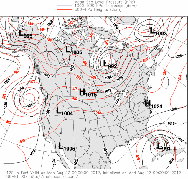
speaking of NOGAPS......0Z NOGAPS....out 120hr
https://www.fnmoc.navy.mil/wxmap_cgi/cg ... t=Tropical
https://www.fnmoc.navy.mil/wxmap_cgi/cg ... t=Tropical
0 likes
Re: ATL: ISAAC - Models
So out of the Big Bend area run and back to home inTallehasse all in all a small shift E.I can tell ya that once I take my sleep meds those guy s on the right need to calm down it's a war in the smiley convention fright sheees though little suckers are mean
0 likes
- southerngale
- Retired Staff

- Posts: 27418
- Joined: Thu Oct 10, 2002 1:27 am
- Location: Southeast Texas (Beaumont area)
Re: ATL: ISAAC - Models
ROCK wrote:as much as I want to stay up from the EURO....not sure I can hang tonight...
Yeah. See you in a few hours, ROCK.
Sent from my DROID BIONIC using Tapatalk 2
0 likes
- Bocadude85
- Category 5

- Posts: 2991
- Age: 39
- Joined: Mon Apr 18, 2005 2:20 pm
- Location: Honolulu,Hi
Re:
psyclone wrote:interesting right shift here. there's plenty of time for the storm to miss florida to the east should such a trend establish itself. i'm not suggesting that is what will ultimately transpire but that is what happened last year with Irene. for the longest time irene's recurve zone was 80 to 85 longitude suggesting a peninsula strike or extreme eastern gulf and it wavered back and forth but stayed within that zone...until it didn't and it swung east and stayed there. fun times ahead.
The diffrence with Irene though is that she went north of Hispanola
http://en.wikipedia.org/wiki/File:Irene_2011_track.png
0 likes
Re: ATL: ISAAC - Models
southerngale wrote:ROCK wrote:as much as I want to stay up from the EURO....not sure I can hang tonight...
Yeah. See you in a few hours, ROCK.
Sent from my DROID BIONIC using Tapatalk 2
you know me too well!!
0 likes
- Jevo
- S2K Supporter

- Posts: 1729
- Age: 47
- Joined: Tue Aug 03, 2004 8:45 pm
- Location: The Flemish Cap
- Contact:
It's a shame the G-IV isnt going out until Thursday. I would love to have the data in tomorrow night's models
2. SUCCEEDING DAY OUTLOOK:
A. CONTINUE 6-HRLY FIXES.
B. A NOAA P-3 MISSION AT 23/2000Z AND 24/0800Z.
C. A G-IV SYNOPTIC FLOW MISSION AT 23/1730Z.
2. SUCCEEDING DAY OUTLOOK:
A. CONTINUE 6-HRLY FIXES.
B. A NOAA P-3 MISSION AT 23/2000Z AND 24/0800Z.
C. A G-IV SYNOPTIC FLOW MISSION AT 23/1730Z.
0 likes
Disclaimer: 50% of the time I have no clue of what I am talking about. Chances are I am taking a less than educated guess that sounds good because 10 years ago I stole Mike Watkins book 'The Hurricane and its Impact'. For official information please direct yourself to the NHC and their cadre of weather geniuses.
- Rgv20
- S2K Supporter

- Posts: 2466
- Age: 39
- Joined: Wed Jan 05, 2011 5:42 pm
- Location: Edinburg/McAllen Tx
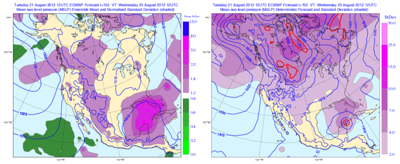
Looking at the 12zECMWF Ensemble Spreads it looks like the Operational is to the left of its Ensemble Members....It is going to be an interesting 0z run tonight.
Forecast Valid for Wednesday Morning August 29.

Forecast Valid for Wednesday Morning August 29.

0 likes
The following post is NOT an official forecast and should not be used as such. It is just the opinion of the poster and may or may not be backed by sound meteorological data. It is NOT endorsed by any professional institution including storm2k.org For Official Information please refer to the NHC and NWS products.
- Meteorcane
- Category 2

- Posts: 559
- Joined: Thu Jul 21, 2011 6:49 am
- Location: North Platte Nebraska
- Riptide
- Category 2

- Posts: 753
- Age: 34
- Joined: Fri Jul 23, 2010 3:33 pm
- Location: Cape May, New Jersey
- Contact:
Re: ATL: ISAAC - Models
The 0z CMC is still east of all other major global models, with a rather potent Isaac passing through the Bahamas.
0 likes
- Rgv20
- S2K Supporter

- Posts: 2466
- Age: 39
- Joined: Wed Jan 05, 2011 5:42 pm
- Location: Edinburg/McAllen Tx
0zUKMET to South Florida in 5 days...Just a bit faster than tonight's Official Forecast.


0 likes
The following post is NOT an official forecast and should not be used as such. It is just the opinion of the poster and may or may not be backed by sound meteorological data. It is NOT endorsed by any professional institution including storm2k.org For Official Information please refer to the NHC and NWS products.
- Jevo
- S2K Supporter

- Posts: 1729
- Age: 47
- Joined: Tue Aug 03, 2004 8:45 pm
- Location: The Flemish Cap
- Contact:
I believe the 0z HWRF is rolling out right now... Someone correct me if im wrong, but I believe this is it initialized

+24

+48


+24

+48

0 likes
Disclaimer: 50% of the time I have no clue of what I am talking about. Chances are I am taking a less than educated guess that sounds good because 10 years ago I stole Mike Watkins book 'The Hurricane and its Impact'. For official information please direct yourself to the NHC and their cadre of weather geniuses.
- meriland23
- Category 5

- Posts: 1239
- Age: 38
- Joined: Mon Aug 29, 2011 9:29 pm
when is the oz euro run? CT time
0 likes
The posts in this forum are NOT official forecast and should not be used as such. They are just the opinion of the poster and may or may not be backed by sound meteorological data. They are NOT endorsed by any professional institution or storm2k.org. For official information, please refer to the NHC and NWS products.
Who is online
Users browsing this forum: No registered users and 403 guests


 my Cowboys
