ATL: DEBBY - Post-Tropical

Moderator: S2k Moderators

Message
Author
CYCLONE MIKE
Category 5
Category 5
Posts: 2183
Joined: Tue Aug 31, 2004 6:04 pm
Location: Gonzales, LA

Re: ATL: INVEST 96L - Models

#1201 Postby CYCLONE MIKE » Sat Jun 23, 2012 8:42 am

Ivanhater wrote:
CYCLONE MIKE wrote:So its now showing this go north, west a bit, north again right at Buras, then 90 degree right turn towards FL. Interesting


Well the NHC track but be a bit smoother than that, I'm not sure what they would do honestly. They really like the TVCN and usually follow pretty closely with that but with the Euro going against that, I am curious what kind of track they would do. Luckily, they have the 12z suite before they put out a track


Seems your map updated some. Now shows making landfall in LA going across New Orleans to biloxi then due east to your backyard along the entire coastline. Strange
0 likes   

jinftl
Category 5
Category 5
Posts: 4312
Joined: Tue Aug 31, 2004 4:47 pm
Location: fort lauderdale, fl

Re: ATL: INVEST 96L - Discussion

#1202 Postby jinftl » Sat Jun 23, 2012 8:44 am

Dr. Jeff Masters discussion this morning:
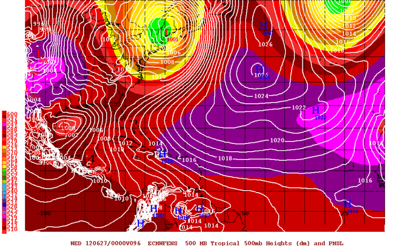

Forecast for 96L
Wind shear is predicted to remain in the moderate range through Sunday night, which is likely low enough to allow 96L to develop into a tropical depression or tropical storm by Sunday; NHC gave 96L a 90% chance of developing into a tropical depression by Monday morning, in their 8am EDT Tropical Weather Outlook. The future path of 96L is still unclear. The disturbance will drift slowly northwards through Sunday night, which will likely bring heavy rains of 2 - 4 inches to the Gulf Coast from Central Louisiana to Central Florida. A storm surge of 1 - 3 feet is also likely along the Southeast Louisiana coast on Sunday; coastal flood advisories have already been posted there. By Monday, the majority of the reliable models, including the ECMWF, NOGAPS, HWRF, and UKMET, agree that a ridge of high pressure will build in over the Southern U.S., forcing 96L westwards across the Gulf of Mexico and into South Texas by Wednesday. However, the GFS model, which has been our 2nd most reliable track model over the past two years (behind the ECMWF), has consistently been predicting that a trough of low pressure pushing off of the U.S. East Coast will be capable of grabbing the disturbance and accelerating it to the northeast across Florida north of Tampa Bay on Monday. The GFDL model splits the difference between these extremes, taking 96L northwards to a landfall near the Alabama/Florida border on Tuesday. Given that the majority of the models predict a westward track to Texas, that should be viewed as the most probable path for 96L, but this is a low-confidence forecast.

None of the models is predicting 96L will become a hurricane, and the SHIPS model is predicting just a 4% chance of rapid intensification for 96L. Given the moderate levels of wind shear and dry air over the Gulf, only slow to modest intensification of 96L is likely over the next few days.
0 likes   

bella_may
Category 4
Category 4
Posts: 908
Joined: Wed Dec 22, 2010 2:13 pm
Location: SE Mississippi coast

Re:

#1203 Postby bella_may » Sat Jun 23, 2012 8:44 am

Rgv20 wrote:The 0z Operational ECMWF has the majority of the Ensembles supporting the idea of a South Texas landfall.

0zECMWF Ensemble Means forecast valid for Tuesday Evening.
Image

0zCMC Ensembles still agree on a more westward track to Texas rather than LA like the operational run showed.
Image

Those models are initiated way too far west. The further north this thing goes its more likely this will be a Florida storm IMO.
0 likes   

User avatar
Tampa Bay Hurricane
Category 5
Category 5
Posts: 5597
Age: 37
Joined: Fri Jul 22, 2005 7:54 pm
Location: St. Petersburg, FL

#1204 Postby Tampa Bay Hurricane » Sat Jun 23, 2012 8:47 am

The large swath of light green color offshore the west coast of Florida appears to indicate
winds of tropical storm force in gusts...this thing is getting its act together despite shear...

http://radar.weather.gov/radar.php?rid= ... 1&loop=yes
0 likes   

Air Force Met
Military Met
Military Met
Posts: 4372
Age: 56
Joined: Tue Jul 08, 2003 9:30 am
Location: Roan Mountain, TN

Re:

#1205 Postby Air Force Met » Sat Jun 23, 2012 8:47 am

Hurricane Andrew wrote:CIMSS Shear Tendency
http://tropic.ssec.wisc.edu/real-time/w ... oom=&time=


And one thing people need to understand about that map and what it is saying: Yes it shows the shear decreasing over the storm but that does not mean the winds are getting more conducive for development. The reason the shear has dropped in that area is because the upper trof/ULL has moved OVER that area...so the winds on teh east side of the trof, which were 20-30 kts have dropped to 10 kts near the trof/ULL.

So just because shear tendency maps show a decrease in shear does not mean its getting better out there. It might mean (and does in this case) that an upper low is getting closer and the upper winds are dropping off as a response to the decrease in gradient/contour force.
0 likes   

User avatar
cycloneye
Admin
Admin
Posts: 145414
Age: 68
Joined: Thu Oct 10, 2002 10:54 am
Location: San Juan, Puerto Rico

Re: ATL: INVEST 96L - Discussion

#1206 Postby cycloneye » Sat Jun 23, 2012 8:55 am

AFM,do you think being already around 26N means is too late to turn west or is still possible to track that way?
0 likes   
Visit the Caribbean-Central America Weather Thread where you can find at first post web cams,radars
and observations from Caribbean basin members Click Here

crimi481
Category 2
Category 2
Posts: 602
Joined: Thu Sep 09, 2004 4:47 pm

Re: ATL: INVEST 96L - Discussion

#1207 Postby crimi481 » Sat Jun 23, 2012 8:58 am

For past 2 years - any Trop system that entered Gulf had a ULL as dance partner.
This pattern usually leads to elongated E. Gulf system with moisture training into Fl
Good chance the storm stays in east Gulf for several days. (Disclaimer - I know nothing)
http://www.ssec.wisc.edu/data/geo/index ... thod=flash

There is really no where to go?
0 likes   

User avatar
'CaneFreak
Category 5
Category 5
Posts: 1486
Joined: Mon Jun 05, 2006 10:50 am
Location: New Bern, NC

Re: Re:

#1208 Postby 'CaneFreak » Sat Jun 23, 2012 8:58 am

Good point AFM. I am thinking that it is going to be tough to get much intensification out of this thing due to the proximity of this disturbance to this cold core upper low which does a few things: 1) continues the shear over the disturbance; 2) keeps dry air on the west side of this disturbance which limits thunderstorm development on western side of circulation; 3) tends to keep this thing from strengthening via warm core processes which will, in my opinion, limit strengthening. In my personal opinion, this does not make a run at a CAT 1 hurricane due to these three factors.

Air Force Met wrote:
Hurricane Andrew wrote:CIMSS Shear Tendency
http://tropic.ssec.wisc.edu/real-time/w ... oom=&time=


And one thing people need to understand about that map and what it is saying: Yes it shows the shear decreasing over the storm but that does not mean the winds are getting more conducive for development. The reason the shear has dropped in that area is because the upper trof/ULL has moved OVER that area...so the winds on teh east side of the trof, which were 20-30 kts have dropped to 10 kts near the trof/ULL.

So just because shear tendency maps show a decrease in shear does not mean its getting better out there. It might mean (and does in this case) that an upper low is getting closer and the upper winds are dropping off as a response to the decrease in gradient/contour force.
0 likes   

User avatar
Tampa Bay Hurricane
Category 5
Category 5
Posts: 5597
Age: 37
Joined: Fri Jul 22, 2005 7:54 pm
Location: St. Petersburg, FL

#1209 Postby Tampa Bay Hurricane » Sat Jun 23, 2012 9:00 am

Today Florida should see very heavy rains. The best thing 96L could do is then gradually head towards Texas and Mexico where rain is needed badly. Considering that all the major models except GFS send this west of FL that the ECMWF is one of the best, I am going with a TX/MX storm forecast, with a hurricane possible but not too likely since there is still lots of shear. This scenario, if it occurs, would bring beneficial rains to Texas and Mexico, something they desperately need.

The posts in this forum are NOT official forecast and should not be used as such. They are just the opinion of the poster and may or may not be backed by sound meteorological data. They are NOT endorsed by any professional institution or storm2k.org. For official information, please refer to the NHC and NWS products.
0 likes   

Javlin
Category 5
Category 5
Posts: 1620
Age: 64
Joined: Fri Jul 09, 2004 7:58 pm
Location: ms gulf coast

Re: Re:

#1210 Postby Javlin » Sat Jun 23, 2012 9:03 am

'CaneFreak wrote:Good point AFM. I am thinking that it is going to be tough to get much intensification out of this thing due to the proximity of this disturbance to this cold core upper low which does a few things: 1) continues the shear over the disturbance; 2) keeps dry air on the west side of this disturbance which limits thunderstorm development on western side of circulation; 3) tends to keep this thing from strengthening via warm core processes which will, in my opinion, limit strengthening. In my personal opinion, this does not make a run at a CAT 1 hurricane due to these three factors.

Air Force Met wrote:
Hurricane Andrew wrote:CIMSS Shear Tendency
http://tropic.ssec.wisc.edu/real-time/w ... oom=&time=


And one thing people need to understand about that map and what it is saying: Yes it shows the shear decreasing over the storm but that does not mean the winds are getting more conducive for development. The reason the shear has dropped in that area is because the upper trof/ULL has moved OVER that area...so the winds on teh east side of the trof, which were 20-30 kts have dropped to 10 kts near the trof/ULL.

So just because shear tendency maps show a decrease in shear does not mean its getting better out there. It might mean (and does in this case) that an upper low is getting closer and the upper winds are dropping off as a response to the decrease in gradient/contour force.


Also keeps it from going W ATM and then does not the area fill in with high pressure once the ULL moves out?
0 likes   

Air Force Met
Military Met
Military Met
Posts: 4372
Age: 56
Joined: Tue Jul 08, 2003 9:30 am
Location: Roan Mountain, TN

Re: ATL: INVEST 96L - Discussion

#1211 Postby Air Force Met » Sat Jun 23, 2012 9:05 am

cycloneye wrote:AFM,do you think being already around 26N means is too late to turn west or is still possible to track that way?


It's right where it is supposed to be according to both models 00Z run. It is NE of the EURO's 12z run from yesterday.

Looking at the 12z upper air analysis from this morning, there's not much of a trof there...so I don't think we will see a lot more movement. This jump north could be more of a response to development more than anything else.
0 likes   

User avatar
Recurve
Category 5
Category 5
Posts: 1640
Joined: Tue Aug 16, 2005 8:59 pm
Location: St. Petersburg, FL

Re: ATL: INVEST 96L - Discussion

#1212 Postby Recurve » Sat Jun 23, 2012 9:05 am

Very calm and no rain in St. Pete about 5 miles from the Gulf this morning. Hmmm.
0 likes   

User avatar
robbielyn
Category 5
Category 5
Posts: 1298
Joined: Wed May 07, 2003 9:45 am
Location: brooksville, fl

Re: ATL: INVEST 96L - Discussion

#1213 Postby robbielyn » Sat Jun 23, 2012 9:08 am

Recurve wrote:Very calm and no rain in St. Pete about 5 miles from the Gulf this morning. Hmmm.

Hmmmm what?
0 likes   
Robbielyn McCrary
I know just about enough to sound like I know what I'm talking about sometimes. But for your safety please follow the nhc for truly professional forecasting. :D

User avatar
northjaxpro
S2K Supporter
S2K Supporter
Posts: 8900
Joined: Mon Sep 27, 2010 11:21 am
Location: Jacksonville, FL

#1214 Postby northjaxpro » Sat Jun 23, 2012 9:09 am

Observing WV imagery of the CONUS, the one player which I think will help determine 96L's fate is the potent shortwave which is currently moving through the Upper Plains riding over the ridge over the Intermountian West. I am watching this feature very closely.

This energy may sharpen the trough over the east coast just enough during the Sunday-Monday period and delay the High over the Intermountain West from building farther east. If this happens, then the weakness may be in place to pick 96L up through to the northeast. This is something I am just pointing out.

This is going to be an extremely close call. Fascinating wathcing this unfold.


The posts in this forum are NOT official forecast and should not be used as such. They are just the opinion of the poster and may or may not be backed by sound meteorological data. They are NOT endorsed by any professional institution or storm2k.org. For official information, please refer to the NHC and NWS products.
Last edited by northjaxpro on Sat Jun 23, 2012 9:11 am, edited 1 time in total.
0 likes   
NEVER, EVER SAY NEVER in the tropics and weather in general, and most importantly, with life itself!!

________________________________________________________________________________________

Fay 2008 Beryl 2012 Debby 2012 Colin 2016 Hermine 2016 Julia 2016 Matthew 2016 Irma 2017 Dorian 2019

User avatar
cycloneye
Admin
Admin
Posts: 145414
Age: 68
Joined: Thu Oct 10, 2002 10:54 am
Location: San Juan, Puerto Rico

Re: ATL: INVEST 96L - Discussion

#1215 Postby cycloneye » Sat Jun 23, 2012 9:09 am

Air Force Met wrote:
cycloneye wrote:AFM,do you think being already around 26N means is too late to turn west or is still possible to track that way?


It's right where it is supposed to be according to both models 00Z run. It is NE of the EURO's 12z run from yesterday.

Looking at the 12z upper air analysis from this morning, there's not much of a trof there...so I don't think we will see a lot more movement. This jump north could be more of a response to development more than anything else.


So from now it will start to slowdown and wait for the high to establish to the north right?
0 likes   
Visit the Caribbean-Central America Weather Thread where you can find at first post web cams,radars
and observations from Caribbean basin members Click Here

User avatar
trave2
Tropical Low
Tropical Low
Posts: 36
Joined: Wed Jul 16, 2008 6:15 am
Location: Tampa FL.

Re: ATL: INVEST 96L - Discussion

#1216 Postby trave2 » Sat Jun 23, 2012 9:20 am

center looks to be @ 26.5n 87.5w
Last edited by trave2 on Sat Jun 23, 2012 9:23 am, edited 1 time in total.
0 likes   

Air Force Met
Military Met
Military Met
Posts: 4372
Age: 56
Joined: Tue Jul 08, 2003 9:30 am
Location: Roan Mountain, TN

Re: ATL: INVEST 96L - Discussion

#1217 Postby Air Force Met » Sat Jun 23, 2012 9:20 am

Air Force Met wrote:
cycloneye wrote:AFM,do you think being already around 26N means is too late to turn west or is still possible to track that way?


It's right where it is supposed to be according to both models 00Z run. It is NE of the EURO's 12z run from yesterday.

Looking at the 12z upper air analysis from this morning, there's not much of a trof there...so I don't think we will see a lot more movement. This jump north could be more of a response to development more than anything else.


Amendment: As I sat here looking at the satellite loop and the shear, one thing did occur to me. Even though I think the upper levels are conducive for a movement to the west eventually...we could get into one of those situations where the center reforms and reforms...and gets tugged east and NE by convection. So much so that it really does go NE into FL.

The steering wouldnt take it there...but maybe that is what the GFS is picking up on. Don't know. This may be one of those situations where the low is constantly getting tugged by the convection to the NE and E and before you know it...it works its way into the break in the ridge.

I think this is a possibility.
0 likes   

User avatar
ROCK
Category 5
Category 5
Posts: 9484
Age: 54
Joined: Tue Aug 17, 2004 7:30 am
Location: Kemah, Texas

Re: ATL: INVEST 96L - Models

#1218 Postby ROCK » Sat Jun 23, 2012 9:21 am

is everything cleared up now? :cheesy:
0 likes   

User avatar
Hurricane Andrew
S2K Supporter
S2K Supporter
Posts: 1891
Age: 26
Joined: Sun May 23, 2010 2:53 pm
Location: KS

#1219 Postby Hurricane Andrew » Sat Jun 23, 2012 9:22 am

12z NAM

Hour 24
1002mb storm S of LA, moving WWNW

Hour 36
1002mb, SWish of 24h position

http://raleighwx.americanwx.com/models/ ... TNA036.gif
http://raleighwx.americanwx.com/models/ ... TNA024.gif
0 likes   

The Enthusiast
NREMT-AEMT, WX nerd

Irene '11, Sandy '12, Irma '17 (SAR)

"Hard to think we were born to live this way..." -Wage War

User avatar
cycloneye
Admin
Admin
Posts: 145414
Age: 68
Joined: Thu Oct 10, 2002 10:54 am
Location: San Juan, Puerto Rico

Re: ATL: INVEST 96L - Discussion

#1220 Postby cycloneye » Sat Jun 23, 2012 9:22 am

Air Force Met wrote:
cycloneye wrote:AFM,do you think being already around 26N means is too late to turn west or is still possible to track that way?


It's right where it is supposed to be according to both models 00Z run. It is NE of the EURO's 12z run from yesterday.

Looking at the 12z upper air analysis from this morning, there's not much of a trof there...so I don't think we will see a lot more movement. This jump north could be more of a response to development more than anything else.


Amendment: As I sat here looking at the satellite loop and the shear, one thing did occur to me. Even though I think the upper levels are conducive for a movement to the west eventually...we could get into one of those situations where the center reforms and reforms...and gets tugged east and NE by convection. So much so that it really does go NE into FL.

The steering wouldnt take it there...but maybe that is what the GFS is picking up on. Don't know. This may be one of those situations where the low is constantly getting tugged by the convection to the NE and E and before you know it...it works its way into the break in the ridge.

I think this is a possibility.


Thank you for the answers with the amendement. :) As the proverbial says "We shall see what happens"
0 likes   
Visit the Caribbean-Central America Weather Thread where you can find at first post web cams,radars
and observations from Caribbean basin members Click Here


Return to “2012”

Who is online

Users browsing this forum: No registered users and 6 guests