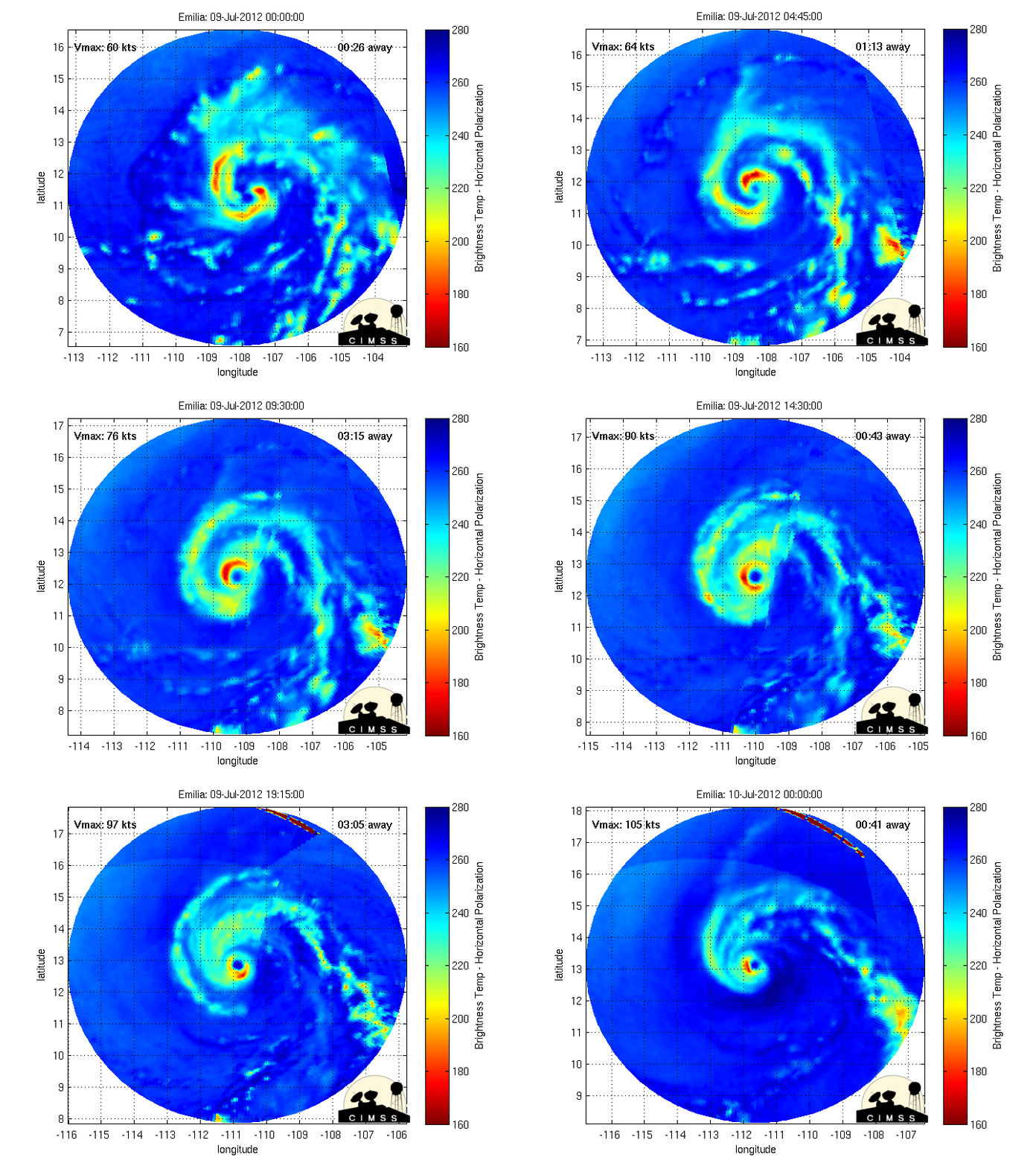
EPAC: EMILIA - Post-Tropical
Moderator: S2k Moderators
- Yellow Evan
- Professional-Met

- Posts: 16257
- Age: 27
- Joined: Fri Jul 15, 2011 12:48 pm
- Location: Henderson, Nevada/Honolulu, HI
- Contact:
- TropicalAnalystwx13
- Category 5

- Posts: 2109
- Age: 28
- Joined: Tue Jul 19, 2011 8:20 pm
- Location: Wilmington, NC
- Contact:
- cycloneye
- Admin

- Posts: 149825
- Age: 69
- Joined: Thu Oct 10, 2002 10:54 am
- Location: San Juan, Puerto Rico
Re:
TropicalAnalystwx13 wrote:Emilia should be a major hurricane by the time of the next advisory.
http://www.ssd.noaa.gov/PS/TROP/floater ... y/rgb0.jpg
Unless an EWRC starts sooner than expected.
0 likes
Visit the Caribbean-Central America Weather Thread where you can find at first post web cams,radars
and observations from Caribbean basin members Click Here
and observations from Caribbean basin members Click Here
- TropicalAnalystwx13
- Category 5

- Posts: 2109
- Age: 28
- Joined: Tue Jul 19, 2011 8:20 pm
- Location: Wilmington, NC
- Contact:
Re:
Yellow Evan wrote:Why are they saying 130 mph peak in the disco and 135 mph peak in the tables?
135 mph is at 5AM PDT and 130 mph is at 8AM PDT.
0 likes
- Yellow Evan
- Professional-Met

- Posts: 16257
- Age: 27
- Joined: Fri Jul 15, 2011 12:48 pm
- Location: Henderson, Nevada/Honolulu, HI
- Contact:
Re: Re:
TropicalAnalystwx13 wrote:Yellow Evan wrote:Why are they saying 130 mph peak in the disco and 135 mph peak in the tables?
135 mph is at 5AM PDT and 130 mph is at 8AM PDT.
NHC does not issue advisories at 5 AM (they give an intensity though).
0 likes
- cycloneye
- Admin

- Posts: 149825
- Age: 69
- Joined: Thu Oct 10, 2002 10:54 am
- Location: San Juan, Puerto Rico
Re: EPAC: EMILIA - Hurricane
Code: Select all
                     UW - CIMSS
              ADVANCED DVORAK TECHNIQUE
                  ADT-Version 8.1.3
         Tropical Cyclone Intensity Algorithm

             ----- Current Analysis -----
     Date :  09 JUL 2012    Time :   150000 UTC
      Lat :   12:39:00 N     Lon :  110:03:13 W


                CI# /Pressure/ Vmax
                5.3 / 964.6mb/ 97.2kt


             Final T#  Adj T#  Raw T#
                5.3     5.4     6.1

 Estimated radius of max. wind based on IR : 16 km

 Center Temp :  -5.1C    Cloud Region Temp : -68.3C

 Scene Type : EYE

 Positioning Method : RING/SPIRAL COMBINATION

 Ocean Basin : EAST PACIFIC
 Dvorak CI > MSLP Conversion Used : PACIFIC

 Tno/CI Rules : Constraint Limits : 1.7T/6hr
                   Weakening Flag : OFF
           Rapid Dissipation Flag : OFF

 C/K/Z MSLP Estimate Inputs :
  - Average 34 knot radii :   62km
  - Environmental MSLP    : 1010mb

 Satellite Viewing Angle : 32.4 degrees

http://tropic.ssec.wisc.edu/real-time/adt/05EP.GIF
0 likes
Visit the Caribbean-Central America Weather Thread where you can find at first post web cams,radars
and observations from Caribbean basin members Click Here
and observations from Caribbean basin members Click Here
- cycloneye
- Admin

- Posts: 149825
- Age: 69
- Joined: Thu Oct 10, 2002 10:54 am
- Location: San Juan, Puerto Rico
Re: EPAC: EMILIA - Hurricane
Note= To keep the images without updating let's upload them with imageshack,tiny pic etc , and by doing it that way,we can conserve them to see the beauty of a powerful hurricane that doesn't threat any landmasses and to preserve them as this thread goes to the archieves forum when all is set and done,thanks to all for the cooperation on this.
0 likes
Visit the Caribbean-Central America Weather Thread where you can find at first post web cams,radars
and observations from Caribbean basin members Click Here
and observations from Caribbean basin members Click Here
- TropicalAnalystwx13
- Category 5

- Posts: 2109
- Age: 28
- Joined: Tue Jul 19, 2011 8:20 pm
- Location: Wilmington, NC
- Contact:
- CobraStrike
- Tropical Wave

- Posts: 6
- Joined: Mon May 28, 2012 2:12 pm
- Location: Texas
Re: EPAC: EMILIA - Hurricane
Hurricane Emilia so far today in MIMIC TC... no signs of EWRC... yet.


0 likes
212 Miles from the Texas Shore
- Yellow Evan
- Professional-Met

- Posts: 16257
- Age: 27
- Joined: Fri Jul 15, 2011 12:48 pm
- Location: Henderson, Nevada/Honolulu, HI
- Contact:
I don't think it will ERC for a while, at least 24-36 hours from now, if ever. Worth noting that if it ERC's while weakening, it will come crashing down like Rick did IMO.
Personal Forecast Disclaimer:
The posts in this forum are NOT official forecast and should not be used as such. They are just the opinion of the poster and may or may not be backed by sound meteorological data. They are NOT endorsed by any professional institution or storm2k.org. For official information, please refer to the NHC and NWS products.
0 likes
- cycloneye
- Admin

- Posts: 149825
- Age: 69
- Joined: Thu Oct 10, 2002 10:54 am
- Location: San Juan, Puerto Rico
Re: EPAC: EMILIA - Hurricane
Closeup view.


0 likes
Visit the Caribbean-Central America Weather Thread where you can find at first post web cams,radars
and observations from Caribbean basin members Click Here
and observations from Caribbean basin members Click Here
- CobraStrike
- Tropical Wave

- Posts: 6
- Joined: Mon May 28, 2012 2:12 pm
- Location: Texas
Re: EPAC: EMILIA - Hurricane
Looks like some dry air got entrained into Emilia as a result of RI:


0 likes
212 Miles from the Texas Shore
- Yellow Evan
- Professional-Met

- Posts: 16257
- Age: 27
- Joined: Fri Jul 15, 2011 12:48 pm
- Location: Henderson, Nevada/Honolulu, HI
- Contact:
Re: EPAC: EMILIA - Hurricane
CobraStrike wrote:Looks like some dry air got entrained into Emilia as a result of RI:
Looks like a phase of unarrested development to me.
0 likes
- Yellow Evan
- Professional-Met

- Posts: 16257
- Age: 27
- Joined: Fri Jul 15, 2011 12:48 pm
- Location: Henderson, Nevada/Honolulu, HI
- Contact:
- Yellow Evan
- Professional-Met

- Posts: 16257
- Age: 27
- Joined: Fri Jul 15, 2011 12:48 pm
- Location: Henderson, Nevada/Honolulu, HI
- Contact:
Re: EPAC: EMILIA - Hurricane
This thing is looking like it's about to go BOOM even more than it already has!!!


0 likes
NOTICE: I cannot give an expert analysis. Most of my "observations" are made visually with the help of only vital information provided by public advisories.
- Yellow Evan
- Professional-Met

- Posts: 16257
- Age: 27
- Joined: Fri Jul 15, 2011 12:48 pm
- Location: Henderson, Nevada/Honolulu, HI
- Contact:
-
euro6208
Re: EPAC: EMILIA - Hurricane
hmm could emilia beat super typhoon guchol for strongest this year? we'll see...
current intensity: 110 knots category 3
emilia could well strengthen some more and i say she will peak at 125 knots before cooler waters takes its toll on this hurricane like all storms in the past.
The posts in this forum are NOT official forecast and should not be used as such. They are just the opinion of the poster and may or may not be backed by sound meteorological data. They are NOT endorsed by any professional institution or storm2k.org. For official information, please refer to the NHC and NWS products.
0 likes
- TropicalAnalystwx13
- Category 5

- Posts: 2109
- Age: 28
- Joined: Tue Jul 19, 2011 8:20 pm
- Location: Wilmington, NC
- Contact:
Code: Select all
 UW - CIMSS
              ADVANCED DVORAK TECHNIQUE
                  ADT-Version 8.1.3
         Tropical Cyclone Intensity Algorithm

             ----- Current Analysis -----
     Date :  09 JUL 2012    Time :   170000 UTC
      Lat :   12:45:16 N     Lon :  110:23:12 W


                CI# /Pressure/ Vmax
                5.3 / 964.5mb/ 97.2kt


             Final T#  Adj T#  Raw T#
                5.2     5.5     5.9

 Estimated radius of max. wind based on IR : 19 km

 Center Temp : +13.2C    Cloud Region Temp : -64.2C

 Scene Type : EYE

 Positioning Method : RING/SPIRAL COMBINATION

 Ocean Basin : EAST PACIFIC
 Dvorak CI > MSLP Conversion Used : PACIFIC

 Tno/CI Rules : Constraint Limits : 1.7T/6hr
                   Weakening Flag : ON
           Rapid Dissipation Flag : OFF

 C/K/Z MSLP Estimate Inputs :
  - Average 34 knot radii :   62km
  - Environmental MSLP    : 1010mb

 Satellite Viewing Angle : 32.1 degrees
0 likes
-
dexterlabio
- Category 5

- Posts: 3520
- Joined: Sat Oct 24, 2009 11:50 pm
Re:
Yellow Evan wrote:
A truly epic hurricane. The EPAC is so awesome.
that thick eye wall would prevent any possible EWRC for the mean time, i think. there is still a lot of time for it to be a lot stronger.
0 likes
Personal Forecast Disclaimer:
The posts in this forum are NOT official forecast and should not be used as such. They are just the opinion of the poster and may or may not be backed by sound meteorological data. They are NOT endorsed by any professional institution or storm2k.org. For official information, please refer to the NHC and NWS products.
The posts in this forum are NOT official forecast and should not be used as such. They are just the opinion of the poster and may or may not be backed by sound meteorological data. They are NOT endorsed by any professional institution or storm2k.org. For official information, please refer to the NHC and NWS products.
Who is online
Users browsing this forum: No registered users and 11 guests


