
90W INVEST 260406 0000 4.5N 159.8E WPAC 15 0
WPAC: SINLAKU - Typhoon
Moderators: S2k Moderators, WesternPacificWeatherMods
Forum rules

The posts in this forum are NOT official forecast and should not be used as such. They are just the opinion of the poster and may or may not be backed by sound meteorological data. They are NOT endorsed by any professional institution or STORM2K.
WPAC: SINLAKU - Typhoon
Last edited by Hayabusa on Fri Apr 10, 2026 5:25 am, edited 2 times in total.
0 likes
ヤンデレ女が寝取られるているのを見たい!!!
ECMWF ensemble NWPAC plots: https://ecmwfensnwpac.imgbb.com/
Multimodel NWPAC plots: https://multimodelnwpac.imgbb.com/
GFS Ensemble NWPAC plots (16 & 35 day forecast): https://gefsnwpac.imgbb.com/
Plots updated automatically
ECMWF ensemble NWPAC plots: https://ecmwfensnwpac.imgbb.com/
Multimodel NWPAC plots: https://multimodelnwpac.imgbb.com/
GFS Ensemble NWPAC plots (16 & 35 day forecast): https://gefsnwpac.imgbb.com/
Plots updated automatically
-
cycloneye

- Admin

- Posts: 149666
- Age: 69
- Joined: Thu Oct 10, 2002 10:54 am
- Location: San Juan, Puerto Rico
Re: WPAC: INVEST 90W
THis will help trigger a big WWB combined with the 2 in SPAC that will iniciate El Niño by the summer.

1 likes
Visit the Caribbean-Central America Weather Thread where you can find at first post web cams,radars
and observations from Caribbean basin members Click Here
and observations from Caribbean basin members Click Here
-
cycloneye
- Admin
- Posts: 149666
- Age: 69
- Joined: Thu Oct 10, 2002 10:54 am
- Location: San Juan, Puerto Rico
Re: WPAC: INVEST 90W
From the GuaM NWS:
Long-range guidance continues to support a broad tropical disturbance developing in
eastern Micronesia that will slowly shift westward into central
Micronesia before potentially lifting northward and closer to the
Marianas late this week or early next week.
This trend has been in the models for a few days suggesting the overall environment is
supportive of a circulation developing within the NET, but so far no
distinct circulation is visible on satellite imagery. Eastern
Micronesia will be monitored closely to see if a circulation begins
to become established over the next few days as the GFS and ECMWF
suggest. If one does, then the potential for showers, thunderstorms,
and some gusty winds around the Marianas will increase late this
week, but for now uncertainty remains elevated for the forecast
beyond Wednesday.
0 likes
Visit the Caribbean-Central America Weather Thread where you can find at first post web cams,radars
and observations from Caribbean basin members Click Here
and observations from Caribbean basin members Click Here
Re: WPAC: INVEST 90W
00z Euro makes this an intense cat 5 over the Philippine Sea but that's if it tracks towards it, other models don't
0 likes
ヤンデレ女が寝取られるているのを見たい!!!
ECMWF ensemble NWPAC plots: https://ecmwfensnwpac.imgbb.com/
Multimodel NWPAC plots: https://multimodelnwpac.imgbb.com/
GFS Ensemble NWPAC plots (16 & 35 day forecast): https://gefsnwpac.imgbb.com/
Plots updated automatically
ECMWF ensemble NWPAC plots: https://ecmwfensnwpac.imgbb.com/
Multimodel NWPAC plots: https://multimodelnwpac.imgbb.com/
GFS Ensemble NWPAC plots (16 & 35 day forecast): https://gefsnwpac.imgbb.com/
Plots updated automatically
-
cycloneye
- Admin
- Posts: 149666
- Age: 69
- Joined: Thu Oct 10, 2002 10:54 am
- Location: San Juan, Puerto Rico
Re: WPAC: INVEST 90W
The trade-wind
surge is weakening near the Marianas but remains a notable feature
north of Pohnpei and Kosrae created by the pressure gradient between
an area of high pressure shifting eastward across the northern
Pacific and the Near-Equatorial Trough (NET) with the embedded
circulation near Pohnpei (Invest 90W). Winds are expected to be
around 15 to 20 mph across the Marianas through Thursday. A broad
circulation, being monitored as Invest 90W, is currently near Pohnpei
and models support a gradual development as it moves northwest. There
is still a large amount of uncertainty if Invest 90W will head
directly towards the Marianas or if there will be a more northeast or
southern track overall. For now, we are watching the potential for
showers, thunderstorms, and gusty winds around the Marianas, with
current timing being sometime between Friday and early next week,
based on current guidance. This forecast will be close monitored and
updated as it becomes more clear how Invest 90W will develop in
eastern Micronesia.
0 likes
Visit the Caribbean-Central America Weather Thread where you can find at first post web cams,radars
and observations from Caribbean basin members Click Here
and observations from Caribbean basin members Click Here
-
cycloneye
- Admin
- Posts: 149666
- Age: 69
- Joined: Thu Oct 10, 2002 10:54 am
- Location: San Juan, Puerto Rico
Re: WPAC: INVEST 90W
Hayabusa wrote:00z Euro makes this an intense cat 5 over the Philippine Sea but that's if it tracks towards it, other models don't
Also GFS has a intense typhoon in Pillippines sea.

0 likes
Visit the Caribbean-Central America Weather Thread where you can find at first post web cams,radars
and observations from Caribbean basin members Click Here
and observations from Caribbean basin members Click Here
-
cycloneye
- Admin
- Posts: 149666
- Age: 69
- Joined: Thu Oct 10, 2002 10:54 am
- Location: San Juan, Puerto Rico
Re: WPAC: INVEST 90W
These are the 12z google deepmind ensembles run.

0 likes
Visit the Caribbean-Central America Weather Thread where you can find at first post web cams,radars
and observations from Caribbean basin members Click Here
and observations from Caribbean basin members Click Here
-
cycloneye
- Admin
- Posts: 149666
- Age: 69
- Joined: Thu Oct 10, 2002 10:54 am
- Location: San Juan, Puerto Rico
Re: WPAC: INVEST 90W
For now this invest looks like a wimp with a very broad low pressure and little convection. It will take a bit of time to organize.

0 likes
Visit the Caribbean-Central America Weather Thread where you can find at first post web cams,radars
and observations from Caribbean basin members Click Here
and observations from Caribbean basin members Click Here
-
xtyphooncyclonex

- Category 5

- Posts: 3897
- Age: 24
- Joined: Sat Dec 08, 2012 9:07 am
- Location: Cebu City
- Contact:
Re: WPAC: INVEST 90W
The latest runs are ridiculous. Latest GFS dangerously close to the Philippines. The track doesn't appear to be a typical April typhoon at all
0 likes
REMINDER: My opinions that I, or any other NON Pro-Met in this forum, are unofficial. Please do not take my opinions as an official forecast and warning. I am NOT a meteorologist. Following my forecasts blindly may lead to false alarm, danger and risk if official forecasts from agencies are ignored.
Re: WPAC: INVEST 90W
Still has yet to form and track forecast is still very uncertain, GFS is the most westward track while Euro AI is the most eastward track, but AI models so far since last year are the best in track forecast but I have yet to see them how well they do during this time of the year
1 likes
ヤンデレ女が寝取られるているのを見たい!!!
ECMWF ensemble NWPAC plots: https://ecmwfensnwpac.imgbb.com/
Multimodel NWPAC plots: https://multimodelnwpac.imgbb.com/
GFS Ensemble NWPAC plots (16 & 35 day forecast): https://gefsnwpac.imgbb.com/
Plots updated automatically
ECMWF ensemble NWPAC plots: https://ecmwfensnwpac.imgbb.com/
Multimodel NWPAC plots: https://multimodelnwpac.imgbb.com/
GFS Ensemble NWPAC plots (16 & 35 day forecast): https://gefsnwpac.imgbb.com/
Plots updated automatically
-
mrbagyo

- Category 5
- Posts: 3982
- Age: 33
- Joined: Thu Apr 12, 2012 9:18 am
- Location: 14.13N 120.98E
- Contact:
Re: WPAC: INVEST 90W

1 likes
The posts in this forum are NOT official forecast and should not be used as such. They are just the opinion of the poster and may or may not be backed by sound meteorological data. They are NOT endorsed by any professional institution or storm2k.org. For official information, please refer to RSMC, NHC and NWS products.
-
mrbagyo
- Category 5
- Posts: 3982
- Age: 33
- Joined: Thu Apr 12, 2012 9:18 am
- Location: 14.13N 120.98E
- Contact:
Re: WPAC: INVEST 90W
surface obs

0 likes
The posts in this forum are NOT official forecast and should not be used as such. They are just the opinion of the poster and may or may not be backed by sound meteorological data. They are NOT endorsed by any professional institution or storm2k.org. For official information, please refer to RSMC, NHC and NWS products.
Re: WPAC: INVEST 90W
12z Euro and GFS tight agreement, while Euro AI and Deepmind are further far away east
0 likes
ヤンデレ女が寝取られるているのを見たい!!!
ECMWF ensemble NWPAC plots: https://ecmwfensnwpac.imgbb.com/
Multimodel NWPAC plots: https://multimodelnwpac.imgbb.com/
GFS Ensemble NWPAC plots (16 & 35 day forecast): https://gefsnwpac.imgbb.com/
Plots updated automatically
ECMWF ensemble NWPAC plots: https://ecmwfensnwpac.imgbb.com/
Multimodel NWPAC plots: https://multimodelnwpac.imgbb.com/
GFS Ensemble NWPAC plots (16 & 35 day forecast): https://gefsnwpac.imgbb.com/
Plots updated automatically
Re: WPAC: INVEST 90W
18Z PAGASA also now monitors it as an LPA and calls for a high chance of development within 24hrs
0 likes
ヤンデレ女が寝取られるているのを見たい!!!
ECMWF ensemble NWPAC plots: https://ecmwfensnwpac.imgbb.com/
Multimodel NWPAC plots: https://multimodelnwpac.imgbb.com/
GFS Ensemble NWPAC plots (16 & 35 day forecast): https://gefsnwpac.imgbb.com/
Plots updated automatically
ECMWF ensemble NWPAC plots: https://ecmwfensnwpac.imgbb.com/
Multimodel NWPAC plots: https://multimodelnwpac.imgbb.com/
GFS Ensemble NWPAC plots (16 & 35 day forecast): https://gefsnwpac.imgbb.com/
Plots updated automatically
-
cycloneye
- Admin
- Posts: 149666
- Age: 69
- Joined: Thu Oct 10, 2002 10:54 am
- Location: San Juan, Puerto Rico
Re: WPAC: INVEST 90W
Is organizing at a good pace.

1 likes
Visit the Caribbean-Central America Weather Thread where you can find at first post web cams,radars
and observations from Caribbean basin members Click Here
and observations from Caribbean basin members Click Here
-
cycloneye
- Admin
- Posts: 149666
- Age: 69
- Joined: Thu Oct 10, 2002 10:54 am
- Location: San Juan, Puerto Rico
Re: WPAC: INVEST 90W
Long discussion from the Guan NWS.
Tropical Systems...
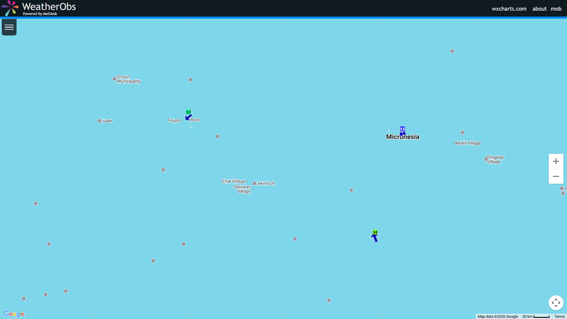
Invest 90W is still a broad disturbance within the Near-Equatorial
Trough (NET) between Pohnpei and Chuuk. The Joint Typhoon Warning
Center has Invest 90W center near 4N155E, tracking a broad
circulation, but satellite imagery shows a mid-level and potential
surface circulation further north near 8N155E. Multiple circulations
are always possible during the early stages of systems trying to
develop before they organize around a clearly defined center. This
may indicate that Invest 90W will take a couple of days to
consolidate. Invest 90W is helping to produce numerous locally heavy
showers, and isolated thunderstorms around the islands of Chuuk,
Pohnpei and Kosrae. Gusty winds are possible in this convection,
especially as a trade-wind surge continues across the region near and
to north of the main islands of Chuuk, Pohnpei, Kosrae. Invest 90W
is expected to shift northwest over the next few days with
development currently expected to be gradual, so while development
into a significant tropical cyclone (Tropical Depression) is not
likely over the next couple of days, models guidance do support
Invest 90W eventually developing into a tropical cyclone. The exact
timing and eventual track is still uncertain and it is not clear
whether Invest 90W will head directly towards the Marianas or track
more northeast or south of the Marianas. Global ensemble models have
shown a more southerly trend in the potential track today, but the
AIGFS and EC-AIFS still shows a northerly turn that has Invest 90W
passing east of the Marianas. For now, the Marianas have the
potential for increasing showers, thunderstorms, and gusty winds
developing over the weekend or early next week and should monitor the
forecast for updates as Invest 90W develops
0 likes
Visit the Caribbean-Central America Weather Thread where you can find at first post web cams,radars
and observations from Caribbean basin members Click Here
and observations from Caribbean basin members Click Here
-
mrbagyo
- Category 5
- Posts: 3982
- Age: 33
- Joined: Thu Apr 12, 2012 9:18 am
- Location: 14.13N 120.98E
- Contact:
Re: WPAC: INVEST 90W
nice twin circulation on opposite hemisphere

1 likes
The posts in this forum are NOT official forecast and should not be used as such. They are just the opinion of the poster and may or may not be backed by sound meteorological data. They are NOT endorsed by any professional institution or storm2k.org. For official information, please refer to RSMC, NHC and NWS products.
-
cycloneye
- Admin
- Posts: 149666
- Age: 69
- Joined: Thu Oct 10, 2002 10:54 am
- Location: San Juan, Puerto Rico
Re: WPAC: INVEST 90W
JTWC has medium chance for next 24 hours.
AN AREA OF CONVECTION (INVEST 90W) HAS PERSISTED NEAR 9.2N
155.4E, APPROXIMATELY 234 NM WEST-SOUTHWEST OF CHUUK. ANIMATED
ENHANCED INFRARED SATELLITE IMAGERY DEPICT A BROAD AREA OF CYCLONIC
TURNING WITH DENSE FLARING CONVECTION OBSCURING THE LOW LEVEL CENTER.
THE POSITION IS BASED ON THE CENTROID OF THE OVERALL CIRCULATION AND
PROMINENT MID-LEVEL FLOW. ENVIRONMENTAL ANALYSIS INDICATES 90W IS
CURRENTLY IN A FAVORABLE ENVIRONMENT FOR DEVELOPMENT BEING CENTERED IN
A LOWER POCKET (10-15 KT) OF VERTICAL WIND SHEAR, WARM (29-30 C) SEA
SURFACE TEMPERATURES, AND A POINT SOURCE JUST EAST ASSISTING WITH
MODERATE POLEWARD OUTFLOW. GLOBAL MODELS ARE IN GOOD AGREEMENT ON A
WESTWARD TRACK WITH INTENSIFICATION OVER THE NEXT 24-48 HOURS. MAXIMUM
SUSTAINED SURFACE WINDS ARE ESTIMATED AT 13 TO 18 KNOTS. MINIMUM SEA
LEVEL PRESSURE IS ESTIMATED TO BE NEAR 1002 MB. THE POTENTIAL FOR THE
DEVELOPMENT OF A SIGNIFICANT TROPICAL CYCLONE WITHIN THE NEXT 24 HOURS
IS MEDIUM.
0 likes
Visit the Caribbean-Central America Weather Thread where you can find at first post web cams,radars
and observations from Caribbean basin members Click Here
and observations from Caribbean basin members Click Here
-
cycloneye
- Admin
- Posts: 149666
- Age: 69
- Joined: Thu Oct 10, 2002 10:54 am
- Location: San Juan, Puerto Rico
Re: WPAC: INVEST 90W

1 likes
Visit the Caribbean-Central America Weather Thread where you can find at first post web cams,radars
and observations from Caribbean basin members Click Here
and observations from Caribbean basin members Click Here
Re: WPAC: 90W - Tropical Depression

TD a
Issued at 2026/04/08 13:25 UTC
Analysis at 04/08 12 UTC
Grade TD
Scale -
Intensity -
Center position N8°20′ (8.3°)
E154°10′ (154.2°)
Direction and speed of movement Almost stationary
Central pressure 1004 hPa
Maximum sustained wind speed near center 15 m/s (30 kt)
Maximum wind gust speed 23 m/s (45 kt)
Forecast for 04/09 12 UTC
Grade TS
Intensity -
Center position of probability circle N8°30′ (8.5°)
E151°50′ (151.8°)
Direction and speed of movement W 10 km/h (6 kt)
Central pressure 998 hPa
Maximum sustained wind speed near center 18 m/s (35 kt)
Maximum wind gust speed 25 m/s (50 kt)
Radius of probability circle 130 km (70 NM)
Forecast for 04/10 12 UTC
Grade TS
Intensity -
Center position of probability circle N9°05′ (9.1°)
E150°20′ (150.3°)
Direction and speed of movement WNW Slow
Central pressure 990 hPa
Maximum sustained wind speed near center 23 m/s (45 kt)
Maximum wind gust speed 35 m/s (65 kt)
Radius of probability circle 200 km (110 NM)
Forecast for 04/11 12 UTC
Grade STS
Intensity -
Center position of probability circle N9°30′ (9.5°)
E149°25′ (149.4°)
Direction and speed of movement Almost stationary
Central pressure 980 hPa
Maximum sustained wind speed near center 30 m/s (55 kt)
Maximum wind gust speed 40 m/s (80 kt)
Radius of probability circle 260 km (140 NM)
Radius of storm warning area 350 km (190 NM)
Forecast for 04/12 12 UTC
Grade TY
Intensity -
Center position of probability circle N10°35′ (10.6°)
E147°05′ (147.1°)
Direction and speed of movement WNW 10 km/h (6 kt)
Central pressure 965 hPa
Maximum sustained wind speed near center 35 m/s (70 kt)
Maximum wind gust speed 50 m/s (100 kt)
Radius of probability circle 330 km (180 NM)
Radius of storm warning area 440 km (240 NM)
Forecast for 04/13 12 UTC
Grade TY
Intensity -
Center position of probability circle N11°55′ (11.9°)
E144°10′ (144.2°)
Direction and speed of movement WNW 15 km/h (8 kt)
Central pressure 955 hPa
Maximum sustained wind speed near center 40 m/s (80 kt)
Maximum wind gust speed 60 m/s (115 kt)
Radius of probability circle 440 km (240 NM)
Radius of storm warning area 600 km (330 NM)
1 likes
ヤンデレ女が寝取られるているのを見たい!!!
ECMWF ensemble NWPAC plots: https://ecmwfensnwpac.imgbb.com/
Multimodel NWPAC plots: https://multimodelnwpac.imgbb.com/
GFS Ensemble NWPAC plots (16 & 35 day forecast): https://gefsnwpac.imgbb.com/
Plots updated automatically
ECMWF ensemble NWPAC plots: https://ecmwfensnwpac.imgbb.com/
Multimodel NWPAC plots: https://multimodelnwpac.imgbb.com/
GFS Ensemble NWPAC plots (16 & 35 day forecast): https://gefsnwpac.imgbb.com/
Plots updated automatically
Return to “Active Storms - WestPAC/Asia”
Who is online
Users browsing this forum: Google [Bot] and 56 guests