https://x.com/i/status/2043285082451202465
WPAC: SINLAKU - Typhoon
Moderators: S2k Moderators, WesternPacificWeatherMods
Forum rules

The posts in this forum are NOT official forecast and should not be used as such. They are just the opinion of the poster and may or may not be backed by sound meteorological data. They are NOT endorsed by any professional institution or STORM2K.
-
Hurricane2022

- Category 5

- Posts: 2083
- Joined: Tue Aug 23, 2022 11:38 pm
- Location: Araçatuba, Brazil
Re: WPAC: SINLAKU - Typhoon
0 likes
Sorry for the bad English sometimes...!
For reliable and detailed information for any meteorological phenomenon, please consult the National Hurricane Center, Joint Typhoon Warning Center , or your local Meteo Center.
--------
ECCE OMNIA NOVA FACIAM (Ap 21,5).
For reliable and detailed information for any meteorological phenomenon, please consult the National Hurricane Center, Joint Typhoon Warning Center , or your local Meteo Center.
--------
ECCE OMNIA NOVA FACIAM (Ap 21,5).
-
cycloneye

- Admin

- Posts: 149666
- Age: 69
- Joined: Thu Oct 10, 2002 10:54 am
- Location: San Juan, Puerto Rico
Re: WPAC: SINLAKU - Typhoon

0 likes
Visit the Caribbean-Central America Weather Thread where you can find at first post web cams,radars
and observations from Caribbean basin members Click Here
and observations from Caribbean basin members Click Here
-
cycloneye
- Admin
- Posts: 149666
- Age: 69
- Joined: Thu Oct 10, 2002 10:54 am
- Location: San Juan, Puerto Rico
Re: WPAC: SINLAKU - Typhoon
Josh will not chase it as logistics are a problem in those islands.
https://x.com/iCyclone/status/2043307141499363558
https://x.com/iCyclone/status/2043307141499363558
0 likes
Visit the Caribbean-Central America Weather Thread where you can find at first post web cams,radars
and observations from Caribbean basin members Click Here
and observations from Caribbean basin members Click Here
-
cycloneye
- Admin
- Posts: 149666
- Age: 69
- Joined: Thu Oct 10, 2002 10:54 am
- Location: San Juan, Puerto Rico
Re: WPAC: SINLAKU - Typhoon
A. 04W (SINLAKU)
B. 12/1130Z
C. 10.9N
D. 150.3E
E. ONE/HIMAWARI-9
F. T7.5/7.5
G. IR/EIR/SWIR
H. REMARKS...WMG EYE SURROUNDED BY CDG RING AND EMBEDDED IN CMG YIELDS
A DT OF 7.5 AFTER ADDING 1.0 FOR EYE ADJUSTMENT. THE MET IS 6.0 BASED
ON A 24HR RAPID DEVELOPING TREND. THE PT IS 6.5. THE FT IS BASED ON THE
6 HOUR AVERAGE DT OF 7.5 WHICH JUSTIFIES BREAKING CONTRAINTS.
0 likes
Visit the Caribbean-Central America Weather Thread where you can find at first post web cams,radars
and observations from Caribbean basin members Click Here
and observations from Caribbean basin members Click Here
-
Hurricane2022
- Category 5
- Posts: 2083
- Joined: Tue Aug 23, 2022 11:38 pm
- Location: Araçatuba, Brazil
Re: WPAC: SINLAKU - Typhoon
JMA now only at 105/920. But it's better than nothing still 
0 likes
Sorry for the bad English sometimes...!
For reliable and detailed information for any meteorological phenomenon, please consult the National Hurricane Center, Joint Typhoon Warning Center , or your local Meteo Center.
--------
ECCE OMNIA NOVA FACIAM (Ap 21,5).
For reliable and detailed information for any meteorological phenomenon, please consult the National Hurricane Center, Joint Typhoon Warning Center , or your local Meteo Center.
--------
ECCE OMNIA NOVA FACIAM (Ap 21,5).
-
Hurricane2022
- Category 5
- Posts: 2083
- Joined: Tue Aug 23, 2022 11:38 pm
- Location: Araçatuba, Brazil
Re: WPAC: SINLAKU - Typhoon
0 likes
Sorry for the bad English sometimes...!
For reliable and detailed information for any meteorological phenomenon, please consult the National Hurricane Center, Joint Typhoon Warning Center , or your local Meteo Center.
--------
ECCE OMNIA NOVA FACIAM (Ap 21,5).
For reliable and detailed information for any meteorological phenomenon, please consult the National Hurricane Center, Joint Typhoon Warning Center , or your local Meteo Center.
--------
ECCE OMNIA NOVA FACIAM (Ap 21,5).

Re: WPAC: SINLAKU - Typhoon
04W SINLAKU 260412 1200 11.1N 150.2E WPAC 150 902
0 likes
ヤンデレ女が寝取られるているのを見たい!!!
ECMWF ensemble NWPAC plots: https://ecmwfensnwpac.imgbb.com/
Multimodel NWPAC plots: https://multimodelnwpac.imgbb.com/
GFS Ensemble NWPAC plots (16 & 35 day forecast): https://gefsnwpac.imgbb.com/
Plots updated automatically
ECMWF ensemble NWPAC plots: https://ecmwfensnwpac.imgbb.com/
Multimodel NWPAC plots: https://multimodelnwpac.imgbb.com/
GFS Ensemble NWPAC plots (16 & 35 day forecast): https://gefsnwpac.imgbb.com/
Plots updated automatically
-
Hurricane2022
- Category 5
- Posts: 2083
- Joined: Tue Aug 23, 2022 11:38 pm
- Location: Araçatuba, Brazil
Re: WPAC: SINLAKU - Typhoon
https://x.com/i/status/2043305601384751201
"Hurricane Melissa (2025), which had a central pressure of 893 hPa according to aircraft observations, and Typhoon No. 4 at 10Z on the 12th. Both maps use a 1-degree grid and the same color scheme"
0 likes
Sorry for the bad English sometimes...!
For reliable and detailed information for any meteorological phenomenon, please consult the National Hurricane Center, Joint Typhoon Warning Center , or your local Meteo Center.
--------
ECCE OMNIA NOVA FACIAM (Ap 21,5).
For reliable and detailed information for any meteorological phenomenon, please consult the National Hurricane Center, Joint Typhoon Warning Center , or your local Meteo Center.
--------
ECCE OMNIA NOVA FACIAM (Ap 21,5).
-
Hurricane2022
- Category 5
- Posts: 2083
- Joined: Tue Aug 23, 2022 11:38 pm
- Location: Araçatuba, Brazil
Re: WPAC: SINLAKU - Typhoon
Hayabusa wrote:04W SINLAKU 260412 1200 11.1N 150.2E WPAC 150 902
https://x.com/i/status/2043307981094232526
0 likes
Sorry for the bad English sometimes...!
For reliable and detailed information for any meteorological phenomenon, please consult the National Hurricane Center, Joint Typhoon Warning Center , or your local Meteo Center.
--------
ECCE OMNIA NOVA FACIAM (Ap 21,5).
For reliable and detailed information for any meteorological phenomenon, please consult the National Hurricane Center, Joint Typhoon Warning Center , or your local Meteo Center.
--------
ECCE OMNIA NOVA FACIAM (Ap 21,5).
Re: WPAC: SINLAKU - Typhoon
CURRENT ESTIMATE
Date (mmddhhmm): 04120850
SATCON: MSLP = 908 hPa MSW = 158 knots
SATCON Member Consensus: 150.0 knots
Pressure -> Wind Using SATCON MSLP: 147 knots
Distance to Outer Closed Isobar Used is 425 nm
Eye Size Correction Used is 4.1 knots Source: MW
Member Estimates
ADT: 896 hPa 153.587523599573 knots Scene: CDO Date: APR121000
CIMSS AMSU: 982 hPa 72 knots Bias Corr: 0 (MW) Date: 04111133
ATMS: 924.1 hPa 117.8 knots Date: 04120311
SSMIS: 918.0 hPa 146.0 knots Date: 04120850
CIRA ATMS: hPa knots Date:
0 likes
ヤンデレ女が寝取られるているのを見たい!!!
ECMWF ensemble NWPAC plots: https://ecmwfensnwpac.imgbb.com/
Multimodel NWPAC plots: https://multimodelnwpac.imgbb.com/
GFS Ensemble NWPAC plots (16 & 35 day forecast): https://gefsnwpac.imgbb.com/
Plots updated automatically
ECMWF ensemble NWPAC plots: https://ecmwfensnwpac.imgbb.com/
Multimodel NWPAC plots: https://multimodelnwpac.imgbb.com/
GFS Ensemble NWPAC plots (16 & 35 day forecast): https://gefsnwpac.imgbb.com/
Plots updated automatically
-
mrbagyo

- Category 5
- Posts: 3982
- Age: 33
- Joined: Thu Apr 12, 2012 9:18 am
- Location: 14.13N 120.98E
- Contact:
Re: WPAC: SINLAKU - Typhoon
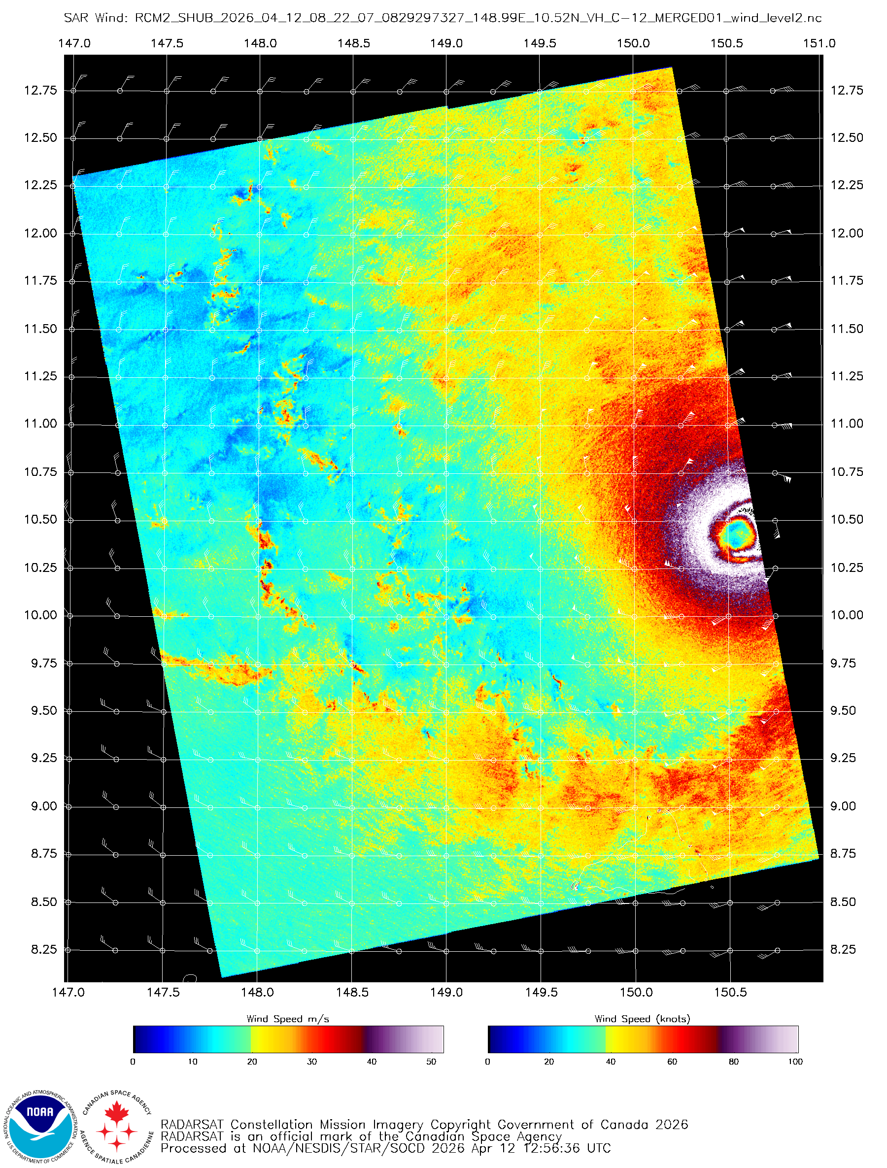
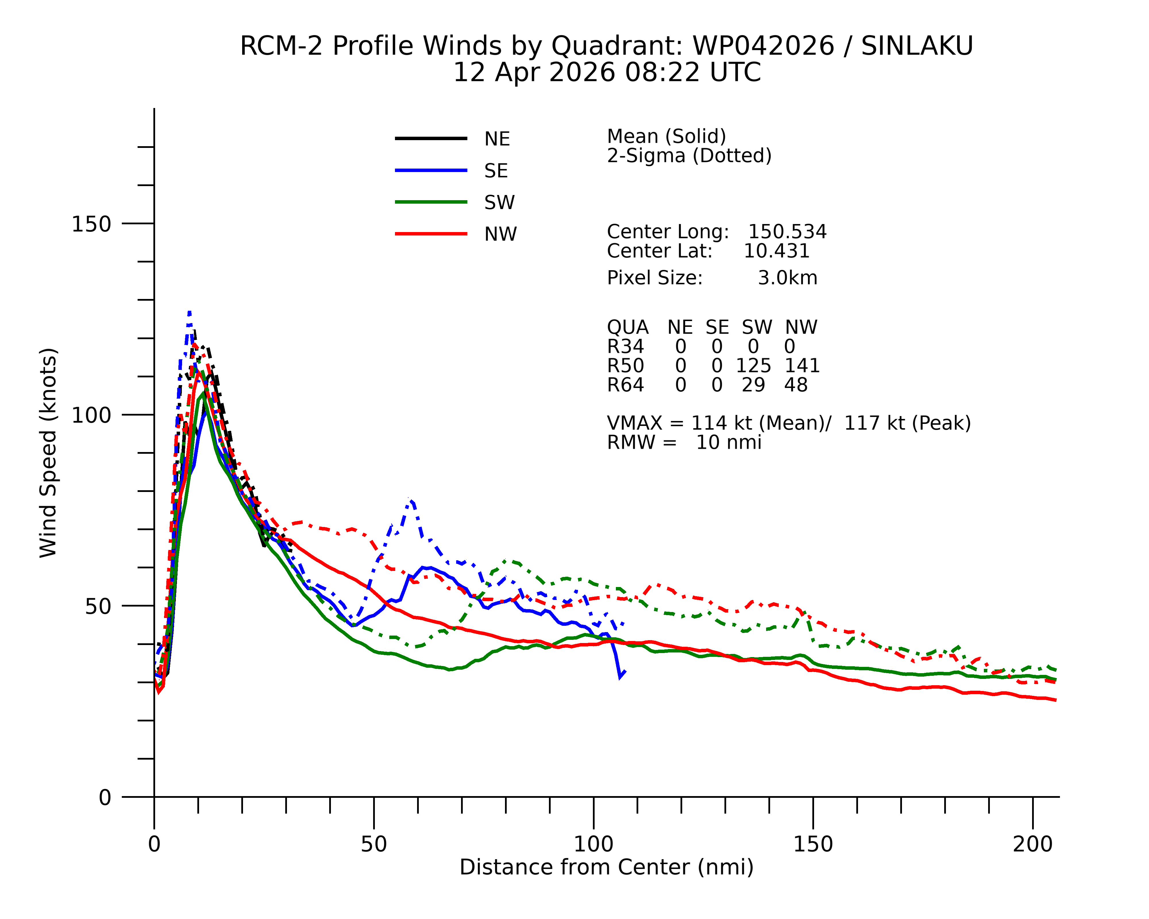
peak wind on SAR is 117 knots (not a full pass)
0 likes
The posts in this forum are NOT official forecast and should not be used as such. They are just the opinion of the poster and may or may not be backed by sound meteorological data. They are NOT endorsed by any professional institution or storm2k.org. For official information, please refer to RSMC, NHC and NWS products.
-
Hurricane2022
- Category 5
- Posts: 2083
- Joined: Tue Aug 23, 2022 11:38 pm
- Location: Araçatuba, Brazil
Re: WPAC: SINLAKU - Typhoon
0 likes
Sorry for the bad English sometimes...!
For reliable and detailed information for any meteorological phenomenon, please consult the National Hurricane Center, Joint Typhoon Warning Center , or your local Meteo Center.
--------
ECCE OMNIA NOVA FACIAM (Ap 21,5).
For reliable and detailed information for any meteorological phenomenon, please consult the National Hurricane Center, Joint Typhoon Warning Center , or your local Meteo Center.
--------
ECCE OMNIA NOVA FACIAM (Ap 21,5).
-
Hurricane2022
- Category 5
- Posts: 2083
- Joined: Tue Aug 23, 2022 11:38 pm
- Location: Araçatuba, Brazil
Re: WPAC: SINLAKU - Typhoon
Likely peaking at around 155 - 160 kts

1 likes
Sorry for the bad English sometimes...!
For reliable and detailed information for any meteorological phenomenon, please consult the National Hurricane Center, Joint Typhoon Warning Center , or your local Meteo Center.
--------
ECCE OMNIA NOVA FACIAM (Ap 21,5).
For reliable and detailed information for any meteorological phenomenon, please consult the National Hurricane Center, Joint Typhoon Warning Center , or your local Meteo Center.
--------
ECCE OMNIA NOVA FACIAM (Ap 21,5).


Re: WPAC: SINLAKU - Typhoon
I think, based on a blend of subjective estimates around T8.0 (170 kt) and objective estimates a little lower at T7.7 (161 kt) from UW-CIMSS, a current intensity of 160~165 kt is plausible. CKZ yields a central pressure of 889~882 hPa for that range. Truly a stunning cyclone & a hell of a first typhoon for the 2026 WPAC season.
0 likes
-
Yellow Evan

- Professional-Met

- Posts: 16255
- Age: 27
- Joined: Fri Jul 15, 2011 12:48 pm
- Location: Henderson, Nevada/Honolulu, HI
- Contact:

Re: WPAC: SINLAKU - Typhoon
Any deterioration since the peak Δ between eye temperature and CDO temperature - about 6 hours ago - has been minimal. Still sitting comfortably above Δ100°C. The CDG ring has frayed and thinned somewhat but remains unbroken, so if you're willing to apply unofficial CDG rules, this remains at T8.0 (170 kt), or T7.5 (155 kt) otherwise. The question is how long this peak can be maintained & how quickly it will weaken afterwards, with Sinlaku expected to impact or pass very close to Tinian and Saipan overnight sometime Tuesday morning (0z~12z on the 14th). JTWC expects it to have weakened by 10~15 kt, but their intensity estimate is 5 kt lower than their own satellite fixes would indicate, and 15 kt lower than ADT CI. It is of course entirely possible that Sinlaku will be down to 135 kt or lower in 36~48 hours, given that it seems to be passing its peak, though a successful ERC in that time would mean a larger wind field.
A NWS typhoon warning is in place:
...but "winds of 75 kt or greater" seems like an understatement of the risk when populated areas of Tinian and Saipan could very well catch some of the eyewall.
A NWS typhoon warning is in place:
..TYPHOON WARNING REMAINS IN EFFECT...
* WHAT...Typhoon Warning. Tropical storm force winds of 40 to
60 kt are expected as early as late Monday afternoon, with
typhoon force winds of 75 kt or greater as early as Tuesday
morning. Seas are building to 30 feet or more by Tuesday.
* WHERE...Rota, Tinian and Saipan Coastal Waters.
* WHAT...Typhoon Warning. Tropical storm force winds of 40 to
60 kt are expected as early as late Monday afternoon, with
typhoon force winds of 75 kt or greater as early as Tuesday
morning. Seas are building to 30 feet or more by Tuesday.
* WHERE...Rota, Tinian and Saipan Coastal Waters.
...but "winds of 75 kt or greater" seems like an understatement of the risk when populated areas of Tinian and Saipan could very well catch some of the eyewall.
1 likes
Re: WPAC: SINLAKU - Typhoon
JMA 15z intensifies again
T2604(Sinlaku)
Issued at 2026/04/12 15:45 UTC
Analysis at 04/12 15 UTC
Grade TY
Scale Large
Intensity Violent
Center position N11°20′ (11.3°)
E149°55′ (149.9°)
Direction and speed of movement NNW 15 km/h (8 kt)
Central pressure 910 hPa
Maximum sustained wind speed near center 55 m/s (110 kt)
Maximum wind gust speed 80 m/s (155 kt)
Radius of 50-kt wind area 150 km (80 NM)
Radius of 30-kt wind area NE600 km (325 NM)
SW500 km (270 NM)
2 likes
ヤンデレ女が寝取られるているのを見たい!!!
ECMWF ensemble NWPAC plots: https://ecmwfensnwpac.imgbb.com/
Multimodel NWPAC plots: https://multimodelnwpac.imgbb.com/
GFS Ensemble NWPAC plots (16 & 35 day forecast): https://gefsnwpac.imgbb.com/
Plots updated automatically
ECMWF ensemble NWPAC plots: https://ecmwfensnwpac.imgbb.com/
Multimodel NWPAC plots: https://multimodelnwpac.imgbb.com/
GFS Ensemble NWPAC plots (16 & 35 day forecast): https://gefsnwpac.imgbb.com/
Plots updated automatically

Re: WPAC: SINLAKU - Typhoon
Typhoon Message
20260412 23:37
National Meteorological Center No.119
Analysis Time: Apr. 12th 15 UTC
Name of TC: SINLAKU
Num. of TC: 2604
Current Location: 11.3°N 149.8°E
2-min. Average Max. Wind Speed: 70m/s(252km/h)
Central Pressure: 900hPa
Radius of 34knots Winds: NE 400km SE 380km SW 380km NW 400km
Radius of 50knots Winds: NE 120km SE 120km SW 120km NW 120km
Radius of 64knots Winds: NE 80km SE 80km SW 80km NW 80km
Forecast movement:next 24hrs SINLAKU will moving NW at speed of 17km/h

1 likes
-
Hurricane2022
- Category 5
- Posts: 2083
- Joined: Tue Aug 23, 2022 11:38 pm
- Location: Araçatuba, Brazil
Re: WPAC: SINLAKU - Typhoon

2 likes
Sorry for the bad English sometimes...!
For reliable and detailed information for any meteorological phenomenon, please consult the National Hurricane Center, Joint Typhoon Warning Center , or your local Meteo Center.
--------
ECCE OMNIA NOVA FACIAM (Ap 21,5).
For reliable and detailed information for any meteorological phenomenon, please consult the National Hurricane Center, Joint Typhoon Warning Center , or your local Meteo Center.
--------
ECCE OMNIA NOVA FACIAM (Ap 21,5).
Return to “Active Storms - WestPAC/Asia”
Who is online
Users browsing this forum: Google [Bot] and 56 guests