ATL: EMILY - Remnants

Moderator: S2k Moderators

Message
Author
User avatar
Ptarmigan
Category 5
Category 5
Posts: 5319
Joined: Wed Aug 16, 2006 9:06 pm

Re: ATL: EMILY - Tropical Storm - Discussion

#5401 Postby Ptarmigan » Tue Aug 02, 2011 10:31 pm

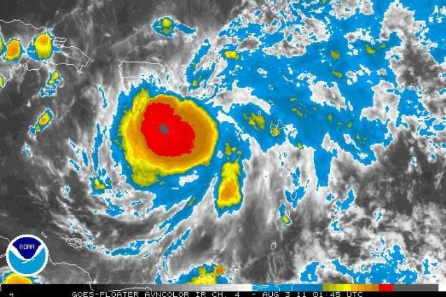
ozonepete wrote:Wow, CDO getting really impressive. The strongest it's had yet.

http://i189.photobucket.com/albums/z174 ... 030145.jpg


Looks like it is getting better organized since it is more circular.

Personal Forecast Disclaimer:
The posts in this forum are NOT official forecast and should not be used as such. They are just the opinion of the poster and may or may not be backed by sound meteorological data. They are NOT endorsed by any professional institution or storm2k.org. For official information, please refer to the NHC and NWS products.
0 likes   

ozonepete
Professional-Met
Professional-Met
Posts: 4743
Joined: Mon Sep 07, 2009 3:23 pm
Location: From Ozone Park, NYC / Now in Brooklyn, NY

Re: ATL: EMILY - Tropical Storm - Discussion

#5402 Postby ozonepete » Tue Aug 02, 2011 10:33 pm

Don't know for sure, but I'm just sayin', the convection to the west of Emily is really blowing off to the north now. That often indicates a pretty good turn to the north is coming.
0 likes   

User avatar
HURAKAN
Professional-Met
Professional-Met
Posts: 46086
Age: 38
Joined: Thu May 20, 2004 4:34 pm
Location: Key West, FL
Contact:

#5403 Postby HURAKAN » Tue Aug 02, 2011 10:34 pm

Don't let the satellite images fool you.

Buoy 42059 ... 15.1ºN 67.5ºW

42059 - MARITIME-buoy
Wednesday Aug. 3 - 2:50 UTC
Air Temperature: 82°F
Dewpoint: 78°F
Wind: S at 7 mph
gusting to 7
Pressure: 1008.7 mb
Weather: Clear
Wave Height: 8 ft
Sea Surface Temp: 84.2°F
0 likes   

User avatar
Ptarmigan
Category 5
Category 5
Posts: 5319
Joined: Wed Aug 16, 2006 9:06 pm

Re:

#5404 Postby Ptarmigan » Tue Aug 02, 2011 10:37 pm

HURAKAN wrote:Don't let the satellite images fool you.

Buoy 42059 ... 15.1ºN 67.5ºW

42059 - MARITIME-buoy
Wednesday Aug. 3 - 2:50 UTC
Air Temperature: 82°F
Dewpoint: 78°F
Wind: S at 7 mph
gusting to 7
Pressure: 1008.7 mb
Weather: Clear
Wave Height: 8 ft
Sea Surface Temp: 84.2°F


True. Satellite does not tell everything.
0 likes   

User avatar
cycloneye
Admin
Admin
Posts: 146106
Age: 69
Joined: Thu Oct 10, 2002 10:54 am
Location: San Juan, Puerto Rico

Re: ATL: EMILY - Tropical Storm - Discussion

#5405 Postby cycloneye » Tue Aug 02, 2011 10:38 pm

Recent ASCAT pass between 9:00 PM-10:00 PM shows a open trough rather than a well defined circulation. What a weird system this has been since it left Africa.

Image

Uploaded by imageshack.us
0 likes   
Visit the Caribbean-Central America Weather Thread where you can find at first post web cams,radars
and observations from Caribbean basin members Click Here

ozonepete
Professional-Met
Professional-Met
Posts: 4743
Joined: Mon Sep 07, 2009 3:23 pm
Location: From Ozone Park, NYC / Now in Brooklyn, NY

Re:

#5406 Postby ozonepete » Tue Aug 02, 2011 10:41 pm

HURAKAN wrote:Don't let the satellite images fool you.

Buoy 42059 ... 15.1ºN 67.5ºW

42059 - MARITIME-buoy
Wednesday Aug. 3 - 2:50 UTC
Air Temperature: 82°F
Dewpoint: 78°F
Wind: S at 7 mph
gusting to 7
Pressure: 1008.7 mb
Weather: Clear
Wave Height: 8 ft
Sea Surface Temp: 84.2°F


Yes, my friend, but that buoy is on the weaker side. The strongest winds have been to the north. Also, I was more just talking about the intense squalls in the CDO, and that it looks like it will expand over southern and especially western PR very soon. I'm thinking flooding. I mean, wow, look at the size of this rapidly expanding convection.

Image
0 likes   

ozonepete
Professional-Met
Professional-Met
Posts: 4743
Joined: Mon Sep 07, 2009 3:23 pm
Location: From Ozone Park, NYC / Now in Brooklyn, NY

Re: ATL: EMILY - Tropical Storm - Discussion

#5407 Postby ozonepete » Tue Aug 02, 2011 10:44 pm

cycloneye wrote:Recent ASCAT pass between 9:00 PM-10:00 PM shows a open trough rather than a well defined circulation. What a weird system this has been since it left Africa.

Image

Uploaded by imageshack.us


Hey cyclone,
I think it's the second number that indicates the time. I believe it was taken at 08/02 at 18Z.
0 likes   

User avatar
Bocadude85
Category 5
Category 5
Posts: 2990
Age: 38
Joined: Mon Apr 18, 2005 2:20 pm
Location: Honolulu,Hi

Re: ATL: EMILY - Tropical Storm - Discussion

#5408 Postby Bocadude85 » Tue Aug 02, 2011 10:46 pm

Looks like maybe she is starting to make her turn?

http://www.ssd.noaa.gov/goes/flt/t2/flash-rb.html

Nevermind looks like the convection is starting to expand west now..
Last edited by Bocadude85 on Tue Aug 02, 2011 10:51 pm, edited 1 time in total.
0 likes   

User avatar
cycloneye
Admin
Admin
Posts: 146106
Age: 69
Joined: Thu Oct 10, 2002 10:54 am
Location: San Juan, Puerto Rico

Re: ATL: EMILY - Tropical Storm - Discussion

#5409 Postby cycloneye » Tue Aug 02, 2011 10:49 pm

Hey cyclone,
I think it's the second number that indicates the time. I believe it was taken at 08/02 at 18Z.


The numbers I see are 0124-0125-0126-0127
0 likes   
Visit the Caribbean-Central America Weather Thread where you can find at first post web cams,radars
and observations from Caribbean basin members Click Here

User avatar
Evil Jeremy
S2K Supporter
S2K Supporter
Posts: 5463
Age: 32
Joined: Mon Apr 10, 2006 2:10 pm
Location: Los Angeles, CA

#5410 Postby Evil Jeremy » Tue Aug 02, 2011 10:49 pm

00z GFS running. Through 24 hours, both the storm and ridge are stronger than on the previous run, but Emily is following the same track.

EDIT: Wrong thread, whoops!
Last edited by Evil Jeremy on Tue Aug 02, 2011 10:50 pm, edited 1 time in total.
0 likes   
Frances 04 / Jeanne 04 / Katrina 05 / Wilma 05 / Fay 08 / Debby 12 / Andrea 13 / Colin 16 / Hermine 16 / Matthew 16 / Irma 17

Aric Dunn
Category 5
Category 5
Posts: 21238
Age: 42
Joined: Sun Sep 19, 2004 9:58 pm
Location: Ready for the Chase.
Contact:

#5411 Postby Aric Dunn » Tue Aug 02, 2011 10:50 pm

the south winds at that bouy means the center is farther west than the NHC position

which means its south of the forecast track.. again ..
Last edited by Aric Dunn on Tue Aug 02, 2011 10:50 pm, edited 1 time in total.
0 likes   
Note: If I make a post that is brief. Please refer back to previous posts for the analysis or reasoning. I do not re-write/qoute what my initial post said each time.
If there is nothing before... then just ask :)

Space & Atmospheric Physicist, Embry-Riddle Aeronautical University,
I believe the sky is falling...

User avatar
viberama
Tropical Depression
Tropical Depression
Posts: 65
Age: 52
Joined: Mon Aug 01, 2011 7:36 pm
Location: Orlando, FL
Contact:

Re: ATL: EMILY - Tropical Storm - Discussion

#5412 Postby viberama » Tue Aug 02, 2011 10:50 pm

Hi I'm new here but I've been lurking for a while:

Still looks to me like a Westward direction but it has to curve pretty soon doesn't it?
0 likes   
The following post is NOT an official forecast and should not be used as such. It is just my opinion and may or may not be backed by sound meteorological data. For Official Information please refer to the NHC and NWS products

User avatar
Evil Jeremy
S2K Supporter
S2K Supporter
Posts: 5463
Age: 32
Joined: Mon Apr 10, 2006 2:10 pm
Location: Los Angeles, CA

#5413 Postby Evil Jeremy » Tue Aug 02, 2011 10:50 pm

00z GFS running. Through 24 hours, both the storm and ridge are stronger than on the previous run, but Emily is following the same track.

36 hours out: West and weaker of the 18z. It makes sense that it's weaker because it goes over more mountains.
0 likes   
Frances 04 / Jeanne 04 / Katrina 05 / Wilma 05 / Fay 08 / Debby 12 / Andrea 13 / Colin 16 / Hermine 16 / Matthew 16 / Irma 17

User avatar
Evil Jeremy
S2K Supporter
S2K Supporter
Posts: 5463
Age: 32
Joined: Mon Apr 10, 2006 2:10 pm
Location: Los Angeles, CA

Re: ATL: EMILY - Tropical Storm - Discussion

#5414 Postby Evil Jeremy » Tue Aug 02, 2011 10:52 pm

Bocadude85 wrote:Looks like maybe she is starting to make her turn?

http://www.ssd.noaa.gov/goes/flt/t2/flash-rb.html

Nevermind looks like the convection is starting to expand west now..


Could be an illusion. As disorganized as this is, I would not trust satellite for movement right now. Recon will tell the tale.
0 likes   
Frances 04 / Jeanne 04 / Katrina 05 / Wilma 05 / Fay 08 / Debby 12 / Andrea 13 / Colin 16 / Hermine 16 / Matthew 16 / Irma 17

stormreader

Re: ATL: EMILY - Tropical Storm - Discussion

#5415 Postby stormreader » Tue Aug 02, 2011 10:54 pm

cycloneye wrote:Recent ASCAT pass between 9:00 PM-10:00 PM shows a open trough rather than a well defined circulation. What a weird system this has been since it left Africa.

Image

Uploaded by imageshack.us


Well there you go. Sort of like a Wave-Storm a hybrid. Varying back and forth between one and the other (even with the powerful convective bursts). That being the case I think we would have to expect a more westerly move with the system.
0 likes   

User avatar
SouthDadeFish
Professional-Met
Professional-Met
Posts: 2835
Joined: Thu Sep 23, 2010 2:54 pm
Location: Miami, FL
Contact:

#5416 Postby SouthDadeFish » Tue Aug 02, 2011 10:54 pm

I'm not sure if this thing even has a closed circulation anymore. That ASCAT didn't even hint at any west winds...
0 likes   

User avatar
stormhunter7
Category 2
Category 2
Posts: 763
Joined: Mon May 26, 2008 3:13 pm
Location: Panama City Beach, Florida
Contact:

Re: ATL: EMILY - Models

#5417 Postby stormhunter7 » Tue Aug 02, 2011 10:57 pm

0 likes   
The following post is NOT an official forecast and should not be used as such. It is just the opinion of the poster and may or may not be backed by sound meteorological data. It is NOT endorsed by any professional institution including storm2k.org For Official Information please refer to the NHC and NWS products. http://www.nhc.noaa.gov

User avatar
hurricanefloyd5
Category 5
Category 5
Posts: 1659
Age: 44
Joined: Sun May 02, 2004 10:53 am
Location: Spartanburg
Contact:

Re:

#5418 Postby hurricanefloyd5 » Tue Aug 02, 2011 10:57 pm

Aric Dunn wrote:the south winds at that bouy means the center is farther west than the NHC position

which means its south of the forecast track.. again ..


What dose this mean if this is true? Dose that mean the track would shift over florida or close to the west coast of florida aric?
0 likes   

User avatar
NDG
S2K Supporter
S2K Supporter
Posts: 15463
Joined: Sun Jul 09, 2006 10:14 pm
Location: Orlando, FL

#5419 Postby NDG » Tue Aug 02, 2011 10:58 pm

So far, it looks like 0z gfs is a little west from previous runs.
0 likes   

User avatar
TwisterFanatic
Category 5
Category 5
Posts: 1041
Joined: Mon Jun 28, 2010 12:43 pm
Location: Sallisaw, Oklahoma

#5420 Postby TwisterFanatic » Tue Aug 02, 2011 10:58 pm

GFS further south this time, hugging the Cuban coast like the NAM did.
0 likes   
Personal Forecast Disclaimer:
The posts in this forum are NOT official forecast and should not be used as such. They are just the opinion of the poster and may or may not be backed by sound meteorological data. They are NOT endorsed by any professional institution or storm2k.org. For official information, please refer to the NHC and NWS products.


Return to “2011”

Who is online

Users browsing this forum: No registered users and 25 guests