ATL: EMILY - Remnants
Moderator: S2k Moderators
-
ozonepete
- Professional-Met

- Posts: 4743
- Joined: Mon Sep 07, 2009 3:23 pm
- Location: From Ozone Park, NYC / Now in Brooklyn, NY
Re: ATL: EMILY - Tropical Storm - Discussion
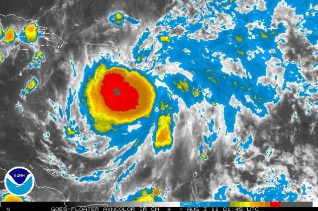
Wow, CDO getting really impressive. The strongest it's had yet.
0 likes
-
AdamFirst

- S2K Supporter

- Posts: 2490
- Age: 36
- Joined: Thu Aug 14, 2008 10:54 am
- Location: Port Saint Lucie, FL
Re: ATL: EMILY - Tropical Storm - Discussion
11 PM Disco:
OVERALL THE ENVIRONMENT
APPEARS FAVORABLE FOR SOME CONTINUED STRENGTHENING UNTIL THE
CYCLONE REACHES HISPANIOLA IN ABOUT 24 HOURS...AND THE OFFICIAL
FORECAST HAS BEEN ADJUSTED UPWARD A BIT IN AGREEMENT WITH THE IVCN
INTENSITY CONSENSUS THROUGH THAT TIME.
___
THE BIGGEST CHANGE IN THE GUIDANCE FOR THIS CYCLE IS THAT
THE GFDL AND HWRF NOW SHOW A LITTLE MORE RIDGING EAST OF EMILY LATE
IN THE PERIOD AND HAVE SHIFTED THEIR TRACKS WESTWARD...ESPECIALLY
AT DAYS 3 AND 4. THROUGH THE FIRST 36 HOURS...THE NEW NHC FORECAST
IS ALONG THE OLD TRACK...BUT A LITTLE FASTER AS IT TRENDS TOWARD
THE FASTER MULTI-MODEL CONSENSUS. FROM 48 TO 96 HOURS...THE NEW
NHC FORECAST HAS BEEN ADJUSTED A LITTLE TO THE LEFT OF THE PREVIOUS
PACKAGE...AND NOW LIES TO THE RIGHT OF THE MULTI-MODEL CONSENSUS.
0 likes
Dolphins Marlins Canes Golden Panthers HEAT
Andrew 1992 - Irene 1999 - Frances 2004 - Jeanne 2004 - Wilma 2005 - Fay 2008 - Isaac 2012 - Matthew 2016 - Irma 2017 - Dorian 2019 - Ian 2022 - Nicole 2022 - Milton 2024
Andrew 1992 - Irene 1999 - Frances 2004 - Jeanne 2004 - Wilma 2005 - Fay 2008 - Isaac 2012 - Matthew 2016 - Irma 2017 - Dorian 2019 - Ian 2022 - Nicole 2022 - Milton 2024
-
Evil Jeremy

- S2K Supporter
- Posts: 5463
- Age: 32
- Joined: Mon Apr 10, 2006 2:10 pm
- Location: Los Angeles, CA
From the Discussion:
THE OFFICIAL
FORECAST HAS BEEN ADJUSTED UPWARD A LITTLE FROM THE PREVIOUS
ADVISORY...BUT REMAINS BELOW THE GUIDANCE GIVEN THE UNCERTAINTY IN
HOW EMILY WILL FARE AFTER LAND INTERACTION.
THE BIGGEST CHANGE IN THE GUIDANCE FOR THIS CYCLE IS THAT
THE GFDL AND HWRF NOW SHOW A LITTLE MORE RIDGING EAST OF EMILY LATE
IN THE PERIOD AND HAVE SHIFTED THEIR TRACKS WESTWARD...ESPECIALLY
AT DAYS 3 AND 4. THROUGH THE FIRST 36 HOURS...THE NEW NHC FORECAST
IS ALONG THE OLD TRACK...BUT A LITTLE FASTER AS IT TRENDS TOWARD
THE FASTER MULTI-MODEL CONSENSUS. FROM 48 TO 96 HOURS...THE NEW
NHC FORECAST HAS BEEN ADJUSTED A LITTLE TO THE LEFT OF THE PREVIOUS
PACKAGE...AND NOW LIES TO THE RIGHT OF THE MULTI-MODEL CONSENSUS.
GIVEN THE LARGE CYCLE-TO-CYCLE VARIABILITY SEEN IN THE TRACK
GUIDANCE...UNCERTAINTY IN THE TRACK FORECAST REMAINS LARGER THAN
USUAL BEYOND 48 HOURS.
The word "uncertainty" returns to the Discussion.
0 likes
Frances 04 / Jeanne 04 / Katrina 05 / Wilma 05 / Fay 08 / Debby 12 / Andrea 13 / Colin 16 / Hermine 16 / Matthew 16 / Irma 17

-
ozonepete
- Professional-Met
- Posts: 4743
- Joined: Mon Sep 07, 2009 3:23 pm
- Location: From Ozone Park, NYC / Now in Brooklyn, NY
Re: ATL: EMILY - Tropical Storm - Discussion
Still looks like it's slowed down again. Or I guess that's due to the LLC getting back under the MLC again for the nth time.
0 likes
-
cycloneye

- Admin

- Posts: 148995
- Age: 69
- Joined: Thu Oct 10, 2002 10:54 am
- Location: San Juan, Puerto Rico
Re: ATL: EMILY - Advisories
TROPICAL STORM EMILY DISCUSSION NUMBER 6
NWS NATIONAL HURRICANE CENTER MIAMI FL AL052011
1100 PM AST TUE AUG 02 2011
THE AREA OF COLD CLOUD TOPS HAS EXPANDED OVER THE PAST FEW HOURS IN
A CDO-LIKE PATTERN...HOWEVER A 2157 UTC SSMIS PASS SUGGESTED THAT
THE LOW-LEVEL CENTER REMAINS DISPLACED TO THE WEST OF THE DEEPEST
CONVECTION. DVORAK CURRENT INTENSITY ESTIMATES WERE 3.0...45
KT...FROM TAFB AND SAB AT 00Z...THAT THAT WILL REMAIN THE INTENSITY
FOR THIS ADVISORY PACKAGE. ANOTHER AIR FORCE RESERVE HURRICANE
HUNTER AIRCRAFT IS SCHEDULED TO INVESTIGATE EMILY OVERNIGHT.
UW-CIMSS SATELLITE ANALYSIS SHOWS ABOUT 12 KT OF WESTERLY SHEAR
OVER EMILY...WHICH IS CONSISTENT WITH THE TILTED STRUCTURE OF THE
CYCLONE AND THE LOCATION OF A MID-LEVEL CIRCULATION SEEN IN VELOCITY
DATA FROM THE SAN JUAN DOPPLER RADAR. OVERALL THE ENVIRONMENT
APPEARS FAVORABLE FOR SOME CONTINUED STRENGTHENING UNTIL THE
CYCLONE REACHES HISPANIOLA IN ABOUT 24 HOURS...AND THE OFFICIAL
FORECAST HAS BEEN ADJUSTED UPWARD A BIT IN AGREEMENT WITH THE IVCN
INTENSITY CONSENSUS THROUGH THAT TIME. IF EMILY SURVIVES ITS TRIP
ACROSS THE HIGH TERRAIN OF HISPANIOLA...THE ENVIRONMENT APPEARS
SUPPORTIVE OF RE-INTENSIFICATION LATE IN THE PERIOD. THE OFFICIAL
FORECAST HAS BEEN ADJUSTED UPWARD A LITTLE FROM THE PREVIOUS
ADVISORY...BUT REMAINS BELOW THE GUIDANCE GIVEN THE UNCERTAINTY IN
HOW EMILY WILL FARE AFTER LAND INTERACTION.
THE CENTER HAS BEEN DIFFICULT TO LOCATE THIS EVENING GIVEN THE LACK
OF AIRCRAFT AND MICROWAVE DATA. BASED ON THE ABOVE-MENTIONED SSMIS
PASS...THE CENTER IS ASSUMED TO BE WEST OF THE COLDEST CLOUD TOPS...
YIELDING AN UNCERTAIN INITIAL MOTION ESTIMATE OF 285/12...TOWARD THE
WEST-NORTHWEST. THE SYNOPTIC REASONING REMAINS UNCHANGED...AS A
MID-LEVEL TROUGH WILL REACH MAXIMUM AMPLITUDE OVER THE WESTERN
ATLANTIC IN THE NEXT 24 HOURS...ALLOWING EMILY TO TURN
NORTHWESTWARD AND MOVE ACROSS HISPANIOLA AND INTO THE SOUTHEASTERN
BAHAMAS IN THE NEXT 24 TO 36 HOURS. AFTER THE TROUGH LIFTS OUT A
MID-LEVEL WEAKNESS IS EXPECTED TO PERSIST OVER THE SOUTHWESTERN
ATLANTIC THROUGH THE END OF THE FORECAST PERIOD...AND EMILY SHOULD
TURN NORTHWARD INTO THE WEAKNESS AND EVENTUALLY ACCELERATE
NORTH-NORTHEASTWARD BY DAY 5 AS A RIDGE REBUILDS TO THE SOUTHEAST
OF THE CYCLONE AND A BROAD TROUGH MOVES INTO THE EASTERN UNITED
STATES. THE BIGGEST CHANGE IN THE GUIDANCE FOR THIS CYCLE IS THAT
THE GFDL AND HWRF NOW SHOW A LITTLE MORE RIDGING EAST OF EMILY LATE
IN THE PERIOD AND HAVE SHIFTED THEIR TRACKS WESTWARD...ESPECIALLY
AT DAYS 3 AND 4. THROUGH THE FIRST 36 HOURS...THE NEW NHC FORECAST
IS ALONG THE OLD TRACK...BUT A LITTLE FASTER AS IT TRENDS TOWARD
THE FASTER MULTI-MODEL CONSENSUS. FROM 48 TO 96 HOURS...THE NEW
NHC FORECAST HAS BEEN ADJUSTED A LITTLE TO THE LEFT OF THE PREVIOUS
PACKAGE...AND NOW LIES TO THE RIGHT OF THE MULTI-MODEL CONSENSUS.
GIVEN THE LARGE CYCLE-TO-CYCLE VARIABILITY SEEN IN THE TRACK
GUIDANCE...UNCERTAINTY IN THE TRACK FORECAST REMAINS LARGER THAN
USUAL BEYOND 48 HOURS.
BASED ON THE INCREASE IN FORWARD SPEED WITH THE NEW TRACK FORECAST
...A TROPICAL STORM WARNING HAS BEEN ISSUED FOR THE SOUTHEAST
BAHAMAS AND TURKS AND CAICOS.
FORECAST POSITIONS AND MAX WINDS
INIT 03/0300Z 16.2N 66.7W 45 KT 50 MPH
12H 03/1200Z 17.0N 68.4W 50 KT 60 MPH
24H 04/0000Z 18.4N 70.5W 55 KT 65 MPH...INLAND
36H 04/1200Z 20.2N 72.6W 35 KT 40 MPH...OVER WATER
48H 05/0000Z 22.0N 74.4W 35 KT 40 MPH
72H 06/0000Z 26.0N 77.5W 45 KT 50 MPH
96H 07/0000Z 29.5N 78.5W 55 KT 65 MPH
120H 08/0000Z 33.0N 76.0W 65 KT 75 MPH
$$
FORECASTER BRENNAN
0 likes
Visit the Caribbean-Central America Weather Thread where you can find at first post web cams,radars
and observations from Caribbean basin members Click Here
and observations from Caribbean basin members Click Here
-
Aric Dunn
- Category 5

- Posts: 21238
- Age: 43
- Joined: Sun Sep 19, 2004 9:58 pm
- Location: Ready for the Chase.
- Contact:
really "assumed" ... lol at least they mention its an estimate.. again mostly for continuity with their forecast..i imagine
THE CENTER HAS BEEN DIFFICULT TO LOCATE THIS EVENING GIVEN THE LACK
OF AIRCRAFT AND MICROWAVE DATA. BASED ON THE ABOVE-MENTIONED SSMIS
PASS...THE CENTER IS ASSUMED TO BE WEST OF THE COLDEST CLOUD TOPS...
YIELDING AN UNCERTAIN INITIAL MOTION ESTIMATE OF 285/12...TOWARD THE
WEST-NORTHWEST.
THE CENTER HAS BEEN DIFFICULT TO LOCATE THIS EVENING GIVEN THE LACK
OF AIRCRAFT AND MICROWAVE DATA. BASED ON THE ABOVE-MENTIONED SSMIS
PASS...THE CENTER IS ASSUMED TO BE WEST OF THE COLDEST CLOUD TOPS...
YIELDING AN UNCERTAIN INITIAL MOTION ESTIMATE OF 285/12...TOWARD THE
WEST-NORTHWEST.
0 likes
Note: If I make a post that is brief. Please refer back to previous posts for the analysis or reasoning. I do not re-write/qoute what my initial post said each time.
If there is nothing before... then just ask
Space & Atmospheric Physicist, Embry-Riddle Aeronautical University,
I believe the sky is falling...
If there is nothing before... then just ask
Space & Atmospheric Physicist, Embry-Riddle Aeronautical University,
I believe the sky is falling...
-
SunnyThoughts
- Category 5
- Posts: 2263
- Joined: Wed Jul 09, 2003 12:42 pm
- Location: Pensacola, Florida
Yeah, "assumed" They are waiting just as we are, for recon to tell us where the center is...in order to tell which way its moving, as well as the speed of which its moving. I just loaded up the IR and watched a loop. It looks as though the entire system is expanding in all directions..but as a whole, I can't see that its moving much at all. Just my opinion as to what I'm watching.
0 likes
-
Aric Dunn
- Category 5
- Posts: 21238
- Age: 43
- Joined: Sun Sep 19, 2004 9:58 pm
- Location: Ready for the Chase.
- Contact:
so it should be moving NW now... from what their track says... hmmmm... yeah about that.. lol
http://www.nhc.noaa.gov/refresh/graphic ... e#contents
http://www.nhc.noaa.gov/refresh/graphic ... e#contents
0 likes
Note: If I make a post that is brief. Please refer back to previous posts for the analysis or reasoning. I do not re-write/qoute what my initial post said each time.
If there is nothing before... then just ask
Space & Atmospheric Physicist, Embry-Riddle Aeronautical University,
I believe the sky is falling...
If there is nothing before... then just ask
Space & Atmospheric Physicist, Embry-Riddle Aeronautical University,
I believe the sky is falling...
-
SunnyThoughts
- Category 5
- Posts: 2263
- Joined: Wed Jul 09, 2003 12:42 pm
- Location: Pensacola, Florida
Re: ATL: EMILY - Tropical Storm - Discussion

Still looks mostly west to me, for what its worth. Maybe a hint of North of due west. If this actually shows CLOSE to the LLC that is lol
0 likes
-
SouthDadeFish

- Professional-Met
- Posts: 2835
- Joined: Thu Sep 23, 2010 2:54 pm
- Location: Miami, FL
- Contact:
-
Aric Dunn
- Category 5
- Posts: 21238
- Age: 43
- Joined: Sun Sep 19, 2004 9:58 pm
- Location: Ready for the Chase.
- Contact:
Re: ATL: EMILY - Tropical Storm - Discussion
SunnyThoughts wrote:
Still looks mostly west to me, for what its worth. Maybe a hint of North of due west. If this actually shows CLOSE to the LLC that is lol
oh its close.. they say its just a tab west of that convection.. well its all straight west mostly.. 275 ish
0 likes
Note: If I make a post that is brief. Please refer back to previous posts for the analysis or reasoning. I do not re-write/qoute what my initial post said each time.
If there is nothing before... then just ask
Space & Atmospheric Physicist, Embry-Riddle Aeronautical University,
I believe the sky is falling...
If there is nothing before... then just ask
Space & Atmospheric Physicist, Embry-Riddle Aeronautical University,
I believe the sky is falling...

I hope there is notice that the eastern half of FL is still within the the cone of error in the 3-5 day range, and if NHC's beloved concensus TVCN model at least stays in the same track in the next 06z run as the 0z run, I would expect that they will move the cone and or track a little westward once again.
0 likes
-
bamajammer4eva
- Category 4

- Posts: 907
- Joined: Sun Apr 18, 2010 3:21 am
- Location: Ozark, AL
Re: ATL: EMILY - Tropical Storm - Discussion
Aric Dunn wrote:so it should be moving NW now... from what their track says... hmmmm... yeah about that.. lol
http://www.nhc.noaa.gov/refresh/graphic ... e#contents
Well if you look close on PR radar, there is a naked swirl almost due south of the western tip of PR headed wnw-nw towards SE DR. Maybe thats what they used? Of course there is a much more discernible spin southeast of that in deep convection
0 likes
-
ozonepete
- Professional-Met
- Posts: 4743
- Joined: Mon Sep 07, 2009 3:23 pm
- Location: From Ozone Park, NYC / Now in Brooklyn, NY
Re: ATL: EMILY - Tropical Storm - Discussion
The western side of the circulation envelope looks like it's hitting a wall on the IR satellite.
0 likes
-
ozonepete
- Professional-Met
- Posts: 4743
- Joined: Mon Sep 07, 2009 3:23 pm
- Location: From Ozone Park, NYC / Now in Brooklyn, NY
Re: ATL: EMILY - Tropical Storm - Discussion
Also, the CDO is definitely expanding northwestward. The intense convection on the northwestern edge looks like it will clip western Puerto Rico or even worse. I hope you guys are ready out there.
The posts in this forum are NOT official forecast and should not be used as such. They are just the opinion of the poster and may or may not be backed by sound meteorological data. They are NOT endorsed by any professional institution or storm2k.org. For official information, please refer to the NHC and NWS products.
The posts in this forum are NOT official forecast and should not be used as such. They are just the opinion of the poster and may or may not be backed by sound meteorological data. They are NOT endorsed by any professional institution or storm2k.org. For official information, please refer to the NHC and NWS products.
Last edited by ozonepete on Tue Aug 02, 2011 10:30 pm, edited 1 time in total.
0 likes
-
dixiebreeze
- S2K Supporter
- Posts: 5140
- Joined: Wed Sep 03, 2003 5:07 pm
- Location: crystal river, fla.
Re: ATL: EMILY - Tropical Storm - Discussion
While we wait for Recon on Emily, look what's coming up next:
http://www.ssd.noaa.gov/eumet/eatl/rb-l.jpg
http://www.ssd.noaa.gov/eumet/eatl/rb-l.jpg
0 likes
-
HurricaneWarning92
- Category 2

- Posts: 520
- Joined: Sat Jul 23, 2011 4:33 pm
- Location: Pembroke Pines, S. Florida (Lat: 26.00N, Lon: 80.22W)
0 likes
The posts in this forum are NOT official forecast and should not be used as such. They are just the opinion of the poster and may or may not be backed by sound meteorological data. They are NOT endorsed by any professional institution or storm2k.org. For official information, please refer to the NHC and NWS products.
-
HurricaneWarning92
- Category 2
- Posts: 520
- Joined: Sat Jul 23, 2011 4:33 pm
- Location: Pembroke Pines, S. Florida (Lat: 26.00N, Lon: 80.22W)
They shifted the forecast track a bit to the left from the previous advisory, but i believe they narrowed the cone a little too. Now Miami is right on the edge of the cone.
0 likes
The posts in this forum are NOT official forecast and should not be used as such. They are just the opinion of the poster and may or may not be backed by sound meteorological data. They are NOT endorsed by any professional institution or storm2k.org. For official information, please refer to the NHC and NWS products.
-
ozonepete
- Professional-Met
- Posts: 4743
- Joined: Mon Sep 07, 2009 3:23 pm
- Location: From Ozone Park, NYC / Now in Brooklyn, NY
Re: ATL: EMILY - Tropical Storm - Discussion

Back to topic....
0 likes
Who is online
Users browsing this forum: No registered users and 28 guests