
https://www.fnmoc.navy.mil/wxmap_cgi/cg ... t=Tropical
ATL : HARVEY - Tropical Depression - Discussion
Moderator: S2k Moderators
Re: ATL: INVEST 93L - Models
for you NOGAPS huggers...not sure what it is doing on the 18Z....  but Florida is in the way...
https://www.fnmoc.navy.mil/wxmap_cgi/cg ... t=Tropical
https://www.fnmoc.navy.mil/wxmap_cgi/cg ... t=Tropical
0 likes
-
cycloneye

- Admin

- Posts: 149431
- Age: 69
- Joined: Thu Oct 10, 2002 10:54 am
- Location: San Juan, Puerto Rico
Re: ATL : INVEST 93L - Discussion
0%
SHOWER ACTIVITY ASSOCIATED WITH A BROAD LOW PRESSURE SYSTEM LOCATED
ABOUT 850 MILES WEST-SOUTHWEST OF THE SOUTHERN CAPE VERDE ISLANDS
HAS DIMINISHED. THIS SYSTEM HAS A LOW CHANCE...NEAR 0 PERCENT...
OF BECOMING A TROPICAL CYCLONE DURING THE NEXT 48 HOURS AS IT MOVES
WESTWARD AT 15 TO 20 MPH.
SHOWER ACTIVITY ASSOCIATED WITH A BROAD LOW PRESSURE SYSTEM LOCATED
ABOUT 850 MILES WEST-SOUTHWEST OF THE SOUTHERN CAPE VERDE ISLANDS
HAS DIMINISHED. THIS SYSTEM HAS A LOW CHANCE...NEAR 0 PERCENT...
OF BECOMING A TROPICAL CYCLONE DURING THE NEXT 48 HOURS AS IT MOVES
WESTWARD AT 15 TO 20 MPH.
0 likes
Visit the Caribbean-Central America Weather Thread where you can find at first post web cams,radars
and observations from Caribbean basin members Click Here
and observations from Caribbean basin members Click Here
-
Gustywind

- Category 5

- Posts: 12334
- Joined: Mon Sep 03, 2007 7:29 am
- Location: Baie-Mahault, GUADELOUPE
000
AXNT20 KNHC 132358
TWDAT
TROPICAL WEATHER DISCUSSION
NWS NATIONAL HURRICANE CENTER MIAMI FL
805 PM EDT SAT AUG 13 2011
TROPICAL WEATHER DISCUSSION FOR NORTH AMERICA...CENTRAL
AMERICA...GULF OF MEXICO...CARIBBEAN SEA...NORTHERN SECTIONS OF
SOUTH AMERICA...AND ATLANTIC OCEAN TO THE AFRICAN COAST FROM THE
EQUATOR TO 32N. THE FOLLOWING INFORMATION IS BASED ON SATELLITE
IMAGERY...WEATHER OBSERVATIONS...RADAR...AND METEOROLOGICAL
ANALYSIS.
BASED ON 1800 UTC SURFACE ANALYSIS AND SATELLITE IMAGERY THROUGH
2345 UTC.
...TROPICAL WAVES...
TROPICAL WAVE EXTENDS FROM 16N37W TO 10N36W MOVING W AT 10-15
KT. THE WAVE LIES E OF AN AREA OF ENHANCED MOISTURE EVIDENT IN
TOTAL PRECIPITABLE WATER IMAGERY. WHILE THE WAVE IS CURRENTLY
INACTIVE AND HAS NO ASSOCIATED DEEP CONVECTION...MODEL GUIDANCE
SHOWS ENHANCED CONVECTION AND SOME DEVELOPMENT OF THE WAVE IN A
FEW DAYS.
$$
GARCIA
0 likes
Re: ATL: INVEST 93L - Models
Portastorm wrote:underthwx ... it is the GFS which is the main American medium-range computer model. This model and the European are considered the two major medium-range computer models. Your question is a very general one and a bit difficult to answer. The 0z run showed a major cane hitting Texas but further south on the coastline as compared to the 12z run. So, we have seen some consistency here.
If you keep following this thread ... trust me ... you will see every GFS run talked about and you can determine for yourself whether or not we have some consistency.
We have a lot of great members who will break down every model run. Just keep watching and reading.
I apologize if you misunderstood me, I wasnt questioning yours or anyone elses intrepretations or knowledge, I asked if the models seemed to generally appear to be basically showing the same graphics from run to run.
Last edited by underthwx on Tue Aug 16, 2011 6:00 pm, edited 1 time in total.
0 likes
-
'CaneFreak

- Category 5
- Posts: 1487
- Joined: Mon Jun 05, 2006 10:50 am
- Location: New Bern, NC
Re: ATL : INVEST 93L - Discussion
Good post. We need more of these types of posts on this board...someone is using their scientific brain...excellent!


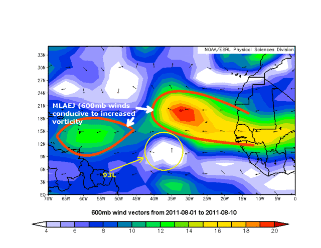
ozonepete wrote:This is just one factor, but an important one:
For easterly waves moving westward away from Africa, the MLAEJ (Mid-level African Easterly Jet) is an important factor in getting the wave to spin up. It is measured by 650 mb winds; the faster they are, the more vorticity at mid-levels which helps spin up an MLC. 93L has been in an area with almost no 600mb wind, but they will pick up markedly as the disturbance gets past 45-50 degrees west. (650mb is not a mandatory level so I used 600mb.)
0 likes
-
ozonepete
- Professional-Met

- Posts: 4743
- Joined: Mon Sep 07, 2009 3:23 pm
- Location: From Ozone Park, NYC / Now in Brooklyn, NY
Re: ATL : INVEST 93L - Discussion
wjs3 wrote: So, your forecast is for the invest to pick up mid level spin as it enters that more favorable MLAEJ area? Are you at all concerned about it staying on the cyclonic side of the jet?
No, because the strongest core of easterly winds should remain north of the COC, and the MLAEJ is more important in getting it started than keeping it going. And once the vortex spins up the MLAEJ should recede a little more north due to their interaction.
No, because the strongest core of easterly winds should remain north of the COC, and the MLAEJ is more important in getting it started than keeping it going. And once the vortex spins up the MLAEJ should recede a little more north due to their interaction.
0 likes
-
ozonepete
- Professional-Met
- Posts: 4743
- Joined: Mon Sep 07, 2009 3:23 pm
- Location: From Ozone Park, NYC / Now in Brooklyn, NY
Re: ATL : INVEST 93L - Discussion
cycloneye wrote:0%
SHOWER ACTIVITY ASSOCIATED WITH A BROAD LOW PRESSURE SYSTEM LOCATED
ABOUT 850 MILES WEST-SOUTHWEST OF THE SOUTHERN CAPE VERDE ISLANDS
HAS DIMINISHED. THIS SYSTEM HAS A LOW CHANCE...NEAR 0 PERCENT...
OF BECOMING A TROPICAL CYCLONE DURING THE NEXT 48 HOURS AS IT MOVES
WESTWARD AT 15 TO 20 MPH.
This makes sense. There is virtually no chance that this can get to TD status before Monday night or Tuesday morning. It's around that time that the conditions I mentioned, in addition to other factors, should be more conducive, as Gustywind's post of the NHC statement also shows.
0 likes
-
ozonepete
- Professional-Met
- Posts: 4743
- Joined: Mon Sep 07, 2009 3:23 pm
- Location: From Ozone Park, NYC / Now in Brooklyn, NY
Re: ATL : INVEST 93L - Discussion
[quote="'CaneFreak"]Good post. We need more of these types of posts on this board...someone is using their scientific brain...excellent!
[quote]
Thanks! I'm trying.
[quote]
Thanks! I'm trying.
0 likes
-
ConvergenceZone
.gif)
- Category 5
- Posts: 5241
- Joined: Fri Jul 29, 2005 1:40 am
- Location: Northern California
-
ozonepete
- Professional-Met
- Posts: 4743
- Joined: Mon Sep 07, 2009 3:23 pm
- Location: From Ozone Park, NYC / Now in Brooklyn, NY
Re:
ConvergenceZone wrote:Since it's now at 0 percent, I wonder if 93L will be soon be deactivated? I know we've seen that happen in the past.
Good question. I don't remember what they do if it goes to zero. Luis?
0 likes
-
cycloneye
- Admin
- Posts: 149431
- Age: 69
- Joined: Thu Oct 10, 2002 10:54 am
- Location: San Juan, Puerto Rico
Re: ATL : INVEST 93L - Discussion
Good question. I don't remember what they do if it goes to zero. Luis?
Deactivate is what they have done,but it has occured on some ocasions that the invest stays a bit longer.
0 likes
Visit the Caribbean-Central America Weather Thread where you can find at first post web cams,radars
and observations from Caribbean basin members Click Here
and observations from Caribbean basin members Click Here
-
WeatherLovingDoc

- S2K Supporter

- Posts: 453
- Joined: Fri Sep 05, 2008 10:08 pm
- Location: Washington D.C.
Re: ATL: INVEST 93L - Models
"underthwx ... it is the GFS which is the main American medium-range computer model. This model and the European are considered the two major medium-range computer models. "
All reasonable posts are welcomed here, underthwx. You did well in your question, as it taught me, and maybe others, what the main weather community medium-range computer models are. I didn't know what Portastorm mentioned, and your questioned helped enlighten me.
Many of us keep low profiles, and stumble repetitively over weather words. For example, no matter how many times I try to grasp the difference between "trough" and "ridge" I stumble. One day I think I get it, then realize I don't. I'm a visual thinker and will be happy when the day comes when I finally truly understand their difference.
Keep on posting, and welcome!
-WLD
0 likes

-
SouthDadeFish

- Professional-Met
- Posts: 2835
- Joined: Thu Sep 23, 2010 2:54 pm
- Location: Miami, FL
- Contact:
Re:
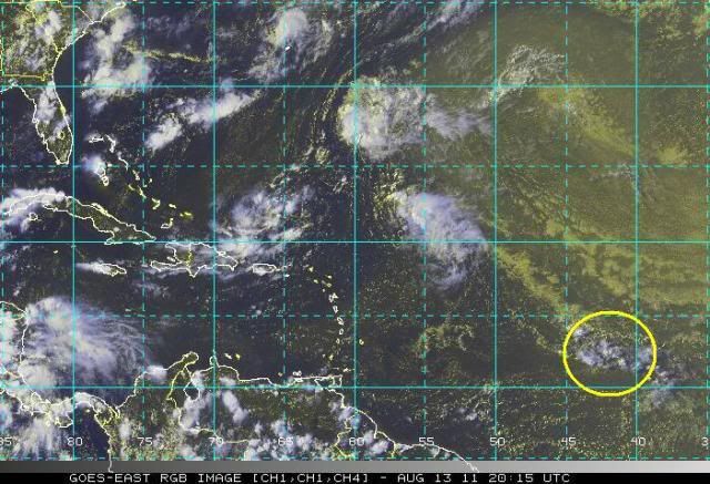
abajan wrote:Folks, don't be lulled into thinking this thing is dead. IMO it clearly isn't as convection is beginning to pickup. The TWOs just talk about the next 48 hours.
I couldn't agree more. In fact, it's worse for us who live in the Atlantic Basin that these waves are taking a while to get going. As a result, they are less likely to recurve.
0 likes
-
ozonepete
- Professional-Met
- Posts: 4743
- Joined: Mon Sep 07, 2009 3:23 pm
- Location: From Ozone Park, NYC / Now in Brooklyn, NY
Re:
abajan wrote:Folks, don't be lulled into thinking this thing is dead. IMO it clearly isn't as convection is beginning to pickup. The TWOs just talk about the next 48 hours.
I guess that's obvious from my posts that I don't think it's dead.
0 likes
-
Jevo

- S2K Supporter
- Posts: 1729
- Age: 47
- Joined: Tue Aug 03, 2004 8:45 pm
- Location: The Flemish Cap
- Contact:
SHOWER ACTIVITY ASSOCIATED WITH A BROAD LOW PRESSURE SYSTEM LOCATED
ABOUT 850 MILES WEST-SOUTHWEST OF THE SOUTHERN CAPE VERDE ISLANDS
HAS DIMINISHED. THIS SYSTEM HAS A LOW CHANCE...NEAR 0 PERCENT...
OF BECOMING A TROPICAL CYCLONE DURING THE NEXT 48 HOURS AS IT MOVES
WESTWARD AT 15 TO 20 MPH.

Last edited by Jevo on Sat Aug 13, 2011 8:59 pm, edited 1 time in total.
0 likes
Disclaimer: 50% of the time I have no clue of what I am talking about. Chances are I am taking a less than educated guess that sounds good because 10 years ago I stole Mike Watkins book 'The Hurricane and its Impact'. For official information please direct yourself to the NHC and their cadre of weather geniuses.
-
'CaneFreak
- Category 5
- Posts: 1487
- Joined: Mon Jun 05, 2006 10:50 am
- Location: New Bern, NC
-
Jevo
- S2K Supporter
- Posts: 1729
- Age: 47
- Joined: Tue Aug 03, 2004 8:45 pm
- Location: The Flemish Cap
- Contact:
Re: Re:
'CaneFreak wrote:NOPE...cause Wxman didn't say it...
 Jevo wrote:
lol so true
0 likes
Disclaimer: 50% of the time I have no clue of what I am talking about. Chances are I am taking a less than educated guess that sounds good because 10 years ago I stole Mike Watkins book 'The Hurricane and its Impact'. For official information please direct yourself to the NHC and their cadre of weather geniuses.
-
brunota2003

- S2K Supporter
- Posts: 9476
- Age: 35
- Joined: Sat Jul 30, 2005 9:56 pm
- Location: Stanton, KY...formerly Havelock, NC
- Contact:
-
Rainband
Re: ATL: INVEST 93L - Models
yall need the rain more. it's yoursROCK wrote:for you NOGAPS huggers...not sure what it is doing on the 18Z....
https://www.fnmoc.navy.mil/wxmap_cgi/cg ... t=Tropical
0 likes
Who is online
Users browsing this forum: No registered users and 10 guests