ATL: EMILY - Remnants
Moderator: S2k Moderators
-
Tampa_God

- Category 1

- Posts: 333
- Age: 35
- Joined: Wed May 31, 2006 7:27 pm
- Location: New Port Richey/Trinity, FL
Re: ATL: EMILY - Tropical Storm - Discussion
To me, it looks like the center has refocused itself a little to the southwest from the previous hours. Maybe I'm just the only one....
0 likes
-
Kory
- Tropical Storm

- Posts: 200
- Age: 30
- Joined: Tue Aug 02, 2011 11:32 am
- Location: New Orleans, Louisiana
Re: ATL: EMILY - Tropical Storm - Discussion
Ivanhater wrote:ConvergenceZone wrote:Let's face it, the conditions out in the Atlantic/Carib are just horrible for anything to get going at this time. So it's the same old story.
I think in the next 2 to 3 weeks the tropics will get rockin as the conditions vastly improve....
Please know what you are talking about before you post. What are the "horrible" conditions in the Caribbean right now. Conditions are actually really good and that is why this could be a hurricane. The issue has to do with the inner dynamics within the storm not allowing a solid center.
This is true, virtually no shear. Now as it heads up toward the Bahamas, the ridge over continental US may give the system a little north shear.
0 likes
-
StormClouds63
- Category 2

- Posts: 583
- Age: 62
- Joined: Tue May 13, 2008 11:56 am
- Location: Southwest Louisiana
Re: ATL: EMILY - Tropical Storm - Discussion
Cainer wrote:StormClouds63 wrote:In the event Emily does not attain hurricane status, that would make 5/5 named systems to start the season ... all w/o reaching hurricane strength. Does anyone know if that has happened before to start an Atlantic tropical season? Just wondering.
Happened in 2002 - first 6 named storms failed to become hurricanes.
Thanks for the info.
0 likes
-
cycloneye

- Admin

- Posts: 148985
- Age: 69
- Joined: Thu Oct 10, 2002 10:54 am
- Location: San Juan, Puerto Rico
Re:
mf_dolphin wrote:If it does here's a good pretty topo map of Hispaniola.
Fairly high mountains to welcome her on the current NHC track
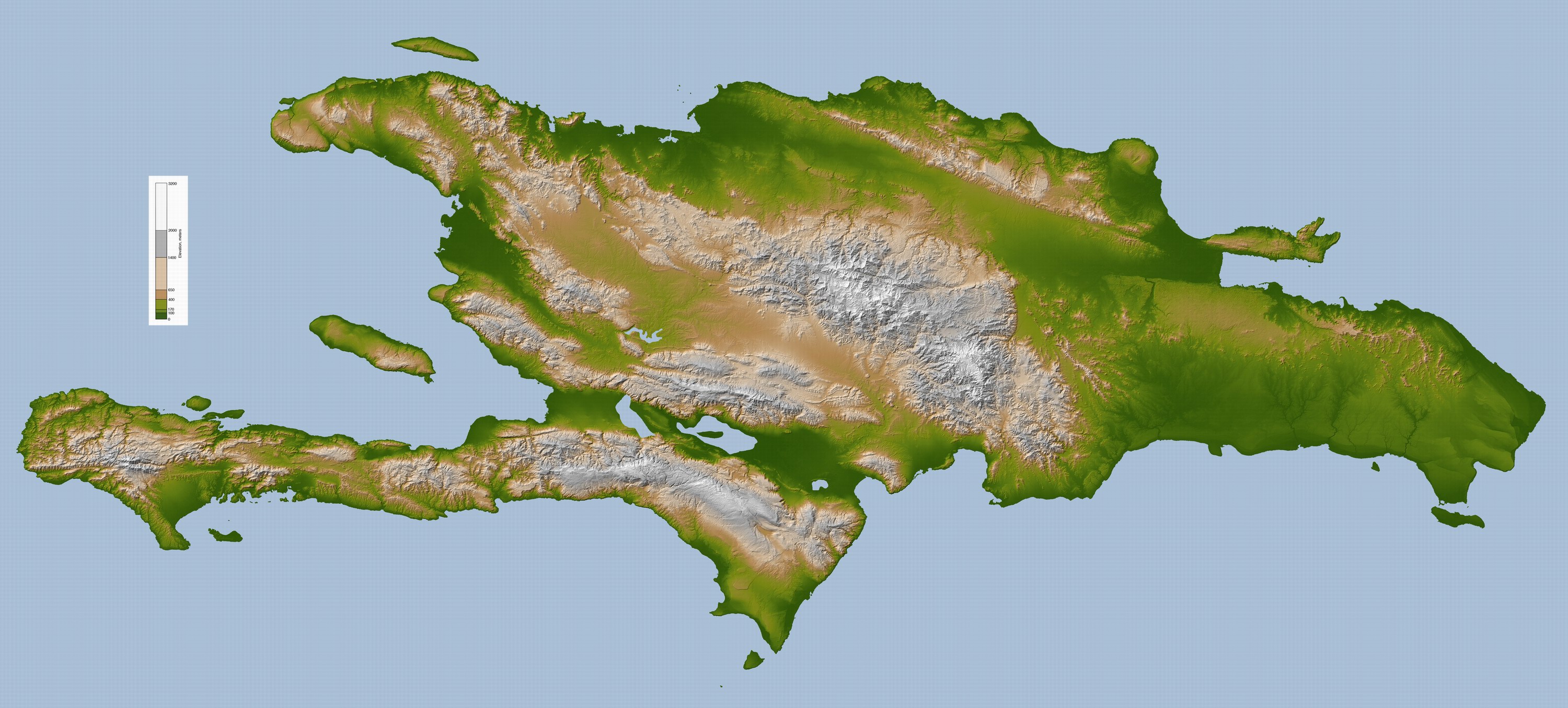
It may avoid the tallest ones in DR if it tracks thru the Haiti Penninsula.
0 likes
Visit the Caribbean-Central America Weather Thread where you can find at first post web cams,radars
and observations from Caribbean basin members Click Here
and observations from Caribbean basin members Click Here
-
Bocadude85

- Category 5

- Posts: 2991
- Age: 39
- Joined: Mon Apr 18, 2005 2:20 pm
- Location: Honolulu,Hi
Re: ATL: EMILY - Models
I think we are going to see another shift east at the 5pm update.. the NWS Miami has taken "tropical storm conditions possible" out of the forecast for my area.
0 likes
-
mf_dolphin

- Category 5
- Posts: 17758
- Age: 69
- Joined: Tue Oct 08, 2002 2:05 pm
- Location: St Petersburg, FL
- Contact:
-
Kory
- Tropical Storm
- Posts: 200
- Age: 30
- Joined: Tue Aug 02, 2011 11:32 am
- Location: New Orleans, Louisiana
Re: ATL: EMILY - Tropical Storm - Discussion
Its amazing how good she looks on satelitte, but truly she is disorganized.
0 likes
-
ConvergenceZone
.gif)
- Category 5
- Posts: 5241
- Joined: Fri Jul 29, 2005 1:40 am
- Location: Northern California
Re: ATL: EMILY - Tropical Storm - Discussion
Ivanhater wrote:ConvergenceZone wrote:Let's face it, the conditions out in the Atlantic/Carib are just horrible for anything to get going at this time. So it's the same old story.
I think in the next 2 to 3 weeks the tropics will get rockin as the conditions vastly improve....
Please know what you are talking about before you post. What are the "horrible" conditions in the Caribbean right now. Conditions are actually really good and that is why this could be a hurricane. The issue has to do with the inner dynamics within the storm not allowing a solid center.
Actually all one has to do is look at why Emily hasn't developed. Dry Air/Northerly Shear.
The blanket statement regarding conditions in the Atlantic was also referring to all of the SAL which should subside, but there's still ALOT of dry air out there....
Remember Ivanhater, when the conditions are good for systems to get going, the systems will be the first to tell you, because they won't struggle like they've been doing as of late, which really is pretty common for this time of year.
Let me ask you then, what makes the conditions really good for Emily that you are seeing? Please elaborate....
0 likes
-
dolebot_Broward_NW
- Category 2
- Posts: 529
- Joined: Fri Sep 10, 2004 6:38 am
Re:
mf_dolphin wrote:If it does here's a good pretty topo map of Hispaniola.
http://upload.wikimedia.org/wikipedia/c ... la_lrg.jpg
Fairly high mountains to welcome her on the current NHC track
That reminds me, I meant to ask if anyone knew if the models (global and otherwise) take into account the topology of the region. Do they inherently know that Hispaniola is fairly mountainous? Or that the tip of the Yucatan is flat like a lake? Or that SW Florida is more water than land in the summer?
0 likes
-
mf_dolphin
- Category 5
- Posts: 17758
- Age: 69
- Joined: Tue Oct 08, 2002 2:05 pm
- Location: St Petersburg, FL
- Contact:
-
HurricaneWarning92
- Category 2
- Posts: 520
- Joined: Sat Jul 23, 2011 4:33 pm
- Location: Pembroke Pines, S. Florida (Lat: 26.00N, Lon: 80.22W)
Re: Re:
jlauderdal wrote:HurricaneWarning92 wrote:Wow i really hope future systems dont struggle as much as this one. At first we can say it was rather interesting but now it just irritates you and gives you a head ache.
would you rather have clean systems heading towards west broward?
what do you mean by that? Cat. 5?
0 likes
The posts in this forum are NOT official forecast and should not be used as such. They are just the opinion of the poster and may or may not be backed by sound meteorological data. They are NOT endorsed by any professional institution or storm2k.org. For official information, please refer to the NHC and NWS products.

i just looked at vapor and it looks like the llc is dead on to nhc forecast. its headed toward its next forecast point.
Last edited by robbielyn on Tue Aug 02, 2011 3:42 pm, edited 1 time in total.
0 likes
Robbielyn McCrary
I know just about enough to sound like I know what I'm talking about sometimes. But for your safety please follow the nhc for truly professional forecasting.
I know just about enough to sound like I know what I'm talking about sometimes. But for your safety please follow the nhc for truly professional forecasting.
-
Evil Jeremy

- S2K Supporter

- Posts: 5463
- Age: 32
- Joined: Mon Apr 10, 2006 2:10 pm
- Location: Los Angeles, CA
-
cycloneye
- Admin
- Posts: 148985
- Age: 69
- Joined: Thu Oct 10, 2002 10:54 am
- Location: San Juan, Puerto Rico
Re: ATL: EMILY - Tropical Storm - Discussion
From 5 PM advisory.
THE GOVERNMENT OF THE BAHAMAS HAS ISSUED A TROPICAL STORM WATCH FOR
THE SOUTHEAST BAHAMAS AND FOR THE TURKS AND CAICOS ISLANDS.
THE GOVERNMENT OF THE BAHAMAS HAS ISSUED A TROPICAL STORM WATCH FOR
THE SOUTHEAST BAHAMAS AND FOR THE TURKS AND CAICOS ISLANDS.
0 likes
Visit the Caribbean-Central America Weather Thread where you can find at first post web cams,radars
and observations from Caribbean basin members Click Here
and observations from Caribbean basin members Click Here
-
Kory
- Tropical Storm
- Posts: 200
- Age: 30
- Joined: Tue Aug 02, 2011 11:32 am
- Location: New Orleans, Louisiana
Re: ATL: EMILY - Tropical Storm - Discussion
ConvergenceZone wrote:Ivanhater wrote:ConvergenceZone wrote:Let's face it, the conditions out in the Atlantic/Carib are just horrible for anything to get going at this time. So it's the same old story.
I think in the next 2 to 3 weeks the tropics will get rockin as the conditions vastly improve....
Please know what you are talking about before you post. What are the "horrible" conditions in the Caribbean right now. Conditions are actually really good and that is why this could be a hurricane. The issue has to do with the inner dynamics within the storm not allowing a solid center.
Actually all one has to do is look at why Emily hasn't developed. Dry Air/Northerly Shear.
The blanket statement regarding conditions in the Atlantic was also referring to all of the SAL which should subside, but there's still ALOT of dry air out there....
Remember Ivanhater, when the conditions are good for systems to get going, the systems will be the first to tell you, because they won't struggle like they've been doing as of late, which really is pretty common for this time of year.
Let me ask you then, what makes the conditions really good for Emily that you are seeing? Please elaborate....
The Eastern Caribbean is always a turbulent place for tropical systems, but it doesn't have that much north shear as you can clearly see the outflow. Now, Emily may encounter more shear from the ridge as she heads toward the Bahamas.
0 likes
-
AdamFirst

- S2K Supporter
- Posts: 2490
- Age: 36
- Joined: Thu Aug 14, 2008 10:54 am
- Location: Port Saint Lucie, FL
Re: ATL: EMILY - Tropical Storm - Discussion
BULLETIN
TROPICAL STORM EMILY ADVISORY NUMBER 5
NWS NATIONAL HURRICANE CENTER MIAMI FL AL052011
500 PM AST TUE AUG 02 2011
...EMILY A LITTLE STRONGER...BUT STILL NOT WELL ORGANIZED...
SUMMARY OF 500 PM AST...2100 UTC...INFORMATION
----------------------------------------------
LOCATION...15.8N 65.4W
ABOUT 185 MI...300 KM SSE OF SAN JUAN PUERTO RICO
MAXIMUM SUSTAINED WINDS...50 MPH...85 KM/H
PRESENT MOVEMENT...WNW OR 295 DEGREES AT 12 MPH...19 KM/H
MINIMUM CENTRAL PRESSURE...1005 MB...29.68 INCHES
0 likes
Dolphins Marlins Canes Golden Panthers HEAT
Andrew 1992 - Irene 1999 - Frances 2004 - Jeanne 2004 - Wilma 2005 - Fay 2008 - Isaac 2012 - Matthew 2016 - Irma 2017 - Dorian 2019 - Ian 2022 - Nicole 2022 - Milton 2024
Andrew 1992 - Irene 1999 - Frances 2004 - Jeanne 2004 - Wilma 2005 - Fay 2008 - Isaac 2012 - Matthew 2016 - Irma 2017 - Dorian 2019 - Ian 2022 - Nicole 2022 - Milton 2024
-
cycloneye
- Admin
- Posts: 148985
- Age: 69
- Joined: Thu Oct 10, 2002 10:54 am
- Location: San Juan, Puerto Rico
Re: ATL: EMILY - Advisories
BULLETIN
TROPICAL STORM EMILY ADVISORY NUMBER 5
NWS NATIONAL HURRICANE CENTER MIAMI FL AL052011
500 PM AST TUE AUG 02 2011
...EMILY A LITTLE STRONGER...BUT STILL NOT WELL ORGANIZED...
SUMMARY OF 500 PM AST...2100 UTC...INFORMATION
----------------------------------------------
LOCATION...15.8N 65.4W
ABOUT 185 MI...300 KM SSE OF SAN JUAN PUERTO RICO
MAXIMUM SUSTAINED WINDS...50 MPH...85 KM/H
PRESENT MOVEMENT...WNW OR 295 DEGREES AT 12 MPH...19 KM/H
MINIMUM CENTRAL PRESSURE...1005 MB...29.68 INCHES
WATCHES AND WARNINGS
--------------------
CHANGES WITH THIS ADVISORY...
THE GOVERNMENT OF THE BAHAMAS HAS ISSUED A TROPICAL STORM WATCH FOR
THE SOUTHEAST BAHAMAS AND FOR THE TURKS AND CAICOS ISLANDS.
SUMMARY OF WATCHES AND WARNINGS IN EFFECT...
A TROPICAL STORM WARNING IS IN EFFECT FOR...
* PUERTO RICO...VIEQUES AND CULEBRA
* THE DOMINICAN REPUBLIC
* HAITI
A TROPICAL STORM WATCH IS IN EFFECT FOR...
* U.S. VIRGIN ISLANDS
* SOUTHEAST BAHAMAS AND TURKS AND CAICOS ISLANDS
FOR STORM INFORMATION SPECIFIC TO YOUR AREA IN THE UNITED
STATES...INCLUDING POSSIBLE INLAND WATCHES AND WARNINGS...PLEASE
MONITOR PRODUCTS ISSUED BY YOUR LOCAL NATIONAL WEATHER SERVICE
FORECAST OFFICE. FOR STORM INFORMATION SPECIFIC TO YOUR AREA OUTSIDE
THE UNITED STATES...PLEASE MONITOR PRODUCTS ISSUED BY YOUR NATIONAL
METEOROLOGICAL SERVICE.
DISCUSSION AND 48-HOUR OUTLOOK
------------------------------
AT 500 PM AST...2100 UTC...THE CENTER OF TROPICAL STORM EMILY WAS
ESTIMATED TO BE NEAR LATITUDE 15.8 NORTH...LONGITUDE 65.4 WEST.
EMILY IS MOVING TOWARD THE WEST-NORTHWEST NEAR 12 MPH...19 KM/H...
AND THIS GENERAL MOTION WITH A GRADUAL TURN TO THE NORTHWEST IS
EXPECTED DURING THE NEXT 24 TO 48 HOURS. THE FORECAST TRACK BRINGS
THE CENTER OF EMILY ACROSS HISPANIOLA LATE WEDNESDAY AND INTO THE
SOUTHEASTERN BAHAMAS ON THURSDAY.
MAXIMUM SUSTAINED WINDS HAVE INCREASED TO NEAR 50 MPH...85 KM/H...
WITH HIGHER GUSTS. THESE STRONG WINDS ARE LOCATED MAINLY TO THE
NORTH AND EAST OF THE CENTER. SOME SLIGHT STRENGTHENING IS POSSIBLE
BEFORE THE CENTER MOVES OVER THE HIGH TERRAIN OF HISPANIOLA.
TROPICAL STORM FORCE WINDS EXTEND OUTWARD UP TO 105 MILES...165 KM
MAINLY TO THE NORTH AND EAST OF THE CENTER.
ESTIMATED MINIMUM CENTRAL PRESSURE IS 1005 MB...29.68 INCHES.
HAZARDS AFFECTING LAND
----------------------
WIND...TROPICAL STORM CONDITIONS ARE EXPECTED IN PUERTO RICO...
CULEBRA...AND VIEQUES TONIGHT...AND SHOULD BEGIN TO SPREAD IN THE
DOMINICAN REPUBLIC AND HAITI ON WEDNESDAY. TROPICAL STORM
CONDITIONS ARE POSSIBLE IN THE U.S. VIRGIN ISLANDS TONIGHT.
RAINFALL...EMILY IS EXPECTED TO PRODUCE TOTAL RAIN ACCUMULATIONS
OF 4 TO 6 INCHES IN PUERTO RICO...THE DOMINICAN REPUBLIC...AND HAITI
WITH ISOLATED MAXIMUM AMOUNTS OF 10 INCHES POSSIBLE. THESE RAINS
COULD CAUSE LIFE-THREATENING FLASH FLOODS AND MUD SLIDES IN AREAS
OF MOUNTAINOUS TERRAIN.
STORM SURGE...A STORM SURGE WILL RAISE WATER LEVELS BY 1 TO 2 FEET
ABOVE NORMAL TIDE LEVELS IN THE TROPICAL STORM WARNING AREA. NEAR
THE COAST...THE SURGE WILL BE ACCOMPANIED BY LARGE AND DANGEROUS
WAVES.
NEXT ADVISORY
-------------
NEXT INTERMEDIATE ADVISORY...800 PM AST.
NEXT COMPLETE ADVISORY...1100 PM AST.
$$
FORECASTER AVILA
TROPICAL STORM EMILY DISCUSSION NUMBER 5
NWS NATIONAL HURRICANE CENTER MIAMI FL AL052011
500 PM AST TUE AUG 02 2011
THERE HAS BEEN A SLIGHT INCREASE IN THE ORGANIZATION OF THE CLOUD
PATTERN ASSOCIATED WITH EMILY...AND SATELLITE INTENSITY ESTIMATES
REMAIN 3.0 ON THE DVORAK SCALE. THERE HAS ALSO BEEN SOME INCREASE
IN THE WINDS IN THE NORTHERN SEMICIRCLE...BUT DATA FROM THE AIR
FORCE RECONNAISSANCE PLANE INDICATE THAT THE CIRCULATION IS NOT YET
WELL DEFINED AND PRESSURES HAVE NOT FALLEN SIGNIFICANTLY SINCE
YESTERDAY. THE INITIAL INTENSITY HAS BEEN SET AT 45 KNOTS AND
CONDITIONS APPEAR FAVORABLE FOR SLIGHT STRENGTHENING BEFORE
EMILY MOVES OVER HISPANIOLA IN ABOUT 24 TO 36 HOURS. IF EMILY
SURVIVES THE HIGH TERRAIN...THE UPPER-LEVEL ENVIRONMENT IS FORECAST
TO BE MORE CONDUCIVE FOR SOME RE-INTENSIFICATION ONCE THE CYCLONE
MOVES OVER THE SOUTHEAST OR CENTRAL BAHAMAS. THE GFS...WHICH
DISSIPATED EMILY IN THE TWO PREVIOUS RUNS HAS A SIGNIFICANT TROPICAL
STORM MOVING EASTERN HISPANIOLA AND THE BAHAMAS IN THE 12 UTC RUN.
THE ECMWF CONTINUES TO DISSIPATE THE CYCLONE.
SINCE THE CENTER HAS BEEN DIFFICULT TO LOCATE AND HAS BEEN REFORMING
DURING THE PAST SEVERAL HOURS...THE INITIAL MOTION IS HIGHLY
UNCERTAIN. IT APPEARS THAT EMILY HAS RESUMED A WESTWARD TRACK AND
IS NOW MOVING ABOUT 280 DEGREES AT 12 KNOTS. MOST OF THE GLOBAL
MODELS CONTINUE TO SHOW THE DEVELOPMENT OF A LARGE MID-LEVEL TROUGH
OVER THE WESTERN ATLANTIC WITH THE SUBTROPICAL RIDGE SHIFTING
EASTWARD. THIS STEERING PATTERN CALLS FOR A GRADUAL TURN TO
NORTHWEST AND NORTH DURING THE NEXT SEVERAL DAYS WITH NO SIGNIFICANT
CHANGE IN SPEED. MOST OF THE LATEST TRACK GUIDANCE IS CONSISTENT
WITH THE OFFICIAL FORECAST...WHICH SHOWS EMILY MOVING NORTHWARD
ACROSS THE BAHAMAS WELL OFFSHORE OF THE UNITED STATES EAST COAST.
FORECAST POSITIONS AND MAX WINDS
INIT 02/2100Z 15.8N 65.4W 45 KT 50 MPH
12H 03/0600Z 16.2N 66.9W 45 KT 50 MPH
24H 03/1800Z 17.3N 68.7W 50 KT 60 MPH
36H 04/0600Z 18.5N 70.5W 35 KT 40 MPH...INLAND
48H 04/1800Z 20.5N 72.5W 30 KT 35 MPH...OVER WATER
72H 05/1800Z 24.0N 76.0W 40 KT 45 MPH
96H 06/1800Z 28.0N 78.0W 50 KT 60 MPH
120H 07/1800Z 32.0N 77.0W 60 KT 70 MPH
$$
FORECASTER AVILA
0 likes
Visit the Caribbean-Central America Weather Thread where you can find at first post web cams,radars
and observations from Caribbean basin members Click Here
and observations from Caribbean basin members Click Here
-
SouthDadeFish

- Professional-Met

- Posts: 2835
- Joined: Thu Sep 23, 2010 2:54 pm
- Location: Miami, FL
- Contact:
-
Evil Jeremy
- S2K Supporter
- Posts: 5463
- Age: 32
- Joined: Mon Apr 10, 2006 2:10 pm
- Location: Los Angeles, CA
Re: ATL: EMILY - Tropical Storm - Discussion
AdamFirst wrote:WNW OR 295 DEGREES AT 12 MPH
That's interesting, because in the Discussion Avila says this:
IT APPEARS THAT EMILY HAS RESUMED A WESTWARD TRACK AND
IS NOW MOVING ABOUT 280 DEGREES AT 12 KNOTS
SouthDadeFish wrote:The discussion says Emily is moving at 280 degrees but the public advisory says 295 lol...
Ya beat me to it lol.
Anyways, I think the NHC is expecting Emily to start moving NW too quickly. Looking at their cone Emily needs to start moving a little more north than 280 degrees soon... or 295.... perhaps over 9000...
Last edited by Evil Jeremy on Tue Aug 02, 2011 3:50 pm, edited 1 time in total.
0 likes
Frances 04 / Jeanne 04 / Katrina 05 / Wilma 05 / Fay 08 / Debby 12 / Andrea 13 / Colin 16 / Hermine 16 / Matthew 16 / Irma 17
-
Bocadude85
- Category 5
- Posts: 2991
- Age: 39
- Joined: Mon Apr 18, 2005 2:20 pm
- Location: Honolulu,Hi
Re: ATL: EMILY - Tropical Storm - Discussion
Evil Jeremy wrote:AdamFirst wrote:WNW OR 295 DEGREES AT 12 MPH
That's interesting, because in the Discussion Avila says this:
IT APPEARS THAT EMILY HAS RESUMED A WESTWARD TRACK AND
IS NOW MOVING ABOUT 280 DEGREES AT 12 KNOTS
I was just about to point that out.. also the the point of closest approach to S. Fla realyl hasnt changed much since the 11pm advosory... about a 100 miles or so off the coast
Last edited by Bocadude85 on Tue Aug 02, 2011 3:51 pm, edited 1 time in total.
0 likes
Who is online
Users browsing this forum: No registered users and 15 guests