Here is the prognostic reasoning of the 00:00z warning by JTWC.
WDPN31 PGTW 250300
MSGID/GENADMIN/NAVMARFCSTCEN PEARL HARBOR HI/JTWC//
SUBJ/PROGNOSTIC REASONING FOR TYPHOON 04W WARNING NR 20//
RMKS/
1. FOR METEOROLOGISTS.
2. 12 HOUR SUMMARY AND ANALYSIS.
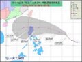
A. TYPHOON (TY) 04W (SONGDA), LOCATED APPROXIMATELY 430 NM
EAST-SOUTHEAST OF MANILA, PHILIPPINES, HAS TRACKED WEST-
NORTHWESTWARD AT 05 KNOTS OVER THE PAST SIX HOURS. ANIMATED
MULTISPECTRAL SATELLITE IMAGERY DEPICTS A RAPIDLY CONSOLIDATING LOW-
LEVEL CIRCULATION CENTER (LLCC) WITH A 10 NM RAGGED EYE. TY 04W HAS
RAPIDLY INTENSIFIED OVER THE PAST 24 HOURS, INCREASING INTENSITY
FROM 60 KNOTS TO THE CURRENT INTENSITY OF 90 KNOTS. A 242316Z SSMIS
IMAGE ALSO INDICATES IMPROVED ORGANIZATION WITH AN OBLONG EYEWALL
AND MULTIPLE CONVECTIVE BANDING WRAPPING INTO THE CENTER. THERE IS
GOOD CONFIDENCE IN THE CURRENT POSITION AND RECENT MOTION. TY 04W
HAS SLOWED AND BEGUN TO TRACK MORE POLEWARD. THE CURRENT INTENSITY
IS BASED ON DVORAK ESTIMATES OF 90 KNBOTS FROM BOTH KNES AND PGTW.
3. FORECAST REASONING.
A. NO CHANGE IN FORECAST PHILOSOPHY.
B. TY 04W IS TRACKING WEST-NORTHWESTWARD ALONG THE SOUTHWEST
PERIPHERY OF THE MID-LEVEL SUBTROPICAL STEERING RIDGE (STR)
POSITIONED SOUTH OF JAPAN. THE 24/12Z 500MB ANALYSIS INDICATES
PERSISTENT WESTERLY FLOW OVER CHINA, EAST CHINA SEA AND SOUTH CHINA
SEA ASSOCIATED WITH A BROAD LONGWAVE TROUGH. CONSEQUENTLY, THE
WESTERN BRANCH OF THE STR HAS SHIFTED WEST INTO SOUTHEAST ASIA AND
WEAKENED. BASED ON THIS SYNOPTIC PATTERN, THERE IS HIGH CONFIDENCE
THAT TY 04W WILL TURN POLEWARD WITHIN THE NEXT 24 HOURS AND TRACK
EAST OF LUZON AND TAIWAN. WITH THE EXCEPTION OF THE UKMO TRACKER,
MODEL GUIDANCE IS IN TIGHT AGREEMENT THROUGH TAU 72 THEREFORE THIS
FORECAST IS POSITIONED CLOSE TO THE MODEL CONSENSUS. TY 04W SHOULD
CONTINUE TO INTENSIFY DUE TO FAVORABLE UPPER-LEVEL OUTFLOW AND
SHOULD PEAK AT 115 KNOTS WITHIN THE NEXT 48-60 HOURS. AFTER TAU 60,
THE SYSTEM WILL BEGIN TO ENCOUNTER INCREASING VERTICAL WIND SHEAR
(VWS) ASSOCIATED WITH AN APPROACHING SHORT-WAVE TROUGH AND SHOULD
WEAKEN SLIGHTLY BY TAU 72.
C. IN THE EXTENDED TAUS, MODEL GUIDANCE IS TIGHTLY-CLUSTERED FROM
A CROSS-TRACK PERSPECTIVE WITH THE EXCEPTION OF THE UKMO MODEL. THE
UKMO MODEL IS HIGHLY SUSPECT DUE TO THE POORLY INITIALIZED AND
FORECASTED INTENSITIES THROUGHOUT THE PERIOD. THE REMAINDER OF THE
MODEL GUIDANCE SUPPORTS A TRACK NEAR OKINAWA THEN SHARPLY RE-CURVING
SOUTH OF HONSHU AHEAD OF A DEEP MIDLATITUDE SHORT-WAVE TROUGH
FORECAST TO DIG INTO WESTERN JAPAN NEAR TAU 72. MODEL GUIDANCE,
HOWEVER, VARIES SIGNIFICANTLY FROM AN ALONG-TRACK PERSPECTIVE WITH
NOGAPS, GFDN AND GFS EAST OF HONSHU BY TAU 120. THE JGSM AND ECMWF
TRACKERS ARE QUITE A BIT SLOWER AND INDICATE A TAU 120 POSITION NEAR
KYUSHU. THIS FORECAST IS POSITIONED CLOSE TO THE CONSENSUS AT TAU 96
BUT SLIGHTLY FASTER AND EQUATORWARD AT TAU 120 AS IT BECOMES
EMBEDDED IN STRONG MIDLATITUDE WESTERLIES. TY 04W IS EXPECTED TO
WEAKEN RAPIDLY NEAR OKINAWA DUE TO INCREASING VWS AND COOLER SST.
THE SYSTEM IS EXPECTED TO COMPLETE EXTRA-TROPICAL TRANSITION NEAR
THE KANTO PLAIN BUT SHOULD REMAIN A STRONG 50-55 KNOT MIDLATITUDE
LOW.//
NNNN
WPAC: SONGDA - Tropical Depression (1102/04W)
Moderator: S2k Moderators
-
cycloneye

- Admin

- Posts: 149429
- Age: 69
- Joined: Thu Oct 10, 2002 10:54 am
- Location: San Juan, Puerto Rico
Re: WPAC: SONGDA - Typhoon (1102/04W)
0 likes
Visit the Caribbean-Central America Weather Thread where you can find at first post web cams,radars
and observations from Caribbean basin members Click Here
and observations from Caribbean basin members Click Here

-
oaba09
- S2K Supporter

- Posts: 1496
- Age: 39
- Joined: Thu Oct 01, 2009 10:02 am
- Location: Valenzuela, Philippines
- Contact:

TY 1102 (Songda)
Issued at 03:40 UTC, 25 May 2011
<Analyses at 25/03 UTC>
Scale -
Intensity Strong
Center position N12°30'(12.5°)
E128°05'(128.1°)
Direction and speed of movement W Slowly
Central pressure 960hPa
Maximum wind speed near the center 40m/s(75kt)
Maximum wind gust speed 55m/s(105kt)
Area of 50kt winds or more Wide 130km(70NM)
Area of 30kt winds or more NE330km(180NM)
SW260km(140NM)
<Forecast for 26/03 UTC>
Intensity Strong
Center position of probability circle N14°20'(14.3°)
E126°05'(126.1°)
Direction and speed of movement NW 10km/h(6kt)
Central pressure 950hPa
Maximum wind speed near the center 40m/s(80kt)
Maximum wind gust speed 60m/s(115kt)
Radius of probability circle 130km(70NM)
Storm warning area Wide 280km(150NM)
<Forecast for 27/00 UTC>
Intensity Strong
Center position of probability circle N16°50'(16.8°)
E124°25'(124.4°)
Direction and speed of movement NNW 15km/h(8kt)
Central pressure 945hPa
Maximum wind speed near the center 40m/s(80kt)
Maximum wind gust speed 60m/s(115kt)
Radius of probability circle 200km(110NM)
Storm warning area Wide 350km(190NM)
<Forecast for 28/00 UTC>
Intensity Strong
Center position of probability circle N20°30'(20.5°)
E123°05'(123.1°)
Direction and speed of movement NNW 20km/h(10kt)
Central pressure 945hPa
Maximum wind speed near the center 40m/s(80kt)
Maximum wind gust speed 60m/s(115kt)
Radius of probability circle 300km(160NM)
Storm warning area Wide 440km(240NM)
0 likes


Re: WPAC: SONGDA - Typhoon (1102/04W)
WTPQ20 RJTD 250300
RSMC TROPICAL CYCLONE ADVISORY
NAME TY 1102 SONGDA (1102)
ANALYSIS
PSTN 250300UTC 12.5N 128.1E FAIR
MOVE W SLOWLY
PRES 960HPA
MXWD 075KT
GUST 105KT
50KT 70NM
30KT 180NM NORTHEAST 140NM SOUTHWEST
FORECAST
24HF 260300UTC 14.3N 126.1E 70NM 70%
MOVE NW 06KT
PRES 950HPA
MXWD 080KT
GUST 115KT
45HF 270000UTC 16.8N 124.4E 110NM 70%
MOVE NNW 08KT
PRES 945HPA
MXWD 080KT
GUST 115KT
69HF 280000UTC 20.5N 123.1E 160NM 70%
MOVE NNW 10KT
PRES 945HPA
MXWD 080KT
GUST 115KT =
0 likes
-
Typhoon Hunter
- WesternPacificWeather.com

- Posts: 1222
- Joined: Wed Oct 11, 2006 11:37 am
- Location: Tokyo
- Contact:
Re: WPAC: SONGDA - Typhoon (1102/04W)
Really starting to get its act together now:
TPPN10 PGTW 250611
A. TYPHOON 04W (SONGDA)
B. 25/0532Z
C. 12.7N
D. 127.8E
E. ONE/MTSAT
F. T6.0/6.0/D2.5/24HRS STT: D1.0/06HRS
G. IR/EIR/VIS/MSI
H. REMARKS: 03A/PBO EYE/ANMTN. A 13NM BLK EYE IS SURROUNDED BY A
35NM WIDE CMG RING YIELDING AN EYE NUMBER OF 6.5. SUBTRACTED .5
FOR AN EYE ADJUSTMENT YIELDING A DT OF 6.0. FT BASED ON DT. PT
AGREES HOWEVER MET YIELDS 5.0 DUE THE SYSTEM ONLY BEING 3.5
24HRS AGO.
I. ADDITIONAL POSITIONS:
25/0114Z 12.4N 128.4E MMHS
KIENZLE
0 likes
-
phwxenthusiast
- Category 2

- Posts: 637
- Joined: Wed Mar 24, 2010 3:10 am
- Location: Holbrook, NY (Long Island)
-
oaba09
- S2K Supporter
- Posts: 1496
- Age: 39
- Joined: Thu Oct 01, 2009 10:02 am
- Location: Valenzuela, Philippines
- Contact:
TY 1102 (Songda)
Issued at 06:50 UTC, 25 May 2011
<Analyses at 25/06 UTC>
Scale -
Intensity Very Strong
Center position N12°35'(12.6°)
E127°50'(127.8°)
Direction and speed of movement W Slowly
Central pressure 945hPa
Maximum wind speed near the center 45m/s(90kt)
Maximum wind gust speed 65m/s(130kt)
Area of 50kt winds or more Wide 170km(90NM)
Area of 30kt winds or more NE370km(200NM)
SW300km(160NM)
<Forecast for 26/06 UTC>
Intensity Very Strong
Center position of probability circle N14°50'(14.8°)
E126°00'(126.0°)
Direction and speed of movement NW 15km/h(7kt)
Central pressure 940hPa
Maximum wind speed near the center 45m/s(90kt)
Maximum wind gust speed 65m/s(130kt)
Radius of probability circle 130km(70NM)
Storm warning area Wide 300km(160NM)
<Forecast for 27/06 UTC>
Intensity Very Strong
Center position of probability circle N17°55'(17.9°)
E124°05'(124.1°)
Direction and speed of movement NNW 15km/h(8kt)
Central pressure 935hPa
Maximum wind speed near the center 50m/s(95kt)
Maximum wind gust speed 70m/s(135kt)
Radius of probability circle 200km(110NM)
Storm warning area Wide 390km(210NM)
<Forecast for 28/06 UTC>
Intensity Very Strong
Center position of probability circle N21°10'(21.2°)
E123°50'(123.8°)
Direction and speed of movement N 15km/h(8kt)
Central pressure 935hPa
Maximum wind speed near the center 50m/s(95kt)
Maximum wind gust speed 70m/s(135kt)
Radius of probability circle 300km(160NM)
Storm warning area Wide 480km(260NM)
0 likes
-
Typhoon Hunter
- WesternPacificWeather.com
- Posts: 1222
- Joined: Wed Oct 11, 2006 11:37 am
- Location: Tokyo
- Contact:
Re: WPAC: SONGDA - Typhoon (1102/04W)
Looks like a textbook pinhole eye on CWB vis satellite 1500 frame:
http://www.cwb.gov.tw/eng/observe/satellite/Sat_H_EA.htm?type=RGB
http://www.cwb.gov.tw/eng/observe/satellite/Sat_H_EA.htm?type=RGB
0 likes
-
StormingB81

- S2K Supporter
- Posts: 5676
- Age: 44
- Joined: Thu Aug 27, 2009 1:45 am
- Location: Rockledge, Florida
-
Typhoon Hunter
- WesternPacificWeather.com
- Posts: 1222
- Joined: Wed Oct 11, 2006 11:37 am
- Location: Tokyo
- Contact:
Re:
StormingB81 wrote:As stated earlier..Okinawa is now in TCCOR 4.
Many thanks for stating again then
Impressive RI over last 12 hours and JTWC now forecasting peak of 125kts.
0 likes
-
StormingB81
- S2K Supporter
- Posts: 5676
- Age: 44
- Joined: Thu Aug 27, 2009 1:45 am
- Location: Rockledge, Florida
-
Typhoon Hunter
- WesternPacificWeather.com
- Posts: 1222
- Joined: Wed Oct 11, 2006 11:37 am
- Location: Tokyo
- Contact:
Re:
StormingB81 wrote:If the JTWC track and everything stays the same Okinawa looks like it will get a Cat 3 Typhoon of like 120mph winds gusting to 150...that is intense...I know they say these buildings can with stand that force..but man I just paid off my car last week..gotta find a place for it
Can I borrow it then?
In all seriousness we still have a good few days to go before we know specifically how bad it might be in Okinawa but it might be a good idea to look for a safe spot for the car. The buildings will be absolutely fine though. The big cone of uncertainty is there for a reason!
0 likes
-
climateconcern23
- Tropical Low

- Posts: 35
- Age: 35
- Joined: Sat Mar 05, 2011 4:38 am
- Location: Philippines
- Contact:
Re: WPAC: SONGDA - Severe Tropical Storm (1102/04W)
ClarkEligue wrote:climateconcern23 wrote:If Songda continues its direction then BICOL is in grave of danger.
Where in the beautiful country of ours are you at, man?
Parañaque c:
0 likes
Re:
StormingB81 wrote:If the JTWC track and everything stays the same Okinawa looks like it will get a Cat 3 Typhoon of like 120mph winds gusting to 150...that is intense...I know they say these buildings can with stand that force..but man I just paid off my car last week..gotta find a place for it
Same here...my car is screwed. One thing nobody seems to believe in here are garages. Poor kuruma!
On the other hand, have you noticed how many here are dismissing this storm as nothing or saying it won't hit us [because they always say it will and it never happens]? Some might be in for a surprise.
Off topic: James! Amazing videography from mainland Japan. That was heartbreaking. Just watched your clips last night and there were a few scenes that moved me to tears. My husband was part of Operation Tomodachi. He's a helicopter crew member and he got some really amazing photographs of the destruction from the air, but nothing compares to seeing it up close on video...or especially firsthand. I'm sure this storm will be much subdued before arriving onshore there. That's the last thing the people of mainland need.
0 likes
-
rdhdstpchld
- Tropical Depression

- Posts: 79
- Joined: Mon May 09, 2011 3:47 am
Re:
StormingB81 wrote:If the JTWC track and everything stays the same Okinawa looks like it will get a Cat 3 Typhoon of like 120mph winds gusting to 150...that is intense...I know they say these buildings can with stand that force..but man I just paid off my car last week..gotta find a place for it
Meh - shoulda bought a beater like mine...I'll be happy if I get 1K for it when I leave!! All joking aside, I know a lot of people were planning on Okuma and the Keramas...both look like they're going to get raked....yipe
0 likes
-
Typhoon Hunter
- WesternPacificWeather.com
- Posts: 1222
- Joined: Wed Oct 11, 2006 11:37 am
- Location: Tokyo
- Contact:
Re: Re:
Infdidoll wrote:Off topic: James! Amazing videography from mainland Japan. That was heartbreaking. Just watched your clips last night and there were a few scenes that moved me to tears. My husband was part of Operation Tomodachi. He's a helicopter crew member and he got some really amazing photographs of the destruction from the air, but nothing compares to seeing it up close on video...or especially firsthand. I'm sure this storm will be much subdued before arriving onshore there. That's the last thing the people of mainland need.
That's the joy of rental cars, you can smash em up and as long as you're insured there's no problem (except in Taiwan where they have a damn typhoon clause which nulls all insurance during a typhoon.)
I'm glad you got to see the footage - nothing compares to the scale of carnage and devastation a tsunami can cause. Hopefully if Songda does make it that far it'll be a weakened low. Latest models seems to want to bring it south of Honshu but it's a few days to go yet. Kudos to your husband flying the relief missions!
0 likes

Well looks like Songda has finally sorted out its internal problems that its been suffering from, now looks like a solid and very respectful typhoon indeed, I'd imagine 100kts is a good call right now for current strength.
It seems likely this one should follow the track from now on, esp as its deepening, may even go a little east of the forecasted track IMO...
It seems likely this one should follow the track from now on, esp as its deepening, may even go a little east of the forecasted track IMO...
0 likes
Personal Forecast Disclaimer:
The posts in this forum are NOT official forecast and should not be used as such. They are just the opinion of the poster and may or may not be backed by sound meteorological data. They are NOT endorsed by any professional institution or storm2k.org. For official information, please refer to the NHC and NWS products
The posts in this forum are NOT official forecast and should not be used as such. They are just the opinion of the poster and may or may not be backed by sound meteorological data. They are NOT endorsed by any professional institution or storm2k.org. For official information, please refer to the NHC and NWS products
-
oaba09
- S2K Supporter
- Posts: 1496
- Age: 39
- Joined: Thu Oct 01, 2009 10:02 am
- Location: Valenzuela, Philippines
- Contact:
Latest from PAGASA:

Typhoon "CHEDENG" has accelerated as it maintained its strength.
Location of Center:
(as of 4:00 p.m.) 310 km East of Catarman, Northern Samar
Coordinates: 12.8°N, 127.7°E
Strength: Maximum sustained winds of 130 kph near the center and gustiness of up to 160 kph
Movement: Northwest at 15 kph
Forecast Positions/Outlook: Thursday afternoon:
230 km North of Catarman, Northern Samar or
at 140 km Northeast of Virac, Catanduanes
Friday afternoon:
150 km North Northeast of Baler, Aurora by Friday afternoon
Saturday afternoon:
470 km North of Baler, Aurora or
at 40 km West of Basco, Batanes
0 likes

WTPQ20 RJTD 250900
RSMC TROPICAL CYCLONE ADVISORY
NAME TY 1102 SONGDA (1102)
ANALYSIS
PSTN 250900UTC 12.8N 127.6E GOOD
MOVE WNW SLOWLY
PRES 945HPA
MXWD 090KT
GUST 130KT
50KT 90NM
30KT 200NM NORTHEAST 160NM SOUTHWEST
FORECAST
24HF 260900UTC 15.2N 125.7E 70NM 70%
MOVE NW 08KT
PRES 940HPA
MXWD 090KT
GUST 130KT
45HF 270600UTC 17.9N 124.1E 110NM 70%
MOVE NNW 08KT
PRES 935HPA
MXWD 095KT
GUST 135KT
69HF 280600UTC 21.2N 123.8E 160NM 70%
MOVE N 08KT
PRES 935HPA
MXWD 095KT
GUST 135KT =
0 likes
Who is online
Users browsing this forum: No registered users and 12 guests