


ATL: DON - Remnant - Discussion
Moderator: S2k Moderators

-
SunnyThoughts
- Category 5

- Posts: 2263
- Joined: Wed Jul 09, 2003 12:42 pm
- Location: Pensacola, Florida


Great outflow. No doubt will be the next 2011 TD.
0 likes
The following post is NOT an official forecast and should not be used as such. It is just the opinion of the poster and may or may not be backed by sound meteorological data. It is NOT endorsed by any professional institution including storm2k.org For Official Information please refer to the NHC and NWS products.
-
TwisterFanatic

- Category 5
- Posts: 1041
- Joined: Mon Jun 28, 2010 12:43 pm
- Location: Sallisaw, Oklahoma
That's a nice satellite presentation for this early in the development stage.
0 likes
Personal Forecast Disclaimer:
The posts in this forum are NOT official forecast and should not be used as such. They are just the opinion of the poster and may or may not be backed by sound meteorological data. They are NOT endorsed by any professional institution or storm2k.org. For official information, please refer to the NHC and NWS products.
The posts in this forum are NOT official forecast and should not be used as such. They are just the opinion of the poster and may or may not be backed by sound meteorological data. They are NOT endorsed by any professional institution or storm2k.org. For official information, please refer to the NHC and NWS products.
-
Downdraft

- S2K Supporter

- Posts: 906
- Joined: Wed Oct 09, 2002 8:45 pm
- Location: Sanford, Florida
- Contact:
Re: ATL: INVEST 90L - Discussion
[quote="ROCK"]
one thing I observed down in SoFlo yesterday for work is that you guys sure build some big hotels right on the beach. Surely those have been built to withstand Cat5 intensity?.....
I don't think anything anywhere on the Florida coast was built to withstand CAT5 intensity.
one thing I observed down in SoFlo yesterday for work is that you guys sure build some big hotels right on the beach. Surely those have been built to withstand Cat5 intensity?.....
I don't think anything anywhere on the Florida coast was built to withstand CAT5 intensity.
0 likes
-
Blown Away

- S2K Supporter
- Posts: 10253
- Joined: Wed May 26, 2004 6:17 am
Re: ATL: INVEST 90L - Discussion
Looking like 90L is crossing 15N.
0 likes
Hurricane Eye Experience: David 79, Irene 99, Frances 04, Jeanne 04, Wilma 05… Hurricane Brush Experience: Andrew 92, Erin 95, Floyd 99, Matthew 16, Irma 17, Ian 22, Nicole 22…
-
cycloneye

- Admin

- Posts: 149426
- Age: 69
- Joined: Thu Oct 10, 2002 10:54 am
- Location: San Juan, Puerto Rico
Re: ATL: INVEST 90L - Discussion
The question is,what will occur once it enters the so called "Zone of death" in the Eastern Caribbean.
0 likes
Visit the Caribbean-Central America Weather Thread where you can find at first post web cams,radars
and observations from Caribbean basin members Click Here
and observations from Caribbean basin members Click Here
-
stormreader
Re: ATL: INVEST 90L - Discussion
Well most of us here know the pattern. Cyclogenesis tends to occur in the extreme E Carrib (if not, it is often delayed until the system passes Jamaica). Just a general rule of thumb, not anything that can always be pinned down. The system is looking healthier in the upper levels. The shear seems to be centered more to the north and east. Wonder if we'll see a red circle up sometime tomorrow morning??
0 likes
-
Rgv20

- S2K Supporter
- Posts: 2466
- Age: 39
- Joined: Wed Jan 05, 2011 5:42 pm
- Location: Edinburg/McAllen Tx
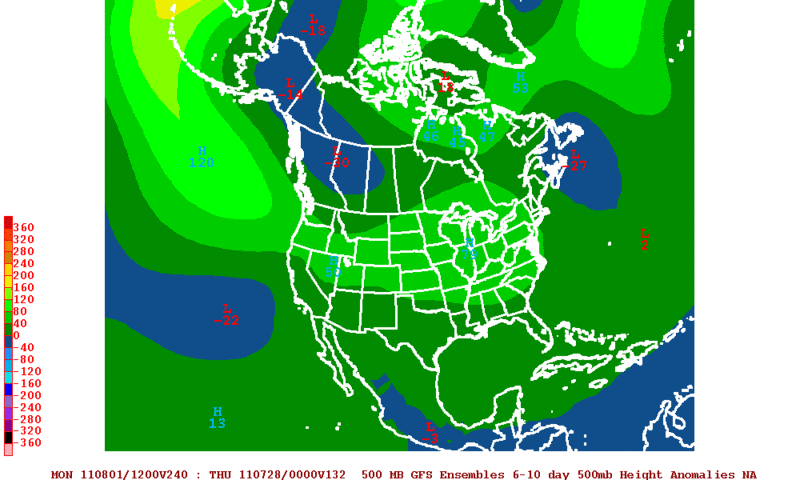
Looking at the long range GFS&ECMWF Ensembles the ridge is forecast to be strong thus my interest level of 90l is rather high right now. Looking at forecast 500mb 6-10 day mean it looks like 90l may be a player for the western gulf coast by next weekend.
12zGFS Ensembles
12zECMWF Ensembles
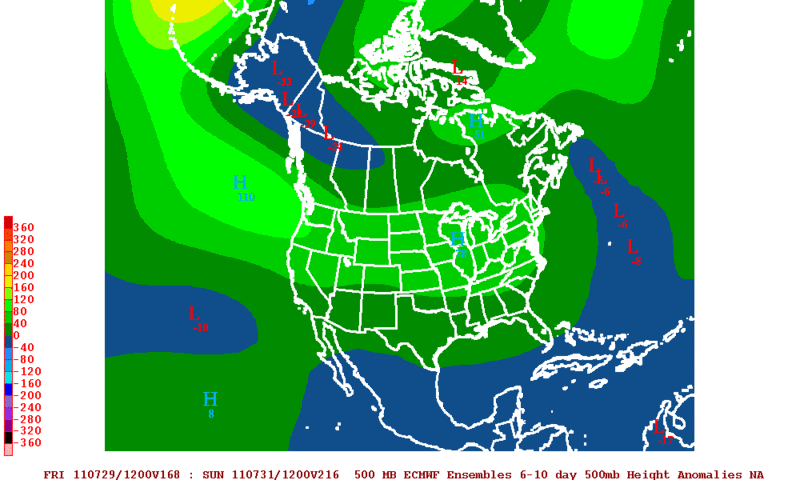
Of course things can change drastically when we are talking about long range forecast but just stating my opinion on what I see in the forecast of the overall pattern.
12zGFS Ensembles
12zECMWF Ensembles
Of course things can change drastically when we are talking about long range forecast but just stating my opinion on what I see in the forecast of the overall pattern.
0 likes
The following post is NOT an official forecast and should not be used as such. It is just the opinion of the poster and may or may not be backed by sound meteorological data. It is NOT endorsed by any professional institution including storm2k.org For Official Information please refer to the NHC and NWS products.

Re: ATL: INVEST 90L - Discussion
I agree with the banding feature beginning to take shape. Looks good but still a ways to go to get a LLC....
convection is all over the place and waning attm. I am not sure what you mean about crossing 15N...
http://rammb.cira.colostate.edu/ramsdis ... opical.asp
convection is all over the place and waning attm. I am not sure what you mean about crossing 15N...
http://rammb.cira.colostate.edu/ramsdis ... opical.asp
Last edited by ROCK on Fri Jul 22, 2011 11:02 pm, edited 1 time in total.
0 likes

Re: ATL: INVEST 90L - Discussion
Downdraft wrote:ROCK wrote:
one thing I observed down in SoFlo yesterday for work is that you guys sure build some big hotels right on the beach. Surely those have been built to withstand Cat5 intensity?.....
I don't think anything anywhere on the Florida coast was built to withstand CAT5 intensity.
Good point about buildings withstanding Cat 5. Not sure if many anywhere can do that!
I live down here in So. Fla and made an infrequent trip to South Beach yesterday with an out of town visitor and can attest to the scenery too.
0 likes
-
Rgv20
- S2K Supporter
- Posts: 2466
- Age: 39
- Joined: Wed Jan 05, 2011 5:42 pm
- Location: Edinburg/McAllen Tx
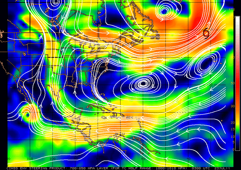
90l should keep moving west in the short term based on the latest steering chart.
0 likes
The following post is NOT an official forecast and should not be used as such. It is just the opinion of the poster and may or may not be backed by sound meteorological data. It is NOT endorsed by any professional institution including storm2k.org For Official Information please refer to the NHC and NWS products.

Re: ATL: INVEST 90L - Discussion
Looks like the center of future TD or DON is passing between St. Lucia and Martinique. I'll put it at 60% in the morning, just my guess!
0 likes
The following post is NOT an official forecast and should not be used as such. It is just the opinion of the poster and may or may not be backed by sound meteorological data. It is NOT endorsed by any professional institution including storm2k.org For Official Information please refer to the NHC and NWS products.
-
vbhoutex

- Storm2k Executive
- Posts: 29148
- Age: 74
- Joined: Wed Oct 09, 2002 11:31 pm
- Location: Cypress, TX
- Contact:
Re: ATL: INVEST 90L - Models
cycloneye wrote:Blown Away wrote:cycloneye wrote:Michael,notice the track of TVCN,a very interesting one for sure.
Luis the TVCN graphic is the same for the 18z & 00z? Curious why you think it's interesting? I do understand the NHC likes to follow the TVCN blend.
Almost the same. Is interesting as it tracks South of Cuba after going thru the SW part of Hispanola.Of course,nothing is in stone as we dont have yet a bonifide LLC.
There wouldn't be much left of any system taking the TVCN track after it goes through Hispaniola as shown. That is where some of the highest mountains on the island are. At a minimum it would be hugely disrupted.
0 likes
Skywarn, C.E.R.T.
Please click below to donate to STORM2K to help with the expenses of keeping the site going:

Please click below to donate to STORM2K to help with the expenses of keeping the site going:
-
MGC

- S2K Supporter
- Posts: 5940
- Joined: Sun Mar 23, 2003 9:05 pm
- Location: Pass Christian MS, or what is left.
Re: ATL: INVEST 90L - Discussion
With 90L about to pass through the islands we should find out if there is a surface circulation. I doubt one is established yet....but I could be wrong. 90L continues to become better organized and the most concentrated area of convection does appear to be located just south of 15N. Yep, us in the GOM area are going to have to keep an eye on this one.....MGC
0 likes

Re: ATL: INVEST 90L - Discussion
With this system developing so quickly i assume it puts the central gulf coast/ florida at risk a lot more than texas or mexico?
0 likes
Re: ATL: INVEST 90L - Discussion
lebron23 wrote:With this system developing so quickly i assume it puts the central gulf coast/ florida at risk a lot more than texas or mexico?
I'd say let's see what the models say once they get some data from the Gulfstream plane that I guess will be flown out there in a day or 2. Till then anyone from CA to NC/east coast and most of the Caribbean ilses.
0 likes
The following post is NOT an official forecast and should not be used as such. It is just the opinion of the poster and may or may not be backed by sound meteorological data. It is NOT endorsed by any professional institution including storm2k.org For Official Information please refer to the NHC and NWS products.
Re: ATL: INVEST 90L - Discussion
0 likes
Who is online
Users browsing this forum: No registered users and 14 guests