
ATL: RINA - Post-Tropical - Discussion
Moderator: S2k Moderators
-
SFLcane

- S2K Supporter

- Posts: 10281
- Age: 48
- Joined: Sat Jun 05, 2010 1:44 pm
- Location: Lake Worth Florida
Re: ATL: INVEST 96L - Discussion
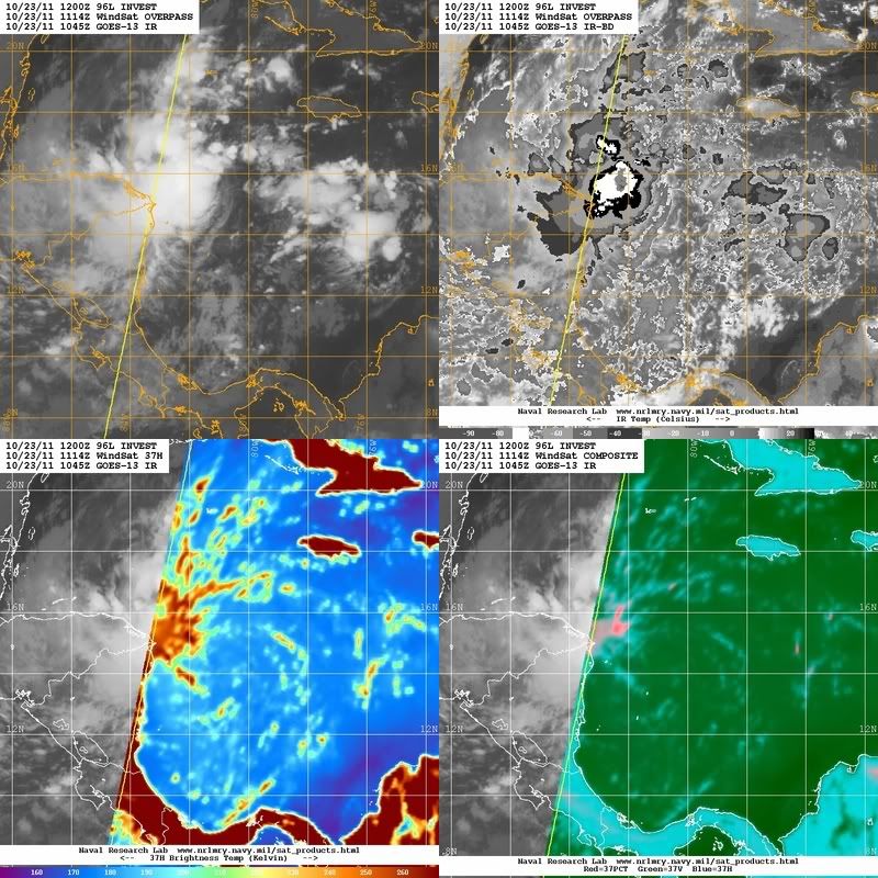
Convection is on the increase even though it is still somewhat displaced from the low level circulation.
0 likes


Re: ATL: INVEST 96L - Discussion
SFLcane wrote:Convection is on the increase even though it is still somewhat displaced from the low level circulation.
[img]http://www.ssd.noaa.gov/goes/flt/t1/rb.jpg
Statement that sums up the year. I wish I had a dollar for everytime I heard that.
0 likes
The following post is NOT an official forecast and should not be used as such. It is just the opinion of the poster and may or may not be backed by sound meteorological data. It is NOT endorsed by any professional institution including storm2k.org For Official Information please refer to the NHC and NWS products.
-
SFLcane
- S2K Supporter
- Posts: 10281
- Age: 48
- Joined: Sat Jun 05, 2010 1:44 pm
- Location: Lake Worth Florida
Re: ATL: INVEST 96L - Discussion
blp wrote:SFLcane wrote:Convection is on the increase even though it is still somewhat displaced from the low level circulation.
[img]http://www.ssd.noaa.gov/goes/flt/t1/rb.jpg
Statement that sums up the year. I wish I had a dollar for everytime I heard that.
Plenty of nakedness this year thats for sure. Fortunately for sfl if the gfs is correct 40-60 kt winds aloft wait for it in the gulf.
0 likes
-
cycloneye

- Admin

- Posts: 149426
- Age: 69
- Joined: Thu Oct 10, 2002 10:54 am
- Location: San Juan, Puerto Rico
Re: ATL: INVEST 96L - Discussion
This mornings discussion by Dr Jeff Masters:
A region of disturbed weather in the Western Caribbean (Invest 96L) has become more organized this morning, and is close to tropical depression status. A hurricane hunter aircraft is scheduled to investigate 96L this afternoon at 2 pm EDT to see if a tropical depression has formed. The system is located just offshore from the Nicaragua/Honduras border, and is bringing heavy rains to northeastern Honduras. Visible satellite loops show that 96L is close to having a well-developed surface circulation, but the heavy thunderstorm activity is all on the west side of the center, due to a large region of dry air to the east. Wind shear is a moderate 10 - 20 knots due to strong upper-level winds out of the east, and these winds are injecting dry air into 96L's east side, keeping any heavy thunderstorms from developing on that side. Water temperatures are very warm, 29 - 30°C, and these warm waters extend to great depth.
Forecast for 96L
I expect 96L will be able to organize into a tropical depression later today or on Monday, though this process will be slowed by the dry air to the storm's east, and perhaps by proximity to the land areas of Nicaragua and Honduras. NHC gave 96L a 60% chance of developing into a tropical depression by Tuesday in their 8 am Tropical Weather Outlook today. Steering currents favor a motion to the west-northwest or northwest, and it is likely that heavy rains from 96L will spread over Belize by Tuesday night, when the storm will probably be called Tropical Storm Rina. Heavy rains from the storm will spread over Mexico's Yucatan Peninsula, including Cozumel and Cancun, by Wednesday afternoon. On Wednesday, 96L will be encountering a dry airmass with high wind shear that lies over the extreme northwestern Caribbean. Since 96L is a small storm, these hostile conditions should cause the storm to weaken significantly before any potential landfall occurs.
0 likes
Visit the Caribbean-Central America Weather Thread where you can find at first post web cams,radars
and observations from Caribbean basin members Click Here
and observations from Caribbean basin members Click Here
Re: ATL: INVEST 96L - Discussion
I think it is well into TD. They're probably stalling because dry air east and west could bust this down quickly. I think once it goes above Honduras it will wrap the dry east quadrant. On the move now. Starting to show curvature.
0 likes
-
HurricaneWarning92
- Category 2

- Posts: 520
- Joined: Sat Jul 23, 2011 4:33 pm
- Location: Pembroke Pines, S. Florida (Lat: 26.00N, Lon: 80.22W)
Also, because its such a small system, there is the possibility of it to intensify quickly.
0 likes
The posts in this forum are NOT official forecast and should not be used as such. They are just the opinion of the poster and may or may not be backed by sound meteorological data. They are NOT endorsed by any professional institution or storm2k.org. For official information, please refer to the NHC and NWS products.

ATL: RINA - Recon Discussion
cycloneye wrote:The first mission is planned to depart at 11:00 AM EDT. But,NHC didn't mention it at 8 AM TWO. Let's see what occurs.
SUSPECT AREA (WESTERN CARIBBEAN)
FLIGHT ONE -- TEAL 70
A. 23/1900Z
B. AFXXX 01KKA INVEST
C. 23/1500Z
D. 14.6N 82.5W
E. 23/1830Z TO 23/2230Z
F. SFC TO 10,000 FT
If its getting there at 19z, is probably not until around 1 PM EDT that it departs.
Last edited by cycloneye on Sun Oct 23, 2011 9:37 pm, edited 3 times in total.
Reason: To change from TD to Rina
Reason: To change from TD to Rina
0 likes
-
lrak

- S2K Supporter
- Posts: 1770
- Age: 59
- Joined: Thu Jun 21, 2007 2:48 pm
- Location: Corpus Christi, TX
Re: ATL: INVEST 96L - Discussion
Man this thing really has spun up over the last several hours.
0 likes
AKA karl
Also
Personal Forecast Disclaimer:
My posts on this forum are NOT official forecast and should not be used as such. My posts are my basic observations and are definitely not backed by any "well some" meteorological knowledge. For official information, please refer to the NHC and NWS products.
Also
Personal Forecast Disclaimer:
My posts on this forum are NOT official forecast and should not be used as such. My posts are my basic observations and are definitely not backed by any "well some" meteorological knowledge. For official information, please refer to the NHC and NWS products.
-
cycloneye
- Admin
- Posts: 149426
- Age: 69
- Joined: Thu Oct 10, 2002 10:54 am
- Location: San Juan, Puerto Rico
Re: ATL: INVEST 96L - Recon Discussion
NDG,to let you know that I split your post from the main recon thread and made it as recon discussion thread.
Depends from where the plane departs,from Biloxi or from another base closer.
Depends from where the plane departs,from Biloxi or from another base closer.
0 likes
Visit the Caribbean-Central America Weather Thread where you can find at first post web cams,radars
and observations from Caribbean basin members Click Here
and observations from Caribbean basin members Click Here
-
cycloneye
- Admin
- Posts: 149426
- Age: 69
- Joined: Thu Oct 10, 2002 10:54 am
- Location: San Juan, Puerto Rico
Re: ATL: INVEST 96L - Recon
Plane departed from Keesler base.
URNT15 KNHC 231544
AF306 01KKA INVEST HDOB 01 20111023
153430 3029N 08854W 9563 00517 0167 +142 +005 011004 005 /// /// 03
153500 3030N 08856W 9301 00755 0164 +131 +018 352010 015 /// /// 03
153530 3031N 08858W 8897 01121 0154 +115 +067 334018 019 /// /// 03
153600 3030N 08900W 8569 01446 0168 +099 +037 335019 021 /// /// 03
153630 3029N 08901W 8223 01822 0179 +091 +005 350015 020 /// /// 03
153700 3028N 08903W 7895 02131 0165 +079 -041 346007 009 /// /// 03
153730 3027N 08905W 7628 02408 0145 +069 -052 298007 007 /// /// 03
153800 3026N 08906W 7364 02692 0133 +068 -043 292008 009 /// /// 03
153830 3025N 08908W 7147 02958 0143 +052 -040 295009 009 /// /// 03
153900 3023N 08910W 6962 03170 0147 +034 -043 318009 010 /// /// 03
153930 3022N 08912W 6740 03424 0156 +014 -046 311014 015 /// /// 03
154000 3021N 08914W 6515 03696 0168 -008 -051 305018 018 /// /// 03
154030 3020N 08915W 6331 03929 0165 -027 -057 303021 022 /// /// 03
154100 3019N 08917W 6150 04175 0183 -047 -062 303022 023 /// /// 03
154130 3017N 08918W 5953 04401 0166 -064 -066 300021 022 002 000 03
154200 3015N 08918W 5792 04617 0132 -064 -072 291024 028 001 000 00
154230 3013N 08918W 5636 04831 0102 -063 -080 278025 026 001 000 03
154300 3011N 08917W 5496 05031 0161 -079 -087 285031 032 000 000 00
154330 3009N 08917W 5357 05226 0166 -096 //// 289033 034 003 000 05
154400 3007N 08917W 5228 05417 0174 -112 //// 287033 033 /// /// 05
$$
0 likes
Visit the Caribbean-Central America Weather Thread where you can find at first post web cams,radars
and observations from Caribbean basin members Click Here
and observations from Caribbean basin members Click Here
-
cycloneye
- Admin
- Posts: 149426
- Age: 69
- Joined: Thu Oct 10, 2002 10:54 am
- Location: San Juan, Puerto Rico
Re: ATL: INVEST 96L - Recon Discussion
Plane just took off from Biloxi.
0 likes
Visit the Caribbean-Central America Weather Thread where you can find at first post web cams,radars
and observations from Caribbean basin members Click Here
and observations from Caribbean basin members Click Here
-
cycloneye
- Admin
- Posts: 149426
- Age: 69
- Joined: Thu Oct 10, 2002 10:54 am
- Location: San Juan, Puerto Rico
Re: ATL: INVEST 96L - Recon
Who wants to post google graphics of this long mission?
000
URNT15 KNHC 231554
AF306 01KKA INVEST HDOB 02 20111023
154430 3004N 08917W 5111 05591 0179 -126 //// 285032 032 /// /// 05
154500 3002N 08917W 4979 05788 0185 -136 //// 278034 035 050 002 05
154530 3000N 08917W 4863 05969 0193 -150 //// 276035 035 029 000 05
154600 2958N 08917W 4764 06126 0198 -162 //// 271034 035 048 003 05
154630 2956N 08917W 4668 06280 0205 -175 //// 268033 033 059 001 05
154700 2954N 08917W 4571 06442 0213 -187 //// 266032 032 /// /// 05
154730 2952N 08917W 4478 06600 0221 -201 //// 266032 033 /// /// 05
154800 2950N 08916W 4391 06745 0227 -213 //// 266034 035 021 000 05
154830 2948N 08916W 4305 06892 0232 -222 //// 264034 035 /// /// 05
154900 2946N 08916W 4234 07016 0236 -229 //// 265034 034 /// /// 05
154930 2944N 08916W 4168 07132 0239 -234 //// 262039 041 007 000 05
155000 2942N 08916W 4094 07263 0243 -237 //// 260043 044 001 000 05
155030 2940N 08916W 4021 07394 0249 -240 //// 261045 045 000 000 05
155100 2938N 08916W 3944 07539 0255 -245 //// 259048 049 000 000 05
155130 2937N 08916W 3885 07651 0262 -251 //// 263050 050 000 000 05
155200 2935N 08916W 3837 07741 0266 -257 //// 264050 051 000 000 05
155230 2933N 08916W 3787 07840 0273 -264 //// 269050 050 005 000 05
155300 2931N 08916W 3763 07888 0274 -269 //// 268051 052 006 000 01
155330 2929N 08915W 3748 07912 0273 -274 //// 265055 056 005 000 05
155400 2927N 08915W 3757 07895 0271 -275 //// 264057 057 006 000 01
$$
0 likes
Visit the Caribbean-Central America Weather Thread where you can find at first post web cams,radars
and observations from Caribbean basin members Click Here
and observations from Caribbean basin members Click Here
-
cycloneye
- Admin
- Posts: 149426
- Age: 69
- Joined: Thu Oct 10, 2002 10:54 am
- Location: San Juan, Puerto Rico
Re: ATL: INVEST 96L - Recon
URNT15 KNHC 231604
AF306 01KKA INVEST HDOB 03 20111023
155430 2925N 08915W 3762 07883 0268 -275 //// 263057 057 006 000 05
155500 2922N 08915W 3759 07886 0268 -275 //// 263057 057 /// /// 05
155530 2920N 08915W 3758 07890 0269 -276 //// 263057 057 /// /// 05
155600 2918N 08915W 3761 07885 0270 -276 //// 263056 057 /// /// 05
155630 2915N 08915W 3765 07879 0272 -278 //// 262055 055 /// /// 05
155700 2913N 08915W 3762 07890 0274 -280 //// 262054 054 /// /// 05
155730 2910N 08915W 3762 07891 0276 -280 //// 261052 053 /// /// 05
155800 2908N 08915W 3761 07896 0278 -280 //// 259051 051 /// /// 05
155830 2905N 08914W 3761 07896 0280 -280 //// 260050 051 /// /// 05
155900 2903N 08914W 3761 07898 0281 -280 //// 261051 051 /// /// 05
155930 2900N 08914W 3761 07898 0283 -281 //// 263050 050 029 000 05
160000 2858N 08914W 3762 07898 0283 -280 //// 264051 051 013 000 01
160030 2855N 08914W 3761 07902 0284 -280 //// 265051 051 013 000 01
160100 2853N 08914W 3761 07902 0285 -280 //// 268052 052 013 000 05
160130 2851N 08914W 3761 07906 0287 -280 //// 269052 052 013 000 01
160200 2848N 08914W 3761 07904 0288 -280 //// 269051 051 019 000 01
160230 2846N 08914W 3761 07906 0289 -280 //// 270050 051 020 000 01
160300 2843N 08913W 3762 07906 0290 -280 //// 270050 050 020 000 01
160330 2840N 08913W 3761 07909 0292 -280 //// 268049 049 019 000 01
160400 2838N 08913W 3762 07908 0293 -277 //// 268049 049 019 000 01
$$
0 likes
Visit the Caribbean-Central America Weather Thread where you can find at first post web cams,radars
and observations from Caribbean basin members Click Here
and observations from Caribbean basin members Click Here
-
cycloneye
- Admin
- Posts: 149426
- Age: 69
- Joined: Thu Oct 10, 2002 10:54 am
- Location: San Juan, Puerto Rico
Re: ATL: INVEST 96L - Recon
URNT15 KNHC 231614
AF306 01KKA INVEST HDOB 04 20111023
160430 2835N 08913W 3762 07910 0295 -280 //// 270048 049 020 000 01
160500 2833N 08913W 3762 07911 0296 -279 //// 272049 049 021 000 01
160530 2830N 08913W 3761 07914 0297 -276 //// 274049 049 020 000 01
160600 2828N 08913W 3762 07913 0297 -279 //// 275049 049 020 000 01
160630 2825N 08913W 3760 07916 0298 -275 //// 273049 049 020 000 01
160700 2823N 08913W 3761 07914 0297 -275 //// 275048 049 020 000 01
160730 2820N 08912W 3761 07915 0297 -276 //// 275047 048 020 000 01
160800 2818N 08912W 3761 07915 0299 -275 //// 272046 046 020 000 05
160830 2815N 08912W 3760 07920 0300 -273 //// 269046 047 /// /// 05
160900 2813N 08911W 3762 07915 0302 -275 //// 270044 045 022 000 01
160930 2810N 08910W 3762 07916 0301 -275 //// 271042 044 022 000 05
161000 2808N 08909W 3762 07915 0301 -275 //// 269044 044 023 000 01
161030 2805N 08907W 3762 07917 0301 -271 //// 267044 045 021 001 01
161100 2803N 08906W 3761 07918 0302 -268 //// 266046 047 020 000 01
161130 2800N 08905W 3761 07921 0303 -268 //// 269046 046 020 000 05
161200 2758N 08904W 3762 07917 0303 -269 //// 269045 046 020 000 01
161230 2755N 08903W 3761 07921 0304 -265 -268 266046 047 020 000 00
161300 2753N 08901W 3762 07923 0307 -265 -267 264045 045 019 000 00
161330 2750N 08900W 3762 07922 0308 -265 -268 264044 045 019 000 03
161400 2748N 08859W 3762 07923 0308 -265 -270 264044 044 019 000 00
$$
;
0 likes
Visit the Caribbean-Central America Weather Thread where you can find at first post web cams,radars
and observations from Caribbean basin members Click Here
and observations from Caribbean basin members Click Here
Re: ATL: INVEST 96L - Discussion
NWS Miami Discussion this morning:
NHC CONTINUES TO MONITOR AREA OF LOW PRESSURE ACROSS THE NW CARIBBEAN
AT THIS TIME GIVING IT A HIGH CHANCE OF DEVELOPMENT. MODEL GUIDANCE
IN GENERAL MAINTAIN THE SYSTEM SOUTH OF THE AREA THROUGH THE
COMING WEEK WITH SURFACE FRONT APPROACHING SOUTH FLORIDA LATE IN
THE WEEK PROBABLY TAPPING SOME OF ITS MOISTURE WHICH COULD ENHANCE
THE CHANCE OF RAIN WITH THE FRONT. HOWEVER, AT THIS TIME, THE
UNCERTAINTY WITH THAT SYSTEM IS LARGE AND WILL CONTINUE TO MONITOR
ITS EVOLUTION THROUGH THE WEEK.
0 likes
-
cycloneye
- Admin
- Posts: 149426
- Age: 69
- Joined: Thu Oct 10, 2002 10:54 am
- Location: San Juan, Puerto Rico
Re: ATL: INVEST 96L - Recon
Decoded observation.
Product: Air Force Tropical RECCO Message (URNT11 KNHC)
Transmitted: 23rd day of the month at 16:16Z
Aircraft: Air Force Aircraft (Last 3 digits of the tail number are 306)
Mission Purpose: Investigate tenth suspect area (flight in the North Atlantic basin)
Mission Number: 1
Observation Number: 01
Observation Time: Sunday, 16:12Z
Radar Capability: Yes
Aircraft Altitude: Below 10,000 meters
Coordinates: 28.0N 89.1W
Location: 148 miles (239 km) to the SSE (157°) from New Orleans, LA, USA.
Turbulence: None
Conditions Along Flight Route: In the clear
Pressure Altitude: 7,620 meters
Flight Level Wind: From 270° at 45 knots (From the W at ~ 51.7 mph)
- The above is a spot wind.
- Winds were obtained using doppler radar or inertial systems.
Flight Level Temperature: -27°C
Flight Level Dew Point: -27°C
Weather (within 30 nautical miles): Scattered clouds (trace to 4/8 cloud coverage)
400 mb Surface Altitude: 7,470 geopotential meters
0 likes
Visit the Caribbean-Central America Weather Thread where you can find at first post web cams,radars
and observations from Caribbean basin members Click Here
and observations from Caribbean basin members Click Here
-
cycloneye
- Admin
- Posts: 149426
- Age: 69
- Joined: Thu Oct 10, 2002 10:54 am
- Location: San Juan, Puerto Rico
Re: ATL: INVEST 96L - Discussion
Pressure Altitude: 7,620 meters
Flight Level Wind: From 270° at 45 knots (From the W at ~ 51.7 mph)
Shear is prohibitive in the GOM as the data from plane shows.
Flight Level Wind: From 270° at 45 knots (From the W at ~ 51.7 mph)
Shear is prohibitive in the GOM as the data from plane shows.
0 likes
Visit the Caribbean-Central America Weather Thread where you can find at first post web cams,radars
and observations from Caribbean basin members Click Here
and observations from Caribbean basin members Click Here
-
cycloneye
- Admin
- Posts: 149426
- Age: 69
- Joined: Thu Oct 10, 2002 10:54 am
- Location: San Juan, Puerto Rico
Re: ATL: INVEST 96L - Recon
URNT15 KNHC 231624
AF306 01KKA INVEST HDOB 05 20111023
161430 2745N 08858W 3762 07923 0308 -265 -271 263043 044 021 000 00
161500 2743N 08857W 3762 07924 0309 -265 -272 263045 045 020 000 00
161530 2741N 08855W 3762 07924 0310 -264 -273 263046 047 021 001 00
161600 2738N 08854W 3759 07929 0310 -260 -274 263049 050 022 000 00
161630 2736N 08853W 3762 07927 0312 -259 -274 261051 052 022 000 00
161700 2733N 08852W 3759 07934 0314 -257 -274 260052 053 022 000 00
161730 2731N 08851W 3762 07930 0314 -255 -275 261054 054 022 000 00
161800 2728N 08850W 3762 07930 0315 -255 -276 261055 055 021 001 00
161830 2726N 08848W 3762 07931 0316 -252 -276 263055 056 020 000 00
161900 2724N 08847W 3762 07931 0316 -250 -276 263055 056 021 000 00
161930 2721N 08846W 3761 07934 0317 -250 -276 264055 055 020 000 00
162000 2719N 08845W 3761 07933 0317 -252 -276 263054 055 020 000 00
162030 2717N 08844W 3761 07935 0318 -251 -277 262053 053 020 000 00
162100 2714N 08843W 3761 07937 0320 -250 -278 262052 052 021 000 00
162130 2712N 08841W 3762 07937 0322 -250 -277 262052 053 020 000 00
162200 2709N 08840W 3759 07942 0323 -250 -276 262053 053 020 000 00
162230 2707N 08839W 3761 07940 0324 -251 -277 262052 052 020 000 00
162300 2705N 08838W 3761 07941 0325 -250 -276 262052 053 019 000 00
162330 2702N 08837W 3762 07941 0325 -250 -276 263052 053 019 000 00
162400 2700N 08836W 3762 07941 0326 -250 -277 265053 053 021 000 00
$$
0 likes
Visit the Caribbean-Central America Weather Thread where you can find at first post web cams,radars
and observations from Caribbean basin members Click Here
and observations from Caribbean basin members Click Here
Who is online
Users browsing this forum: No registered users and 12 guests