
http://weather.rap.ucar.edu/model/index.php?model=gfs
when you click on the hour, check upper right corner of image to see if it is the current, which is 12z, right now I believe.
ATL: LEE - Remnants - Discussion
Moderator: S2k Moderators
Re: ATL: LEE - Tropical Storm - Discussion
rain shield on local radar looks to be making progress towards Galveston Bay...
e posts in this forum are NOT official forecast and should not be used as such. They are just the opinion of the poster and may or may not be backed by sound meteorological data. They are NOT endorsed by any professional institution or storm2k.org. For official information, please refer to the NHC and NWS products.
e posts in this forum are NOT official forecast and should not be used as such. They are just the opinion of the poster and may or may not be backed by sound meteorological data. They are NOT endorsed by any professional institution or storm2k.org. For official information, please refer to the NHC and NWS products.
0 likes
-
setxsunshine
- Tropical Low

- Posts: 37
- Joined: Fri Jul 23, 2010 10:26 am
- Location: SE Texas
this system has never had a true "tropical" look to it throughout its entire evolution. it has always had a frontal look which has since become much more pronouned. this has always been a case of looking for the "weather" associated with the system vs the center since there's frequently been a good separation between the two. it looks to me like the most intense weather is well east of the center in that heavy convective band crossing the coast from se la to the wrn florida panhandle. even east of there, a large band is about to dump on the apalachicola/panama city region. should it hold together some very impressive rains may accumulate well east in the the fl panhandle. look at just how far away that region is from the "center". or, compare that to how close Houston is to the center and is getting nothing at this point. as is frequently the case, position relative to the center counts for more than distance from the center.
The posts in this forum are NOT official forecast and should not be used as such. They are just the opinion of the poster and may or may not be backed by sound meteorological data. They are NOT endorsed by any professional institution or storm2k.org. For official information, please refer to the NHC and NWS products.
The posts in this forum are NOT official forecast and should not be used as such. They are just the opinion of the poster and may or may not be backed by sound meteorological data. They are NOT endorsed by any professional institution or storm2k.org. For official information, please refer to the NHC and NWS products.
0 likes

Re: ATL: LEE - Tropical Storm - Discussion
jinftl wrote:Cool image...some pretty big blowups south of boothville...rain for SE LA may not be winding down for long...
Yeah I noticed that. Depending on what those two centers decide on doing, there are a few scenarios where we in Baton Rouge get a lot more rain. If the entierty of the system moves east, we will get the backside of the rain shield. If it moves south with that other center, we'll get the rain shield again. If the convection fires up like it looks like its doing, we will get the result of that. The only thing that will make this storm over is if it moves northeast, and the convection doesnt refire. Then we honestly arent going to get much more rain.
0 likes
GFS--12 hours--still offshore
GFS--18 hours--right on the coast--drifting WNW
GFS--24 hours--right on the coast--almost stationary
GFS--30 hours--right on the coast--still stationary
GFS--36 hours--right on the coast--still stationary
GFS--42 hours--right on the coast--drifting SOUTHEAST
GFS--48 hours--near New Orleans--moving ENE
GFS--54 hours--over southeast Mississippi--moving NE
GFS--60 hours--over south central Alabama--moving NE
Last edited by rockyman on Sat Sep 03, 2011 11:01 am, edited 1 time in total.
0 likes
-
HenkL
- S2K Supporter

- Posts: 2401
- Joined: Fri Sep 10, 2004 5:33 pm
- Location: Groningen, The Netherlands
- Contact:
000
URNT15 KNHC 031549
AF307 0513A LEE HDOB 30 20110903
154000 2910N 09121W 8430 01456 //// +179 //// 186030 030 027 000 05
154030 2910N 09119W 8428 01461 //// +179 //// 185029 029 026 000 05
154100 2909N 09118W 8430 01457 //// +180 //// 185029 030 027 001 01
154130 2908N 09116W 8431 01458 //// +180 //// 187030 030 028 000 05
154200 2907N 09115W 8429 01460 //// +181 //// 188031 031 027 000 01
154230 2907N 09113W 8429 01462 //// +179 //// 188031 032 026 000 05
154300 2906N 09112W 8429 01463 //// +180 //// 193031 032 027 000 05
154330 2905N 09110W 8430 01462 //// +182 //// 195032 032 026 000 05
154400 2904N 09109W 8426 01466 //// +183 //// 195031 032 029 000 05
154430 2903N 09108W 8433 01463 //// +185 //// 195031 032 029 000 05
154500 2902N 09106W 8433 01467 //// +185 //// 195033 034 028 000 05
154530 2902N 09105W 8429 01468 //// +184 //// 195033 034 028 000 05
154600 2901N 09103W 8428 01470 //// +186 //// 197033 033 028 000 05
154630 2901N 09101W 8430 01470 //// +185 //// 199031 032 025 000 05
154700 2900N 09059W 8428 01476 //// +184 //// 198031 033 025 000 05
154730 2900N 09057W 8434 01469 //// +181 //// 196033 034 025 000 05
154800 2900N 09055W 8429 01476 //// +180 //// 196034 035 026 000 05
154830 2900N 09054W 8428 01477 //// +178 //// 198035 036 028 000 01
154900 2900N 09052W 8429 01478 //// +170 //// 196031 033 027 000 01
154930 2900N 09050W 8432 01473 //// +173 //// 192033 035 028 000 01
0 likes
Re: ATL: LEE - Tropical Storm - Discussion
I just checked my rain gauge and I have 5 inches (up from the trace of rain and one pine needle that was in it late last night). My daughter, who lives about 2 miles from me, had 5 inches in her gauge too. Most of it came in one heavy downpour around 6:00 this morning. Numerous streets and neighborhoods in my area have flooding, and one friend got water in one corner of her house. I did too, but it's in a low corner of my sun room that always gets water with a heavy rain, so that's no big deal (seepage between slab & floor - add on room built by previous owner). Right now, it's quite breezy with light rain.
Supposedly, our "bad" rain isn't due to start until later today. It's going to be a long weekend.
Supposedly, our "bad" rain isn't due to start until later today. It's going to be a long weekend.
0 likes
-
dwsqos2
Re: ATL: LEE - Tropical Storm - Discussion
Well, one thing that supports a subtropical classification is the presence of an upper trough near the surface circulation. With an entirely tropical cyclone, an upper-level anticyclone would be expected.
0 likes
-
cycloneye

- Admin

- Posts: 149431
- Age: 69
- Joined: Thu Oct 10, 2002 10:54 am
- Location: San Juan, Puerto Rico
Re: ATL: LEE - Tropical Storm - Discussion
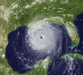
Updated saved loop of the two centers.

0 likes
Visit the Caribbean-Central America Weather Thread where you can find at first post web cams,radars
and observations from Caribbean basin members Click Here
and observations from Caribbean basin members Click Here
-
SETXPTNeches
- Tropical Low
- Posts: 26
- Age: 63
- Joined: Sun Jan 09, 2011 2:10 pm
- Location: Port Neches TX
Re: ATL: LEE - Models
Looking at local radar this TS is hanging right offshore only a few degrees to our SE. Per NHC it is actually moving the the NNW (very slowly) and the statement that was issued said to NOT pay that much attention to the possible track, it could leave you in a vulnarable situation if you are in coastal areas. Just thought I would mention. Go to NHC and type in your zip code and read the statements. These are precaustionary, I am sure, but it appears that Lee is still very unpredictable even so close to land.
0 likes
PN-G Indians #1
Rita & Ike
The following post is NOT an official forecast and should not be used as such. It is just the opinion of the poster and may or may not be backed by sound meteorological data. It is NOT endorsed by any professional institution including storm2k.org For Official Information please refer to the NHC and NWS products.
-
WeatherGuesser
- Category 5

- Posts: 2672
- Joined: Tue Jun 29, 2010 6:46 am
NEW ORLEANS | Sat Sep 3, 2011 10:51am EDT
NEW ORLEANS (Reuters) - Louisiana's Jefferson Parish has ordered a mandatory evacuation for three towns as Tropical Storm Lee brings heavy rains into the area, a Parish official said on Saturday.
Jefferson Parish Council member Chris Roberts reported the evacuation was ordered for the towns of Lafitte, Crown Point and Barataria.
Heavy rains and tidal surge pushed Bayou Barataria over its banks in the area near New Orleans, and Roberts said if residents in low-lying spots didn't leave now, it could be a couple of days before they were able to get out.
http://www.reuters.com/article/2011/09/ ... 9L20110903
0 likes
-
HenkL
- S2K Supporter
- Posts: 2401
- Joined: Fri Sep 10, 2004 5:33 pm
- Location: Groningen, The Netherlands
- Contact:
000
URNT15 KNHC 031559
AF307 0513A LEE HDOB 31 20110903
155000 2900N 09048W 8430 01477 //// +176 //// 194034 034 029 000 05
155030 2900N 09046W 8429 01478 //// +176 //// 191033 034 030 001 05
155100 2900N 09044W 8431 01477 //// +179 //// 193031 032 027 000 05
155130 2900N 09042W 8426 01484 //// +178 //// 193033 035 025 000 05
155200 2900N 09040W 8429 01482 //// +184 //// 193035 036 025 000 01
155230 2900N 09038W 8433 01481 //// +181 //// 193036 036 026 000 05
155300 2900N 09036W 8426 01487 //// +180 //// 189034 034 026 000 05
155330 2900N 09034W 8430 01485 //// +180 //// 192033 034 026 001 01
155400 2900N 09032W 8430 01486 //// +182 //// 190034 034 024 000 05
155430 2900N 09030W 8432 01486 //// +183 //// 187033 033 025 000 05
155500 2900N 09029W 8429 01488 //// +180 //// 188033 034 025 000 01
155530 2900N 09027W 8430 01490 //// +179 //// 189034 034 026 000 05
155600 2900N 09025W 8430 01489 //// +178 //// 187034 034 025 000 05
155630 2900N 09023W 8426 01495 //// +176 //// 190034 035 025 000 05
155700 2900N 09021W 8433 01488 //// +178 //// 191033 035 026 000 05
155730 2900N 09019W 8428 01495 //// +177 //// 192032 033 024 000 05
155800 2900N 09017W 8428 01495 //// +180 //// 192034 035 025 000 05
155830 2900N 09015W 8430 01495 //// +180 //// 193033 034 025 000 01
155900 2900N 09013W 8430 01495 //// +182 //// 193031 032 027 002 01
155930 2900N 09011W 8436 01489 //// +166 //// 183031 032 035 006 01
0 likes
Re: ATL: LEE - Tropical Storm - Discussion
Interesting to watch - but a system with multiple centers is not going to intensify in a hurry...esp if the main center is moving onshore. Doesn't mean the flooding and rainfall (esp well east of the center will end with landfall) - but as far as this consolidating and intensifying like a more intense tropical system, the time for that is just about done.
cycloneye wrote:Updated saved loop of the two centers.
0 likes
This 12z NAM "projected radar" loop clearly shows the system splitting, with a lot of the convection moving northeast, and a piece of energy breaking off and moving back out into the Gulf.
http://raleighwx.americanwx.com/models/ ... ELoop.html
http://raleighwx.americanwx.com/models/ ... ELoop.html
0 likes
Re: ATL: LEE - Tropical Storm - Discussion
.UPDATE...
HAVE LOWERED TEMPS A FEW DEGREES ACROSS THE REGION FOR THIS
AFTERNOON AS THE WESTERN EDGE OF THE CLOUD SHIELD FROM TROPICAL
STORM LEE CONTINUES TO PUSH WESTWARD INTO SOUTHEAST TEXAS THIS
MORNING. THIS COULD LEAD TO SLIGHTLY LOWER WIND SPEEDS THIS
AFTERNOON IF WE GET LESS MIXING BUT WILL GO AHEAD AND LEAVE THE
WIND ADVISORY IN PLACE THROUGH THIS EVENING. PRECIPITATION ON THE
WESTERN EDGE OF LEE CONTINUES TO WEAKEN AS IT MOVES WESTWARD SO
NOT EXPECTING ANY INCREASE IN RAIN CHANCES THROUGH THIS AFTERNOON.
OUR BEST CHANCES FOR RAIN STILL LOOK TO BE OVERNIGHT TONIGHT
ACROSS AREAS GENERALLY ALONG AND EAST OF INTERSTATE 45. SOME SMALL
ENCOURAGEMENT FOR THIS COMES FROM A QUICK LOOK AT THE 12Z NAM RUN
WHICH SHOWS IT COMING IN WETTER FOR OUR AREA TONIGHT...IN BETTER
AGREEMENT WITH THE GFS AND ECMWF RUNS. 38
Houston/Galveston 10:30a.m.....
Personal Forecast Disclaimer:
The posts in this forum are NOT official forecast and should not be used as such. They are just the opinion of the poster and may or may not be backed by sound meteorological data. They are NOT endorsed by any professional institution or storm2k.org. For official information, please refer to the NHC and NWS products.
Last edited by underthwx on Sat Sep 03, 2011 11:09 am, edited 1 time in total.
0 likes
Re: ATL: LEE - Tropical Storm - Discussion
Is it just me, or in that latest frame is there a lot of convection forming around the lower center?
0 likes

-
Tstormwatcher

- S2K Supporter
- Posts: 3086
- Joined: Thu Oct 20, 2005 7:31 pm
- Location: New Bern, NC
Re:
rockyman wrote:This 12z NAM "projected radar" loop clearly shows the system splitting, with a lot of the convection moving northeast, and a piece of energy breaking off and moving back out into the Gulf.
http://raleighwx.americanwx.com/models/ ... ELoop.html
Very interesting run.
0 likes
Who is online
Users browsing this forum: No registered users and 17 guests