[quote="tolakram"]From recon thread, 999MB vs forecast track.
Looks like P.R. will be more affected by Irene.
ATL: IRENE - Remnants - Discussion
Moderator: S2k Moderators
-
Blown Away

- S2K Supporter

- Posts: 10253
- Joined: Wed May 26, 2004 6:17 am
Re: ATL: IRENE - Tropical Storm - Discussion
The following post is NOT an official forecast and should not be used as such. It is just the opinion of the poster and may or may not be backed by sound meteorological data. It is NOT endorsed by any professional institution including storm2k.org. For Official Information please refer to the NHC and NWS products.
IMO, the NHC will shift the track slightly right which will skim the flatter N coast of Hispaniola and miss Cuba. IMO, I'm predicting a Cat 2-3 moving towards Bahamas.
Last edited by Portastorm on Sun Aug 21, 2011 12:48 pm, edited 1 time in total.
Reason: Added forecast disclaimer
Reason: Added forecast disclaimer
0 likes
Hurricane Eye Experience: David 79, Irene 99, Frances 04, Jeanne 04, Wilma 05… Hurricane Brush Experience: Andrew 92, Erin 95, Floyd 99, Matthew 16, Irma 17, Ian 22, Nicole 22…
-
tolakram
- Admin

- Posts: 20185
- Age: 62
- Joined: Sun Aug 27, 2006 8:23 pm
- Location: Florence, KY (name is Mark)
Re: ATL: IRENE - Tropical Storm - Discussion
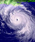
Eye like feature already?

0 likes
M a r k
- - - - -
Join us in chat: Storm2K Chatroom Invite. Android and IOS apps also available.
The posts in this forum are NOT official forecasts and should not be used as such. Posts are NOT endorsed by any professional institution or STORM2K.org. For official information and forecasts, please refer to NHC and NWS products.

True motion when accounting for the center relocations is about 275 at the moment taking a look at the latest loops...
might be a very close call for PR. Not going to miss Hispaniola to the south now either even with a due west track.
might be a very close call for PR. Not going to miss Hispaniola to the south now either even with a due west track.
0 likes
Personal Forecast Disclaimer:
The posts in this forum are NOT official forecast and should not be used as such. They are just the opinion of the poster and may or may not be backed by sound meteorological data. They are NOT endorsed by any professional institution or storm2k.org. For official information, please refer to the NHC and NWS products
The posts in this forum are NOT official forecast and should not be used as such. They are just the opinion of the poster and may or may not be backed by sound meteorological data. They are NOT endorsed by any professional institution or storm2k.org. For official information, please refer to the NHC and NWS products
-
Jevo

- S2K Supporter
- Posts: 1729
- Age: 47
- Joined: Tue Aug 03, 2004 8:45 pm
- Location: The Flemish Cap
- Contact:
Re:
dmbthestone wrote:Funny how quick things change. Yesterday everyone was talking about GOM and now we're talking bout it missing Fl to the east.
and by the end of the day many will probably be taking it back into the GOM.. Thats the reason why I love S2K.. great people for the most part and a whole lotta of speculation to get the wheels turning.. Stay tuned.. Im sure Irene even has our friends at the NHC throwing darts right now
0 likes
Disclaimer: 50% of the time I have no clue of what I am talking about. Chances are I am taking a less than educated guess that sounds good because 10 years ago I stole Mike Watkins book 'The Hurricane and its Impact'. For official information please direct yourself to the NHC and their cadre of weather geniuses.

Re: ATL: IRENE - Tropical Storm - Discussion
tolakram wrote:From recon thread, 999MB vs forecast track.

Not a fair picture to make a comparison, they were tracking an old dying center earlier this morning. I still have the new center tracking on a 285 deg heading.
Since the beginning her MLC was always to her north until this morning when the LLC reformed underneath the MLC.
0 likes
-
Battlebrick
- Tropical Storm

- Posts: 177
- Joined: Thu Sep 02, 2010 9:55 pm
Re: ATL: IRENE - Recon
what time in EST is the next flight?
0 likes
Lim_Fao on IRC.
The following post is NOT an official forecast and should not be used as such. It is just the opinion of the poster and may or may not be backed by sound meteorological data. It is NOT endorsed by any professional institution including storm2k.org. For Official Information please refer to the NHC and NWS products.
The following post is NOT an official forecast and should not be used as such. It is just the opinion of the poster and may or may not be backed by sound meteorological data. It is NOT endorsed by any professional institution including storm2k.org. For Official Information please refer to the NHC and NWS products.
000
WTNT34 KNHC 211731
TCPAT4
BULLETIN
TROPICAL STORM IRENE INTERMEDIATE ADVISORY NUMBER 4A
NWS NATIONAL HURRICANE CENTER MIAMI FL AL092011
200 PM AST SUN AUG 21 2011
...IRENE APPROACHING THE VIRGIN ISLANDS...
SUMMARY OF 200 PM AST...1800 UTC...INFORMATION
----------------------------------------------
LOCATION...17.5N 63.7W
ABOUT 70 MILES...115 KM...ESE OF ST CROIX
ABOUT 185 MI...300 KM ESE OF PONCE PUERTO RICO
MAXIMUM SUSTAINED WINDS...50 MPH...85 KM/H
PRESENT MOVEMENT...WNW OR 290 DEGREES AT 18 MPH...30 KM/H
MINIMUM CENTRAL PRESSURE...999 MB...29.50 INCHES
WATCHES AND WARNINGS
--------------------
CHANGES IN WATCHES AND WARNINGS WITH THIS ADVISORY...
THE GOVERNMENT OF ANTIGUA HAS DISCONTINUED THE TROPICAL STORM
WARNING FOR ANTIGUA...BARBUDA...MONTSERRAT...ST. KITTS...
NEVIS...AND ANGUILLA.
SUMMARY OF WATCHES AND WARNINGS IN EFFECT...
A HURRICANE WARNING IS IN EFFECT FOR...
* PUERTO RICO...VIEQUES...AND CULEBRA
* THE DOMINICAN REPUBLIC FROM THE SOUTHERN BORDER WITH HAITI TO CABO
FRANCES VIEJO ON THE NORTH COAST
A HURRICANE WATCH IS IN EFFECT FOR...
* U.S. VIRGIN ISLANDS
A TROPICAL STORM WARNING IS IN EFFECT FOR...
* U.S. VIRGIN ISLANDS
* BRITISH VIRGIN ISLANDS
* NORTHERN COAST OF THE DOMINICAN REPUBLIC FROM THE HAITI BORDER
EASTWARD TO CABO FRANCES VIEJO
* HAITI
A TROPICAL STORM WATCH IS IN EFFECT FOR...
* SOUTHEASTERN BAHAMAS AND THE TURKS AND CAICOS ISLANDS
FOR STORM INFORMATION SPECIFIC TO YOUR AREA IN THE UNITED
STATES...PLEASE MONITOR PRODUCTS ISSUED BY YOUR LOCAL NATIONAL
WEATHER SERVICE FORECAST OFFICE. FOR STORM INFORMATION SPECIFIC TO
YOUR AREA OUTSIDE THE UNITED STATES...PLEASE MONITOR PRODUCTS
ISSUED BY YOUR NATIONAL METEOROLOGICAL SERVICE.
DISCUSSION AND 48-HOUR OUTLOOK
------------------------------
AT 200 PM AST...1800 UTC...THE CENTER OF TROPICAL STORM IRENE WAS
LOCATED NEAR LATITUDE 17.5 NORTH...LONGITUDE 63.7 WEST. IRENE IS
MOVING TOWARD THE WEST-NORTHWEST NEAR 18 MPH...30 KM/H...AND THIS
MOTION IS EXPECTED TO CONTINUE FOR THE NEXT COUPLE OF DAYS WITH A
GRADUAL DECREASE IN FORWARD SPEED. ON THE FORECAST TRACK...IRENE
WILL PASS NEAR OR OVER THE U.S. VIRGIN ISLANDS LATER TODAY...NEAR OR
OVER PUERTO RICO TONIGHT...AND APPROACH THE DOMINICAN REPUBLIC ON
MONDAY.
MAXIMUM SUSTAINED WINDS ARE NEAR 50 MPH...85 KM/H...WITH HIGHER
GUSTS. SOME STRENGTHENING IS FORECAST DURING THE NEXT DAY OR
SO...AND IRENE IS EXPECTED TO BECOME A HURRICANE BY MONDAY.
TROPICAL-STORM-FORCE WINDS EXTEND OUTWARD UP TO 150 MILES...240
KM...MAINLY TO THE NORTH OF THE CENTER.
AN AIR FORCE HURRICANE HUNTER AIRCRAFT REPORTED A MINIMUM CENTRAL
PRESSURE OF 999 MB...29.50 INCHES.
HAZARDS AFFECTING LAND
----------------------
WIND...TROPICAL STORM CONDITIONS ARE EXPECTED IN THE VIRGIN ISLANDS
AND PUERTO RICO INCLUDING CULEBRA AND VIEQUES TODAY...AND IN THE
DOMINICAN REPUBLIC EARLY MONDAY. HURRICANE CONDITIONS ARE EXPECTED
OVER PUERTO RICO INCLUDING VIEQUES AND CULEBRA TONIGHT...AND OVER
THE DOMINICAN REPUBLIC ON MONDAY.
RAINFALL...IRENE IS EXPECTED TO PRODUCE TOTAL RAINFALL ACCUMULATIONS
OF 4 TO 7 INCHES IN THE LEEWARD ISLANDS...PUERTO RICO AND THE
VIRGIN ISLANDS...WITH ISOLATED MAXIMUM AMOUNTS OF UP TO 10 INCHES.
TOTAL RAINFALL ACCUMULATIONS OF 6 TO 10 INCHES ARE POSSIBLE ACROSS
THE DOMINICAN REPUBLIC AND HAITI...WITH ISOLATED MAXIMUM AMOUNTS OF
20 INCHES POSSIBLE. THESE RAINS COULD CAUSE LIFE-THREATENING FLASH
FLOODS AND MUD SLIDES IN AREAS OF STEEP TERRAIN.
STORM SURGE...A STORM SURGE WILL RAISE WATER LEVELS BY AS MUCH AS 3
TO 5 FEET ABOVE NORMAL TIDE LEVELS ALONG THE COAST OF THE DOMINICAN
REPUBLIC IN THE HURRICANE WARNING AREA. A STORM SURGE OF 1 TO 3
FEET ABOVE NORMAL TIDE LEVELS IS EXPECTED ALONG THE COAST OF PUERTO
RICO...AS WELL AS IN THE TROPICAL STORM WARNING AREA. NEAR THE
COAST...THE SURGE WILL BE ACCOMPANIED BY LARGE AND DANGEROUS WAVES.
NEXT ADVISORY
-------------
NEXT COMPLETE ADVISORY...500 PM AST.
$$
FORECASTER PASCH
0 likes
Its just the NHC had the wrong starting point, track is good IMO...just shift the track northwards maybe 0.5 degrees.
0 likes
Personal Forecast Disclaimer:
The posts in this forum are NOT official forecast and should not be used as such. They are just the opinion of the poster and may or may not be backed by sound meteorological data. They are NOT endorsed by any professional institution or storm2k.org. For official information, please refer to the NHC and NWS products
The posts in this forum are NOT official forecast and should not be used as such. They are just the opinion of the poster and may or may not be backed by sound meteorological data. They are NOT endorsed by any professional institution or storm2k.org. For official information, please refer to the NHC and NWS products
Re: ATL: IRENE - Tropical Storm - Discussion
It took only 3 hours for Irene to reach the latitude she was forecast to reach at 11pm tonight...
SUMMARY OF 200 PM AST...1800 UTC...INFORMATION
----------------------------------------------
LOCATION...17.5N 63.7W
Forecast at 11 am was for Irene to reach that latitude 12 hours out (11pm tonight).
12H 22/0000Z 17.5N 65.5W 55 KT 65 MPH
She is tracking on the north edge of the forecast cone so far...hit the 17.5N position 100 miles east of where she was forecast to just 3 hours ago. Whether it is reformation of the center or actual movement in a more wnw trajectory, this all impacts the track down the road and how much time she potentially spends over hispanola and cuba.
0 likes
-
plasticup
Re: ATL: IRENE - Tropical Storm - Discussion
As I have been saying all along, the NHC forecast of interaction with Hispaniola and Cuba continues to look less likely. The intensity forecast is going to be revised upwards again.
0 likes
I don't even think its been 285 for the last few hours, it looks to me like its been pretty close to due west, a hair north of west probably.
By the way is that island to the SE of PR?
By the way is that island to the SE of PR?
0 likes
Personal Forecast Disclaimer:
The posts in this forum are NOT official forecast and should not be used as such. They are just the opinion of the poster and may or may not be backed by sound meteorological data. They are NOT endorsed by any professional institution or storm2k.org. For official information, please refer to the NHC and NWS products
The posts in this forum are NOT official forecast and should not be used as such. They are just the opinion of the poster and may or may not be backed by sound meteorological data. They are NOT endorsed by any professional institution or storm2k.org. For official information, please refer to the NHC and NWS products
Re: ATL: IRENE - Tropical Storm - Discussion
bella_may wrote:I got called a troll earlier for saying that it could wobble wsw. But I'm just an amateur
Probably just steering freaks after encountering the Caribbean under the islands. A good gambler would stick with the NHC track about 40 miles right of present plot.
0 likes
-
brunota2003

- S2K Supporter
- Posts: 9476
- Age: 35
- Joined: Sat Jul 30, 2005 9:56 pm
- Location: Stanton, KY...formerly Havelock, NC
- Contact:
Just judging off the Sat loops and Recon, if Irene keeps the track up, it very well could make landfall on P.R. west of Ponce (closer to Ensenada), and possibly move directly over Cabo Rojo. Or it could stay just to the south of P.R. (not by very much at all though). Going to be a very, very close call for P.R. Stay safe Luis!
Personal Forecast Disclaimer:
The posts in this forum are NOT official forecast and should not be used as such. They are just the opinion of the poster and may or may not be backed by sound meteorological data. They are NOT endorsed by any professional institution or storm2k.org. For official information, please refer to the NHC and NWS products.
Last edited by brunota2003 on Sun Aug 21, 2011 12:54 pm, edited 1 time in total.
0 likes
Re:
KWT wrote:True motion when accounting for the center relocations is about 275 at the moment taking a look at the latest loops...
might be a very close call for PR. Not going to miss Hispaniola to the south now either even with a due west track.
Yeah, the more I look at the Sat loop the more it looks like closer to 275 than 285 that I was measuring.
0 likes
Re:
KWT wrote:I don't even think its been 285 for the last few hours, it looks to me like its been pretty close to due west, a hair north of west probably.
By the way is that island to the SE of PR?
Which one, Viequez or St. Croix?
0 likes
-
Cryomaniac
- Category 5

- Posts: 1289
- Joined: Tue Aug 15, 2006 2:26 pm
- Location: Newark, Nottinghamshire, UK
- Contact:
Re: ATL: IRENE - Tropical Storm - Discussion
This post is the opinion of Cryomaniac, and is not based on any evidence, meteorological or otherwise. As such it should not be used for any purpose
That looks more like dry air intrusion to my very amateur eyes.
0 likes
-
Aric Dunn
- Category 5
- Posts: 21238
- Age: 43
- Joined: Sun Sep 19, 2004 9:58 pm
- Location: Ready for the Chase.
- Contact:
since this morning it has been more like 285. last 1 hour or so has been 275 ish
0 likes
Note: If I make a post that is brief. Please refer back to previous posts for the analysis or reasoning. I do not re-write/qoute what my initial post said each time.
If there is nothing before... then just ask
Space & Atmospheric Physicist, Embry-Riddle Aeronautical University,
I believe the sky is falling...
If there is nothing before... then just ask
Space & Atmospheric Physicist, Embry-Riddle Aeronautical University,
I believe the sky is falling...
-
Aric Dunn
- Category 5
- Posts: 21238
- Age: 43
- Joined: Sun Sep 19, 2004 9:58 pm
- Location: Ready for the Chase.
- Contact:
2:00 PM AST Sun Aug 21
Location: 17.5°N 63.7°W
Max sustained: 50 mph
Moving: WNW at 18 mph
Min pressure: 999 mb
Location: 17.5°N 63.7°W
Max sustained: 50 mph
Moving: WNW at 18 mph
Min pressure: 999 mb
0 likes
Note: If I make a post that is brief. Please refer back to previous posts for the analysis or reasoning. I do not re-write/qoute what my initial post said each time.
If there is nothing before... then just ask
Space & Atmospheric Physicist, Embry-Riddle Aeronautical University,
I believe the sky is falling...
If there is nothing before... then just ask
Space & Atmospheric Physicist, Embry-Riddle Aeronautical University,
I believe the sky is falling...
Who is online
Users browsing this forum: No registered users and 16 guests