The posts in this forum are NOT official forecast and should not be used as such. They are just the opinion of the poster and may or may not be backed by sound meteorological data. They are NOT endorsed by any professional institution or storm2k.org. For official information, please refer to the NHC and NWS products.
ATL: IRENE - Remnants - Discussion
Moderator: S2k Moderators
Re: ATL: IRENE - Tropical Storm - Discussion
I honestly think Irene has found the underside of the ridge and is tracking true along it now. I would push the current NHC track about 40 miles right and keep it there. Irene should still get a good piece of Hispaniola and wreck-up some. I suppose that's why they're not hyping it yet on the Florida media. No telling what it will do when it clears Haiti. I've got some skin in this and that's my best look right now.
0 likes
-
ConvergenceZone
.gif)
- Category 5

- Posts: 5241
- Joined: Fri Jul 29, 2005 1:40 am
- Location: Northern California
Re: ATL: IRENE - Tropical Storm - Discussion
That's way too soon to tell, for all we know this could be a major in a few days and it could be the monster the models show or showed.
It only has that POTENTIAL if it avoids land....
0 likes
-
Dave

- Retired Staff

- Posts: 13442
- Age: 75
- Joined: Tue Aug 01, 2006 3:57 pm
- Location: Milan Indiana
- Contact:
867
URNT15 KNHC 211714
AF300 0209A IRENE HDOB 42 20110821
170430 1719N 06337W 8121 01818 //// +172 //// 286021 022 028 001 01
170500 1718N 06338W 8114 01827 //// +164 //// 297020 022 034 009 01
170530 1717N 06340W 8117 01828 //// +166 //// 310021 021 037 006 01
170600 1717N 06341W 8098 01851 //// +167 //// 310019 021 037 002 01
170630 1716N 06343W 8126 01826 //// +159 //// 315020 021 037 001 01
170700 1716N 06344W 8114 01840 //// +154 //// 331023 025 037 002 01
170730 1715N 06346W 8080 01882 //// +154 //// 327023 024 034 001 01
170800 1715N 06348W 8092 01871 //// +155 //// 324024 025 035 002 01
170830 1714N 06349W 8092 01874 //// +153 //// 327026 027 033 001 01
170900 1713N 06351W 8090 01879 //// +152 //// 332023 024 032 001 01
170930 1713N 06352W 8090 01880 //// +151 //// 334023 024 032 001 01
171000 1712N 06354W 8091 01880 //// +156 //// 332025 026 031 001 01
171030 1712N 06356W 8092 01880 //// +142 //// 330023 024 032 002 01
171100 1711N 06357W 8091 01884 //// +134 //// 334027 028 033 003 01
171130 1710N 06359W 8090 01887 //// +140 //// 334027 027 033 001 01
171200 1710N 06400W 8093 01885 //// +142 //// 335025 027 029 002 05
171230 1710N 06402W 8083 01895 //// +152 //// 340021 021 031 001 05
171300 1711N 06403W 8092 01887 //// +151 //// 346022 024 029 001 01
171330 1712N 06405W 8087 01891 //// +138 //// 354025 026 031 001 01
171400 1713N 06406W 8090 01889 //// +135 //// 348023 024 031 004 01
$$
;
0 likes
This post is NOT AN OFFICIAL FORECAST and should not be used as such. It is just the opinion of the poster and may or may not be backed by sound meteorological data. It is NOT endorsed by any professional institution including storm2k.org. For Official Information please refer to the NHC and NWS products.

Re: ATL: IRENE - Tropical Storm - Discussion
Sanibel wrote:I honestly think Irene has found the underside of the ridge and is tracking true along it now. I would push the current NHC track about 40 miles right and keep it there. Irene should still get a good piece of Hispaniola and wreck-up some. I suppose that's why they're not hyping it yet on the Florida media. No telling what it will do when it clears Haiti. I've got some skin in this and that's my best look right now.
The posts in this forum are NOT official forecast and should not be used as such. They are just the opinion of the poster and may or may not be backed by sound meteorological data. They are NOT endorsed by any professional institution or storm2k.org. For official information, please refer to the NHC and NWS products.
Yeah, I agree in the last 4-6 hrs it has been tracking on a 285 deg heading.
0 likes
-
ConvergenceZone
- Category 5
- Posts: 5241
- Joined: Fri Jul 29, 2005 1:40 am
- Location: Northern California
Re: ATL: IRENE - Tropical Storm - Discussion
I'm FAR more worried now then I was 12hrs ago. ts not going to take the track of last nights GFS with this center further north and instead going to emerge off Hispaniola avoiding Cuba...then it might have a stretch of 2-3 days heading N/NNW...and that my friend in the atmosphere progged is good enough for a 3/4 landfalling hurricane...
KWT, but wouldn't the NHC have it as a major then instead of only a cat 1 hitting Florida? I would think they would want to error on the side of caution, but there must be something they are seeing which is why they are keeping it at a cat 1 only.
0 likes
-
tolakram
- Admin

- Posts: 20185
- Age: 62
- Joined: Sun Aug 27, 2006 8:23 pm
- Location: Florence, KY (name is Mark)
Re: ATL: IRENE - Recon

0 likes
M a r k
- - - - -
Join us in chat: Storm2K Chatroom Invite. Android and IOS apps also available.
The posts in this forum are NOT official forecasts and should not be used as such. Posts are NOT endorsed by any professional institution or STORM2K.org. For official information and forecasts, please refer to NHC and NWS products.
-
Aric Dunn
- Category 5
- Posts: 21238
- Age: 43
- Joined: Sun Sep 19, 2004 9:58 pm
- Location: Ready for the Chase.
- Contact:
funny all those other passes were nothing at all.. just the weak southern side because of its forward motion.
0 likes
Note: If I make a post that is brief. Please refer back to previous posts for the analysis or reasoning. I do not re-write/qoute what my initial post said each time.
If there is nothing before... then just ask
Space & Atmospheric Physicist, Embry-Riddle Aeronautical University,
I believe the sky is falling...
If there is nothing before... then just ask
Space & Atmospheric Physicist, Embry-Riddle Aeronautical University,
I believe the sky is falling...
-
ConvergenceZone
- Category 5
- Posts: 5241
- Joined: Fri Jul 29, 2005 1:40 am
- Location: Northern California
Re: ATL: IRENE - Tropical Storm - Discussion
Huh? If anything the trend is for a stronger hurricane because it wouldn't go over Cuba.
I'm confused, I thought it was Hispaniola that is famous for ripping storms to shreds? I thought that was more of the case than Cuba.....
Now, if you are saying that it's going to go North of Hispaniola, then I completely agree with you, it could be an incredibly dangerous storm in the making,
But if it goes over Hispaniola, how do we know there will be anything left of it, once it emerges back over water?
0 likes
-
Scorpion
Re: ATL: IRENE - Tropical Storm - Discussion
ConvergenceZone wrote:Huh? If anything the trend is for a stronger hurricane because it wouldn't go over Cuba.
I'm confused, I thought it was Hispaniola that is famous for ripping storms to shreds? I thought that was more of the case than Cuba.....
Now, if you are saying that it's going to go North of Hispaniola, then I completely agree with you, it could be an incredibly dangerous storm in the making,
But if it goes over Hispaniola, how do we know there will be anything left of it, once it emerges back over water?
It will not have a tight inner core so disruption won't be as bad. Not having to go over Cuba gives it much more time over warm water to reconsolidate and strengthen.
0 likes
-
Dave
- Retired Staff
- Posts: 13442
- Age: 75
- Joined: Tue Aug 01, 2006 3:57 pm
- Location: Milan Indiana
- Contact:
Re:
CrazyC83 wrote:During Katrina, didn't they still fly out of Keesler?
Yes they did...just hanging around now in case they dropped something on that last loop. Otherwise mission is over...headed back to St Croix.
0 likes

-
tolakram
- Admin
- Posts: 20185
- Age: 62
- Joined: Sun Aug 27, 2006 8:23 pm
- Location: Florence, KY (name is Mark)
Re: ATL: IRENE - Tropical Storm - Discussion
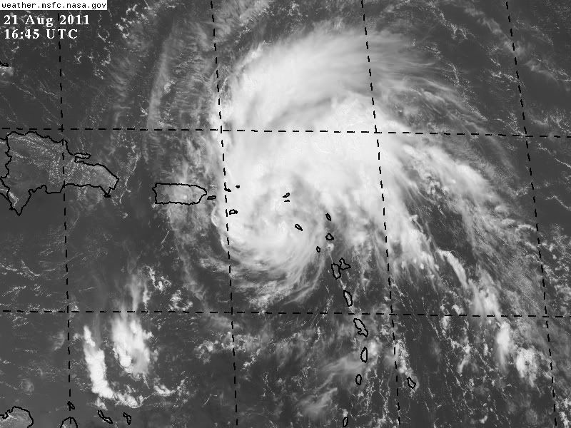
Still looking better and better (more organized) every frame.
live loop: http://wwwghcc.msfc.nasa.gov/cgi-bin/ge ... mframes=10
live loop: http://wwwghcc.msfc.nasa.gov/cgi-bin/ge ... mframes=10
0 likes
M a r k
- - - - -
Join us in chat: Storm2K Chatroom Invite. Android and IOS apps also available.
The posts in this forum are NOT official forecasts and should not be used as such. Posts are NOT endorsed by any professional institution or STORM2K.org. For official information and forecasts, please refer to NHC and NWS products.
- - - - -
Join us in chat: Storm2K Chatroom Invite. Android and IOS apps also available.
The posts in this forum are NOT official forecasts and should not be used as such. Posts are NOT endorsed by any professional institution or STORM2K.org. For official information and forecasts, please refer to NHC and NWS products.
-
Dave
- Retired Staff
- Posts: 13442
- Age: 75
- Joined: Tue Aug 01, 2006 3:57 pm
- Location: Milan Indiana
- Contact:
Next mission:
FLIGHT TWO -- TEAL 73
A. 22/0000Z,0600Z
B. AFXXX 0309A CYCLONE
C. 21/2300Z
D. 16.5N 65.00W
E. 21/2330Z TO 21/0600Z
F. SFC TO 10,000 FT
FLIGHT TWO -- TEAL 73
A. 22/0000Z,0600Z
B. AFXXX 0309A CYCLONE
C. 21/2300Z
D. 16.5N 65.00W
E. 21/2330Z TO 21/0600Z
F. SFC TO 10,000 FT
0 likes
This post is NOT AN OFFICIAL FORECAST and should not be used as such. It is just the opinion of the poster and may or may not be backed by sound meteorological data. It is NOT endorsed by any professional institution including storm2k.org. For Official Information please refer to the NHC and NWS products.
Re: ATL: IRENE - Tropical Storm - Discussion
tolakram wrote:Still looking better and better (more organized) every frame.
live loop: http://wwwghcc.msfc.nasa.gov/cgi-bin/ge ... mframes=10
Look closely at the donut core. Maybe the WSW wobble wasn't so crazy after all? May be an illusion, but worth noting. That would be a real coup if GFDL was on to something after all...
0 likes
-
brunota2003

- S2K Supporter

- Posts: 9476
- Age: 35
- Joined: Sat Jul 30, 2005 9:56 pm
- Location: Stanton, KY...formerly Havelock, NC
- Contact:

Re: ATL: IRENE - Tropical Storm - Discussion
ConvergenceZone wrote:I'm FAR more worried now then I was 12hrs ago. ts not going to take the track of last nights GFS with this center further north and instead going to emerge off Hispaniola avoiding Cuba...then it might have a stretch of 2-3 days heading N/NNW...and that my friend in the atmosphere progged is good enough for a 3/4 landfalling hurricane...
KWT, but wouldn't the NHC have it as a major then instead of only a cat 1 hitting Florida? I would think they would want to error on the side of caution, but there must be something they are seeing which is why they are keeping it at a cat 1 only.
Because it takesd a different track to what is being suggested by some of the models now, the other models give it far more time over water then the NHC track. Combined with the NHC being well known to be a little on the conservative side, and there you have the risk of a strong hurricane.
0 likes
Personal Forecast Disclaimer:
The posts in this forum are NOT official forecast and should not be used as such. They are just the opinion of the poster and may or may not be backed by sound meteorological data. They are NOT endorsed by any professional institution or storm2k.org. For official information, please refer to the NHC and NWS products
The posts in this forum are NOT official forecast and should not be used as such. They are just the opinion of the poster and may or may not be backed by sound meteorological data. They are NOT endorsed by any professional institution or storm2k.org. For official information, please refer to the NHC and NWS products
-
blazess556
- Professional-Met

- Posts: 250
- Joined: Mon Aug 31, 2009 10:51 pm
- Location: Germantown, MD
Who is online
Users browsing this forum: No registered users and 23 guests