ATL: IRENE - Models

Moderator: S2k Moderators

Message
Author
User avatar
Ivanhater
Storm2k Moderator
Storm2k Moderator
Posts: 11162
Age: 38
Joined: Fri Jul 01, 2005 8:25 am
Location: Pensacola

Re: ATL: IRENE - Models

#1761 Postby Ivanhater » Sat Aug 20, 2011 7:03 pm

GFDL...SOUTH of Western Cuba and STRONG :eek:

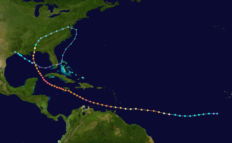
HOUR: .0 LONG: -57.22 LAT: 14.44 MIN PRESS (hPa): 1004.85 MAX SURF WIND (KNOTS): 40.10
HOUR: 6.0 LONG: -58.80 LAT: 14.84 MIN PRESS (hPa): 1001.67 MAX SURF WIND (KNOTS): 54.43
HOUR: 12.0 LONG: -60.77 LAT: 15.33 MIN PRESS (hPa): 1000.36 MAX SURF WIND (KNOTS): 53.31
HOUR: 18.0 LONG: -62.88 LAT: 15.81 MIN PRESS (hPa): 997.82 MAX SURF WIND (KNOTS): 54.20
HOUR: 24.0 LONG: -64.59 LAT: 16.30 MIN PRESS (hPa): 993.60 MAX SURF WIND (KNOTS): 62.83
HOUR: 30.0 LONG: -66.30 LAT: 16.61 MIN PRESS (hPa): 985.96 MAX SURF WIND (KNOTS): 76.30
HOUR: 36.0 LONG: -67.87 LAT: 16.79 MIN PRESS (hPa): 978.74 MAX SURF WIND (KNOTS): 82.12
HOUR: 42.0 LONG: -69.46 LAT: 16.94 MIN PRESS (hPa): 971.33 MAX SURF WIND (KNOTS): 89.53
HOUR: 48.0 LONG: -70.92 LAT: 17.15 MIN PRESS (hPa): 961.33 MAX SURF WIND (KNOTS):106.45
HOUR: 54.0 LONG: -72.28 LAT: 17.35 MIN PRESS (hPa): 954.60 MAX SURF WIND (KNOTS):104.04
HOUR: 60.0 LONG: -73.64 LAT: 17.58 MIN PRESS (hPa): 952.33 MAX SURF WIND (KNOTS):107.73
HOUR: 66.0 LONG: -74.86 LAT: 17.79 MIN PRESS (hPa): 948.83 MAX SURF WIND (KNOTS):107.80
HOUR: 72.0 LONG: -75.95 LAT: 17.88 MIN PRESS (hPa): 942.23 MAX SURF WIND (KNOTS):114.43
HOUR: 78.0 LONG: -76.92 LAT: 17.87 MIN PRESS (hPa): 941.82 MAX SURF WIND (KNOTS):109.23
HOUR: 84.0 LONG: -78.01 LAT: 18.01 MIN PRESS (hPa): 948.03 MAX SURF WIND (KNOTS):107.60
HOUR: 90.0 LONG: -79.00 LAT: 18.25 MIN PRESS (hPa): 945.67 MAX SURF WIND (KNOTS):113.95
HOUR: 96.0 LONG: -79.93 LAT: 18.54 MIN PRESS (hPa): 942.10 MAX SURF WIND (KNOTS):118.59
HOUR:102.0 LONG: -80.70 LAT: 18.88 MIN PRESS (hPa): 931.85 MAX SURF WIND (KNOTS):125.30
HOUR:108.0 LONG: -81.63 LAT: 19.38 MIN PRESS (hPa): 929.82 MAX SURF WIND (KNOTS):124.06
HOUR:114.0 LONG: -82.53 LAT: 19.98 MIN PRESS (hPa): 928.34 MAX SURF WIND (KNOTS):124.96
HOUR:120.0 LONG: -83.46 LAT: 20.66 MIN PRESS (hPa): 924.56 MAX SURF WIND (KNOTS):132.89
HOUR:126.0 LONG: -84.50 LAT: 21.32 MIN PRESS (hPa): 920.99 MAX SURF WIND (KNOTS):133.46
0 likes   
Michael

psyclone
S2K Supporter
S2K Supporter
Posts: 4769
Joined: Wed Aug 24, 2005 9:04 pm
Location: palm harbor fl

#1762 Postby psyclone » Sat Aug 20, 2011 7:03 pm

Ivan's example track is exactly what i've been thinking as well although in an earlier post this morning i said dennis (2005) but farther east. that rare panama city/apalachicola/st george island hit wouldn't surprise me at all. should such an event occur, even if the storm isn't strong...if the windfield is big there could be quite a water rise in the big bend area. recall that st marks was inundated with 10 feet of water when dennis hit the western panhandle!

The posts in this forum are NOT official forecast and should not be used as such. They are just the opinion of the poster and may or may not be backed by sound meteorological data. They are NOT endorsed by any professional institution or storm2k.org. For official information, please refer to the NHC and NWS products.
0 likes   

User avatar
Ivanhater
Storm2k Moderator
Storm2k Moderator
Posts: 11162
Age: 38
Joined: Fri Jul 01, 2005 8:25 am
Location: Pensacola

Re: ATL: IRENE - Models

#1763 Postby Ivanhater » Sat Aug 20, 2011 7:06 pm

GFDL through the Yucatan channel close to UKMET and Canadian :eek:
0 likes   
Michael

User avatar
Ivanhater
Storm2k Moderator
Storm2k Moderator
Posts: 11162
Age: 38
Joined: Fri Jul 01, 2005 8:25 am
Location: Pensacola

Re: ATL: IRENE - Models

#1764 Postby Ivanhater » Sat Aug 20, 2011 7:06 pm

Image
0 likes   
Michael

indian
Tropical Low
Tropical Low
Posts: 38
Joined: Wed Jul 27, 2011 5:15 pm

Re: ATL: IRENE - Models

#1765 Postby indian » Sat Aug 20, 2011 7:08 pm

Ivanhater wrote:Image


more of a westerly path if i am looking at that correctly
0 likes   

User avatar
AtlanticWind
S2K Supporter
S2K Supporter
Posts: 1891
Age: 66
Joined: Sun Aug 08, 2004 9:57 pm
Location: Plantation,Fla

Re: ATL: IRENE - Models

#1766 Postby AtlanticWind » Sat Aug 20, 2011 7:08 pm

Ivanhater wrote:GFDL through the Yucatan channel close to UKMET and Canadian :eek:

For 6 straight runs it shows nothing ,then it bombs it out and moves it west? What has happened to the GFDL?
0 likes   

tolakram
Admin
Admin
Posts: 20012
Age: 62
Joined: Sun Aug 27, 2006 8:23 pm
Location: Florence, KY (name is Mark)

Re: ATL: IRENE - Models

#1767 Postby tolakram » Sat Aug 20, 2011 7:08 pm

Good grief, but does that include any of the recent recon data?
0 likes   
M a r k
- - - - -
Join us in chat: Storm2K Chatroom Invite. Android and IOS apps also available.

The posts in this forum are NOT official forecasts and should not be used as such. Posts are NOT endorsed by any professional institution or STORM2K.org. For official information and forecasts, please refer to NHC and NWS products.

User avatar
SouthDadeFish
Professional-Met
Professional-Met
Posts: 2835
Joined: Thu Sep 23, 2010 2:54 pm
Location: Miami, FL
Contact:

#1768 Postby SouthDadeFish » Sat Aug 20, 2011 7:08 pm

:uarrow: Let's just say if the 18Z GFDL verifies.... It wouldn't be good.
0 likes   

jinftl
Category 5
Category 5
Posts: 4312
Joined: Tue Aug 31, 2004 4:47 pm
Location: fort lauderdale, fl

Re:

#1769 Postby jinftl » Sat Aug 20, 2011 7:09 pm

Irene is a good 200 miles north of where Ivan was at the same longitude. That is significant, esp with a trough expected to impact the storm in some way...not to mention landmasses that could rip her apart.

Irene is at 14.9N 58.5W, compared to:

AT 5 AM AST...0900Z...THE CENTER OF HURRICANE IVAN WAS LOCATED NEAR
LATITUDE 11.4 NORTH...LONGITUDE 58.5 WEST OR ABOUT 140 MILES...
230 KM...SOUTH-SOUTHEAST OF BARBADOS. THIS IS ALSO ABOUT 140
MILES...225 KM...EAST OF TOBAGO.


psyclone wrote:Ivan's example track is exactly what i've been thinking as well although in an earlier post this morning i said dennis (2005) but farther east. that rare panama city/apalachicola/st george island hit wouldn't surprise me at all. should such an event occur, even if the storm isn't strong...if the windfield is big there could be quite a water rise in the big bend area. recall that st marks was inundated with 10 feet of water when dennis hit the western panhandle!

The posts in this forum are NOT official forecast and should not be used as such. They are just the opinion of the poster and may or may not be backed by sound meteorological data. They are NOT endorsed by any professional institution or storm2k.org. For official information, please refer to the NHC and NWS products.
0 likes   

User avatar
Ivanhater
Storm2k Moderator
Storm2k Moderator
Posts: 11162
Age: 38
Joined: Fri Jul 01, 2005 8:25 am
Location: Pensacola

Re: ATL: IRENE - Models

#1770 Postby Ivanhater » Sat Aug 20, 2011 7:09 pm

GFDL is almost an exact track of Ivan :ggreen:
0 likes   
Michael

Aric Dunn
Category 5
Category 5
Posts: 21238
Age: 42
Joined: Sun Sep 19, 2004 9:58 pm
Location: Ready for the Chase.
Contact:

Re: ATL: IRENE - Models

#1771 Postby Aric Dunn » Sat Aug 20, 2011 7:12 pm

Ivanhater wrote:GFDL is almost an exact track of Ivan :ggreen:


and you came to that conclusion how ? lol

Image
0 likes   
Note: If I make a post that is brief. Please refer back to previous posts for the analysis or reasoning. I do not re-write/qoute what my initial post said each time.
If there is nothing before... then just ask :)

Space & Atmospheric Physicist, Embry-Riddle Aeronautical University,
I believe the sky is falling...

User avatar
red herring
Tropical Low
Tropical Low
Posts: 18
Joined: Fri Jul 22, 2011 11:28 am
Location: Victoria, TX

Re: ATL: IRENE - Models

#1772 Postby red herring » Sat Aug 20, 2011 7:12 pm

wzrgirl1 wrote:
indian wrote:i still think there is a possibility of irene making it as far west as the upper texas coast


There is absolutely nothing that points in that direction and I think you may be trolling. Please stop.


The GFDL, UKMET, and Canadian point that way
0 likes   
Personal Forecast Disclaimer:
The posts in this forum are NOT official forecast and should not be used as such. They are just the opinion of the poster and may or may not be backed by sound meteorological data. They are NOT endorsed by any professional institution or storm2k.org. For official information, please refer to the NHC and NWS products

User avatar
Tampa_God
Category 1
Category 1
Posts: 333
Age: 35
Joined: Wed May 31, 2006 7:27 pm
Location: New Port Richey/Trinity, FL

Re: ATL: IRENE - Models

#1773 Postby Tampa_God » Sat Aug 20, 2011 7:13 pm

Ivanhater wrote:GFDL is almost an exact track of Ivan :ggreen:

Exactly the same thing I said when I saw the track.
0 likes   

BigB0882
S2K Supporter
S2K Supporter
Posts: 2284
Joined: Thu Jul 03, 2003 12:08 am
Location: Baton Rouge, LA
Contact:

#1774 Postby BigB0882 » Sat Aug 20, 2011 7:13 pm

Is this the first time GFDL has developed it? Wasn't it leaving it as an open wave for a long time?
0 likes   

User avatar
gatorcane
S2K Supporter
S2K Supporter
Posts: 23692
Age: 47
Joined: Sun Mar 13, 2005 3:54 pm
Location: Boca Raton, FL

Re:

#1775 Postby gatorcane » Sat Aug 20, 2011 7:13 pm

SouthDadeFish wrote::uarrow: Let's just say if the 18Z GFDL verifies.... It wouldn't be good.


Considering the GFDL didn't even pick up on the system for the past 4 or 5 runs, I would be highly suspect of the GFDL right now and treat it as an outlier. Let's see what the HWRF does.
Last edited by gatorcane on Sat Aug 20, 2011 7:13 pm, edited 1 time in total.
0 likes   

User avatar
Ivanhater
Storm2k Moderator
Storm2k Moderator
Posts: 11162
Age: 38
Joined: Fri Jul 01, 2005 8:25 am
Location: Pensacola

Re: ATL: IRENE - Models

#1776 Postby Ivanhater » Sat Aug 20, 2011 7:13 pm

As far as skirting to the south of Jamaica and to the Yucatan
0 likes   
Michael

indian
Tropical Low
Tropical Low
Posts: 38
Joined: Wed Jul 27, 2011 5:15 pm

Re: ATL: IRENE - Models

#1777 Postby indian » Sat Aug 20, 2011 7:14 pm

red herring wrote:
wzrgirl1 wrote:
indian wrote:i still think there is a possibility of irene making it as far west as the upper texas coast


There is absolutely nothing that points in that direction and I think you may be trolling. Please stop.


The GFDL, UKMET, and Canadian point that way


thank you!!!! :wink:
0 likes   

User avatar
thundercam96
Tropical Storm
Tropical Storm
Posts: 129
Joined: Thu Aug 18, 2011 3:01 pm
Location: Boston, MA

Re: ATL: IRENE - Models

#1778 Postby thundercam96 » Sat Aug 20, 2011 7:14 pm

Ivanhater wrote:Image

At the very end, what is the wind speed?
0 likes   
Fay '08 / Mathew 16'

Personal Forecast Disclaimer: I am not a certified meteorologist, therefore, what is posted on this forum under my header should not be treated as an official forecast. Please refer to the NWS/NHC products for forecast information.

User avatar
ronjon
Category 5
Category 5
Posts: 4823
Joined: Fri Aug 19, 2005 5:17 pm
Location: Hernando Beach, FL

Re: ATL: IRENE - Models

#1779 Postby ronjon » Sat Aug 20, 2011 7:14 pm

That GFDL run is even outside of the cone of the NHC - might want to wait till the 00z run.
0 likes   

User avatar
KWT
Category 5
Category 5
Posts: 31415
Joined: Tue Aug 17, 2004 11:02 am
Location: UK!!!

#1780 Postby KWT » Sat Aug 20, 2011 7:14 pm

Wow that GFDL is nuts, goes down to something like 920mbs!! :eek:

Still, the models show a VERY favourable set-up aloft, given the amount of land interaction GFS/ECM show and still having it as a hurricane by landfall is ringing big alarm bells!
0 likes   
Personal Forecast Disclaimer:
The posts in this forum are NOT official forecast and should not be used as such. They are just the opinion of the poster and may or may not be backed by sound meteorological data. They are NOT endorsed by any professional institution or storm2k.org. For official information, please refer to the NHC and NWS products


Return to “2011”

Who is online

Users browsing this forum: No registered users and 14 guests