
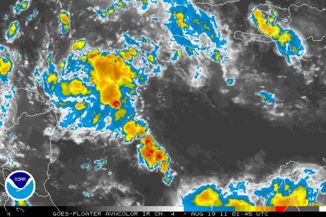
West Cuba fired off some very heavy afternoon thunderstorms and the debris looks to be rotating into the ML dry air to 93L's east.
http://www.ssd.noaa.gov/goes/east/watl/flash-wv.html
This could be the shot 93L needed.
Might have a nicely ramping up TC by sunrise.
ATL : HARVEY - Tropical Depression - Discussion
Moderator: S2k Moderators
-
ozonepete
- Professional-Met

- Posts: 4743
- Joined: Mon Sep 07, 2009 3:23 pm
- Location: From Ozone Park, NYC / Now in Brooklyn, NY
Re: ATL : INVEST 93L - Discussion
0 likes
-
ozonepete
- Professional-Met
- Posts: 4743
- Joined: Mon Sep 07, 2009 3:23 pm
- Location: From Ozone Park, NYC / Now in Brooklyn, NY
Re: ATL : INVEST 93L - Discussion
BTW, it was that (what appears to be) developing TUTT to the north and northeast of 93L that pushed the moisture southward towards its northern and eastern sides. And a TUTT to the northeast of a developing cyclone is advantageous for development because it helps vent the system at upper levels on the northeast side and thus helps an upper level anti-cyclone to develop.
0 likes
Re: ATL : INVEST 93L - Discussion
ozonepete wrote::uarrow: Nice observation. You're becoming the maven here on mid-level moisture. It's amazing how many times people miss that key element for formation and survival of a TC. (Including myself too often.)
Thanks Phil
0 likes

Re: ATL : INVEST 93L - Discussion
Looks to me like it has gained enough latitude so that it will get over the "knee" of Honduras and Nicaragua, though if it is only 20-50 miles north it won't strengthen much. Still expect a TC out of this.
0 likes
Re: ATL : INVEST 93L - Discussion
ozonepete wrote:BTW, it was that (what appears to be) developing TUTT to the north and northeast of 93L that pushed the moisture southward towards its northern and eastern sides. And a TUTT to the northeast of a developing cyclone is advantageous for development because it helps vent the system at upper levels on the northeast side and thus helps an upper level anti-cyclone to develop.
Agreed.
Also when a TC tracks into an anti-cyclone it allows the vorticity column to expand vertically since an anti-cyclone is a localized rise in the tropopause.
That in turn pulls the vorticity (PV anomaly) in radially causing the angular rotation to increase due to conservation of angular momentum.
The old spinning skater pulling his arms in analogy.
Anyway, that is in fact what appears to be happening with 93L at this time.
0 likes
-
Brent
- S2K Supporter

- Posts: 38745
- Age: 37
- Joined: Sun May 16, 2004 10:30 pm
- Location: Tulsa Oklahoma
- Contact:
Re: ATL : INVEST 93L - Discussion
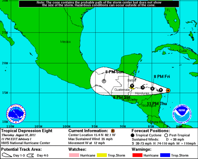
BEST TRACK: AL08, 154N 815W, 30kts, 1006mb, TD EIGHT
RENUMBER al93 al08
RENUMBER al93 al08
0 likes
#neversummer
Re: ATL : INVEST 93L - Discussion
Finally! 
Getting a hot-tower firing. Its small and only lasted about 1/2 hr.; but, a solid sign 93L is ramping up.

Getting a hot-tower firing. Its small and only lasted about 1/2 hr.; but, a solid sign 93L is ramping up.
0 likes
-
ozonepete
- Professional-Met
- Posts: 4743
- Joined: Mon Sep 07, 2009 3:23 pm
- Location: From Ozone Park, NYC / Now in Brooklyn, NY
Re: ATL : INVEST 93L - Discussion
Yeah, finally. It has to be at least a TD. And Hondurans need to know about this.
Although it looks weak enough on the left semi-circle, which is climatologically what you expect, it still has the capability of causing dangerous rainfall and mudslides there.
Although it looks weak enough on the left semi-circle, which is climatologically what you expect, it still has the capability of causing dangerous rainfall and mudslides there.
0 likes
-
ozonepete
- Professional-Met
- Posts: 4743
- Joined: Mon Sep 07, 2009 3:23 pm
- Location: From Ozone Park, NYC / Now in Brooklyn, NY
Re: ATL : INVEST 93L - Discussion
Nice feeder band has developed, feeding moisture into the southeast quadrant.
0 likes

Re: ATL : INVEST 93L - Discussion
Now the question is whether it will get strong enough to get to Harvey or will remain an unnamed depression. Given the current latitude (15.4), the poor organization convectively speaking, and the fact that it isn't going to traverse much to the north, I will say that the chances are probably more likely than not that it will just stay TD Eight...just my opinion...not official. My guess is landfall by noon tomorrow.
0 likes
-
ozonepete
- Professional-Met
- Posts: 4743
- Joined: Mon Sep 07, 2009 3:23 pm
- Location: From Ozone Park, NYC / Now in Brooklyn, NY
Re: ATL : INVEST 93L - Discussion
With no shear to speak of, no mid-level dry air at all, the center staying north of Honduras, and it slowing down a lot over the next 24 hours, I would say a strong tropical storm close to a hurricane by the time it landfalls in Belize. The only negative is the proximity to land in Honduras, but the northwesterly winds pushing up against the mountains could actually enhance the circulation strength.
0 likes
-
ozonepete
- Professional-Met
- Posts: 4743
- Joined: Mon Sep 07, 2009 3:23 pm
- Location: From Ozone Park, NYC / Now in Brooklyn, NY
Re: ATL : INVEST 93L - Discussion
the big question is will it curve left into Honduras. That's why I'm dying to see the NHC track forecast.
0 likes
Re: ATL : INVEST 93L - Discussion
TROPICAL DEPRESSION EIGHT ADVISORY NUMBER 1
NWS NATIONAL HURRICANE CENTER MIAMI FL AL082011
1100 PM EDT THU AUG 18 2011
...TROPICAL DEPRESSION FORMS IN THE WESTERN CARIBBEAN SEA...
SUMMARY OF 1100 PM EDT...0300 UTC...INFORMATION
-----------------------------------------------
LOCATION...15.4N 82.1W
ABOUT 80 MI...125 KM ENE OF CABO GRACIAS A DIOS ON NIC/HON BORDER
ABOUT 430 MI...690 KM ESE OF BELIZE CITY
MAXIMUM SUSTAINED WINDS...35 MPH...55 KM/H
PRESENT MOVEMENT...W OR 270 DEGREES AT 12 MPH...19 KM/H
MINIMUM CENTRAL PRESSURE...1006 MB...29.71 INCHES
0 likes
-
wxman57

- Moderator-Pro Met

- Posts: 23174
- Age: 68
- Joined: Sat Jun 21, 2003 8:06 pm
- Location: Houston, TX (southwest)
Re: ATL : INVEST 93L - Discussion
It may be inland over Honduras by sunrise. NHC track has the center very near the coast of Honduras at 12Z. Could become a weak TS as it skirts along the coast of Honduras but that's about it.
0 likes
-
Tampa_God

- Category 1

- Posts: 333
- Age: 36
- Joined: Wed May 31, 2006 7:27 pm
- Location: New Port Richey/Trinity, FL
Re: ATL : EIGHT - Tropical Depression - Discussion
Min. Tropical Storm before slamming into Honduras/ South America? It's close, but it needs to get it's act together.
0 likes
-
cycloneye

- Admin

- Posts: 149429
- Age: 69
- Joined: Thu Oct 10, 2002 10:54 am
- Location: San Juan, Puerto Rico
Re: ATL : INVEST 93L - Discussion
ozonepete wrote:the big question is will it curve left into Honduras. That's why I'm dying to see the NHC track forecast.

0 likes
Visit the Caribbean-Central America Weather Thread where you can find at first post web cams,radars
and observations from Caribbean basin members Click Here
and observations from Caribbean basin members Click Here
Re: ATL : EIGHT - Tropical Depression - Discussion
Track takes it inland tomorrow morning...then slightly reemerges off that coastal area angles in a more southerly direction...may have a little time to become Harvey, but I think it's 50-50 at best...probably more 70-30 remains TD Eight in my opinion.
0 likes
-
ozonepete
- Professional-Met
- Posts: 4743
- Joined: Mon Sep 07, 2009 3:23 pm
- Location: From Ozone Park, NYC / Now in Brooklyn, NY
Re: ATL : EIGHT - Tropical Depression - Discussion
Interesting. It makes TS after landfall. LOL.
0 likes
Who is online
Users browsing this forum: No registered users and 12 guests