ATL: BRET - Remnants - Discussion
Moderator: S2k Moderators

Re: ATL: INVEST 98L - Discussion
Latest MLB radar shows rainfall just north of Grand Bahama and Great Abaco

Looking at radar loop...slow drift south/hardly moving?
http://radar.weather.gov/radar.php?rid= ... 1&loop=yes
Looking at radar loop...slow drift south/hardly moving?
http://radar.weather.gov/radar.php?rid= ... 1&loop=yes
0 likes
-
cycloneye

- Admin

- Posts: 149425
- Age: 69
- Joined: Thu Oct 10, 2002 10:54 am
- Location: San Juan, Puerto Rico
Re: ATL: INVEST 98L - Recon
If all goes as planned,the plane departs around 12:15 PM EDT and arrives at the system around 1:30 PM - 2 PM timeframe.But,until the plane is in the air, is not a stone thing that they fly,because the system may weaken suddenly in the next few hours and then the flight is cancelled.
0 likes
Visit the Caribbean-Central America Weather Thread where you can find at first post web cams,radars
and observations from Caribbean basin members Click Here
and observations from Caribbean basin members Click Here
once we get a fix from recon and initialized by the models on the 00z package may clear up some if the ambuguity...Regarless, the synoptic set this isnt going anywhere fast over the next 48....Do think its reasonable it makes it to at least a portion of the coast between melbourne and west palm.....
0 likes
-
Aric Dunn
- Category 5

- Posts: 21238
- Age: 43
- Joined: Sun Sep 19, 2004 9:58 pm
- Location: Ready for the Chase.
- Contact:
Re:
Vortex wrote:once we get a fix from recon and initialized by the models on the 00z package may clear up some if the ambuguity...Regarless, the synoptic set this isnt going anywhere fast over the next 48....Do think its reasonable it makes it to at least a portion of the coast between melbourne and west palm.....
sounds about right
0 likes
Note: If I make a post that is brief. Please refer back to previous posts for the analysis or reasoning. I do not re-write/qoute what my initial post said each time.
If there is nothing before... then just ask
Space & Atmospheric Physicist, Embry-Riddle Aeronautical University,
I believe the sky is falling...
If there is nothing before... then just ask
Space & Atmospheric Physicist, Embry-Riddle Aeronautical University,
I believe the sky is falling...

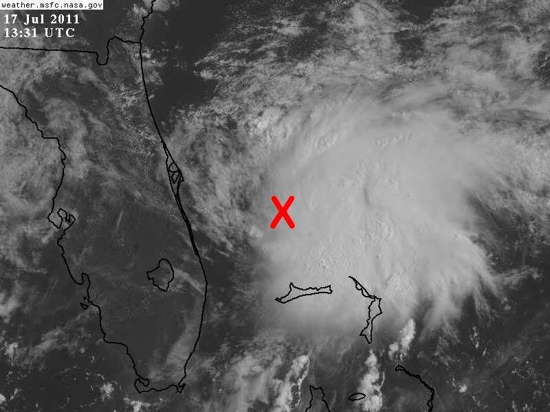
This radar picture I centered it based on the latest best track coordinates of 98L, as you can see the surface low center is dislocated to the northwest of its mid level circulation. NW mid level shear is still affecting the system.
Click here for radar loop of the image above
Click here for radar loop of the image above
Last edited by NDG on Sun Jul 17, 2011 8:24 am, edited 1 time in total.
0 likes
Re:
NDG wrote:This radar picture I centered it based on the latest best track coordinates of 98L, as you can see the surface low center is dislocated to the northwest of its mid level circulation. NW mid level shear is still affecting the system.
http://i20.photobucket.com/albums/b245/ ... -78835.gif
Click here for radar loop of the image above
Agree, still loosly defined but latest vis indicates UL winds aloft may be slowly relaxing and wouldnt surprise me abit if it tightens up under the deeper convection....
0 likes
Re: ATL: INVEST 98L - Discussion
The further south the system gets in the short-term, the lower the shear?

0 likes
-
Blown Away

- S2K Supporter

- Posts: 10253
- Joined: Wed May 26, 2004 6:17 am
Re: ATL: INVEST 98L - Discussion
The NW shear is still evident and IMO the 30% chance of development is appropriate for this area. How many of these lows have developed into a TD off the Central Florida coast and moved S'ward? Not many.
0 likes
Hurricane Eye Experience: David 79, Irene 99, Frances 04, Jeanne 04, Wilma 05… Hurricane Brush Experience: Andrew 92, Erin 95, Floyd 99, Matthew 16, Irma 17, Ian 22, Nicole 22…

Re: ATL: INVEST 98L - Discussion
Well, well what a surprise I find this morning -- a 30% blob off Florida. Doesn't appear this will be a major threat but will it be a rainmaker for south FL?
snip from KW discussion
snip from KW discussion
THE ECMWF AND
PARTICULARLY THE NAM ARE MORE AGGRESSIVE...BRINGING THE LOWER LEVEL
CIRCULATION AND EVEN A WEAK SURFACE LOW ACROSS SOUTH FLORIDA AND
INTO THE SOUTHEASTERN GULF TONIGHT AND MONDAY. MEANWHILE..THE GFS
KEEPS A WEAKER FEATURE BETWEEN CENTRAL/SOUTH FLORIDA AND THE BAHAMAS
THROUGH TONIGHT...THEN WASHES IT OUT NEAR SOUTH FLORIDA ON MONDAY.
UNCERTAINTY IS QUITE HIGH WITH THIS FEATURE...WHICH IS BEING
MONITORED BY THE NATIONAL HURRICANE CENTER BUT CURRENTLY HAS ONLY A
LOW CHANCE FOR FURTHER DEVELOPMENT DURING THE NEXT 48 HOURS. WILL
FAVOR THE WEAKER GFS FOR THIS FORECAST PACKAGE...IN LINE WITH THE
LATEST MODEL DIAGNOSTIC DISCUSSION.
TODAY AND TONIGHT...ANY DIRECT IMPACTS FROM THE LOW PRESSURE TROUGH
OFF THE FLORIDA EAST COAST SHOULD REMAIN NORTH OF THE KEYS DURING
THIS TIME. WE COULD SEE INDIRECT EFFECTS HOWEVER...AS A BACKING STEERING
FLOW ALONG WITH A BIT MORE MID LEVEL MOISTURE SHOULD ALLOW FOR BETTER
CONVECTIVE COVERAGE ALONG OUTFLOW BOUNDARIES COMING OFF THE MAINLAND
DURING THE LATE AFTERNOON AND EVENING HOURS. THERE COULD BE SOME
CHANCE FOR A LATE CLOUD LINE ALONG THE KEYS AS WELL. WILL BRING
SCATTERED COVERAGE INTO THE BAY/GULF WATERS THIS AFTERNOON...AND
BUMP POPS UP TO 30 PERCENT FOR THE KEYS AS WELL THIS EVENING
0 likes


-
AdamFirst

- S2K Supporter
- Posts: 2490
- Age: 36
- Joined: Thu Aug 14, 2008 10:54 am
- Location: Port Saint Lucie, FL
Re: ATL: INVEST 98L - Discussion
Oh look....a drought buster just 100 miles to the east. Are you planning to drift our way, 98L, or are you gonna just wave from a distance and take off somewhere else?
0 likes
Dolphins Marlins Canes Golden Panthers HEAT
Andrew 1992 - Irene 1999 - Frances 2004 - Jeanne 2004 - Wilma 2005 - Fay 2008 - Isaac 2012 - Matthew 2016 - Irma 2017 - Dorian 2019 - Ian 2022 - Nicole 2022 - Milton 2024
Andrew 1992 - Irene 1999 - Frances 2004 - Jeanne 2004 - Wilma 2005 - Fay 2008 - Isaac 2012 - Matthew 2016 - Irma 2017 - Dorian 2019 - Ian 2022 - Nicole 2022 - Milton 2024


-
Blown Away
- S2K Supporter
- Posts: 10253
- Joined: Wed May 26, 2004 6:17 am
Re: ATL: INVEST 98L - Discussion
AdamFirst wrote:Oh look....a drought buster just 100 miles to the east. Are you planning to drift our way, 98L, or are you gonna just wave from a distance and take off somewhere else?
LOL, you wouldn't know it with such a bright sunny morning along the Treasure Coast! Looking at the visible 98L does look like it is getting better organized.
0 likes
Hurricane Eye Experience: David 79, Irene 99, Frances 04, Jeanne 04, Wilma 05… Hurricane Brush Experience: Andrew 92, Erin 95, Floyd 99, Matthew 16, Irma 17, Ian 22, Nicole 22…


I would put a better getting organized low pressure center at or just below the 28th latitude, conservatively, if not a bit closer to the deep convection.
I am basing this per the latest sat loop and radar loop, but strong vorticity may still be strongest above the surface as we are still not seeing any really surface pressure drops in the area.
I am basing this per the latest sat loop and radar loop, but strong vorticity may still be strongest above the surface as we are still not seeing any really surface pressure drops in the area.
0 likes
-
AdamFirst
- S2K Supporter
- Posts: 2490
- Age: 36
- Joined: Thu Aug 14, 2008 10:54 am
- Location: Port Saint Lucie, FL
Re: ATL: INVEST 98L - Discussion
The long range Melbourne radar shows a very slow south-to-west drift.
0 likes
Dolphins Marlins Canes Golden Panthers HEAT
Andrew 1992 - Irene 1999 - Frances 2004 - Jeanne 2004 - Wilma 2005 - Fay 2008 - Isaac 2012 - Matthew 2016 - Irma 2017 - Dorian 2019 - Ian 2022 - Nicole 2022 - Milton 2024
Andrew 1992 - Irene 1999 - Frances 2004 - Jeanne 2004 - Wilma 2005 - Fay 2008 - Isaac 2012 - Matthew 2016 - Irma 2017 - Dorian 2019 - Ian 2022 - Nicole 2022 - Milton 2024
-
Aric Dunn
- Category 5
- Posts: 21238
- Age: 43
- Joined: Sun Sep 19, 2004 9:58 pm
- Location: Ready for the Chase.
- Contact:
Re:
NDG wrote:I would put a better getting organized low pressure center at or just below the 28th latitude, conservatively, if not a bit closer to the deep convection.
I am basing this per the latest sat loop and radar loop, but strong vorticity may still be strongest above the surface as we are still not seeing any really surface pressure drops in the area.
http://i20.photobucket.com/albums/b245/ ... o2j3Zb.jpg
Actually I was just about to post something similar. I have it approximately at 27.9 77.8
0 likes
Note: If I make a post that is brief. Please refer back to previous posts for the analysis or reasoning. I do not re-write/qoute what my initial post said each time.
If there is nothing before... then just ask
Space & Atmospheric Physicist, Embry-Riddle Aeronautical University,
I believe the sky is falling...
If there is nothing before... then just ask
Space & Atmospheric Physicist, Embry-Riddle Aeronautical University,
I believe the sky is falling...
Re: ATL: INVEST 98L - Discussion
Webcam out of Jupiter Inlet (northern Palm Beach county)....can almost start to see edge of the cirrus clouds off to the east and northeast...

0 likes
-
wxman57

- Moderator-Pro Met

- Posts: 23174
- Age: 68
- Joined: Sat Jun 21, 2003 8:06 pm
- Location: Houston, TX (southwest)
Re: ATL: INVEST 98L - Discussion
SFC obs and satellite indicate a TD has already formed. I fully expect an upgrade this afternoon. Not sure about track/intensity. Models didn't initialize it well. Could move west into the Gulf eventually, or it could track off to the northeast in a few days. Depending upon interaction with Florida, it could get stronger than initial intensity models indicate, as those models probably see the very strong shear up around 30 N that may not be impacting the smallish low. I'll be heading in to the office in a few hours to be there for the likely upgrade.
0 likes
Who is online
Users browsing this forum: No registered users and 9 guests