ATL: INVEST 94L - DISCUSSION

Moderator: S2k Moderators

Message
Author
User avatar
ROCK
Category 5
Category 5
Posts: 9254
Age: 53
Joined: Tue Aug 17, 2004 7:30 am
Location: Kemah, Texas

Re: ATL: INVEST 94L - DISCUSSION

#121 Postby ROCK » Sat Jun 04, 2011 1:28 am

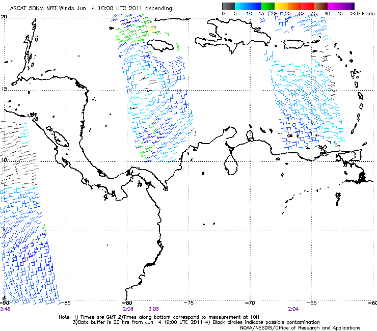
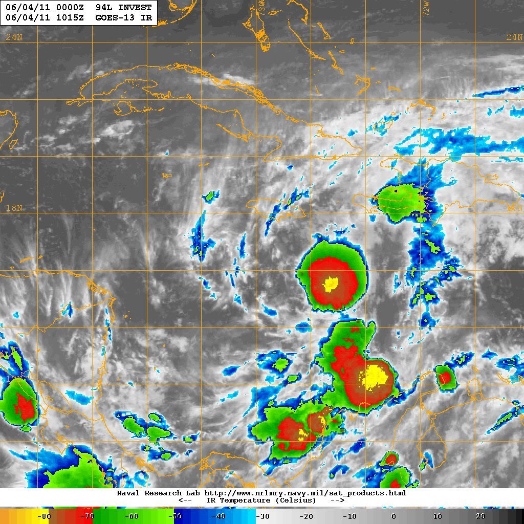
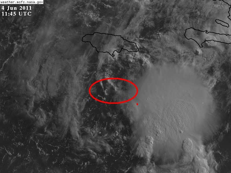
dwsqos2 wrote:Cloud tops have warmed in the last few hours. Low level convergence isn't that great. And what model support has it had for days? The good models have done little to nothing with it. I don't care about the CMC or NOGAPS. And please don't bring up the generally bad hurricane models.


Dws I forgot you were still around.... :lol: What about the CLIPPER now there is a good model to use.

Do we really need to go back in time to discuss old model runs. Its been sitting down there for a week...CMC has been tweaked and did exceptionally well in 2010.....hell yeah I am going to use it. Who wouldnt...... :roll:
0 likes   

User avatar
ROCK
Category 5
Category 5
Posts: 9254
Age: 53
Joined: Tue Aug 17, 2004 7:30 am
Location: Kemah, Texas

Re:

#122 Postby ROCK » Sat Jun 04, 2011 1:29 am

Weatherfreak000 wrote:2011 starting off bigtime IMO. I am getting this ominous feeling we may indeed see some dangerous tracks this season.


Shooting off the NE though? That's a strange track for June 3rd...


it is a strange track but it also means this death ridge will break down and allow for some sea breeze showers..thats what I am hoping for...
0 likes   

WeatherGuesser
Category 5
Category 5
Posts: 2672
Joined: Tue Jun 29, 2010 6:46 am

#123 Postby WeatherGuesser » Sat Jun 04, 2011 1:35 am

I'm guessing that the percentage will increase in the next TWO.

I'm not too sure it will. Maybe 40%,


Guess not. :roll:
0 likes   

Migle
Tropical Storm
Tropical Storm
Posts: 203
Age: 42
Joined: Fri Aug 27, 2010 5:30 pm
Location: New Orleans

Re: ATL: INVEST 94L - DISCUSSION

#124 Postby Migle » Sat Jun 04, 2011 3:45 am

Ouch

Image

Image
0 likes   

User avatar
caribepr
Category 5
Category 5
Posts: 1794
Joined: Fri Sep 05, 2003 10:43 pm
Location: Culebra, PR 18.33 65.33

#125 Postby caribepr » Sat Jun 04, 2011 5:05 am

Watching and waiting...humidity around here has been in the 95 to 99% range for days; move it, 94!
0 likes   

User avatar
KWT
Category 5
Category 5
Posts: 31391
Joined: Tue Aug 17, 2004 11:02 am
Location: UK!!!

#126 Postby KWT » Sat Jun 04, 2011 5:05 am

Convection has really weakened over the last few hours, a decent burst still developing further east but probably not as advanced as some think...
0 likes   
Personal Forecast Disclaimer:
The posts in this forum are NOT official forecast and should not be used as such. They are just the opinion of the poster and may or may not be backed by sound meteorological data. They are NOT endorsed by any professional institution or storm2k.org. For official information, please refer to the NHC and NWS products

User avatar
ronjon
Category 5
Category 5
Posts: 4672
Joined: Fri Aug 19, 2005 5:17 pm
Location: Hernando Beach, FL

Re: ATL: INVEST 94L - MODELS

#127 Postby ronjon » Sat Jun 04, 2011 5:40 am

Models that develop 94L quickly shoot it out to the NE into a weakness in the SW Atlantic. The weaker, broad low pressure envisoned by the GFS, Euro, GFDL, & NOGAPs drift the system slowly N-NW or NW into the Yuc straits or western Cuba. The weaker solution seems more accurate as of now. There is a mid or upper level low seen in the Euro over the western GOM which may help steer the mess into FL or the eastern GOM. It will probably also shear this thing to death.
Last edited by ronjon on Sat Jun 04, 2011 5:48 am, edited 1 time in total.
0 likes   

User avatar
KWT
Category 5
Category 5
Posts: 31391
Joined: Tue Aug 17, 2004 11:02 am
Location: UK!!!

#128 Postby KWT » Sat Jun 04, 2011 5:46 am

Yeah exactly, the more agressive solutions have the system shooting off to the NNE/NE.

Will have to see how the system evolves in the next few days.
0 likes   
Personal Forecast Disclaimer:
The posts in this forum are NOT official forecast and should not be used as such. They are just the opinion of the poster and may or may not be backed by sound meteorological data. They are NOT endorsed by any professional institution or storm2k.org. For official information, please refer to the NHC and NWS products

User avatar
srainhoutx
S2K Supporter
S2K Supporter
Posts: 6919
Age: 66
Joined: Sun Jan 14, 2007 11:34 am
Location: Haywood County, NC
Contact:

Re: ATL: INVEST 94L - DISCUSSION

#129 Postby srainhoutx » Sat Jun 04, 2011 5:48 am

94L is under some SW shear. Unless that changes later today and convection can begin to fire W of the circulation, I suspect RECON will be a no go.

Image

Image
0 likes   
Carla/Alicia/Jerry(In The Eye)/Michelle/Charley/Ivan/Dennis/Katrina/Rita/Wilma/Ike/Harvey

Member: National Weather Association
Wx Infinity Forums
http://wxinfinity.com/index.php

Facebook.com/WeatherInfinity
Twitter @WeatherInfinity

User avatar
ronjon
Category 5
Category 5
Posts: 4672
Joined: Fri Aug 19, 2005 5:17 pm
Location: Hernando Beach, FL

Re: ATL: INVEST 94L - MODELS

#130 Postby ronjon » Sat Jun 04, 2011 5:56 am

0 likes   

User avatar
wxman57
Moderator-Pro Met
Moderator-Pro Met
Posts: 22506
Age: 66
Joined: Sat Jun 21, 2003 8:06 pm
Location: Houston, TX (southwest)

Re: ATL: INVEST 94L - MODELS

#131 Postby wxman57 » Sat Jun 04, 2011 6:17 am


NOGAPS is hands-down THE worst tropical cyclone model on the planet. Whatever it says, I'd go 180 degrees from that. Taking a look at the overnight models, I see most just have it wandering around near Jamaica for 4-5 days then dissipating. That's probably most likely. Canadian, of course, develops it to a hurricane and tracks it NNE. There is a chance it could develop in a few days. If so, then it would probably track north to northeast as per the Canadian.
0 likes   

User avatar
wxman57
Moderator-Pro Met
Moderator-Pro Met
Posts: 22506
Age: 66
Joined: Sat Jun 21, 2003 8:06 pm
Location: Houston, TX (southwest)

Re: ATL: INVEST 94L - DISCUSSION

#132 Postby wxman57 » Sat Jun 04, 2011 6:24 am

I don't see much change since 12 hours ago. Pressures in the region aren't much lower. Winds around the weak low center still about 15-20 mph max. LLC is displaced about 100-120 miles west of that small blob of convection. Definitely doesn't qualify for TD upgrade at this time. There is very little model support for development now (except the Canadian). I won't even begin to touch the HWRF until it demonstrates it has a clue this year. Certainly didn't demonstrate that last year. And GFDL typically does poorly with intensity forecasts for such weak systems.

I'd revise its development potential to 30-40% based on everything I'm seeing. In most cases, such systems never get their acts together and develop.
0 likes   

User avatar
TheBurn
Category 2
Category 2
Posts: 524
Joined: Thu Jul 28, 2005 4:00 pm
Location: Rincon, PR

Re: ATL: INVEST 94L - DISCUSSION

#133 Postby TheBurn » Sat Jun 04, 2011 6:39 am

1115Z

Image

Image
0 likes   

User avatar
cycloneye
Admin
Admin
Posts: 139605
Age: 67
Joined: Thu Oct 10, 2002 10:54 am
Location: San Juan, Puerto Rico

Re: ATL: INVEST 94L - DISCUSSION

#134 Postby cycloneye » Sat Jun 04, 2011 6:42 am

06z Surface analysis:

Image

Uploaded by imageshack.us
0 likes   
Visit the Caribbean-Central America Weather Thread where you can find at first post web cams,radars
and observations from Caribbean basin members Click Here

User avatar
cycloneye
Admin
Admin
Posts: 139605
Age: 67
Joined: Thu Oct 10, 2002 10:54 am
Location: San Juan, Puerto Rico

Re: ATL: INVEST 94L - DISCUSSION

#135 Postby cycloneye » Sat Jun 04, 2011 6:46 am

Remains at 30% on the 8 AM TWO.

TROPICAL WEATHER OUTLOOK
NWS NATIONAL HURRICANE CENTER MIAMI FL
800 AM EDT SAT JUN 4 2011

FOR THE NORTH ATLANTIC...CARIBBEAN SEA AND THE GULF OF MEXICO...

A BROAD AREA OF LOW PRESSURE...CENTERED ABOUT 100 MILES SOUTH OF
JAMAICA...CONTINUES TO PRODUCE AN AREA OF SHOWERS AND THUNDERSTORMS
OVER THE WEST-CENTRAL CARIBBEAN SEA. UPPER-LEVEL WINDS ARE
EXPECTED TO BE CONDUCIVE FOR SOME DEVELOPMENT OF THIS SYSTEM OVER
THE NEXT COUPLE OF DAYS...AND THERE IS A MEDIUM CHANCE...30
PERCENT...OF TROPICAL CYCLONE FORMATION DURING THE NEXT 48 HOURS.
HEAVY RAINS COULD CAUSE FLASH FLOODING AND MUD SLIDES OVER PORTIONS
OF HAITI... THE DOMINICAN REPUBLIC...JAMAICA...AND EXTREME
SOUTHEASTERN CUBA OVER THE NEXT COUPLE OF DAYS AS THE LOW REMAINS
NEARLY STATIONARY.

ELSEWHERE...TROPICAL CYCLONE FORMATION IS NOT EXPECTED DURING THE
NEXT 48 HOURS.

$$
FORECASTER BERG

Image
0 likes   
Visit the Caribbean-Central America Weather Thread where you can find at first post web cams,radars
and observations from Caribbean basin members Click Here

User avatar
KWT
Category 5
Category 5
Posts: 31391
Joined: Tue Aug 17, 2004 11:02 am
Location: UK!!!

#136 Postby KWT » Sat Jun 04, 2011 7:20 am

30% seems a solid estimate, hasn't really developed much since last night as Wxman57 stated, indeed the convection is a little less impressive.
0 likes   
Personal Forecast Disclaimer:
The posts in this forum are NOT official forecast and should not be used as such. They are just the opinion of the poster and may or may not be backed by sound meteorological data. They are NOT endorsed by any professional institution or storm2k.org. For official information, please refer to the NHC and NWS products

User avatar
cycloneye
Admin
Admin
Posts: 139605
Age: 67
Joined: Thu Oct 10, 2002 10:54 am
Location: San Juan, Puerto Rico

Re: ATL: INVEST 94L - DISCUSSION

#137 Postby cycloneye » Sat Jun 04, 2011 7:29 am

Latest dvorak T numbers.

04/1145 UTC 15.9N 77.7W T1.0/1.0 94L -- Atlantic
0 likes   
Visit the Caribbean-Central America Weather Thread where you can find at first post web cams,radars
and observations from Caribbean basin members Click Here

User avatar
cycloneye
Admin
Admin
Posts: 139605
Age: 67
Joined: Thu Oct 10, 2002 10:54 am
Location: San Juan, Puerto Rico

Re: ATL: INVEST 94L - MODELS

#138 Postby cycloneye » Sat Jun 04, 2011 7:45 am

12z Bams:

Code: Select all

TROPICAL CYCLONE GUIDANCE MESSAGE
NWS NATIONAL HURRICANE CENTER MIAMI FL
1241 UTC SAT JUN 4 2011
 
DISCLAIMER...NUMERICAL MODELS ARE SUBJECT TO LARGE ERRORS.
PLEASE REFER TO NHC OFFICIAL FORECASTS FOR TROPICAL CYCLONE
AND SUBTROPICAL CYCLONE INFORMATION.
 
ATLANTIC OBJECTIVE AIDS FOR
 
DISTURBANCE INVEST (AL942011) 20110604 1200 UTC
 
        ...00 HRS...   ...12 HRS...   ...24 HRS. ..   ...36 HRS...
        110604  1200   110605  0000   110605  1200   110606  0000
 
         LAT    LON     LAT    LON     LAT    LON     LAT    LON
BAMS    16.2N  77.8W   16.8N  78.3W   17.2N  79.2W   17.5N  79.8W
BAMD    16.2N  77.8W   16.8N  77.9W   17.2N  78.2W   17.6N  78.7W
BAMM    16.2N  77.8W   16.7N  78.1W   17.0N  78.7W   17.4N  79.3W
LBAR    16.2N  77.8W   16.9N  77.8W   18.1N  77.5W   19.2N  76.5W
SHIP        25KTS          26KTS          28KTS          33KTS
DSHP        25KTS          26KTS          28KTS          33KTS
 
        ...48 HRS...   ...72 HRS...   ...96 HRS. ..   ..120 HRS...
        110606  1200   110607  1200   110608  1200   110609  1200
 
         LAT    LON     LAT    LON     LAT    LON     LAT    LON
BAMS    17.7N  80.4W   17.9N  81.4W   18.1N  82.9W   18.1N  83.5W
BAMD    18.2N  79.0W   20.4N  78.1W   23.9N  75.3W   27.9N  72.9W
BAMM    17.7N  79.7W   18.6N  80.0W   20.0N  80.2W   22.4N  79.8W
LBAR    20.6N  74.6W   23.5N  67.7W   31.3N  55.0W     .0N    .0W
SHIP        37KTS          42KTS          32KTS          20KTS
DSHP        37KTS          42KTS          32KTS          23KTS
 
         ...INITIAL CONDITIONS...
LATCUR =  16.2N LONCUR =  77.8W DIRCUR =   0DEG SPDCUR =   0KT
LATM12 =  16.3N LONM12 =  77.8W DIRM12 = 360DEG SPDM12 =   0KT
LATM24 =  16.0N LONM24 =  77.7W
WNDCUR =   25KT RMAXWD =  120NM WNDM12 =   25KT
CENPRS = 1007MB OUTPRS = 1010MB OUTRAD =  180NM SDEPTH =   M
RD34NE =    0NM RD34SE =    0NM RD34SW =    0NM RD34NW =   0NM


Image

Uploaded by imagkshack.us
0 likes   
Visit the Caribbean-Central America Weather Thread where you can find at first post web cams,radars
and observations from Caribbean basin members Click Here

User avatar
NDG
S2K Supporter
S2K Supporter
Posts: 14947
Joined: Sun Jul 09, 2006 10:14 pm
Location: Orlando, FL

Re: ATL: INVEST 94L - DISCUSSION

#139 Postby NDG » Sat Jun 04, 2011 7:51 am

And just that quick 94L is not that well organized this morning, with deepest convection east of a broad surface low. Like I thought last night, a mid level westerly shear must be affecting the system keeping the convection east of the center of circulation.
Hard to really find a true center with only a few daylight pictures to loop, it looks like the center is anywhere within the red circle I have drawn, so I giving the benefict of doubt.
But a naked swirl is very evident right on the left side of the red circle.
IMO, not unless convection gets going closer to the center of circulation I doubt that they will either send the recon or for the recon to find a TD, but a westerly wind is still evident, lol.

Image
0 likes   

User avatar
KWT
Category 5
Category 5
Posts: 31391
Joined: Tue Aug 17, 2004 11:02 am
Location: UK!!!

#140 Postby KWT » Sat Jun 04, 2011 7:54 am

Nope I probably wouldn't send recon into that system today, clearly at least 24hrs away from developing into a system that could get upgraded to a depression.
0 likes   
Personal Forecast Disclaimer:
The posts in this forum are NOT official forecast and should not be used as such. They are just the opinion of the poster and may or may not be backed by sound meteorological data. They are NOT endorsed by any professional institution or storm2k.org. For official information, please refer to the NHC and NWS products


Return to “2011”

Who is online

Users browsing this forum: No registered users and 4 guests