
MJO forecast from 8-13th
http://www.icess.ucsb.edu/asr/MJO_current_run.htm
ATL: Ex INVEST 92L - Discussion
Moderator: S2k Moderators
Re: ATL: INVEST 92L - Models
0 likes
-
maxintensity
- Tropical Storm

- Posts: 165
- Joined: Tue Aug 02, 2011 9:54 pm
Re: Re:
Unfortunately it is not that clear cut. According to NOAA, "Predicting where and when hurricanes will strike is related to daily weather patterns, which are not reliably predictable weeks or months in advance." It's impossible to say where 92L or any system after that will make final landfall. I'm hopeful the science will be there in the future, but until then, we can only speculate. I remember 5 days prior to landfall katrina was supposed to smash into florida and LA was not even in the cone of uncertainty. It was never supposed to cross 85W. 5 days later it killed over 1,000 people in LA with a direct strike. Needless to say, it's way too soon to know where 92L will go.wxman57 wrote:LaBreeze wrote:I just don't see a Katrina or Rita type of track with this hold that the High pressure has on us. It will be our saving grace from hurricanes and storms, but certainly not from the drought and heat!
Yep, I agree. If it reaches the NW Caribbean then a west track toward Mexico or perhaps the lower TX coast would be possible, but that ridge should hold firm over SE TX/LA/MS.
0 likes

Re: Re:
maxintensity wrote:Unfortunately it is not that clear cut. According to NOAA, "Predicting where and when hurricanes will strike is related to daily weather patterns, which are not reliably predictable weeks or months in advance." It's impossible to say where 92L or any system after that will make final landfall. I'm hopeful the science will be there in the future, but until then, we can only speculate. I remember 5 days prior to landfall katrina was supposed to smash into florida and LA was not even in the cone of uncertainty. It was never supposed to cross 85W. 5 days later it killed over 1,000 people in LA with a direct strike. Needless to say, it's way too soon to know where 92L will go.wxman57 wrote:LaBreeze wrote:I just don't see a Katrina or Rita type of track with this hold that the High pressure has on us. It will be our saving grace from hurricanes and storms, but certainly not from the drought and heat!
Yep, I agree. If it reaches the NW Caribbean then a west track toward Mexico or perhaps the lower TX coast would be possible, but that ridge should hold firm over SE TX/LA/MS.
You do realize you're telling this to a well respected professional meteorologist correct? I believe that I can safely say that there is no one that knows where this thing will go, but this is what the board is all about. Discussing potential storms....
0 likes
-
Kory
- Tropical Storm
- Posts: 200
- Age: 30
- Joined: Tue Aug 02, 2011 11:32 am
- Location: New Orleans, Louisiana
Re: Re:
ROCK wrote:wxman57 wrote:LaBreeze wrote:I just don't see a Katrina or Rita type of track with this hold that the High pressure has on us. It will be our saving grace from hurricanes and storms, but certainly not from the drought and heat!
Yep, I agree. If it reaches the NW Caribbean then a west track toward Mexico or perhaps the lower TX coast would be possible, but that ridge should hold firm over SE TX/LA/MS.
for 2 weeks this ridge is going to hold firm? we shall see....I have doubts...
If you haven't noticed that ridge has been there for at least a month or two. What do you think has kept Texas so dry and hot? Also there has been a persistent East Coast trough which would turn anything out to sea before it hits the United States. I see no signs of it moving, but remember if a strong storm finds even the smallest weakness in the ridge it will go northward.
The posts in this forum are NOT official forecast and should not be used as such. They are just the opinion of the poster and may or may not be backed by sound meteorological data. They are NOT endorsed by any professional institution or storm2k.org. For official information, please refer to the NHC and NWS products.
0 likes
-
cycloneye

- Admin

- Posts: 149426
- Age: 69
- Joined: Thu Oct 10, 2002 10:54 am
- Location: San Juan, Puerto Rico
Re: ATL: INVEST 92L - Discussion
8 AM TWD:
TROPICAL WAVE IS ANALYZED FROM 09N24W TO 18N22W MOVING W AT
10-15 KT. SHORTWAVE INFRARED METEOSAT-9 SATELLITE IMAGERY
REVEALS A BROAD LOW TO MID-LEVEL CYCLONIC CIRCULATION IN THE
VICINITY OF 11N23W...WHICH IS PRIMARILY A MONSOON TROUGH GYRE
ENCOMPASSING MOST OF THE EASTERN TROPICAL ATLC. THE WAVE IS
EMBEDDED IN AN AREA OF ENHANCED DEEP-LAYERED TOTAL PRECIPITABLE
WATER VALUES LOCATED SE OF THE CAPE VERDE ISLANDS WITH NO
SIGNIFICANT DEEP CONVECTION ASSOCIATED WITH THE WAVE...HOWEVER
SCATTERED MODERATE CONVECTION IS WITHIN 180 NM S OF THE MONSOON
TROUGH BETWEEN 20W-31W.
0 likes
Visit the Caribbean-Central America Weather Thread where you can find at first post web cams,radars
and observations from Caribbean basin members Click Here
and observations from Caribbean basin members Click Here
-
SETXPTNeches
- Tropical Low

- Posts: 26
- Age: 63
- Joined: Sun Jan 09, 2011 2:10 pm
- Location: Port Neches TX
Re: ATL: INVEST 92L - Discussion
That was going to be my question...how much longer is this High pressure ridge expected to stay in place and where do you find that info (in a graph)? I usually don't get too worried about TX until the end of August, middle of September...that seems to be the time that we really need to pay attention. This heat is brutal, though, need some relief, I am just afraid it will come in the form of something similar to Rita or Ike..
0 likes
PN-G Indians #1
Rita & Ike
The following post is NOT an official forecast and should not be used as such. It is just the opinion of the poster and may or may not be backed by sound meteorological data. It is NOT endorsed by any professional institution including storm2k.org For Official Information please refer to the NHC and NWS products.

Re: ATL: INVEST 92L - Models
If you don't mind. What does the MJO stand for?
0 likes
The preceding comments are never to be used as information to establish circumstances, plans or procedures for any weather related events. Only use official National Hurricane Center or National Weather Service information issued for your area.
-
wxman57

- Moderator-Pro Met

- Posts: 23174
- Age: 68
- Joined: Sat Jun 21, 2003 8:06 pm
- Location: Houston, TX (southwest)
Re: ATL: INVEST 92L - Discussion
Yes, the ridge has been sitting over the Southern Plains for 3 or more months, so there's no reason to think it will pack up and move out in the next 2 weeks. In fact, the GFS indicates the ridge will strengthen the 3rd week of August. The ridge should prevent movement of storms toward the upper TX coast eastward through Louisiana as long as it's in place. NE Gulf coast, FL, and the Carolinas are not protected, though.
0 likes
-
x-y-no

- Category 5

- Posts: 8359
- Age: 65
- Joined: Wed Aug 11, 2004 12:14 pm
- Location: Fort Lauderdale, FL
Re: ATL: INVEST 92L - Models
mutley wrote:
If you don't mind. What does the MJO stand for?
MJO is the Madden–Julian oscillation. It's a phenomenon which propagates west to east around the tropics and manifests as suppressed/enhanced tendency for convection and rainfall.
0 likes
Re: ATL: INVEST 92L - Models
x-y-no wrote:mutley wrote:
If you don't mind. What does the MJO stand for?
MJO is the Madden–Julian oscillation. It's a phenomenon which propagates west to east around the tropics and manifests as suppressed/enhanced tendency for convection and rainfall.
Thanks a lot. Learning so much here.
0 likes
The preceding comments are never to be used as information to establish circumstances, plans or procedures for any weather related events. Only use official National Hurricane Center or National Weather Service information issued for your area.

Re: ATL: INVEST 92L - Discussion
wxman57 wrote:Yes, the ridge has been sitting over the Southern Plains for 3 or more months, so there's no reason to think it will pack up and move out in the next 2 weeks. In fact, the GFS indicates the ridge will strengthen the 3rd week of August. The ridge should prevent movement of storms toward the upper TX coast eastward through Louisiana as long as it's in place. NE Gulf coast, FL, and the Carolinas are not protected, though.
Yeah I agree wxman57, I have been saying for the last couple of weeks that FL to the Carolinas is where the weakness has been for tropical systems coming in from the eastern Caribbean would track close to this general area. No signs of the pattern changing.
0 likes
-
wxman57
- Moderator-Pro Met
- Posts: 23174
- Age: 68
- Joined: Sat Jun 21, 2003 8:06 pm
- Location: Houston, TX (southwest)
Re: ATL: INVEST 92L - Discussion
I think that the pattern will change - the ridge will move out - but it may take the transition toward fall in the first few weeks of September to open up the NW Gulf.
0 likes
Re: ATL: INVEST 92L - Discussion
wxman57 wrote:I think that the pattern will change - the ridge will move out - but it may take the transition toward fall in the first few weeks of September to open up the NW Gulf.
I sure hope for all of you in TX that it changes eventually, you may not need a hurricane but you desperate need the rains from a tropical system.
0 likes
Re: ATL: INVEST 92L - Discussion
NDG wrote:wxman57 wrote:I think that the pattern will change - the ridge will move out - but it may take the transition toward fall in the first few weeks of September to open up the NW Gulf.
I sure hope for all of you in TX that it changes eventually, you may not need a hurricane but you desperate need the rains from a tropical system.
Ditto. Hopefully, Texas will get a reprieve soon. They are in a desperate drought situation.
0 likes
The preceding comments are never to be used as information to establish circumstances, plans or procedures for any weather related events. Only use official National Hurricane Center or National Weather Service information issued for your area.
-
HurricaneFan
- Tropical Storm
- Posts: 192
- Age: 42
- Joined: Tue Jan 18, 2011 6:16 pm
- Location: Anguilla,Leeward Islands 18.3N 63.0W
Re: ATL: INVEST 92L - Models
So how long will this positive phase of the MJO last?
What about September and October?
0 likes
-
cycloneye
- Admin
- Posts: 149426
- Age: 69
- Joined: Thu Oct 10, 2002 10:54 am
- Location: San Juan, Puerto Rico
Re: ATL: INVEST 92L - Discussion
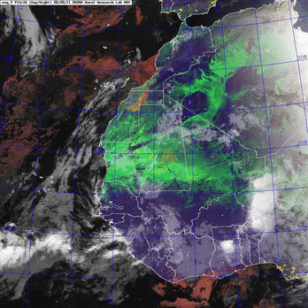
Rotation looks good but lacks convection.

0 likes
Visit the Caribbean-Central America Weather Thread where you can find at first post web cams,radars
and observations from Caribbean basin members Click Here
and observations from Caribbean basin members Click Here
-
Gustywind

- Category 5
- Posts: 12334
- Joined: Mon Sep 03, 2007 7:29 am
- Location: Baie-Mahault, GUADELOUPE
Re: ATL: INVEST 92L - Discussion
cycloneye wrote:Rotation looks good but lacks convection.
http://i.imgur.com/e6zSc.gif
Looks like. What are the latest estimations Cycloneye, the best track?
0 likes
-
cycloneye
- Admin
- Posts: 149426
- Age: 69
- Joined: Thu Oct 10, 2002 10:54 am
- Location: San Juan, Puerto Rico
Re: ATL: INVEST 92L - Discussion
What are the latest estimations Cycloneye, the best track?
Gusty, no best track updates have been released this morning.
0 likes
Visit the Caribbean-Central America Weather Thread where you can find at first post web cams,radars
and observations from Caribbean basin members Click Here
and observations from Caribbean basin members Click Here
-
SFLcane

- S2K Supporter

- Posts: 10281
- Age: 48
- Joined: Sat Jun 05, 2010 1:44 pm
- Location: Lake Worth Florida
Re: ATL: INVEST 92L - Discussion
Eastern tropical atlantic is closed for business for the time being...

0 likes
Who is online
Users browsing this forum: Google Adsense [Bot] and 21 guests