Checking in from St. Pete. First feederband of the year! woo lol
Surprised to see the code orange today.
ATL: INVEST 93L - DISCUSSION
Moderator: S2k Moderators
-
JonathanBelles
- Professional-Met

- Posts: 11430
- Age: 35
- Joined: Sat Dec 24, 2005 9:00 pm
- Location: School: Florida State University (Tallahassee, FL) Home: St. Petersburg, Florida
- Contact:

Re: ATL: INVEST 93L
Bring on westward to the Upper TX Coast. We need rain!
0 likes
The following post is NOT an official forecast and should not be used as such. It is just the opinion of the poster and may or may not be backed by sound meteorological data. It is NOT endorsed by any professional institution including storm2k.org For Official Information please refer to the NHC and NWS products.
-
otowntiger
- Category 5

- Posts: 1932
- Joined: Tue Aug 31, 2004 7:06 pm
Re: ATL: INVEST 93L
All of .31 inch of rain at my house in Orlando. Not much but enough that I can keep the sprinklers off until Saturday! I'll take it. We may still get a little more. 
0 likes
-
TreasureIslandFLGal

- S2K Supporter

- Posts: 1584
- Age: 58
- Joined: Sun Aug 15, 2004 6:16 pm
- Location: Cancun, Mexico (northeast Yucatan coast)

-
TreasureIslandFLGal
- S2K Supporter
- Posts: 1584
- Age: 58
- Joined: Sun Aug 15, 2004 6:16 pm
- Location: Cancun, Mexico (northeast Yucatan coast)
-
hurricanefloyd5

- Category 5
- Posts: 1659
- Age: 45
- Joined: Sun May 02, 2004 10:53 am
- Location: Spartanburg
- Contact:
Re:
TreasureIslandFLGal wrote:Definitely a gully washer here in central Pinellas County, Largo/Clearwater line. I'm just south of Ulmerton and it is really coming down.Thuder and lightning too, as we just momentarily lost power. -came right back on though.
well lost my cable and internet for a short time with the only lighting bolt in that storm
0 likes
-
tolakram
- Admin

- Posts: 20185
- Age: 62
- Joined: Sun Aug 27, 2006 8:23 pm
- Location: Florence, KY (name is Mark)
Re: ATL: INVEST 93L - DISCUSSION
http://www.ndbc.noaa.gov/station_page.php?station=41009
Clear wind shift, I think we have the center.

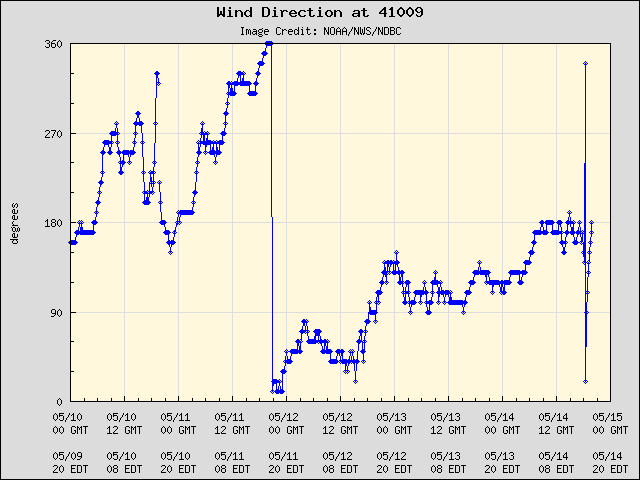
Clear wind shift, I think we have the center.
Last edited by tolakram on Wed Jun 01, 2011 12:30 pm, edited 1 time in total.
0 likes
M a r k
- - - - -
Join us in chat: Storm2K Chatroom Invite. Android and IOS apps also available.
The posts in this forum are NOT official forecasts and should not be used as such. Posts are NOT endorsed by any professional institution or STORM2K.org. For official information and forecasts, please refer to NHC and NWS products.

Re:
Hybridstorm_November2001 wrote:I noticed this area last night and I thought wow looks better short term than the mess in the Caribbean, how right I was. My goodness an invest with a moderate chance of development already, could be a nasty season ahead people.

Nice to have a little activity on Day 1 of the season. Gets us into the swing of things monitoring S2K right away.
I have to say though, that an invest on Day 1 does nothing to portend how active the forthcoming season will be.
I remember having TS's early in the season and then nothing for a month or two.
I just want SOMETHING, ANYTHING benign to develop to bring my area much needed rainfall. Like 10 inches or more over a 2-3 day period!!!!
At least Central and Northern Florida will get something from 93L to put out the fires and still smoldering embers.
0 likes
Re: ATL: INVEST 93L - DISCUSSION
Looking at the 12z GFS the shear across the northern gulf is pretty tame for the next two days, it may have a chance if it is still going once it crosses FL.

There are some 27c temps so that's ok, this one is moving along pretty good so no upwelling.

There are some 27c temps so that's ok, this one is moving along pretty good so no upwelling.
0 likes
-
thetruesms

- Professional-Met
- Posts: 844
- Age: 42
- Joined: Thu Aug 16, 2007 1:14 pm
- Location: Tallahasee, FL
- Contact:
Re: Re:
Honestly . . . any rain will help, and for those areas that are lucky enough to get under locally heavy rainfall, it may do a lot. But don't expect this to point a huge dent in the 244 active fires we have across the state right nowfci wrote:Hybridstorm_November2001 wrote:At least Central and Northern Florida will get something from 93L to put out the fires and still smoldering embers.

0 likes
Re: ATL: INVEST 93L - DISCUSSION
I have to say though, that an invest on Day 1 does nothing to portend how active the forthcoming season will be.
I remember having TS's early in the season and then nothing for a month or two.
Right - it doesn't mean anything - June is the time for weak systems like this that form and move inland quickly...
We'll just have to wait and see - it could be a busy season - but then again, it might not (lol)...
Frank
0 likes
-
HURAKAN

- Professional-Met
- Posts: 46084
- Age: 39
- Joined: Thu May 20, 2004 4:34 pm
- Location: Key West, FL
- Contact:
TROPICAL WEATHER OUTLOOK
NWS NATIONAL HURRICANE CENTER MIAMI FL
200 PM EDT WED JUN 1 2011
FOR THE NORTH ATLANTIC...CARIBBEAN SEA AND THE GULF OF MEXICO...
A SMALL AREA OF LOW PRESSURE LOCATED JUST TO THE EAST OF DAYTONA
BEACH FLORIDA IS MOVING WEST-SOUTHWESTWARD NEAR 20 MPH WITH
ASSOCIATED SHOWER AND THUNDERSTORM ACTIVITY SPREADING OVER PORTIONS
OF NORTHERN AND CENTRAL FLORIDA. SIGNIFICANT DEVELOPMENT OF THIS
SYSTEM IS NOT ANTICIPATED WHILE IT MOVES OVER LAND TODAY AND
TONIGHT...AND ENVIRONMENTAL CONDITIONS ARE ONLY MARGINALLY
FAVORABLE FOR DEVELOPMENT OVER THE NORTHERN GULF OF MEXICO ON
THURSDAY. LOCALLY HEAVY RAINFALL AND GUSTY WINDS ARE POSSIBLE OVER
NORTH-CENTRAL FLORIDA THROUGH TONIGHT. THERE IS A LOW CHANCE...20
PERCENT...OF THIS SYSTEM BECOMING A TROPICAL CYCLONE DURING THE
NEXT 48 HOURS. FOR ADDITIONAL INFORMATION ON THIS SYSTEM...PLEASE
SEE PRODUCTS FROM YOUR LOCAL NATIONAL WEATHER SERVICE OFFICE.
DISORGANIZED CLOUDINESS AND SHOWERS OVER THE SOUTHWESTERN AND
WEST-CENTRAL CARIBBEAN SEA ARE ASSOCIATED WITH A BROAD SURFACE
TROUGH. SOME GRADUAL DEVELOPMENT OF THIS SYSTEM IS POSSIBLE ONCE
UPPER-LEVEL WINDS BECOME A LITTLE MORE CONDUCIVE LATE THURSDAY AND
FRIDAY. THERE IS A LOW CHANCE...10 PERCENT...OF THIS SYSTEM
BECOMING A TROPICAL CYCLONE AS IT MOVES LITTLE DURING THE NEXT 48
HOURS.
ELSEWHERE...TROPICAL CYCLONE FORMATION IS NOT EXPECTED DURING THE
NEXT 48 HOURS.
ALL NATIONAL HURRICANE CENTER TEXT AND GRAPHICAL PRODUCTS ARE
AVAILABLE ON THE WEB AT http://WWW.HURRICANES.GOV. SIGN UP FOR PRODUCT
UPDATES BY EMAIL AT http://WWW.HURRICANES.GOV/SIGNUP.SHTML...IN ALL LOWER
CASE. YOU CAN ALSO INTERACT WITH US ON FACEBOOK AT
http://WWW.FACEBOOK.COM/US.NOAA.NATIONA ... CENTER.GOV.
$$
FORECASTER BERG/PASCH
0 likes
-
Hurricane

-
wxman57

- Moderator-Pro Met

- Posts: 23174
- Age: 68
- Joined: Sat Jun 21, 2003 8:06 pm
- Location: Houston, TX (southwest)
Re:
Hurricane wrote:Looks to be eying Texas... Question is how strong will it be? Anyone see a TS from this? Haven't taken a look at the Gulf temps and shear maps yet.
Most likely not much different from what's crossing Florida now. Some rain, hopefully, for us.
0 likes

-
dixiebreeze

- S2K Supporter
- Posts: 5140
- Joined: Wed Sep 03, 2003 5:07 pm
- Location: crystal river, fla.
Re: ATL: INVEST 93L MODELS
Just had very strong winds, lightening and quarter-inch hail in area from 93L. Calming down now as system heads into the gulf.
0 likes
Re: ATL: INVEST 93L - DISCUSSION
Right - there will likely be some sharp disagreements on this board in the coming months from those who are hurricane "fans" to those who are weary or fearful of the many natural disasters over the past year...
Probably the most intense lightning and thunder will come from the board itself more than anything (LOL)...
As for 93L - hopefully nothing much as it cross the Gulf, other than what we already see - the water temps in the Northern Gulf are only marginal...
Frank
Probably the most intense lightning and thunder will come from the board itself more than anything (LOL)...
As for 93L - hopefully nothing much as it cross the Gulf, other than what we already see - the water temps in the Northern Gulf are only marginal...
Frank
0 likes
-
Stormcenter
- S2K Supporter
- Posts: 6689
- Joined: Wed Sep 03, 2003 11:27 am
- Location: Houston, TX
It "looks" pretty impressive to me on satellite for a disturbance(invest).
http://www.ssd.noaa.gov/goes/east/gmex/flash-vis.html
http://www.ssd.noaa.gov/goes/east/gmex/flash-vis.html
0 likes
Who is online
Users browsing this forum: Google Adsense [Bot] and 21 guests