ATL: EARL - Models

Moderator: S2k Moderators

Message
Author
User avatar
ROCK
Category 5
Category 5
Posts: 9484
Age: 54
Joined: Tue Aug 17, 2004 7:30 am
Location: Kemah, Texas

Re: Re:

#981 Postby ROCK » Mon Aug 30, 2010 11:05 pm

Weatherfreak000 wrote:
ROCK wrote:
Steve wrote:Through 36 it still has a wnw heading.


looks more like NW to me Steve...hard to tell...shouldnt be going NW though with the high parked above it...


The short term motion just altogether appears off right from the start I would say. We may need the other models to come in and verify these ideas GFS has in the short term.


agree...seems to gain a lot of lat in the first 42 hours to be on a strict wnw heading...to me anyway...

Image
0 likes   

User avatar
Steve
S2K Supporter
S2K Supporter
Posts: 9620
Joined: Sat Apr 05, 2003 11:41 pm
Location: Not a state-caster

#982 Postby Steve » Mon Aug 30, 2010 11:05 pm

>>looks more like NW to me Steve...hard to tell...shouldnt be going NW though with the high parked above it...

If you zoom click through 36, it's still west of NW. HHC had the NW'ly motion in 24 hours. So it's got to be a little to the left of that. I haven't run past 36 yet though.
0 likes   

User avatar
boca
Category 5
Category 5
Posts: 6367
Age: 60
Joined: Mon Dec 15, 2003 8:49 am
Location: Boca Raton,FL

Re: ATL: EARL - Models

#983 Postby boca » Mon Aug 30, 2010 11:07 pm

A few days ago the models had Earl recurving east of the islands.
0 likes   

User avatar
SouthFLTropics
Category 5
Category 5
Posts: 4236
Age: 50
Joined: Thu Aug 14, 2003 8:04 am
Location: Port St. Lucie, Florida

Re: ATL: EARL - Models

#984 Postby SouthFLTropics » Mon Aug 30, 2010 11:09 pm

boca wrote:A few days ago the models had Earl recurving east of the islands.


Yeah...Kinda makes you wonder how much farther west they will bring the cone...

In reality the outside edge of the cone isn't that far from us Boca...

SFT
0 likes   
Fourth Generation Florida Native

Personal Storm History: David 79, Andrew 92, Erin 95, Floyd 99, Irene 99, Frances 04, Jeanne 04, Wilma 05, Matthew 16, Irma 17, Ian 22, Nicole 22, Milton 24

User avatar
ROCK
Category 5
Category 5
Posts: 9484
Age: 54
Joined: Tue Aug 17, 2004 7:30 am
Location: Kemah, Texas

Re: ATL: EARL - Models

#985 Postby ROCK » Mon Aug 30, 2010 11:09 pm

54hr....trof coming into play now....

http://www.nco.ncep.noaa.gov/pmb/nwprod ... n_054l.gif


Steve loop it here....looks NW..I dont know....

http://www.nco.ncep.noaa.gov/pmb/nwprod ... loop.shtml
0 likes   

User avatar
Steve
S2K Supporter
S2K Supporter
Posts: 9620
Joined: Sat Apr 05, 2003 11:41 pm
Location: Not a state-caster

#986 Postby Steve » Mon Aug 30, 2010 11:10 pm

Rock,

by 52 the movement was northwest from initialization to there. But if you dot your screen and watch through 36ish, it's to the left of NW. Thereafter, it looks to be making that up. So over the 2 1/2 days through 52, it's NW probably in the midst of a turn toward the north (as wx57 alluded to earlier with the North movement by Wed). But does it take it east of the Outer Banks and SE NC or does it come far enough under that when the turn happens, there's still a lot of weather to be dealt with. I'm intrigued.
0 likes   

User avatar
ROCK
Category 5
Category 5
Posts: 9484
Age: 54
Joined: Tue Aug 17, 2004 7:30 am
Location: Kemah, Texas

Re:

#987 Postby ROCK » Mon Aug 30, 2010 11:13 pm

Steve wrote:Rock,

by 52 the movement was northwest from initialization to there. But if you dot your screen and watch through 36ish, it's to the left of NW. Thereafter, it looks to be making that up. So over the 2 1/2 days through 52, it's NW probably in the midst of a turn toward the north (as wx57 alluded to earlier with the North movement by Wed). But does it take it east of the Outer Banks and SE NC or does it come far enough under that when the turn happens, there's still a lot of weather to be dealt with. I'm intrigued.


I see what you mean....BTW that trof looks less amplified than I would have thought...looks more zonal...

[img] http://www.nco.ncep.noaa.gov/pmb/nwprod ... 0_054l.gif[/img]
0 likes   

User avatar
Evil Jeremy
S2K Supporter
S2K Supporter
Posts: 5463
Age: 32
Joined: Mon Apr 10, 2006 2:10 pm
Location: Los Angeles, CA

Re: ATL: EARL - Models

#988 Postby Evil Jeremy » Mon Aug 30, 2010 11:14 pm

SouthFLTropics wrote:
boca wrote:A few days ago the models had Earl recurving east of the islands.


Yeah...Kinda makes you wonder how much farther west they will bring the cone...

In reality the outside edge of the cone isn't that far from us Boca...

SFT


You don't actually think we will feel Earl down here, do you? Is there actually a possibility?
0 likes   
Frances 04 / Jeanne 04 / Katrina 05 / Wilma 05 / Fay 08 / Debby 12 / Andrea 13 / Colin 16 / Hermine 16 / Matthew 16 / Irma 17

User avatar
Steve
S2K Supporter
S2K Supporter
Posts: 9620
Joined: Sat Apr 05, 2003 11:41 pm
Location: Not a state-caster

#989 Postby Steve » Mon Aug 30, 2010 11:14 pm

Yeah, that one does look more NW. At 850mb over MSLP, it's a little different earlier in the run. Check it out:

http://www.nco.ncep.noaa.gov/pmb/nwprod ... loop.shtml
0 likes   

Weatherfreak000

#990 Postby Weatherfreak000 » Mon Aug 30, 2010 11:14 pm

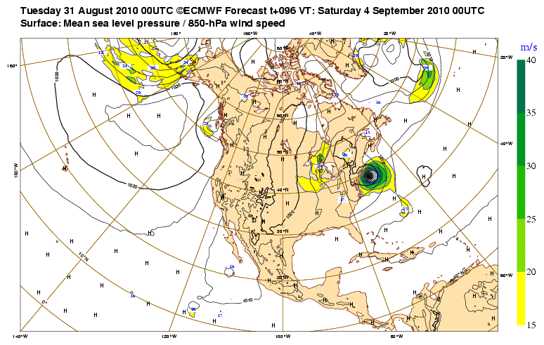
Out to 80 hours the trof picks this up...dangerously close to the EC.


I would say this setup is pretty dangerous
0 likes   

User avatar
Hybridstorm_November2001
S2K Supporter
S2K Supporter
Posts: 2811
Joined: Sat Aug 21, 2004 2:50 pm
Location: SW New Brunswick, Canada
Contact:

Re: ATL: EARL - Models

#991 Postby Hybridstorm_November2001 » Mon Aug 30, 2010 11:15 pm

Evil Jeremy wrote:
SouthFLTropics wrote:
boca wrote:A few days ago the models had Earl recurving east of the islands.


Yeah...Kinda makes you wonder how much farther west they will bring the cone...

In reality the outside edge of the cone isn't that far from us Boca...

SFT


You don't actually think we will feel Earl down here, do you? Is there actually a possibility?


The following post is NOT an official forecast and should not be used as such. It is just the opinion of the poster and may or may not be backed by sound meteorological data. It is NOT endorsed by any professional institution including storm2k.org For Official Information please refer to the NHC and NWS products.

No, Earl if it effects any land areas at all will be a Carolinas north to Nova Scotia storm.
Last edited by Hybridstorm_November2001 on Mon Aug 30, 2010 11:16 pm, edited 1 time in total.
0 likes   

User avatar
SouthFLTropics
Category 5
Category 5
Posts: 4236
Age: 50
Joined: Thu Aug 14, 2003 8:04 am
Location: Port St. Lucie, Florida

Re: ATL: EARL - Models

#992 Postby SouthFLTropics » Mon Aug 30, 2010 11:15 pm

Evil Jeremy wrote:
SouthFLTropics wrote:
boca wrote:A few days ago the models had Earl recurving east of the islands.


Yeah...Kinda makes you wonder how much farther west they will bring the cone...

In reality the outside edge of the cone isn't that far from us Boca...

SFT


You don't actually think we will feel Earl down here, do you? Is there actually a possibility?


My gut tells me no but when I watch the progression of the forecast track that steadily moves to the west...Well, it kinda makes you wonder... :double:
0 likes   
Fourth Generation Florida Native

Personal Storm History: David 79, Andrew 92, Erin 95, Floyd 99, Irene 99, Frances 04, Jeanne 04, Wilma 05, Matthew 16, Irma 17, Ian 22, Nicole 22, Milton 24

User avatar
ROCK
Category 5
Category 5
Posts: 9484
Age: 54
Joined: Tue Aug 17, 2004 7:30 am
Location: Kemah, Texas

Re: ATL: EARL - Models

#993 Postby ROCK » Mon Aug 30, 2010 11:15 pm

Image


east of NC and the coast...close call...
0 likes   

User avatar
boca
Category 5
Category 5
Posts: 6367
Age: 60
Joined: Mon Dec 15, 2003 8:49 am
Location: Boca Raton,FL

Re: ATL: EARL - Models

#994 Postby boca » Mon Aug 30, 2010 11:17 pm

Evil Jeremy wrote:
SouthFLTropics wrote:
boca wrote:A few days ago the models had Earl recurving east of the islands.


Yeah...Kinda makes you wonder how much farther west they will bring the cone...

In reality the outside edge of the cone isn't that far from us Boca...

SFT


You don't actually think we will feel Earl down here, do you? Is there actually a possibility?


No not at all I'm just saying how much of a shift west the models have taken Earl over a span of 48hrs.
0 likes   

T'Bonz
Category 1
Category 1
Posts: 421
Joined: Wed Sep 01, 2004 5:23 pm
Location: Cary, North Carolina

Re: ATL: EARL - Models

#995 Postby T'Bonz » Mon Aug 30, 2010 11:21 pm

heck this even has my attention if i was in FL....now it's a very low shot there.


Yep, it does and yes, it's a low shot. But I always watch the little $*#@!s until they're safely north of us and hope that they don't do a loop-de-loop or some other trick.

Bonz, in S. Florida, still watching.
0 likes   

shah8
Category 1
Category 1
Posts: 363
Joined: Wed Aug 30, 2006 4:36 pm

#996 Postby shah8 » Tue Aug 31, 2010 12:37 am

00z cmc keeps Earl low and along Hispaniola then does a very sharp turn north for awhile and then recurves out well south of OBX. It eats Fiona in the process. No new TS until a wave in currently in africa is offshore. I'm sorta ok with it but dubious. I'm just not much for deep systems changing directions in a major way like that.

edit: Be advised that path rakes Hispaniola far more than Earl raked PR, and SE Bahamas gets nuked.
0 likes   

shah8
Category 1
Category 1
Posts: 363
Joined: Wed Aug 30, 2006 4:36 pm

#997 Postby shah8 » Tue Aug 31, 2010 12:55 am

Comparing the cmc and gfs 00z was interesting. The primary difference is that the cmc is initially faster in a wnw motion than the gfs, which meant that the north portion of the journey started further south and ended further south of NC than the gfs Earl. There does seem to be a great many factors involved actually, with the wild card of Fiona developing. If Fiona truly gains strength, these 00z are going to be worthless, I think.
0 likes   

Wx_Warrior
Category 5
Category 5
Posts: 2718
Joined: Thu Aug 03, 2006 3:58 pm
Location: Beaumont, TX

Re: ATL: EARL - Models

#998 Postby Wx_Warrior » Tue Aug 31, 2010 1:58 am

Image
0 likes   

Brent
S2K Supporter
S2K Supporter
Posts: 38087
Age: 36
Joined: Sun May 16, 2004 10:30 pm
Location: Tulsa Oklahoma
Contact:

Re: ATL: EARL - Models

#999 Postby Brent » Tue Aug 31, 2010 2:11 am

Wowwwwwwwwwww

Image

Image

Image
0 likes   
#neversummer

supercane
S2K Supporter
S2K Supporter
Posts: 2858
Joined: Wed Sep 16, 2009 8:27 pm

#1000 Postby supercane » Tue Aug 31, 2010 2:29 am

GFS runs very consistent, with 00Z run in red:
Image

Other models also in fair agreement:
Image
0 likes   


Return to “2010”

Who is online

Users browsing this forum: No registered users and 6 guests