I say at Two AM it stays at 60%. Then tomorrow afternoon, if recon goes into it, I think it will be declared a tropical depression.
Personal Forecast Disclaimer:
The posts in this forum are NOT official forecast and should not be used as such. They are just the opinion of the poster and may or may not be backed by sound meteorological data. They are NOT endorsed by any professional institution or storm2k.org. For official information, please refer to the NHC and NWS products.
ATL: TROPICAL DEPRESSION BONNIE - DISCUSSION
Moderator: S2k Moderators

Re: ATL: INVEST 97L - DISCUSSION
Maybe something starting to pop near 850 vorticity max.


Still has a LOT to fight through though.
mid level shear.
upper level shear.
I'll change my tune if it makes through the next 24 hrs. as a 50% or better Invest. But I don't see it developing as quickly as some of the models do. But of course I'm still gonna watch it closely.
Still has a LOT to fight through though.
mid level shear.
upper level shear.
I'll change my tune if it makes through the next 24 hrs. as a 50% or better Invest. But I don't see it developing as quickly as some of the models do. But of course I'm still gonna watch it closely.
0 likes
The following post is NOT an official forecast and should not be used as such. It is just the opinion of the poster and may or may not be backed by sound meteorological data. It is NOT endorsed by any professional institution including storm2k.org For Official Information please refer to the NHC and NWS products.
-
floridasun78
- Category 5

- Posts: 3755
- Joined: Sun May 17, 2009 10:16 pm
- Location: miami fl

Re: ATL: INVEST 97L - DISCUSSION
Interesting wind profile here in the Keys. From 10 pm discussion:
OUR EVENING SOUNDING INDICATES EAST WINDS OF 20 AND 22 KNOTS AT 1
AND 2 THOUSAND FEET RESPECTIVELY WHILE THE KBYX VWP SHOWS 30 KNOTS
AT 1 THOUSAND FEET. WITH THE FORMIDABLE WESTERN ATLANTIC RIDGE
HOLDING FIRM ACROSS NORTH FLORIDA AND THE EXTREME SOUTHEAST UNITED
STATES AND C-MAN STATION OBSERVATIONS OVER THE LAST SEVERAL HOURS
SHOWING SUSTAINED WINDS NEAR 20 KNOTS WITH FREQUENT GUSTS
ABOVE...HAVE DECIDED TO HOIST A SMALL CRAFT ADVISORY FOR ALL WATERS.
&&
.AVIATION...
OUTSIDE OF AN OCCASIONAL MVFR CEILING/VISIBILITY...VFR CONDITIONS
WILL PREDOMINATE AT THE KEY WEST AND MARATHON TERMINALS. EAST TO
SOUTHEAST WINDS OF 17 TO 20 KNOTS WITH GUSTS NEAR 25 KNOTS AND EVEN
HIGHER NEAR PASSING SHOWERS WILL PERSIST OVERNIGHT AND INTO
WEDNESDAY. IN ADDITION...EAST TO SOUTHEAST WINDS OF 25 TO 30 KNOTS
WILL REACH UP TO 10000 FEET.
0 likes
-
SouthFloridawx

- S2K Supporter

- Posts: 8346
- Age: 47
- Joined: Tue Jul 26, 2005 1:16 am
- Location: Sarasota, FL
- Contact:
Re: ATL: INVEST 97L - DISCUSSION
It looked like it's being affected by wind shear. It's possible it may only still be an invest by tomorrow evening. Not much convection occurring now. You can see the tops being blow back to the east of the invest.

0 likes
Re: ATL: INVEST 97L - DISCUSSION

A little father north?
0 likes
The following post is NOT an official forecast and should not be used as such. It is just the opinion of the poster and may or may not be backed by sound meteorological data. It is NOT endorsed by any professional institution including storm2k.org For Official Information please refer to the NHC and NWS products.
-
Brent
- S2K Supporter
- Posts: 38777
- Age: 37
- Joined: Sun May 16, 2004 10:30 pm
- Location: Tulsa Oklahoma
- Contact:
Re: ATL: INVEST 97L - DISCUSSION
TROPICAL WEATHER OUTLOOK
NWS TPC/NATIONAL HURRICANE CENTER MIAMI FL
200 AM EDT WED JUL 21 2010
FOR THE NORTH ATLANTIC...CARIBBEAN SEA AND THE GULF OF MEXICO...
A STRONG TROPICAL WAVE...LOCATED NEAR THE EASTERN DOMINICAN REPUBLIC
AND EXTENDING NORTHWARD OVER THE ATLANTIC FOR A FEW HUNDRED
MILES...IS PRODUCING A LARGE AREA OF SHOWERS AND THUNDERSTORMS FROM
THE NORTHERN LEEWARD ISLANDS WESTWARD TO HISPANIOLA...AND OVER THE
ADJACENT WATERS OF THE ATLANTIC AND NORTHEASTERN CARIBBEAN SEA.
ALTHOUGH A CLOSED SURFACE CIRCULATION HAS NOT YET DEVELOPED...
ENVIRONMENTAL CONDITIONS ARE EXPECTED TO BECOME MORE CONDUCIVE FOR
TROPICAL CYCLONE FORMATION AS THE SYSTEM MOVES WEST-NORTHWESTWARD
AT ABOUT 10 MPH DURING THE NEXT DAY OR SO. THERE IS A HIGH
CHANCE...70 PERCENT...OF THIS SYSTEM BECOMING A TROPICAL DEPRESSION
OR A TROPICAL STORM DURING THE NEXT 48 HOURS. REGARDLESS OF
DEVELOPMENT...LOCALLY HEAVY RAINFALL AND GUSTY WINDS WILL CONTINUE
TO AFFECT THE VIRGIN ISLANDS AND PUERTO RICO...AND LIKELY AFFECT
THE DOMINICAN REPUBLIC...HAITI...EASTERN CUBA...THE TURKS AND
CAICOS ISLANDS...AND THE BAHAMAS DURING THE NEXT COUPLE OF DAYS.
THE HEAVY RAINS COULD CAUSE LIFE-THREATENING FLASH FLOODS AND MUD
SLIDES IN MOUNTAINOUS AREAS.
ELSEWHERE...TROPICAL CYCLONE FORMATION IS NOT EXPECTED DURING THE
NEXT 48 HOURS.
$$
FORECASTER STEWART
0 likes
#neversummer
-
chrisnnavarre
- Category 1

- Posts: 309
- Joined: Fri Oct 03, 2003 5:52 pm
- Contact:
Re: ATL: INVEST 97L - DISCUSSION
Looks like this has potential..i.e. could be bearing down on the Keys or South Florida in 48 hrs. Then possibly up into the Panhandle, at least that's my best guess. Hope it goes east of us, we don't need any storms along the Western Panhandle with the oil and everything. Economically it would kill us as far as tourism goes for the rest of the year, and we've already taken about as much depression as we can handle this year. Guess I'll check my generators tomorrow, and blow the dust off my PlyLox clips. Can anybody tell if this may go just a little bit south and maybe break up over Cuba?
0 likes

Re: ATL: INVEST 97L - DISCUSSION
Unless the NHC is seing something I'm not 97L looked better at 60% than it does at 70%.I guess they see something there. To me it looks like disorganized convection cloisters being blown off to the east due to the ULL to the NW.Nothing consolidating yet.
0 likes

Re: ATL: INVEST 97L - DISCUSSION
boca wrote:Unless the NHC is seing something I'm not 97L looked better at 60% than it does at 70%.I guess they see something there. To me it looks like disorganized convection cloisters being blown off to the east due to the ULL to the NW.Nothing consolidating yet.
Considering how bullish wxman and Mike W have been, there is definitely something there.
Let's just selfishly hope that shear and the ULL keep it in check.
We have seen MANY like this that have done many other things other than come into SFL as a TS or Hurricane.
Track through the Straits, not strengthen, go further north, poof..........
0 likes
-
Hurricane
I'm thinking a Tropical Depression at 4:00 PM tomorrow. Mark my words. 
Personal Forecast Disclaimer:
The posts in this forum are NOT official forecast and should not be used as such. They are just the opinion of the poster and may or may not be backed by sound meteorological data. They are NOT endorsed by any professional institution or storm2k.org. For official information, please refer to the NHC and NWS products.
0 likes

-
Meso

- Category 5
- Posts: 1609
- Age: 39
- Joined: Mon Aug 09, 2004 12:14 pm
- Location: South Africa
- Contact:
Re: ATL: INVEST 97L - DISCUSSION
Unless the NHC is seing something I'm not 97L looked better at 60% than it does at 70%.I guess they see something there. To me it looks like disorganized convection cloisters being blown off to the east due to the ULL to the NW.Nothing consolidating yet.
I think the important factor here is that the % of development is tied to a time period. As time progresses, if the system still looks to be developing, even slowly the chances will go up with time generally.
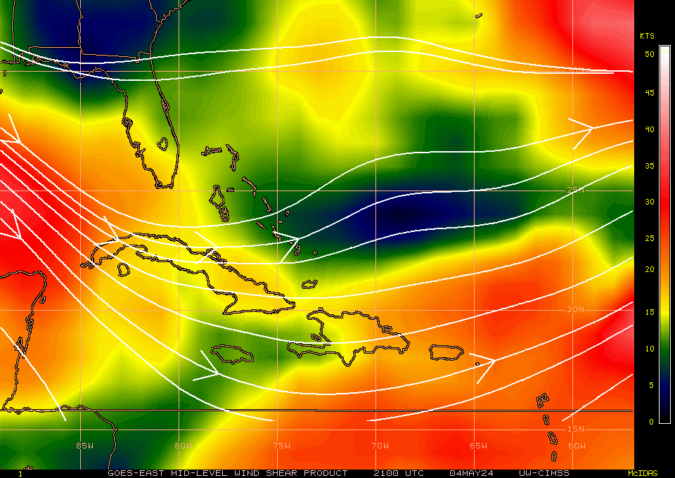
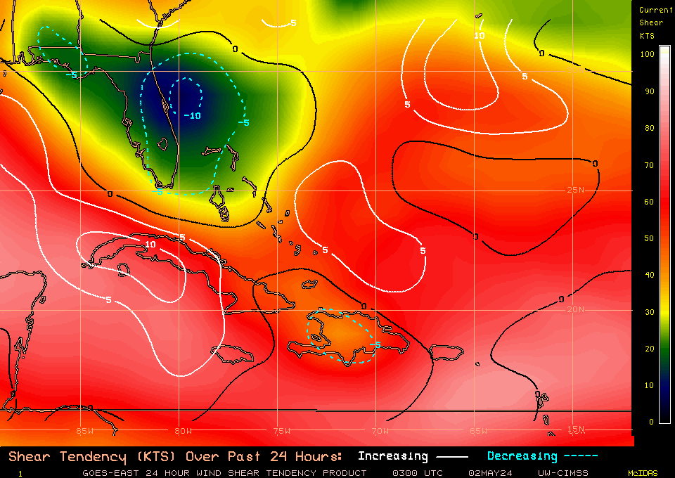
Has anyone got any shear forecast charts? I've seen the tendency charts but I lost the links for the forecasts (which seem to be pretty unreliable most of the time anyway).
0 likes
-
Hurricane
Re:
coreyl wrote:Am I the only one that thinks this looks like a big mess or the center is gonna end up way to the east of where we thought?
There isn't a closed circulation yet, so it is still unpredictable right now. But I don't think it will end up going more east... maybe west...
0 likes
-
americanre1
Re: ATL: INVEST 97L - DISCUSSION
I'm sorry, I really don't see anything to be worried about this wave at this moment. It is not a well organized wave at all. If it can consolidate over the next 2 to 3 days then I might start worrying. I'm more worried about the wave in the Middle Atlantic right now than this one.
Personal Forecast Disclaimer:
The posts in this forum are NOT official forecast and should not be used as such. They are just the opinion of the poster and may or may not be backed by sound meteorological data. They are NOT endorsed by any professional institution or storm2k.org. For official information, please refer to the NHC and NWS products
0 likes
-
knotimpaired

- Category 1
- Posts: 495
- Joined: Fri May 20, 2005 4:14 am
- Location: Vieques, PR
- Contact:
Re: ATL: INVEST 97L - DISCUSSION
Good morning everyone,
Vieques got hit really bad yesterday morning. It started at about 12:20 am and the heavy rain did not stop until about 5 am and we have light rain after that most of the day. We have had major flooding and also have many trees down. Not from the wind but the saturated ground.
All phones are out as well as DSL. I just now finally got a connection with my Sprint air card which I have for emergencies such as this. Businesses are not running as normal since they cannot take credit cards.
Before our weather station stopped transmitting at about 6 am yesterday we had received 5.80" of rain. We think it stopped transmitting due to the fact it is wireless and relies on its own solar power and we have not seen sun here since thursday or friday (to early to remember). It is a Weatherhawk system and when it comes back online you can see it at http://www.playacofi.com/weather
That's all for now, I will update the next time I get a connection.
K
0 likes

This haas gone right down the pan in the last few hours, no doubt this has shear on it from the east right now, the lower levels are a little too quick right now for development I reckon, the convection is being strung out and left behind.
If this trend carries on won't even have a TS to worry about in Florida yet alone a hurricane...down the line is still too uncertain yet but its quite obvious really this one is looking much less impressive than last night.
LA/TX LF looking more probable with a weaker system in the short term.
If this trend carries on won't even have a TS to worry about in Florida yet alone a hurricane...down the line is still too uncertain yet but its quite obvious really this one is looking much less impressive than last night.
LA/TX LF looking more probable with a weaker system in the short term.
0 likes
Personal Forecast Disclaimer:
The posts in this forum are NOT official forecast and should not be used as such. They are just the opinion of the poster and may or may not be backed by sound meteorological data. They are NOT endorsed by any professional institution or storm2k.org. For official information, please refer to the NHC and NWS products
The posts in this forum are NOT official forecast and should not be used as such. They are just the opinion of the poster and may or may not be backed by sound meteorological data. They are NOT endorsed by any professional institution or storm2k.org. For official information, please refer to the NHC and NWS products


The region to watch for any development is to the northm of Hispaniola, there probably is low level turning further to the west of the convection thatsb currently just to the north of DR....but will have to wait till Vis imagery to see whats what really.
0 likes
Personal Forecast Disclaimer:
The posts in this forum are NOT official forecast and should not be used as such. They are just the opinion of the poster and may or may not be backed by sound meteorological data. They are NOT endorsed by any professional institution or storm2k.org. For official information, please refer to the NHC and NWS products
The posts in this forum are NOT official forecast and should not be used as such. They are just the opinion of the poster and may or may not be backed by sound meteorological data. They are NOT endorsed by any professional institution or storm2k.org. For official information, please refer to the NHC and NWS products
Who is online
Users browsing this forum: No registered users and 34 guests