ATL: MATTHEW - Ex-Tropical Storm - Discussion
Moderator: S2k Moderators
-
wxman57

- Moderator-Pro Met

- Posts: 23175
- Age: 68
- Joined: Sat Jun 21, 2003 8:06 pm
- Location: Houston, TX (southwest)
Re: ATL: MATTHEW - Tropical Storm - Discussion
If Matthew doesn't slow down and start turning WNW it'll be inland over Nicaragua within 24 hrs.
0 likes
-
lonelymike
- S2K Supporter

- Posts: 634
- Joined: Sat Jul 26, 2008 10:12 am
- Location: walton county fla
Re: ATL: MATTHEW - Tropical Storm - Discussion
0 likes
GO SEMINOLES
Re: ATL: MATTHEW - Tropical Storm - Discussion
wxman57 wrote:If Matthew doesn't slow down and start turning WNW it'll be inland over Nicaragua within 24 hrs.
Wxman,
What's the office think longer term trackwise?
0 likes
-
Aquawind

- Category 5

- Posts: 6714
- Age: 62
- Joined: Mon Jun 16, 2003 10:41 pm
- Location: Salisbury, NC
- Contact:
Re: ATL: MATTHEW - Tropical Storm - Discussion
lonelymike wrote::uarrow: I think it would be good news for the states not so good news for Nicaragua
Well Said..Although it's going to affect them either way so it may as well go inland an weaken versus just off the coast and strengthening..
0 likes
-
latitude_20

- Tropical Storm

- Posts: 196
- Joined: Wed Jun 30, 2010 6:46 am
- Location: Tulum, Mexico
- Contact:
Re: ATL: MATTHEW - Tropical Storm - Discussion
Image loops look to me like it's holding to the projected track.
0 likes
-
Typhoon_Willie

- Category 5
- Posts: 1042
- Joined: Mon Jun 09, 2003 3:19 pm
- Location: Greenacres City, Florida
Re: ATL: MATTHEW - Tropical Storm - Discussion
Any coastal radars form Nicaragua and Honduras?
0 likes


-
jlauderdal
- S2K Supporter
- Posts: 7240
- Joined: Wed May 19, 2004 5:46 am
- Location: NE Fort Lauderdale
- Contact:
Re: ATL: MATTHEW - Tropical Storm - Discussion
latitude_20 wrote:Image loops look to me like it's holding to the projected track.
yep, they have been down there enough the last couple of days to have a handle on the steering currents
0 likes
-
SouthFLTropics

- Category 5
- Posts: 4258
- Age: 50
- Joined: Thu Aug 14, 2003 8:04 am
- Location: Port St. Lucie, Florida
One of the last visibles of the night is showing us a quickly developing system in the SW Caribbean. Take a good look before we lose visible for the night...
http://www.ssd.noaa.gov/goes/east/watl/flash-vis.html
SFT
http://www.ssd.noaa.gov/goes/east/watl/flash-vis.html
SFT
0 likes
Fourth Generation Florida Native
Personal Storm History: David 79, Andrew 92, Erin 95, Floyd 99, Irene 99, Frances 04, Jeanne 04, Wilma 05, Matthew 16, Irma 17, Ian 22, Nicole 22, Milton 24
Personal Storm History: David 79, Andrew 92, Erin 95, Floyd 99, Irene 99, Frances 04, Jeanne 04, Wilma 05, Matthew 16, Irma 17, Ian 22, Nicole 22, Milton 24
-
plasticup
Re: ATL: MATTHEW - Tropical Storm - Discussion
kevin wrote:Not a good part of the basin for a storm to be moving slowly over. These Yucatan systems are the worst.
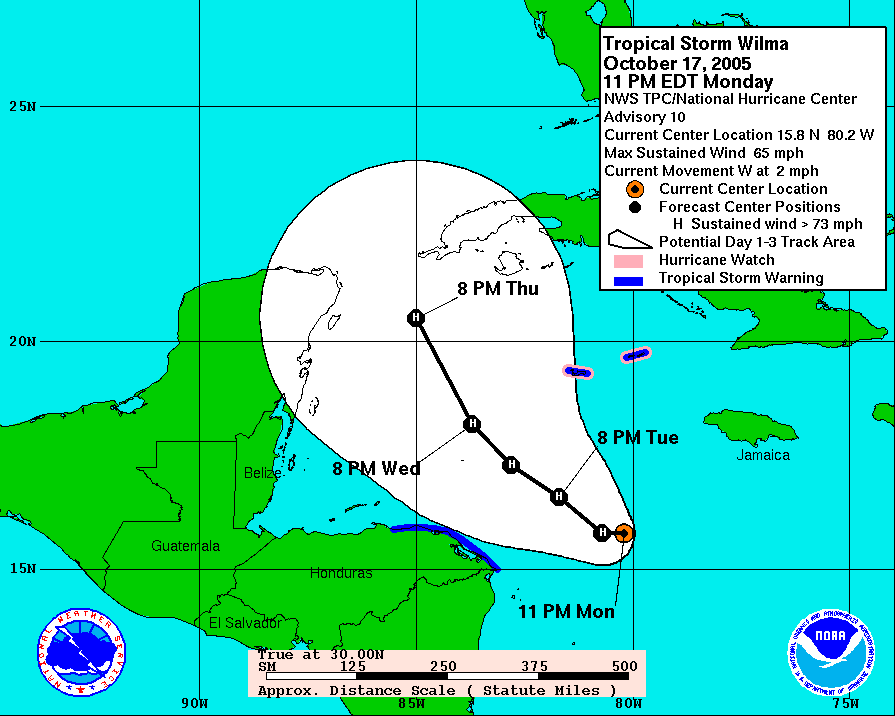
Matthew is going at 16 mph; that's a pretty good clip. By contrast, Wilma was only moving 2 mph when she was at the same location (link)
0 likes
-
bob rulz
- Category 5
- Posts: 1711
- Age: 36
- Joined: Sat Jan 28, 2006 7:30 pm
- Location: Salt Lake City, Utah
Re:
Aquawind wrote:Dang...Large with banding and deep convection firing near the center.. High Potential energy. Looks like the size alone is slowing the strengthening at this point like Alex..then again it was just classified 6 hours ago so..recon will be impressive in the morning..
I would hardly call this a slowly-strengthening storm and I'm very very surprised that the NHC held at 40mph at 8pm.
0 likes
Re: ATL: MATTHEW - Tropical Storm - Discussion
man we are crankin out the names......prob headed to 19 or so
matthew seems a bit large with not so much water in front of him.....i think it would have to thread the needle with the track and speed to stay over enough water to strengthen more than slowly .....
matthew seems a bit large with not so much water in front of him.....i think it would have to thread the needle with the track and speed to stay over enough water to strengthen more than slowly .....
0 likes
-
Aquawind
- Category 5
- Posts: 6714
- Age: 62
- Joined: Mon Jun 16, 2003 10:41 pm
- Location: Salisbury, NC
- Contact:
Re: Re:
bob rulz wrote:Aquawind wrote:Dang...
I would hardly call this a slowly-strengthening storm and I'm very very surprised that the NHC held at 40mph at 8pm.
You should know..they don't go by visuals alone..evidently the sat estimates don't support it and without recon or surface obs no change. They don't do alot guessing or assuming at the NHC.. it's just getting started as I mentioned..
0 likes
-
Aric Dunn
- Category 5
- Posts: 21238
- Age: 43
- Joined: Sun Sep 19, 2004 9:58 pm
- Location: Ready for the Chase.
- Contact:
Re: ATL: MATTHEW - Tropical Storm - Discussion
fairly evident where the center was a couple hours ago.

0 likes
Note: If I make a post that is brief. Please refer back to previous posts for the analysis or reasoning. I do not re-write/qoute what my initial post said each time.
If there is nothing before... then just ask
Space & Atmospheric Physicist, Embry-Riddle Aeronautical University,
I believe the sky is falling...
If there is nothing before... then just ask
Space & Atmospheric Physicist, Embry-Riddle Aeronautical University,
I believe the sky is falling...
Who is online
Users browsing this forum: No registered users and 43 guests