
ATL: FIONA - Models
Moderator: S2k Moderators
-
Wx_Warrior
- Category 5

- Posts: 2718
- Joined: Thu Aug 03, 2006 3:58 pm
- Location: Beaumont, TX
-
Wx_Warrior
- Category 5
- Posts: 2718
- Joined: Thu Aug 03, 2006 3:58 pm
- Location: Beaumont, TX
-
Ivanhater

- Storm2k Moderator

- Posts: 11222
- Age: 39
- Joined: Fri Jul 01, 2005 8:25 am
- Location: Pensacola
Re: ATL: 97L - Models
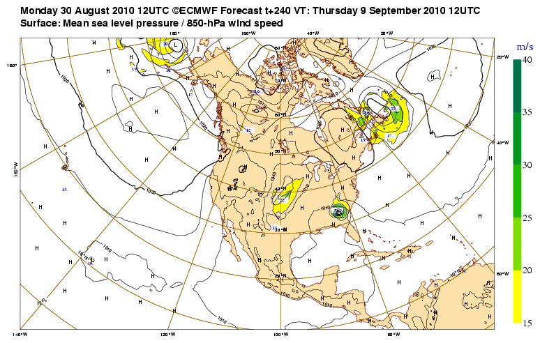
Yall gotta stop being so quick to think recurve when trying to guess what the run is showing 
Euro still building a strong high and pushes it back west toward South Carolina...
Euro still building a strong high and pushes it back west toward South Carolina...
0 likes
Michael
Re: ATL: 97L - Models
So the Euro is back to the solution it had this weekend, with landfall into the Southeast
So let's see...we've had the Euro go into SC, Port. St. Lucie, Cuba/Louisiana, fish, Georgia
Also, that is one monster high planted in the SE
So let's see...we've had the Euro go into SC, Port. St. Lucie, Cuba/Louisiana, fish, Georgia
Also, that is one monster high planted in the SE
Last edited by caneseddy on Mon Aug 30, 2010 1:58 pm, edited 1 time in total.
0 likes
-
Wx_Warrior
- Category 5
- Posts: 2718
- Joined: Thu Aug 03, 2006 3:58 pm
- Location: Beaumont, TX


-
SeminoleWind

- Category 1

- Posts: 359
- Age: 51
- Joined: Wed Jun 02, 2010 8:37 pm
- Location: Lake County Florida
Wondering if it will shift even further south again on the next run
0 likes
This post is NOT an official forecast and should not be used as such. It is just the opinion of the poster and may or may not be backed by sound meteorological data. It is NOT endorsed by any professional institution including storm2k.org For Official Information please refer to the NHC and NWS products.
It’s becoming more and more apparent that it will be critical in how far NW Fiona will travel as a result of earl’s weakness. Once the weakness fills and ridging builds she’s coming back west…The euro has been on to this solution for days now…The only real differences is how far N Fiona gets before the turn back but the solution of building in a deep ridge remains unchanged…
0 likes


-
Ivanhater
- Storm2k Moderator
- Posts: 11222
- Age: 39
- Joined: Fri Jul 01, 2005 8:25 am
- Location: Pensacola
Re: ATL: 97L - Models
That is one strong high building in and may induce a WSW motion as the Euro is showing a Georgia landfall


0 likes
Michael
-
SouthFLTropics

- Category 5
- Posts: 4258
- Age: 50
- Joined: Thu Aug 14, 2003 8:04 am
- Location: Port St. Lucie, Florida
Re: ATL: 97L - Models
caneseddy wrote:So the Euro is back to the solution it had this weekend, with landfall into the Southeast
So let's see...we've had the Euro go into SC, Port. St. Lucie, Cuba/Louisiana, fish, Georgia
Also, that is one monster high planted in the SE
If I had to guess the ultimate answer will lie somewhere in between...Which the midpoint between the SC landfall and a Cuba/Lousiana landfall would be somewhere along the FL East Coast...Unfortunately...
SFT
0 likes
Fourth Generation Florida Native
Personal Storm History: David 79, Andrew 92, Erin 95, Floyd 99, Irene 99, Frances 04, Jeanne 04, Wilma 05, Matthew 16, Irma 17, Ian 22, Nicole 22, Milton 24
Personal Storm History: David 79, Andrew 92, Erin 95, Floyd 99, Irene 99, Frances 04, Jeanne 04, Wilma 05, Matthew 16, Irma 17, Ian 22, Nicole 22, Milton 24

Re: ATL: 97L - Models
Off topic but did anyone notice the lowering pressures in the western caribbean toward the end of that Euro run?
0 likes
Re: ATL: 97L - Models
Vortex wrote:Great post mike as usual....What are your personal thoughts on 97?
Hi Vortex/Artist...
I will get something together tonight for the main thread, but I think the 12Z Euro's idea in terms of the synoptic pattern works...the big key is will 97L stay far enough away from Earl?
Typically, I would be looking for an upper low to develop in the area trailing Earl (where 97 is now). My guess is there is upper level convergence going on there, suppressing some of the upward motion coming from the surface. As long as 97L remains in that relative position, it's going to struggle to get deep convection going on a sustained basis...and the Euro shows this.
However, once Earl begins hauling the mail to the north, it will leave behind a better upper pattern...
So, I really don't think we will see significant intensification from 97L even if it gets an upgrade for 2 more days, but by Wednesday/Thursday it should start taking shape.
Hard to speculate on a landfall point, or even if it will be a problem for the US or others just yet, other than saying I am more concerned down the road about this system than Earl.
MW
0 likes
Updating on the twitter now: http://www.twitter.com/@watkinstrack
-
senorpepr

- Military Met/Moderator

- Posts: 12542
- Age: 43
- Joined: Fri Aug 22, 2003 9:22 pm
- Location: Mackenbach, Germany
- Contact:
For morale...
Code: Select all
WHXX01 KWBC 301908
CHGHUR
TROPICAL CYCLONE GUIDANCE MESSAGE
NWS TPC/NATIONAL HURRICANE CENTER MIAMI FL
1908 UTC MON AUG 30 2010

DISCLAIMER...NUMERICAL MODELS ARE SUBJECT TO LARGE ERRORS.
PLEASE REFER TO NHC OFFICIAL FORECASTS FOR TROPICAL CYCLONE
AND SUBTROPICAL CYCLONE INFORMATION.

ATLANTIC OBJECTIVE AIDS FOR

DISTURBANCE INVEST (AL972010) 20100830 1800 UTC

        ...00 HRS...   ...12 HRS...   ...24 HRS. ..   ...36 HRS...
        100830  1800   100831  0600   100831  1800   100901  0600

         LAT    LON     LAT    LON     LAT    LON     LAT    LON
BAMS    14.2N  47.7W   14.8N  51.3W   16.1N  54.8W   17.9N  58.4W
BAMD    14.2N  47.7W   14.5N  51.1W   15.1N  54.3W   15.9N  57.7W
BAMM    14.2N  47.7W   14.4N  51.3W   15.2N  54.6W   16.5N  58.0W
LBAR    14.2N  47.7W   14.4N  51.3W   15.0N  55.2W   15.8N  59.0W
SHIP        35KTS          43KTS          51KTS          59KTS
DSHP        35KTS          43KTS          51KTS          59KTS

        ...48 HRS...   ...72 HRS...   ...96 HRS. ..   ..120 HRS...
        100901  1800   100902  1800   100903  1800   100904  1800

         LAT    LON     LAT    LON     LAT    LON     LAT    LON
BAMS    20.7N  61.8W   28.4N  65.5W   36.4N  62.2W   43.9N  55.1W
BAMD    16.9N  60.9W   19.3N  67.6W   20.2N  72.9W   19.0N  78.6W
BAMM    18.3N  61.0W   22.8N  65.6W   25.9N  67.0W   26.2N  67.2W
LBAR    17.1N  62.6W   19.9N  67.8W   19.1N  71.6W     .0N    .0W
SHIP        64KTS          65KTS          58KTS          58KTS
DSHP        64KTS          65KTS          58KTS          58KTS

         ...INITIAL CONDITIONS...
LATCUR =  14.2N LONCUR =  47.7W DIRCUR = 270DEG SPDCUR =  21KT
LATM12 =  14.1N LONM12 =  42.9W DIRM12 = 275DEG SPDM12 =  20KT
LATM24 =  13.9N LONM24 =  39.7W
WNDCUR =   35KT RMAXWD =  120NM WNDM12 =   25KT
CENPRS = 1007MB OUTPRS = 1011MB OUTRAD =  180NM SDEPTH =   S
RD34NE =  120NM RD34SE =    0NM RD34SW =    0NM RD34NW =   0NM

$$
NNNN
0 likes
Re: ATL: 97L - Models
I'm thinking that Earl's outflow may eventually destroy 97L or prevent it from really developing.
0 likes
-
5KOVERLIBOR
Re: Re:
MWatkins wrote:5KOVERLIBOR wrote:First-time poster, long-time lurker, and I'll be going back to that following this.
This is an excellent site, and I can tell you people use this. Professionals use this site as a tool. So, I say this with all due respect for those who run a rare gem on the info super camino.
This is the model thread for 97L. The GFS operational is now through 150 hours and...no Fiona. For the second straight on-the-run run (0z was missing her as well) there is no development of Fiona. Importantly, the GFS op was seeing her yesterday, and has now dropped her since yesterday's 18z.
And there is no discussion of it on this board? I can't read the good thoughts of those who contribute as to why a global model that had Fiona consistently no longer has her? I get that this isn't a cane model, I get that the GFS can be as capricious as a pack of 13-yr old girls mealing on pixie sticks at the mall. But why isn't anyone talking about it? That's what this site does, it talks about that. Where is that?
Bleeping great question. I suppose, if there weren't 2 active hurricanes going on there would be more talk about this...but as such some folks are distracted and others, because these hurricanes don't look to threaten the US, are disinterested.
However, the GFS not seeing a feature is not new. Back in 2003, Isabel was a major hurricane yet for some reason, the GFS couldn't resolve it (at all) in the model fields. Talk got so heated around that subject that people believed it was a government conspiracy to cover up the hurricane in the model, so people wouldn't see where it might go!
My guess is three-fold:
1. The system is very shallow and has had a difficult time sustaining deep convection, despite the overall low coud structure. As a result, the GFS isn't initializing much vorticity in 850MB fields initially, and isn't creating enough "modeled" convergance to spin up the cyclone.
2. The thermodynamic environment around 97L isn't super favorable. Earl and Danielle struggled in this area too....
3. Earl is growing to be a significant cyclone, and the outflow from Earl could choke whatever 97 is trying to muster. However, this has also been showing up as a physics problem because the GFS has wanted to absorb 97L into Earl, again because it doesn't seem to have a handle on what's actually happening with 97l.
GFS and the other global models didn't see Felix when it was a 5 a couple of years ago...again not sure why. But it's probably because in terms of the global models, tropical cyclones are such small synoptic features the don't always show up in the grids.
I hope this helps, and keep the good questions coming!
MW
MW, tip of the hat sir. Much gratitude for your knowledge and time.
I've been on the site, of and on, for about 5 years, just registering this year. I am concerned that bias is playing an ever greater role on this site, not something I and others that use this excellent site find to be a positive.
If the model shows development, it gets its picture taken. If not, it isn't even mentioned. Not the best for a model thread.
0 likes
Who is online
Users browsing this forum: No registered users and 92 guests