EPAC : EX TROPICAL DEPRESSION AGATHA

Moderator: S2k Moderators

Message
Author
User avatar
gatorcane
S2K Supporter
S2K Supporter
Posts: 23691
Age: 47
Joined: Sun Mar 13, 2005 3:54 pm
Location: Boca Raton, FL

#61 Postby gatorcane » Wed May 26, 2010 8:52 pm

The posts in this forum are NOT official forecast and should not be used as such. They are just the opinion of the poster and may or may not be backed by sound meteorological data. They are NOT endorsed by any professional institution or storm2k.org. For official information, please refer to the NHC and NWS products.


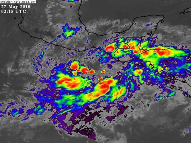
There is quite a nice upper-high over this system as shown by the nice symmetric fanning of the convection around the broad surface low. This is what you want to see if you are looking for development. SSTs are warm as well. Convection has waned some over the last 6 hours, but certainly a lot of disturbed weather. The NHC code orange is exactly where I would put it at this point as well. If some more convection develops and consolidates some, it could go to code RED, however at this time, I am leaning towards no named system out of this. Main reason is that it seems to have become more disorganized and is slowly going to drift over land limiting its time over water.
0 likes   

User avatar
HURAKAN
Professional-Met
Professional-Met
Posts: 46086
Age: 38
Joined: Thu May 20, 2004 4:34 pm
Location: Key West, FL
Contact:

#62 Postby HURAKAN » Wed May 26, 2010 9:35 pm

Image

Taking shape
0 likes   

User avatar
HURAKAN
Professional-Met
Professional-Met
Posts: 46086
Age: 38
Joined: Thu May 20, 2004 4:34 pm
Location: Key West, FL
Contact:

#63 Postby HURAKAN » Wed May 26, 2010 9:47 pm

Image

Consensus
0 likes   

User avatar
HURAKAN
Professional-Met
Professional-Met
Posts: 46086
Age: 38
Joined: Thu May 20, 2004 4:34 pm
Location: Key West, FL
Contact:

Re: EPAC : INVEST 90E

#64 Postby HURAKAN » Thu May 27, 2010 12:04 am

Image

Latest
0 likes   

User avatar
Macrocane
Category 5
Category 5
Posts: 4218
Age: 36
Joined: Sun May 24, 2009 5:35 pm
Location: El Salvador

Re: EPAC : INVEST 90E

#65 Postby Macrocane » Thu May 27, 2010 12:08 am

The convection is developing again, let's see if this time it persists for a longer time, and I think that the low will be relocated southeast of the actual location.
0 likes   

User avatar
somethingfunny
ChatStaff
ChatStaff
Posts: 3926
Age: 37
Joined: Thu May 31, 2007 10:30 pm
Location: McKinney, Texas

Re: EPAC : INVEST 90E

#66 Postby somethingfunny » Thu May 27, 2010 12:21 am

Oh my. 90E is really getting into gear now. It can't be long before this is classified. Tropical depression by noon is my guess.

Macrocane, I trust that you have made all your preparations and encouraged your friends, family and neighbors to do the same?
0 likes   

User avatar
KWT
Category 5
Category 5
Posts: 31415
Joined: Tue Aug 17, 2004 11:02 am
Location: UK!!!

#67 Postby KWT » Thu May 27, 2010 4:15 am

Convection blowing up again with this system, also getting a very good looking circulation with the convection arching around the systems center. Getting a depression look now IMO...code red round the corner.
0 likes   
Personal Forecast Disclaimer:
The posts in this forum are NOT official forecast and should not be used as such. They are just the opinion of the poster and may or may not be backed by sound meteorological data. They are NOT endorsed by any professional institution or storm2k.org. For official information, please refer to the NHC and NWS products

User avatar
HURAKAN
Professional-Met
Professional-Met
Posts: 46086
Age: 38
Joined: Thu May 20, 2004 4:34 pm
Location: Key West, FL
Contact:

Re: EPAC : INVEST 90E

#68 Postby HURAKAN » Thu May 27, 2010 6:33 am

TROPICAL WEATHER OUTLOOK
NWS TPC/NATIONAL HURRICANE CENTER MIAMI FL
500 AM PDT THU MAY 27 2010

FOR THE EASTERN NORTH PACIFIC...EAST OF 140 DEGREES WEST LONGITUDE..

THE BROAD AREA OF LOW PRESSURE CENTERED A COUPLE OF HUNDRED MILES
SOUTH OF THE GULF OF TEHUANTEPEC IS SHOWING SIGNS OF BECOMING
BETTER ORGANIZED. ENVIRONMENTAL CONDITIONS ARE FAVORABLE FOR
GRADUAL DEVELOPMENT...AND A TROPICAL DEPRESSION COULD FORM DURING
THE NEXT DAY OR SO. THE SYSTEM IS EXPECTED TO MOVE LITTLE OR DRIFT
SLOWLY NORTHEASTWARD OVER THE NEXT COUPLE OF DAYS...AND HAS THE
POTENTIAL TO PRODUCE LOCALLY HEAVY RAINS...FLOODING...AND MUD
SLIDES OVER PORTIONS OF CENTRAL AMERICA...ESPECIALLY OVER EL
SALVADOR...SOUTHERN HONDURAS...AND COASTAL GUATEMALA. THERE IS A
HIGH CHANCE...60 PERCENT...OF THIS SYSTEM BECOMING A TROPICAL
CYCLONE DURING THE NEXT 48 HOURS.

ELSEWHERE...TROPICAL CYCLONE FORMATION IS NOT EXPECTED DURING THE
NEXT 48 HOURS.

$$
FORECASTER STEWART/PASCH
0 likes   

User avatar
cycloneye
Admin
Admin
Posts: 145271
Age: 68
Joined: Thu Oct 10, 2002 10:54 am
Location: San Juan, Puerto Rico

Re: EPAC : INVEST 90E

#69 Postby cycloneye » Thu May 27, 2010 6:37 am

Image
0 likes   
Visit the Caribbean-Central America Weather Thread where you can find at first post web cams,radars
and observations from Caribbean basin members Click Here

User avatar
HURAKAN
Professional-Met
Professional-Met
Posts: 46086
Age: 38
Joined: Thu May 20, 2004 4:34 pm
Location: Key West, FL
Contact:

Re: EPAC : INVEST 90E

#70 Postby HURAKAN » Thu May 27, 2010 6:38 am

Image

Latest
0 likes   

User avatar
KWT
Category 5
Category 5
Posts: 31415
Joined: Tue Aug 17, 2004 11:02 am
Location: UK!!!

#71 Postby KWT » Thu May 27, 2010 6:46 am

Not all that surprising given the convective burst that developed over the last 12hrs or so, esp as the convection seems to be banding somewhat round the center of the low.

The 0z GFDL very agressive with this one, takes it upto about 75-80kts before landfall, needs to be watched closely, but much depends how long it has over water.
0 likes   
Personal Forecast Disclaimer:
The posts in this forum are NOT official forecast and should not be used as such. They are just the opinion of the poster and may or may not be backed by sound meteorological data. They are NOT endorsed by any professional institution or storm2k.org. For official information, please refer to the NHC and NWS products

User avatar
HURAKAN
Professional-Met
Professional-Met
Posts: 46086
Age: 38
Joined: Thu May 20, 2004 4:34 pm
Location: Key West, FL
Contact:

#72 Postby HURAKAN » Thu May 27, 2010 6:51 am

06z

EP, 90, 2010052706, , BEST, 0, 128N, 944W, 25, 1006, DB
0 likes   

clfenwi
Category 5
Category 5
Posts: 3331
Joined: Thu Jun 09, 2005 12:54 pm

Re: EPAC : INVEST 90E

#73 Postby clfenwi » Thu May 27, 2010 7:31 am

Still not meriting T numbers from SSD:

27/1145 UTC 12.3N 95.6W TOO WEAK 90E
0 likes   

User avatar
cycloneye
Admin
Admin
Posts: 145271
Age: 68
Joined: Thu Oct 10, 2002 10:54 am
Location: San Juan, Puerto Rico

Re: EPAC : INVEST 90E

#74 Postby cycloneye » Thu May 27, 2010 7:36 am

12z Best track,Nearly stationary.

EP, 90, 2010052712, , BEST, 0, 128N, 945W, 25, 1006, LO
0 likes   
Visit the Caribbean-Central America Weather Thread where you can find at first post web cams,radars
and observations from Caribbean basin members Click Here

User avatar
srainhoutx
S2K Supporter
S2K Supporter
Posts: 6919
Age: 67
Joined: Sun Jan 14, 2007 11:34 am
Location: Haywood County, NC
Contact:

Re: EPAC : INVEST 90E

#75 Postby srainhoutx » Thu May 27, 2010 7:57 am

I would not be surprised to see a Depression declared later today.

The following post is NOT an official forecast and should not be used as such. It is just the opinion of the poster and may or may not be backed by sound meteorological data. It is NOT endorsed by any professional institution including storm2k.org For Official Information please refer to the NHC and NWS products.
0 likes   
Carla/Alicia/Jerry(In The Eye)/Michelle/Charley/Ivan/Dennis/Katrina/Rita/Wilma/Ike/Harvey

Member: National Weather Association
Wx Infinity Forums
http://wxinfinity.com/index.php

Facebook.com/WeatherInfinity
Twitter @WeatherInfinity

User avatar
Macrocane
Category 5
Category 5
Posts: 4218
Age: 36
Joined: Sun May 24, 2009 5:35 pm
Location: El Salvador

Re: EPAC : INVEST 90E

#76 Postby Macrocane » Thu May 27, 2010 8:00 am

somethingfunny wrote:Oh my. 90E is really getting into gear now. It can't be long before this is classified. Tropical depression by noon is my guess.

Macrocane, I trust that you have made all your preparations and encouraged your friends, family and neighbors to do the same?


Well, I've told my family and my friends that a big rain was very possible and it has been in the news too but unfortunately only the people that live in areas that have experienced disasters in previous events take this news as a serious threat. At this time we're under yellow alert, if it is upgraded to orange people will take it more seriously, let's hope that nothing bad happens but you're right we always need to be prepared.
0 likes   

User avatar
cycloneye
Admin
Admin
Posts: 145271
Age: 68
Joined: Thu Oct 10, 2002 10:54 am
Location: San Juan, Puerto Rico

Re: EPAC : INVEST 90E

#77 Postby cycloneye » Thu May 27, 2010 8:27 am

First visible image.

Image
0 likes   
Visit the Caribbean-Central America Weather Thread where you can find at first post web cams,radars
and observations from Caribbean basin members Click Here

User avatar
KWT
Category 5
Category 5
Posts: 31415
Joined: Tue Aug 17, 2004 11:02 am
Location: UK!!!

Re: EPAC : INVEST 90E

#78 Postby KWT » Thu May 27, 2010 9:05 am

cycloneye wrote:12z Best track,Nearly stationary.

EP, 90, 2010052712, , BEST, 0, 128N, 945W, 25, 1006, LO


Yep just a slight westward drift over the last 6hrs or so, tough call with this one as to how long it continues to drift westwards, the GFDL still has another 24hrs or so of slight drifting before it turns NE.
0 likes   
Personal Forecast Disclaimer:
The posts in this forum are NOT official forecast and should not be used as such. They are just the opinion of the poster and may or may not be backed by sound meteorological data. They are NOT endorsed by any professional institution or storm2k.org. For official information, please refer to the NHC and NWS products

User avatar
HURAKAN
Professional-Met
Professional-Met
Posts: 46086
Age: 38
Joined: Thu May 20, 2004 4:34 pm
Location: Key West, FL
Contact:

#79 Postby HURAKAN » Thu May 27, 2010 9:53 am

Image

Latest
0 likes   

User avatar
cycloneye
Admin
Admin
Posts: 145271
Age: 68
Joined: Thu Oct 10, 2002 10:54 am
Location: San Juan, Puerto Rico

Re: EPAC : INVEST 90E

#80 Postby cycloneye » Thu May 27, 2010 11:15 am

Tropical Cyclone Formation Alert

WTPN21 PHNC 271400
MSGID/GENADMIN/NAVMARFCSTCEN PEARL HARBOR HI/JTWC//
SUBJ/TROPICAL CYCLONE FORMATION ALERT//
RMKS/
1. FORMATION OF A SIGNIFICANT TROPICAL CYCLONE IS POSSIBLE WITHIN
A 160 NM RADIUS OF 12.9N 94.5W WITHIN THE NEXT 12 TO 24 HOURS.
AVAILABLE DATA DOES NOT JUSTIFY ISSUANCE OF NUMBERED TROPICAL
CYCLONE WARNINGS AT THIS TIME. WINDS IN THE AREA ARE ESTIMATED TO
BE 20 TO 25 KNOTS. METSAT IMAGERY AT 271330Z INDICATES THAT A
CIRCULATION CENTER IS LOCATED NEAR 12.8N 94.5W. THE SYSTEM IS
MOVING WESTWARD AT 01 KNOTS.
2. REMARKS: THE AREA OF CONVECTION IS LOCATED NEAR 12.8N 94.5W,
APPROXIMATELY 205 NM SOUTH OF SALINA CRUZ, MEXICO. ANIMATED
INFRARED SATELLITE IMAGERY INDICATES A SLOWLY CONSOLIDATING,
BROAD LOW-LEVEL CIRCULATION CENTER (LLCC). ANIMATED WATER VAPOR
IMAGERY DEPICTS GOOD RADIAL OUFLOW ASSOCIATED WITH AN ANTICYCLONE
OVER THE SYSTEM. A 270759Z AMSR-E IMAGE SHOWED A BROAD LLCC WITH
FORMATIVE BANDING ALONG THE SOUTHERN PERIPHERY. A 270404Z ASCAT
AMBIGUITY ANALYSIS DEPICTED A DEVELOPING LLCC WITH 15-20 KNOT WINDS
OVER THE SOUTHERN SEMI-CIRCLE. THERE IS LOW CONFIDENCE IN THE CENTER
POSITION DUE TO THE BROAD NATURE OF THE LLCC. BASED ON THE FAVORABLE
ENVIRONMENT, THE LLCC IS EXPECTED TO CONTINUE CONSOLIDATING OVER THE
NEXT 24-36 HOURS. MAXIMUM SUSTAINED SURFACE WINDS ARE ESTIMATED AT
20 TO 25 KNOTS. MINIMUM SEA LEVEL PRESSURE IS ESTIMATED TO BE NEAR
1006 MB. THE POTENTIAL FOR THE DEVELOPMENT OF A SIGNIFICANT TROPICAL
CYCLONE WITHIN THE NEXT 24 HOURS IS GOOD.

Image
0 likes   
Visit the Caribbean-Central America Weather Thread where you can find at first post web cams,radars
and observations from Caribbean basin members Click Here


Return to “2010”

Who is online

Users browsing this forum: No registered users and 5 guests