This buoy west of Key West has pressure rising and now a SW wind, the low center has to be north of it and moving away.
http://www.ndbc.noaa.gov/station_page.php?station=PLSF1
ATL: EX-Tropical Depression FIVE - Discussion
Moderator: S2k Moderators
-
Dean4Storms
- S2K Supporter

- Posts: 6358
- Age: 63
- Joined: Sun Aug 31, 2003 1:01 pm
- Location: Miramar Bch. FL

Radar is looking increasingly good, I think recon has a reasonable chance of finding something down there providing the convection doesn't totally decay.
0 likes
Personal Forecast Disclaimer:
The posts in this forum are NOT official forecast and should not be used as such. They are just the opinion of the poster and may or may not be backed by sound meteorological data. They are NOT endorsed by any professional institution or storm2k.org. For official information, please refer to the NHC and NWS products
The posts in this forum are NOT official forecast and should not be used as such. They are just the opinion of the poster and may or may not be backed by sound meteorological data. They are NOT endorsed by any professional institution or storm2k.org. For official information, please refer to the NHC and NWS products
-
Dean4Storms
- S2K Supporter
- Posts: 6358
- Age: 63
- Joined: Sun Aug 31, 2003 1:01 pm
- Location: Miramar Bch. FL
Re:
Dean4Storms wrote:This buoy west of Key West has pressure rising and now a SW wind, the low center has to be north of it and moving away.
http://www.ndbc.noaa.gov/station_page.php?station=PLSF1
I might add, looks like this buoy got very near the center overnight and with what we are now seeing on radar with the rotation to the north of the buoy in the convection would make sense.
0 likes


Dean4Storms, the loops show an elongated LLC to the north of the convection which makes sense given the shear aloft will be displacing the convection to the south.
That being said the MLC is strong, wouldn't shock me to see at least a wind shift down there as well when recon goes in there...but the main low is just to the north of the convection looks stronger.
That being said the MLC is strong, wouldn't shock me to see at least a wind shift down there as well when recon goes in there...but the main low is just to the north of the convection looks stronger.
0 likes
Personal Forecast Disclaimer:
The posts in this forum are NOT official forecast and should not be used as such. They are just the opinion of the poster and may or may not be backed by sound meteorological data. They are NOT endorsed by any professional institution or storm2k.org. For official information, please refer to the NHC and NWS products
The posts in this forum are NOT official forecast and should not be used as such. They are just the opinion of the poster and may or may not be backed by sound meteorological data. They are NOT endorsed by any professional institution or storm2k.org. For official information, please refer to the NHC and NWS products

Re: ATL: INVEST 94L - Discussion
Looks pretty good...I would expect this to be a TD later today. Not sure about what it will become. Conditions aren't super-favorable, so I wouldn't expect rapid development. And since it is in the Gulf already, it doesn't have much real estate. There may be a slight change of it becoming a hurricane, but my guess (not official, of course) would be a moderate to strong tropical storm...making landfall somewhere in Louisiana (probably eastern) sometime late Thursday.
0 likes

-
srainhoutx

- S2K Supporter
- Posts: 6919
- Age: 68
- Joined: Sun Jan 14, 2007 11:34 am
- Location: Haywood County, NC
- Contact:
Re: ATL: INVEST 94L - Discussion
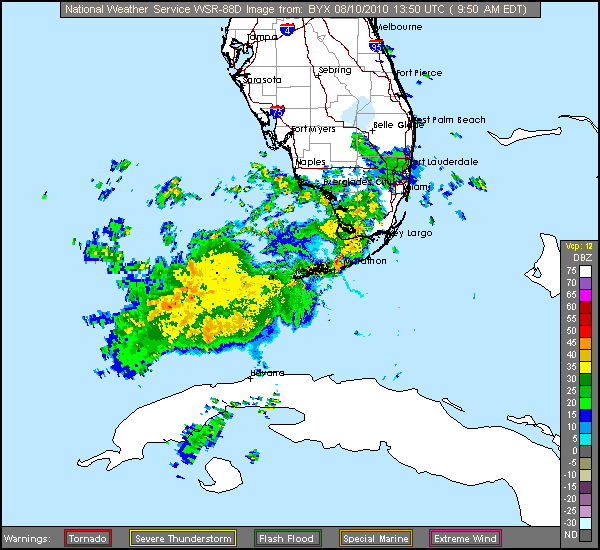
AREA FORECAST DISCUSSION FOR THE FLORIDA KEYS
NATIONAL WEATHER SERVICE KEY WEST FL
957 AM EDT TUE AUG 10 2010
.DISCUSSION...
.CURRENTLY...
IR SATELLITE INTERROGATION SHOWS A WEAK SURFACE LOW IN THE GULF OF
MEXICO ABOUT 100 MILES WEST OF NAPLES WITH AN UPPER LOW SPINNING OVER
THE CENTRAL FLORIDA EAST COAST AS INDICATED BY THIS MORNINGS WATER
VAPOR LOOP. THE EARLY VISIBLE IMAGES SHOW A CLUSTER OF CONVECTION
LOCATED FROM MAINLAND MONROE SOUTHWEST ACROSS FLORIDA BAY...THE GULF
WATERS...AND THE WESTERN FLORIDA STRAITS TO THE WESTERN TIP OF CUBA.
THE KBYX RADAR SHOWS A LINE OF SHOWERS AND THUNDERSTORMS MOVING NORTH
NORTHEAST OVER THE MIDDLE KEYS AND FLORIDA BAY TOWARD FLAMINGO...AND
A LARGE AREA OF STRATOFORM RAIN SOUTH OF THE MARQUESAS KEYS AND DRY
TORTUGAS. MORE SHOWERS AND THUNDERSTORMS ARE MOVING NORTHWESTWARD
ACROSS THE SOUTHWEST FLORIDA COAST FROM CHOKOLOSKEE TO MARCO ISLAND
AND INTO THE GULF OF MEXICO. ALL THIS ACTIVITY IS CIRCLING AROUND
THE SURFACE LOW IN THE GULF. RAINFALL AMOUNTS HAVE BEEN HOLDING IN
THE HALF INCH RANGE OVERNIGHT AND EXPECT THAT THE MIDDLE AND LOWER
KEYS WILL SEE THE BRUNT OF THE ACTIVITY TODAY. THE SOUNDING THIS
MORNING WAS INDICATING NEARLY 2.5 INCHES OF PWATS WHICH WAS VERIFIED
BY THE CUDJOE KEY PROFILER. THIS IS WELL ABOVE 2 STANDARD DEVIATIONS
FROM NORMAL AND IN THE HIGH 90 PERCENTILE OF RECORD PWAT. WINDS HAVE
INCREASED ACROSS THE ISLAND CHAIN TO NEAR 10 KNOTS AT THE TERMINALS
AND NEAR 15 KNOTS AT THE C-MAN STATIONS ALL OUT OF THE SOUTH TO
SOUTHWEST FROM THE MIDDLE KEYS WESTWARD...AND MORE SOUTH TO SOUTHEAST
ALONG THE UPPER KEYS. SHOWERS AND THUNDERSTORMS PRODUCING GUSTS TO 25
TO 30 KNOTS IN STRONGER ACTIVITY. AN OVERNIGHT ASCAT SATELLITE PASS
PRESENTATION HAD VERY GOOD LOOK AT THE LOW IN THE GULF WITH AN
OBVIOUS CIRCULATION NORTH OF THE KEYS AND WEST OF MAINLAND MONROE.
0 likes
Carla/Alicia/Jerry(In The Eye)/Michelle/Charley/Ivan/Dennis/Katrina/Rita/Wilma/Ike/Harvey
Member: National Weather Association
Wx Infinity Forums
http://wxinfinity.com/index.php
Facebook.com/WeatherInfinity
Twitter @WeatherInfinity
Member: National Weather Association
Wx Infinity Forums
http://wxinfinity.com/index.php
Facebook.com/WeatherInfinity
Twitter @WeatherInfinity

Re: ATL: INVEST 94L - Discussion
Hurakan, I agree with your center location. You can clearly see the low clouds turning CC there on the high resolution VIS SAT. So, the MLC must be the turning in the convective mass to the south. Question is, will the LLC relocate under the MLC or will the convection get tugged north into the current LLC. Hmmm...
0 likes
-
SkeetoBite

- S2K Supporter
- Posts: 515
- Age: 60
- Joined: Fri Sep 03, 2004 8:25 am
- Contact:
-
LAwxrgal

- S2K Supporter
- Posts: 1763
- Joined: Tue Jul 06, 2004 1:05 pm
- Location: Reserve, LA (30 mi west of NOLA)
This thing has my attention, most definitely, since it's forecast to landfall possibly in my back yard in 2 or 3 days.
It popped up pretty suddenly.
So, which of these storms will be Danielle and which one will be Earl?
It popped up pretty suddenly.
So, which of these storms will be Danielle and which one will be Earl?
0 likes
Andrew 92/Isidore & Lili 02/Bill 03/Katrina & Rita 05/Gustav & Ike 08/Isaac 12 (flooded my house)/Harvey 17/Barry 19/Cristobal 20/Claudette 21/Ida 21 (In the Eye)/Francine 24
Wake me up when November ends
Wake me up when November ends
Yeah I see that as well Hurakan, its elongated though which probably suggests its not quite there yet...
I suspect we need to keep an eye on the ULL, if it carries on heading westwards the shear will ease off and when that happens the convection will probably build back and thats when we will see strengthening occur.
I suspect we need to keep an eye on the ULL, if it carries on heading westwards the shear will ease off and when that happens the convection will probably build back and thats when we will see strengthening occur.
0 likes
Personal Forecast Disclaimer:
The posts in this forum are NOT official forecast and should not be used as such. They are just the opinion of the poster and may or may not be backed by sound meteorological data. They are NOT endorsed by any professional institution or storm2k.org. For official information, please refer to the NHC and NWS products
The posts in this forum are NOT official forecast and should not be used as such. They are just the opinion of the poster and may or may not be backed by sound meteorological data. They are NOT endorsed by any professional institution or storm2k.org. For official information, please refer to the NHC and NWS products
Re: ATL: INVEST 94L - Discussion
The following post is NOT an official forecast and should not be used as such. It is just the opinion of the poster and may or may not be backed by sound meteorological data. It is NOT endorsed by any professional institution including storm2k.org For Official Information please refer to the NHC and NWS products.
Here's my "first call"...I tried this with Bonnie and did pretty well, so I thought I'd give it another whirl...this time with intensity forecast, too. My forecast calls for a slow WNW movement for the next day, with slow consolidation to tropical storm status. Then a gradual acceleration to the NW and an "acceleration of strengthening" as the system nears the coast. Landfall is shown in southeastern/south central Louisiana as a Cat 1 hurricane. The faster the storm moves, the weaker it'll be at landfall.

Here's my "first call"...I tried this with Bonnie and did pretty well, so I thought I'd give it another whirl...this time with intensity forecast, too. My forecast calls for a slow WNW movement for the next day, with slow consolidation to tropical storm status. Then a gradual acceleration to the NW and an "acceleration of strengthening" as the system nears the coast. Landfall is shown in southeastern/south central Louisiana as a Cat 1 hurricane. The faster the storm moves, the weaker it'll be at landfall.
0 likes
Re: ATL: INVEST 94L - Discussion
Nice cool blustery breezes that shake the bushes and then calm down here. Nice to have that burning sun blocked for a change. No rain. Low-hanging clouds like something is forming nearby.
0 likes
-
srainhoutx
- S2K Supporter
- Posts: 6919
- Age: 68
- Joined: Sun Jan 14, 2007 11:34 am
- Location: Haywood County, NC
- Contact:
Re: ATL: INVEST 94L - Discussion

0 likes
Carla/Alicia/Jerry(In The Eye)/Michelle/Charley/Ivan/Dennis/Katrina/Rita/Wilma/Ike/Harvey
Member: National Weather Association
Wx Infinity Forums
http://wxinfinity.com/index.php
Facebook.com/WeatherInfinity
Twitter @WeatherInfinity
Member: National Weather Association
Wx Infinity Forums
http://wxinfinity.com/index.php
Facebook.com/WeatherInfinity
Twitter @WeatherInfinity
-
TeamPlayersBlue

- Category 5

- Posts: 3533
- Joined: Tue Feb 02, 2010 1:44 am
- Location: Denver/Applewood, CO
Re: ATL: INVEST 94L - Discussion
ronjon wrote:Hurakan, I agree with your center location. You can clearly see the low clouds turning CC there on the high resolution VIS SAT. So, the MLC must be the turning in the convective mass to the south. Question is, will the LLC relocate under the MLC or will the convection get tugged north into the current LLC. Hmmm...
All this will happen when the dry air dissipates in my opinion
0 likes
Personal Forecast Disclaimer:
The posts in this forum are NOT official forecast and should not be used as such. They are just the opinion of the poster and may or may not be backed by sound meteorological data. They are NOT endorsed by any professional institution or storm2k.org. For official information, please refer to the NHC and NWS products.
The posts in this forum are NOT official forecast and should not be used as such. They are just the opinion of the poster and may or may not be backed by sound meteorological data. They are NOT endorsed by any professional institution or storm2k.org. For official information, please refer to the NHC and NWS products.
Re: ATL: INVEST 94L - Discussion
Well here in Kendall(miami) its been raining off and on since this morning.. had stopped for a bit and picked up again just now.
0 likes
Re:
LAwxrgal wrote:This thing has my attention, most definitely, since it's forecast to landfall possibly in my back yard in 2 or 3 days.
It popped up pretty suddenly.
I think this one has suddenly got a lot of attention and this board will light up in the next 24hrs...
What is really interesting is the speed of which the ULL is racing westwards at the moment, its really chugging along at the moment. I reckon conditions are going to improve a little sooner then some of the models are expecting given the quick motion to the west of the ULL...the system very soon will start to get some aid from the ULL...
0 likes
Personal Forecast Disclaimer:
The posts in this forum are NOT official forecast and should not be used as such. They are just the opinion of the poster and may or may not be backed by sound meteorological data. They are NOT endorsed by any professional institution or storm2k.org. For official information, please refer to the NHC and NWS products
The posts in this forum are NOT official forecast and should not be used as such. They are just the opinion of the poster and may or may not be backed by sound meteorological data. They are NOT endorsed by any professional institution or storm2k.org. For official information, please refer to the NHC and NWS products
-
Portastorm

- Storm2k Moderator

- Posts: 9955
- Age: 63
- Joined: Fri Jul 11, 2003 9:16 am
- Location: Round Rock, TX
- Contact:
Re: ATL: INVEST 94L - Discussion
Great image there srainhoutx ... I finally "get it" with regards to the weakening of the ridge over the central Gulf coast and the projected northwest movement of 94L. Thanks!
0 likes
-
Air Force Met
- Military Met

- Posts: 4372
- Age: 57
- Joined: Tue Jul 08, 2003 9:30 am
- Location: Roan Mountain, TN
Re: ATL: INVEST 94L - Discussion
MiamiHurricanes10 wrote: The ASCAT pass from around 03z revealed a well-defined closed surface circulation, you add that up with what I'm seeing on MIMIC-TPW, and surface observations...I would say that Recon will finds a tropical depression when they head out.
I really don't see what recon is going to tell us that we don't already know. If I was calling the shots...I wouldn't send them.
The location of 94L is in a data plentiful area and given the LLC is exposed...visible imagery lets you know everything you need to know about what the circulation is doing.
There are so many buoys and ships in this part of the Gulf...recon isn't going to find anything drastically different than what we already know: The pressure is at about 1009 MB...its broad and elongated...and there are 15-20 kts of winds well north of the center...and some 20 kt winds to the south.
It is tightening up...and if it can get a good convective burst over the center later today or tonight...it will go. However...due to the amount of data out there at the sfc...recon won't find any surprises.
0 likes
Who is online
Users browsing this forum: No registered users and 44 guests