ATL : INVEST 92L - DISCUSSION

Moderator: S2k Moderators

Message
Author
Dean4Storms
S2K Supporter
S2K Supporter
Posts: 6358
Age: 62
Joined: Sun Aug 31, 2003 1:01 pm
Location: Miramar Bch. FL

Re: ATL : INVEST 92L - Discussion

#421 Postby Dean4Storms » Mon Jun 14, 2010 9:11 am

JTE50 wrote:
Blown Away wrote:
cycloneye wrote:So far this has not come yet BEGIN
NHC_ATCF
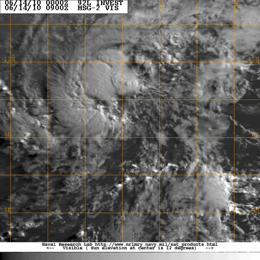
invest_RENUMBER so no TD at 11 AM,unless they quickly upgrade.I think they will wait to see if convection persists more before 5 PM.


The media is just waiting for this to happen and if it does the 5 day cone will point towards the islands and in the general direction of the GOM spill and that will create a huge news story regardless of the storms intensity predictions. I agree they will wait for persistence before pulling that trigger!


Agreed, remember if a Hurricane does enter the Gulf of Mexico and they have to seek shelter at the DeepWater Horizon site, they have to move the ships AND the cap presently over the riser pipe. It will then be free flowing 100% and who knows what will happen to the relief rig trying to intersect the present well underground if a Rita or Katrina hits it. You've seen the pictures of rigs all bent up after those Hurricanes.


I would be astounded if this system traverses from where it is currently and through the Carib. dodging the bigger islands and the shear and dry air to arrive into the Gulf as a hurricane especially it being June, the odds are highly against it IMO. Matter of fact I cannot remember a system making that long a haul in June and making it to the Gulf as a hurricane.
0 likes   

User avatar
TeamPlayersBlue
Category 5
Category 5
Posts: 3445
Joined: Tue Feb 02, 2010 1:44 am
Location: Denver/Applewood, CO

#422 Postby TeamPlayersBlue » Mon Jun 14, 2010 9:14 am

Storm lost some of its 'swagger' overnight. Looks to have pulled quite a bit to the north as well. If it continues on this track then that would be much better for the US and the GOM. If it does make it through the Leeward chain, it looked like there was some sheer just west of the islands. Still very favorable for some development. I'd expect it to be the first named storm likely by this evening
0 likes   
Personal Forecast Disclaimer:
The posts in this forum are NOT official forecast and should not be used as such. They are just the opinion of the poster and may or may not be backed by sound meteorological data. They are NOT endorsed by any professional institution or storm2k.org. For official information, please refer to the NHC and NWS products.

User avatar
HURAKAN
Professional-Met
Professional-Met
Posts: 46086
Age: 38
Joined: Thu May 20, 2004 4:34 pm
Location: Key West, FL
Contact:

#423 Postby HURAKAN » Mon Jun 14, 2010 9:18 am

0 likes   

StormClouds63
Category 2
Category 2
Posts: 583
Age: 62
Joined: Tue May 13, 2008 11:56 am
Location: Southwest Louisiana

Re: ATL : INVEST 92L - Discussion

#424 Postby StormClouds63 » Mon Jun 14, 2010 9:22 am

Just don't think this one will make it to tropical storm status. Wouldn't be surprised to see the code lowered from red to orange. Looked a lot more promising yesterday afternoon and evening. Dry air and shear await 92L. Don't think this is Alex.
0 likes   

bob rulz
Category 5
Category 5
Posts: 1704
Age: 35
Joined: Sat Jan 28, 2006 7:30 pm
Location: Salt Lake City, Utah

Re: Re:

#425 Postby bob rulz » Mon Jun 14, 2010 9:24 am

gatorcane wrote:
bob rulz wrote:Yeah there was definitely a significant size reduction! It shed a lot of the moisture envelope surrounding it.

I'm surprised that the NHC didn't increase the development chances but I don't blame them for being hesitant, given the time and location.


Not surprising at all really. Note the discussion is mentioning a timeframe for development (1-2 days). That's when the upper-level conditions are favorable. Here is in this loop you can see can really see the southeasten-edge of the TUTT (shear). Look at the high clouds on this IR loop streaming from the Leewards to off to the ENE just NW of 92L, fairly quickly. 92L is headed for that and dry air and just can't see it surviving that. It's like a wall of defense that may very well protect the Leewards and points west from anything significant out of 92L.

http://www.ssd.noaa.gov/goes/east/catl/loop-avn.html


Yeah I see what you're talking about.

I am still somewhat surprised. This seems to be on the verge of being a TD right now and there are still 2 days of favorable conditions ahead (which of course covers the entire 48 hours). It may not last for long but the lower development chances out ahead of the storm shouldn't affect its chances now.

But NHC are the experts and they won't declare it until they're certain. Not questioning their judgment, just making an observation. :wink:
0 likes   

User avatar
HURAKAN
Professional-Met
Professional-Met
Posts: 46086
Age: 38
Joined: Thu May 20, 2004 4:34 pm
Location: Key West, FL
Contact:

#426 Postby HURAKAN » Mon Jun 14, 2010 9:26 am

Jeff Masters - Link - http://www.wunderground.com/blog/JeffMa ... rynum=1506

Invest 92L, a remarkably well-developed African tropical wave for so early in the season, is midway between Africa and the Lesser Antilles Islands. Infrared satellite loops show a modest area of heavy thunderstorms along the north side of 92L's center of circulation, and the storm's heavy thunderstorms activity appears to be slowly increasing in intensity and areal coverage. Upper-level outflow is apparent to the west and north of 92L, and the outflow has been gradually improving this morning. Visible satellite loops do not show much in the way of low-level spiral bands, and my current take from the satellite imagery is that 92L is slowly organizing, and will not become a tropical depression any earlier than 11pm EDT tonight (Monday.) A 4:27 am EDT pass from the WINDSAT satellite saw a partially closed circulation at the surface (open on the south side), with top surface winds of 25 - 30 mph north of the center.

Sea surface temperatures
Climatology argues against development of 92L, since only one named storm has ever formed between Africa and the Lesser Antilles Islands in the month of June--Tropical Storm Ana of 1979 (Figure 2). However, sea surface temperatures (SSTs) underneath 92L are an extremely high 28°C, and will increase to 29°C by Thursday. In fact, with summer not even here, and three more months of heating remaining until we reach peak SSTs in the Atlantic, ocean temperatures across the entire Caribbean and waters between Africa and the Lesser Antilles are about the same as they were during the peak week for water temperatures in 2009 (mid-September.)

Dry air not a problem for 92L until Wednesday
The disturbance doesn't have to worry about dry air today or Tuesday--Total Precipitable Water (TPW) loops show a very moist plume of air accompanies 92L, and water vapor satellite loops show that the center of 92L is at least 200 - 300 miles from any substantial areas of dry air. As 92L continues to push northwest, though, the SHIPS model is predicting that relative humidity at middle levels of the atmosphere will fall from the current value of about 70%, to 60% on Wednesday. This dry air may begin to cause problems for 92L on Wednesday, especially since wind shear will be increasing at the same time. Tropical cyclones are more vulnerable to dry air when there is substantial wind shear, since the strong winds causing the shear are able to inject the dry air deep into the core of the storm.

Madden-Julian Oscillation
The 60-day cycle of enhanced thunderstorm activity called the Madden-Julian Oscillation is currently favoring upward motion over eastern tropical Atlantic, and this enhanced upward motion helps create stronger updrafts and higher chances of tropical cyclone development.

Wind shear
A major issue for 92L, like it is for most June disturbances, is wind shear. The subtropical jet stream has a branch flowing through the Caribbean and tropical Atlantic north of 10° N that is bringing 20 - 40 knots of wind shear to the region. Our disturbance was located near 10°N, 40°W at 8am EDT this morning, a few hundred miles south of this band of high shear, and is currently only experiencing 5 - 10 knots of shear. This low amount of shear should allow for some steady development of 92L over the next two days as it tracks west-northwest or northwest at 15 mph. The latest run of the SHIPS model is predicting the shear will rise to 20 knots on Wednesday, which may start to cause problems for 92L.

The forecast for 92L
The National Hurricane Center is giving 92L a high (60% chance) of developing into a tropical depression by Wednesday morning, which is a reasonable forecast. The odds of development have increased since yesterday, as the storm has moved considerably to the northwest, away from the Equator. Now it can leverage the Earth's spin to a much greater degree to help get it get spinning. It is quite unusual for a tropical depression to form south of 8°N latitude.

I expect that 92L's best chance to become a tropical depression will come on Tuesday, and the storm could strengthen enough by Wednesday to be named Tropical Storm Alex. The farther south 92L stays, the better chance it has at survival. With the system's steady west-northwest movement this week, 92L will probably begin encountering hostile wind shear in excess of 20 knots by Wednesday, which should interfere with continued development. Several of our reliable models do develop 92L into a tropical storm with 40 - 55 mph winds, but all of the models foresee weakening by Thursday or Friday as 92L approaches the Lesser Antilles Islands and encounters high shear and dry air. I doubt 92L will be anything stronger than a 45 mph tropical storm when it moves through the northern Lesser Antilles Islands on Friday and Saturday, and it would be no surprise if wind shear has destroyed the storm by then. However, as usual, surprises can happen, and the GFS and the SHIPS model (which is based upon the GFS) do indicate that more modest levels of wind shear in the 15 - 20 mph range late this week may allow 92L to stay stronger than I'm expecting. Residents of the islands--particularly the northern Lesser Antilles--should follow the progress of 92L closely, and anticipate heavy rains and high winds moving through the islands as early as Thursday night.
0 likes   

User avatar
JTE50
Category 1
Category 1
Posts: 336
Age: 67
Joined: Mon Jul 21, 2008 10:48 am
Location: Pensacola
Contact:

Re: ATL : INVEST 92L - Discussion

#427 Postby JTE50 » Mon Jun 14, 2010 9:31 am

I would be astounded if this system traverses from where it is currently and through the Carib. dodging the bigger islands and the shear and dry air to arrive into the Gulf as a hurricane especially it being June, the odds are highly against it IMO. Matter of fact I cannot remember a system making that long a haul in June and making it to the Gulf as a hurricane.[/quote]

I'm thinking down the road when it really gets busy like August and Sept. not with this system now in the Atlantic.
0 likes   

User avatar
HURAKAN
Professional-Met
Professional-Met
Posts: 46086
Age: 38
Joined: Thu May 20, 2004 4:34 pm
Location: Key West, FL
Contact:

#428 Postby HURAKAN » Mon Jun 14, 2010 9:40 am

Image

Loop
0 likes   

tolakram
Admin
Admin
Posts: 20009
Age: 62
Joined: Sun Aug 27, 2006 8:23 pm
Location: Florence, KY (name is Mark)

Re: ATL : INVEST 92L - Discussion

#429 Postby tolakram » Mon Jun 14, 2010 9:49 am

Looks like the LLC is getting better defined and might be at 12 rather than 10. NHC floater moved so a better view is possible now.
0 likes   
M a r k
- - - - -
Join us in chat: Storm2K Chatroom Invite. Android and IOS apps also available.

The posts in this forum are NOT official forecasts and should not be used as such. Posts are NOT endorsed by any professional institution or STORM2K.org. For official information and forecasts, please refer to NHC and NWS products.

User avatar
NDG
S2K Supporter
S2K Supporter
Posts: 15446
Joined: Sun Jul 09, 2006 10:14 pm
Location: Orlando, FL

Re: ATL : INVEST 92L - Discussion

#430 Postby NDG » Mon Jun 14, 2010 9:54 am

Center of circulation does appear to be further north now, closer to the 11th latitude, closer to the deeper convection.
0 likes   

User avatar
Blown Away
S2K Supporter
S2K Supporter
Posts: 10145
Joined: Wed May 26, 2004 6:17 am

Re: ATL : INVEST 92L - Discussion

#431 Postby Blown Away » Mon Jun 14, 2010 9:56 am

tolakram wrote:Looks like the LLC is getting better defined and might be at 12 rather than 10. NHC floater moved so a better view is possible now.

LOL, I zoomed in on the visible and thought I caught a glimpse of the LLC before it went back under cover.
http://www.ssd.noaa.gov/goes/flt/t1/loop-vis.html
Image
0 likes   
Hurricane Eye Experience: David 79, Irene 99, Frances 04, Jeanne 04, Wilma 05... EYE COMING MY WAY IN 2024…
Hurricane Brush Experience: Andrew 92, Erin 95, Floyd 99, Matthew 16, Irma 17, Ian 22, Nicole 22…

User avatar
cycloneye
Admin
Admin
Posts: 145308
Age: 68
Joined: Thu Oct 10, 2002 10:54 am
Location: San Juan, Puerto Rico

Re: ATL : INVEST 92L - Discussion

#432 Postby cycloneye » Mon Jun 14, 2010 10:01 am

Off Topic=For those interested in the latest update from the Climate Prediction Center weekly update,you can go to Talking Tropics forum and see the update.Breaking News=Nino 3.4 reaches La Nina Threshold.

viewtopic.php?f=31&t=92137&p=1990412#p1990412
0 likes   
Visit the Caribbean-Central America Weather Thread where you can find at first post web cams,radars
and observations from Caribbean basin members Click Here

User avatar
NDG
S2K Supporter
S2K Supporter
Posts: 15446
Joined: Sun Jul 09, 2006 10:14 pm
Location: Orlando, FL

Re: ATL : INVEST 92L - Discussion

#433 Postby NDG » Mon Jun 14, 2010 10:13 am

Blown Away wrote:
tolakram wrote:Looks like the LLC is getting better defined and might be at 12 rather than 10. NHC floater moved so a better view is possible now.

LOL, I zoomed in on the visible and thought I caught a glimpse of the LLC before it went back under cover.
http://www.ssd.noaa.gov/goes/flt/t1/loop-vis.html


Latest estimate by Navy site has 92L centered at 10.7N & 39.9W

92LINVEST.25kts-1011mb-107N-399W


Image
0 likes   

User avatar
cycloneye
Admin
Admin
Posts: 145308
Age: 68
Joined: Thu Oct 10, 2002 10:54 am
Location: San Juan, Puerto Rico

Re: ATL : INVEST 92L - Discussion

#434 Postby cycloneye » Mon Jun 14, 2010 10:17 am

Image
0 likes   
Visit the Caribbean-Central America Weather Thread where you can find at first post web cams,radars
and observations from Caribbean basin members Click Here

User avatar
cycloneye
Admin
Admin
Posts: 145308
Age: 68
Joined: Thu Oct 10, 2002 10:54 am
Location: San Juan, Puerto Rico

Re: ATL : INVEST 92L - Discussion

#435 Postby cycloneye » Mon Jun 14, 2010 10:54 am

Possible recon mission by next wednesday

NOUS42 KNHC 141600
WEATHER RECONNAISSANCE FLIGHTS
CARCAH, NATIONAL HURRICANE CENTER, MIAMI, FL.
1200 PM EDT MON 14 JUNE 2010
SUBJECT: TROPICAL CYCLONE PLAN OF THE DAY (TCPOD)
VALID 15/1100Z TO 16/1100Z JUNE 2010
TCPOD NUMBER.....10-014

I. ATLANTIC REQUIREMENTS
1. NEGATIVE RECONNAISSANCE REQUIREMENTS.
2. SUCCEEDING DAY OUTLOOK: POSSIBLE LOW LEVEL
INVEST NEAR 14N 53W AT 16/1800Z.

http://www.nhc.noaa.gov/text/MIAREPRPD.shtml?

0 likes   
Visit the Caribbean-Central America Weather Thread where you can find at first post web cams,radars
and observations from Caribbean basin members Click Here

curtadams
S2K Supporter
S2K Supporter
Posts: 1122
Joined: Sun Aug 28, 2005 7:57 pm
Location: Orange, California
Contact:

#436 Postby curtadams » Mon Jun 14, 2010 10:55 am

Looks to be losing organization to me. The convection is moving N to about 12N but the low-level center of circulation is lagging back at 10N. They don't seem to be moving in concert, as you see with sheared systems, and we're not seeing brisk LL East winds just north of convection, as you usually see with systems pulling away from the ITCZ.
0 likes   

User avatar
Ivanhater
Storm2k Moderator
Storm2k Moderator
Posts: 11161
Age: 38
Joined: Fri Jul 01, 2005 8:25 am
Location: Pensacola

Re: ATL : INVEST 92L - Discussion

#437 Postby Ivanhater » Mon Jun 14, 2010 11:06 am

Not what I expected to see this morning. I don't think the NHC will upgrade based on organization today and shear out ahead. This may have a slim shot down the road though.
0 likes   
Michael

User avatar
drezee
S2K Supporter
S2K Supporter
Posts: 3664
Joined: Mon Jun 09, 2003 12:49 pm
Location: FL

Re: ATL : INVEST 92L - Discussion

#438 Postby drezee » Mon Jun 14, 2010 11:07 am

Hey!!! I think the center went almost on top of this buoy!! 12.000 N 38.000 W

http://www.ndbc.noaa.gov/station_page.php?station=41026

Winds were 20-24 Kts the switched SSW at 8 knots once it passed. No pressure readings...

The winds alone would suggest one of three things:
1. The center is above 12N
2. The center is tilted W to NE
3. The center is trying to close or opening up right now...
0 likes   

User avatar
BigA
Professional-Met
Professional-Met
Posts: 1317
Joined: Sun Jul 24, 2005 10:56 pm

Re: ATL : INVEST 92L - Discussion

#439 Postby BigA » Mon Jun 14, 2010 11:18 am

It can survive and perhaps strengthen if it stays south of about 15 north

Current 200mb winds

URL=http://img685.imageshack.us/i/0gfs.gif/]Image[/URL]


GFS 72 hour 200mb wind forecast

Image

It looks to lessen down the road. 0Z nogaps shows the same thing. But if I had a nickle for every time that it looked like shear would lessen down the road and allow a system to strengthen, but then it didn't, I'd be a wealthy man.
0 likes   

tolakram
Admin
Admin
Posts: 20009
Age: 62
Joined: Sun Aug 27, 2006 8:23 pm
Location: Florence, KY (name is Mark)

Re: ATL : INVEST 92L - Discussion

#440 Postby tolakram » Mon Jun 14, 2010 11:18 am

It looks sheared with convection being tossed NE of the center. Looking at the visible you can see the shear ahead of it and pretty darn close. At this point I'm again starting to doubt this will make it to a TD.
0 likes   
M a r k
- - - - -
Join us in chat: Storm2K Chatroom Invite. Android and IOS apps also available.

The posts in this forum are NOT official forecasts and should not be used as such. Posts are NOT endorsed by any professional institution or STORM2K.org. For official information and forecasts, please refer to NHC and NWS products.


Return to “2010”

Who is online

Users browsing this forum: No registered users and 3 guests