

Yeah I agree stormcenter, I'm not totally sold on development for that matter but these sorts of systems do have a habit of developing in the N.Gulf from frontal boundaries.
MLC should continue WSW for a little yet, I'd imagine it'd be the area to watch though for now it looks attached to the frontal system still, hence why its non tropical according to the NHC.
ATL: INVEST 95L - DISCUSSION
Moderator: S2k Moderators
0 likes
Personal Forecast Disclaimer:
The posts in this forum are NOT official forecast and should not be used as such. They are just the opinion of the poster and may or may not be backed by sound meteorological data. They are NOT endorsed by any professional institution or storm2k.org. For official information, please refer to the NHC and NWS products
The posts in this forum are NOT official forecast and should not be used as such. They are just the opinion of the poster and may or may not be backed by sound meteorological data. They are NOT endorsed by any professional institution or storm2k.org. For official information, please refer to the NHC and NWS products
-
Stormcenter
- S2K Supporter

- Posts: 6689
- Joined: Wed Sep 03, 2003 11:27 am
- Location: Houston, TX
Here's a nice visible loop of what is going on right now.
http://www.rap.ucar.edu/weather/satelli ... uration=12
http://www.rap.ucar.edu/weather/satelli ... uration=12
0 likes


Re: ATL: INVEST 95L - DISCUSSION
MWatkins wrote:Infdidoll wrote:I don't normally watch the Atlantic much...being that I'm living in the West Pacific for now, but I just started really getting into storm-watching...Where is the biggest hot spot for storms to form in that area? Or is there one?
Since it varies by month, here is a list of the hotspots by each month based on historical frequency and past tracks. Enjoy!
http://www.nhc.noaa.gov/pastprofile.shtml#ori
MW
Thanks for posting this! Really neat info...
0 likes
-
DTWright

- Tropical Low

- Posts: 37
- Age: 66
- Joined: Sun Jun 27, 2010 4:48 pm
- Location: ( AKA Sabanic ) Mobile, AL
- Contact:
Re: ATL: INVEST 95L - DISCUSSION
Actually it is supposed to, according to some models, meander towards the WSW into the Gulf, and from there it's anyone's guess . . .
0 likes
Re:
CrazyC83 wrote:Isn't this supposed to just roll over Florida and become an east coast low?
That was the idea orginally but since then the models have come into better agreement on 95L to head W/WSW close to the Gulf states and eventually turn inland. Upper ridge looking strong now so no reason for it to turn out the NE just yet.
0 likes
Personal Forecast Disclaimer:
The posts in this forum are NOT official forecast and should not be used as such. They are just the opinion of the poster and may or may not be backed by sound meteorological data. They are NOT endorsed by any professional institution or storm2k.org. For official information, please refer to the NHC and NWS products
The posts in this forum are NOT official forecast and should not be used as such. They are just the opinion of the poster and may or may not be backed by sound meteorological data. They are NOT endorsed by any professional institution or storm2k.org. For official information, please refer to the NHC and NWS products
-
Weatherfreak000
-
TreasureIslandFLGal

- S2K Supporter
- Posts: 1584
- Age: 58
- Joined: Sun Aug 15, 2004 6:16 pm
- Location: Cancun, Mexico (northeast Yucatan coast)
I just wish it would hurry up and get outta here! As long as that and its sagging front are around, Tampa Bay will be in the clouds and rainy weather for the holiday weekend! I was really looking forward to getting out on the boat this weekend now that my back is healthy again!
0 likes
Chrissy & Ligeia

-
Frank P
- S2K Supporter
- Posts: 2779
- Joined: Fri Aug 29, 2003 10:52 am
- Location: Biloxi Beach, Ms
- Contact:
Re: ATL: INVEST 95L - DISCUSSION
mid level spin looks to be building some convection to its south, maybe working its way down and just might become the dominant spin, lots of activity and shear, who knows..
0 likes

20kts still hardly condusive for development, I suppose with enough convection left to the south of the LLC and a MLC present well displaced this has a chance as long as it doesn't race too quickly to the west.
0 likes
Personal Forecast Disclaimer:
The posts in this forum are NOT official forecast and should not be used as such. They are just the opinion of the poster and may or may not be backed by sound meteorological data. They are NOT endorsed by any professional institution or storm2k.org. For official information, please refer to the NHC and NWS products
The posts in this forum are NOT official forecast and should not be used as such. They are just the opinion of the poster and may or may not be backed by sound meteorological data. They are NOT endorsed by any professional institution or storm2k.org. For official information, please refer to the NHC and NWS products
-
Brent
- S2K Supporter
- Posts: 38777
- Age: 37
- Joined: Sun May 16, 2004 10:30 pm
- Location: Tulsa Oklahoma
- Contact:
Re: ATL: INVEST 95L - DISCUSSION
Not impressed with this mess at all, but it certainly bears watching. I'm just not bullish on much development.
0 likes
#neversummer
-
tolakram
- Admin

- Posts: 20186
- Age: 62
- Joined: Sun Aug 27, 2006 8:23 pm
- Location: Florence, KY (name is Mark)
Re: ATL: INVEST 95L - DISCUSSION
Pressures are down slightly:
http://www.ndbc.noaa.gov/station_page.php?station=42039
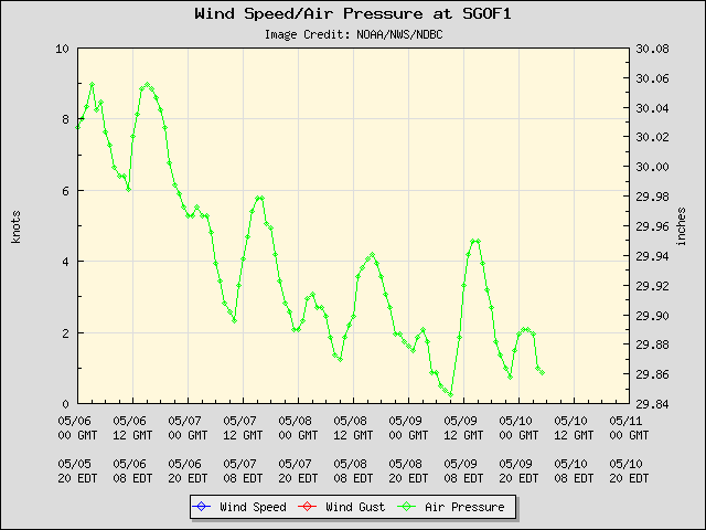
http://www.ndbc.noaa.gov/station_page.php?station=SGOF1
Sat. loop: http://wwwghcc.msfc.nasa.gov/cgi-bin/ge ... mframes=10
Low is now over water, but look at the shear. Looks more like a router cutting through wood.
http://www.ndbc.noaa.gov/station_page.php?station=42039
http://www.ndbc.noaa.gov/station_page.php?station=SGOF1
Sat. loop: http://wwwghcc.msfc.nasa.gov/cgi-bin/ge ... mframes=10
Low is now over water, but look at the shear. Looks more like a router cutting through wood.
0 likes
M a r k
- - - - -
Join us in chat: Storm2K Chatroom Invite. Android and IOS apps also available.
The posts in this forum are NOT official forecasts and should not be used as such. Posts are NOT endorsed by any professional institution or STORM2K.org. For official information and forecasts, please refer to NHC and NWS products.

Re: ATL: INVEST 95L - DISCUSSION
[quote]Not impressed with this mess at all, but it certainly bears watching. I'm just not bullish on much development[/quote]
Me either...I don't see it being much more than a nuisance for someone. I has been a very pleasant day here in PC...first dry day all week long. Nice breeze w / cloudy to mostly cloudy skies. Really looking forward to a nice Holiday weekend.
Me either...I don't see it being much more than a nuisance for someone. I has been a very pleasant day here in PC...first dry day all week long. Nice breeze w / cloudy to mostly cloudy skies. Really looking forward to a nice Holiday weekend.
0 likes
-
Ikester
- Professional-Met

- Posts: 361
- Age: 40
- Joined: Mon Jun 21, 2010 5:00 pm
- Location: Jacksonville, FL
Re: ATL: INVEST 95L - DISCUSSION
Frank P wrote:mid level spin looks to be building some convection to its south, maybe working its way down and just might become the dominant spin, lots of activity and shear, who knows..
As I have posted before, if you stir the top of a cup long enough, eventually the circulation makes its way to the bottom. If the mid-level swirl spins for a while, I'd DEFINITELY watch for this. Our futurecast here at the station spun something up last night. I remember Humberto so it ain't out of the question...pardon the slang. Okay, back to work. (this was my lunch break)
0 likes


-
JonathanBelles
- Professional-Met
- Posts: 11430
- Age: 35
- Joined: Sat Dec 24, 2005 9:00 pm
- Location: School: Florida State University (Tallahassee, FL) Home: St. Petersburg, Florida
- Contact:
-
HURAKAN

- Professional-Met
- Posts: 46084
- Age: 39
- Joined: Thu May 20, 2004 4:34 pm
- Location: Key West, FL
- Contact:
Re:
fact789 wrote:With Alex's Fringe Effects and now newly declared invest 95L in the northern Gulf, my pool temperature went from 93 last week to 80 today. Currently sitting at 80 degrees outside in a dry spot.
I just read that in facebook!!! LOL
0 likes
Who is online
Users browsing this forum: No registered users and 44 guests