WPAC: FANAPI - Tropical Depression (1011/12W/Inday)

Moderator: S2k Moderators

Message
Author
ResidentOfTaiwan
Tropical Low
Tropical Low
Posts: 15
Joined: Sat Sep 18, 2010 6:08 am
Location: Taipei, Taiwan, in the city center near 101

Re: WPAC: FANAPI - Typhoon (1011/12W/Inday)

#221 Postby ResidentOfTaiwan » Sat Sep 18, 2010 1:24 pm

Infdidoll wrote:I posted the link to your midnight update over on the Taiwan site. Hopefully that will help ease a few minds so they won't feel completely in the dark. Someone over there said it was very calm, right now, with hardly any wind yet.

I saw that. We totally appreciate it. Anyone else is welcome to come over there with any info, but I suspect you have a lot of lurkers here already.
It's starting to move a bit in Taipei right now. I just went outside and looked at the sky. The clouds were totally still half an hour ago, but now they are moving at a decent clip in a northeast to southwest direction. The trees aren't still but we don't have typhoon winds yet on the ground.
I'm so glad you were able to register, ddoll! Anyone else is welcome to register there to, I presume. We are all grateful for the info you are giving us, so if anyone else wants to come over and ask questions, I'm sure the mods would see the wisdom of that.
I'm stocked up on food and water to last through Tuesday.

I feel selfish asking this after Morakot, but lots of us in taipei would like to know if it's likely that they will close down work on Monday. BTW, In Taiwan the governement will simply announce that businesses and schools are to be closed. This is to keep employers from telling their employees to come in and do work on a day when it would be dangerous to go outside. Nice policy if I may say so.

Thanks to all of you! I am grateful, and will give you more Taipei updates as it gets closer to us.

edit: I finally got my time preferences right. It is 2:29 a.m. in Taipei as I am writing this.
0 likes   

supercane
S2K Supporter
S2K Supporter
Posts: 2856
Joined: Wed Sep 16, 2009 8:27 pm

#222 Postby supercane » Sat Sep 18, 2010 1:31 pm

Latest ASCAT:
Image

Latest microwave:
Image

Latest Dvoraks: KNES (SAB) 6.0, RJTD (JMA) 5.5, PGTW (JTWC) 5.0
761
TCNA21 RJTD 181800
CCAA 18180 47644 FANAPI(1011) 14240 11231 12334 255// 92811=

TPPN10 PGTW 181819
A. TYPHOON 12W (FANAPI)
B. 18/1732Z
C. 23.9N
D. 123.2E
E. THREE/MTSAT
F. T5.0/5.0/S0.0/24HRS STT: S0.0/06HRS
G. IR/EIR
H. REMARKS: 09A/PBO RAGGED EYE/ANMTN. 30NM RAGGED OW EYE WITH LG
SURR YIELDS A DT OF 5.0. MET AND PT AGREE. DBO DT.
I. ADDITIONAL POSITIONS:
18/1315Z 23.9N 124.1E MMHS
18/1325Z 23.8N 124.0E TRMM
GATES

TXPN27 KNES 181530
SIMWIR
A. 12W (FANAPI)
B. 18/1432Z
C. 23.9N
D. 123.7E
E. ONE/MTSAT
F. T6.0/6.0/D1.0/24HRS
G. IR/EIR/AMSU
H. REMARKS...DT IS A 5.5 WITH OW EYE EMBEDDED IN LG WITH A SURROUNDING
RING OF B. DT COULD POTENTIALLY BE A 6.5 BASED ON A FEW MORE PIXELS
OF BLACK IN A SMALL AREA OF THE CIRCULATION AND/OR 1 DEG C WARMER EYE
TEMPERATURE. MET IS 6.0 AND PT AGREES. FT BASED ON MET/PT.
I. ADDL POSITIONS
18/1041Z 24.0N 124.5E AMSU
18/1315Z 23.9N 124.1E AMSU
...JANKOT
=

Recon out flying now.
0 likes   

ResidentOfTaiwan
Tropical Low
Tropical Low
Posts: 15
Joined: Sat Sep 18, 2010 6:08 am
Location: Taipei, Taiwan, in the city center near 101

Re: WPAC: FANAPI - Typhoon (1011/12W/Inday)

#223 Postby ResidentOfTaiwan » Sat Sep 18, 2010 1:52 pm

RobWESTPACWX wrote:Thanks for posting over posting over there, nice to get a liaison between the two sites. I hope all their stay safe and the info we give them really helps.

On that note, I really am off for the night.


It HAS helped. I put your first video on there yesterday evening, and as a result, a lot of people went out and stocked up on supplies.
Now that I know Taipei is getting a direct hit, I'm going to do just one last snack and beverage run just do make sure I really don't have to leave for anything until Tuesday night. (I'm in the city, there is a 7-11 downstairs)
And I messaged some of my friends who live a further distance from grocery stores yesterday evening and told them to get stocked up.
I am grateful and you have helped us already. We didn't think Taipei would be affected as of yesterday afternoon. How quickly a situation can change.
0 likes   

supercane
S2K Supporter
S2K Supporter
Posts: 2856
Joined: Wed Sep 16, 2009 8:27 pm

#224 Postby supercane » Sat Sep 18, 2010 1:57 pm

WTPQ20 RJTD 181800
RSMC TROPICAL CYCLONE ADVISORY
NAME TY 1011 FANAPI (1011)
ANALYSIS
PSTN 181800UTC 24.0N 123.1E GOOD
MOVE W 10KT
PRES 935HPA
MXWD 095KT
GUST 135KT
50KT 90NM
30KT 180NM NORTHEAST 150NM SOUTHWEST
FORECAST
24HF 191800UTC 23.5N 118.5E 85NM 70%
MOVE WSW 10KT
PRES 975HPA
MXWD 060KT
GUST 085KT
48HF 201800UTC 23.4N 113.4E 140NM 70%
MOVE W 12KT
PRES 998HPA
MXWD 035KT
GUST 050KT
72HF 211800UTC 23.5N 108.1E 210NM 70% TROPICAL DEPRESSION =

Image

Conditions at: ROIG observed 18 September 2010 10:00 UTC
Temperature: 26.0°C (79°F)
Dewpoint: 25.0°C (77°F) [RH = 94%]
Pressure (altimeter): 28.97 inches Hg (981.0 mb)
Winds: from the NNE (20 degrees) at 47 MPH (41 knots; 21.3 m/s)
gusting to 64 MPH (56 knots; 29.1 m/s)
Visibility: 1.86 miles (2.99 km)
Ceiling: 1200 feet AGL
Clouds: few clouds at 800 feet AGL
broken clouds at 1200 feet AGL
few clouds at 2500 feet AGL
Present Weather: -SHRA (light rain showers)
ROIG 181000Z 02041G56KT 3000 -SHRA FEW008 BKN012 FEW025CB 26/25 Q0981

Image
0 likes   

User avatar
alan1961
Category 2
Category 2
Posts: 767
Joined: Mon Mar 20, 2006 11:58 am
Location: Derby, Derbyshire, England
Contact:

Re: WPAC: FANAPI - Typhoon (1011/12W/Inday)

#225 Postby alan1961 » Sat Sep 18, 2010 2:02 pm

News updates on the hour.

http://english.cntv.cn/live/
0 likes   

ResidentOfTaiwan
Tropical Low
Tropical Low
Posts: 15
Joined: Sat Sep 18, 2010 6:08 am
Location: Taipei, Taiwan, in the city center near 101

Re: WPAC: FANAPI - Typhoon (1011/12W/Inday)

#226 Postby ResidentOfTaiwan » Sat Sep 18, 2010 2:22 pm

I just got back from 7-11. On the way back there were large, dry leaves on the ground just lying there, no wind on the ground at all.
When I got back, this had been posted on the foreigner forum about 3:10 by someone who lives just outside of Taipei City:
The for rent sign of the house above mine just blew off. Been trying to seal up the side of an old air-con.(the big gap between the ac and the wall) Ended up cutting a plastic board , taking some screws out of the face of the AC and screwing it back it to hold the board. har har...let's see if it holds. Dogs are annoying!!! All of them follow me up and down the stairs allll the time, they know something is up.

edit: and this, posted at 3:30 a.m Taiwan time from someone on the southern edge or Taipei city:
The wind is really picking up here. I just heard something blow into something else... if I had to guess, it was a sign into a windshield... it had that kind of glass-breaking sound. Bummer, because this is just getting started.

I really should go to bed, but I can't imagine sleeping. I am going to go lay down at least...


And as I type this, the wind is just beginning to howl here in the center of Taipei. I got back from my snack run just in time. Thanks to all of you, I am now barricaded in until this thing is over with all of the snacks and supplies I need.
:team:

THANK YOU!!!!

edit: 3:51 p.m. The rain just started with a vengeance. I'm going to lay down now. See you in the morning!
Last edited by ResidentOfTaiwan on Sat Sep 18, 2010 2:52 pm, edited 1 time in total.
0 likes   

User avatar
alan1961
Category 2
Category 2
Posts: 767
Joined: Mon Mar 20, 2006 11:58 am
Location: Derby, Derbyshire, England
Contact:

Re: WPAC: FANAPI - Typhoon (1011/12W/Inday)

#227 Postby alan1961 » Sat Sep 18, 2010 2:49 pm

Image
Image
0 likes   

supercane
S2K Supporter
S2K Supporter
Posts: 2856
Joined: Wed Sep 16, 2009 8:27 pm

#228 Postby supercane » Sat Sep 18, 2010 4:06 pm

WTPN31 PGTW 182100
MSGID/GENADMIN/NAVMARFCSTCEN PEARL HARBOR HI/JTWC//
SUBJ/TROPICAL CYCLONE WARNING//
RMKS/
1. TYPHOON 12W (FANAPI) WARNING NR 017
01 ACTIVE TROPICAL CYCLONE IN NORTHWESTPAC
MAX SUSTAINED WINDS BASED ON ONE-MINUTE AVERAGE
WIND RADII VALID OVER OPEN WATER ONLY
---
WARNING POSITION:
181800Z --- NEAR 24.0N 123.1E
MOVEMENT PAST SIX HOURS - 275 DEGREES AT 10 KTS
POSITION ACCURATE TO WITHIN 020 NM
POSITION BASED ON EYE FIXED BY SATELLITE
PRESENT WIND DISTRIBUTION:
MAX SUSTAINED WINDS - 105 KT, GUSTS 130 KT
WIND RADII VALID OVER OPEN WATER ONLY
RADIUS OF 064 KT WINDS - 035 NM NORTHEAST QUADRANT
035 NM SOUTHEAST QUADRANT
030 NM SOUTHWEST QUADRANT
035 NM NORTHWEST QUADRANT
RADIUS OF 050 KT WINDS - 065 NM NORTHEAST QUADRANT
065 NM SOUTHEAST QUADRANT
050 NM SOUTHWEST QUADRANT
050 NM NORTHWEST QUADRANT
RADIUS OF 034 KT WINDS - 150 NM NORTHEAST QUADRANT
150 NM SOUTHEAST QUADRANT
120 NM SOUTHWEST QUADRANT
100 NM NORTHWEST QUADRANT
REPEAT POSIT: 24.0N 123.1E
---
FORECASTS:
12 HRS, VALID AT:
190600Z --- 23.9N 120.8E
MAX SUSTAINED WINDS - 090 KT, GUSTS 110 KT
WIND RADII VALID OVER OPEN WATER ONLY
RADIUS OF 064 KT WINDS - 030 NM NORTHEAST QUADRANT
030 NM SOUTHEAST QUADRANT
025 NM SOUTHWEST QUADRANT
030 NM NORTHWEST QUADRANT
RADIUS OF 050 KT WINDS - 060 NM NORTHEAST QUADRANT
060 NM SOUTHEAST QUADRANT
050 NM SOUTHWEST QUADRANT
050 NM NORTHWEST QUADRANT
RADIUS OF 034 KT WINDS - 145 NM NORTHEAST QUADRANT
140 NM SOUTHEAST QUADRANT
125 NM SOUTHWEST QUADRANT
110 NM NORTHWEST QUADRANT
VECTOR TO 24 HR POSIT: 270 DEG/ 11 KTS
---
24 HRS, VALID AT:
191800Z --- 23.9N 118.3E
MAX SUSTAINED WINDS - 075 KT, GUSTS 090 KT
WIND RADII VALID OVER OPEN WATER ONLY
RADIUS OF 064 KT WINDS - 020 NM NORTHEAST QUADRANT
020 NM SOUTHEAST QUADRANT
020 NM SOUTHWEST QUADRANT
020 NM NORTHWEST QUADRANT
RADIUS OF 050 KT WINDS - 050 NM NORTHEAST QUADRANT
050 NM SOUTHEAST QUADRANT
040 NM SOUTHWEST QUADRANT
045 NM NORTHWEST QUADRANT
RADIUS OF 034 KT WINDS - 135 NM NORTHEAST QUADRANT
130 NM SOUTHEAST QUADRANT
115 NM SOUTHWEST QUADRANT
110 NM NORTHWEST QUADRANT
VECTOR TO 36 HR POSIT: 275 DEG/ 12 KTS
---
36 HRS, VALID AT:
200600Z --- 24.0N 115.7E
MAX SUSTAINED WINDS - 050 KT, GUSTS 065 KT
WIND RADII VALID OVER OPEN WATER ONLY
DISSIPATING AS A SIGNIFICANT TROPICAL CYCLONE OVER LAND
VECTOR TO 48 HR POSIT: 280 DEG/ 11 KTS
---
EXTENDED OUTLOOK:
48 HRS, VALID AT:
201800Z --- 24.3N 113.3E
MAX SUSTAINED WINDS - 035 KT, GUSTS 045 KT
WIND RADII VALID OVER OPEN WATER ONLY
DISSIPATING AS A SIGNIFICANT TROPICAL CYCLONE OVER LAND
VECTOR TO 72 HR POSIT: 280 DEG/ 08 KTS
---
72 HRS, VALID AT:
211800Z --- 24.7N 109.9E
MAX SUSTAINED WINDS - 020 KT, GUSTS 030 KT
WIND RADII VALID OVER OPEN WATER ONLY
DISSIPATED AS A SIGNIFICANT TROPICAL CYCLONE OVER LAND
---
REMARKS:
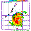
182100Z POSITION NEAR 24.0N 122.5E.
TYPHOON (TY) 12W (FANAPI), LOCATED APPROXIMATELY 105 NM SOUTHEAST OF
TAIPEI, TAIWAN, HAS TRACKED WESTWARD AT 10 KNOTS OVER THE PAST SIX
HOURS. ANIMATED INFRARED SATELLITE IMAGERY AND A 181325Z TRMM
MICROWAVE IMAGE SHOW A 30NM EYE WITH MULTIPLE DEEP CONVECTIVE BANDS
ALONG THE SOUTHERN SEMI-CIRCLE. THERE IS HIGH CONFIDENCE IN THE
INITIAL POSITION, WHICH IS BASED ON AN EYE FIX AND A TAIWAN RADAR
FIX. THE INITIAL INTENSITY IS BASED ON PGTW, KNES, AND RJTD DVORAK
ESTIMATES RANGING FROM 90 TO 115 KNOTS. THERE IS FAIR CONFIDENCE IN
THE WIND RADII STRUCTURE BASED ON A 181318Z ASCAT PASS. ANIMATED
WATER VAPOR IMAGERY CONTINUES TO SHOW EXCELLENT EQUATORWARD OUTFLOW,
HOWEVER POLEWARD OUTFLOW IS SOMEWHAT HINDERED BY AN ANTICYCLONE
NORTH OF THE SYSTEM CAUSING INCREASED NORTHEASTERLY VERTICAL WIND
SHEAR. TY 12W IS CURRENTLY TRACKING ALONG THE SOUTHERN PERIPHERY OF
A SUBTROPICAL STEERING RIDGE ANCHORED OVER NORTHEASTERN CHINA. TY
FANAPI IS FORECAST TO CONTINUE TRACKING WESTWARD THROUGHOUT THE
FORECAST PERIOD AND SHOULD MAKE LANDFALL OVER TAIWAN WITHIN THE NEXT
12 HOURS. AFTER TAU 24, TY 12W IS EXPECTED TO MAKE LANDFALL AGAIN
OVER CHINA, WEAKEN RAPIDLY, AND DISSIPATE AS A SIGNIFICANT TROPICAL
CYCLONE BY TAU 72. NUMERICAL MODEL GUIDANCE REMAINS TIGHTLY PACKED
THROUGHOUT THE FORECAST PERIOD. THEREFORE, THIS FORECAST IS IN GOOD
AGREEMENT WITH MODEL CONSENSUS. MAXIMUM SIGNIFICANT WAVE HEIGHT AT
181800Z IS 28 FEET. NEXT WARNINGS AT 190300Z, 190900Z, 191500Z AND
192100Z.//

Image

07fW40181
WTCI RCTP 181800 =
WARNING VALID 191800Z =
WARNING IS UPDATED EVERY 3 HOURS =
TYPHOON 201011 (FANAPI 201011) WARNING =
POSITION 181800Z AT TWO FOUR POINT ZERO NORTH ( 24.0N ) ONE TWO THREE POINT ONE EAST ( 123.1E ) =
MOVEMENT NEXT 24HRS WEST 20KM/HR
MIN SURFACE PRESSURE 950 HPA =
MAX SUSTAINED WINDS NEAR CENTER 43 METER PER SECOND GUST 53 METER PER SECOND =
RADIUS OF OVER 15M/S WINDS 200 KM =
FORECAST POSITION =
12HRS VALID AT 190600Z AT TWO THREE POINT NINE NORTH ( 23.9N ) ONE TWO ZERO POINT SEVEN EAST ( 120.7E )=
24HRS VALID AT 191800Z AT TWO FOUR POINT ONE NORTH ( 24.1N ) ONE ONE EIGHT POINT THREE EAST ( 118.3E )=
48HRS VALID AT 201800Z AT TWO FIVE POINT ZERO NORTH ( 25.0N ) ONE ONE FOUR POINT FOUR EAST ( 114.4E )=
72HRS VALID AT 211800Z AT TWO SIX POINT TWO NORTH ( 26.2N ) ONE ONE ZERO POINT NINE EAST ( 110.9E )=
0 likes   

phwxenthusiast
Category 2
Category 2
Posts: 637
Joined: Wed Mar 24, 2010 3:10 am
Location: Holbrook, NY (Long Island)

#229 Postby phwxenthusiast » Sat Sep 18, 2010 4:12 pm

i guess 105kts is the peak... still the strongest this year, nevertheless
0 likes   

User avatar
alan1961
Category 2
Category 2
Posts: 767
Joined: Mon Mar 20, 2006 11:58 am
Location: Derby, Derbyshire, England
Contact:

Re: WPAC: FANAPI - Typhoon (1011/12W/Inday)

#230 Postby alan1961 » Sat Sep 18, 2010 4:31 pm

Live streaming webcams for Taiwan, select area and spot at top left

http://twcam.www.gov.tw/webcam/english/ ... n.jsp?who=
0 likes   

User avatar
HURAKAN
Professional-Met
Professional-Met
Posts: 46086
Age: 37
Joined: Thu May 20, 2004 4:34 pm
Location: Key West, FL
Contact:

#231 Postby HURAKAN » Sat Sep 18, 2010 4:56 pm

Image

closer to landfall
0 likes   

RobWESTPACWX
WestPACMet
WestPACMet
Posts: 1616
Joined: Fri Sep 17, 2010 2:26 am
Location: Tokyo, Japan
Contact:

Re: WPAC: FANAPI - Typhoon (1011/12W/Inday)

#232 Postby RobWESTPACWX » Sat Sep 18, 2010 6:13 pm

Wow, gust to 90 kts sustained in Hualien
0 likes   
Satellites, Charts and Forecasting tools for East Asia at WESTERNPACIFICWEATHER.COM

User avatar
Infdidoll
Category 2
Category 2
Posts: 667
Age: 46
Joined: Thu Oct 01, 2009 8:39 pm
Location: Temecula, CA

Re: WPAC: FANAPI - Typhoon (1011/12W/Inday)

#233 Postby Infdidoll » Sat Sep 18, 2010 6:44 pm

Yeah, a few people from the Hualien area were posting on the Taiwan board that it was scary there. Looks to me on radar that the eye will pass over that area very soon. The eye is also starting to look very convected.
0 likes   

TaiwanGuest
Tropical Low
Tropical Low
Posts: 11
Joined: Sat Sep 18, 2010 7:00 am

#234 Postby TaiwanGuest » Sat Sep 18, 2010 6:56 pm

Hey. Had to turn in last night. Was woken a couple times here in the south by things banging around and big claps of thunder. Looks like the awning on the neighbor's house is like to blow off. I'm on the 12th floor, all doors to outside closed this morning and still the draft being pulled through the house is like a fan blowing on high. Some rain, but not steady. Very gusty gusts. I was hoping to get to seven eleven across the street . . . I wonder if I should chance that or not.
0 likes   

RobWESTPACWX
WestPACMet
WestPACMet
Posts: 1616
Joined: Fri Sep 17, 2010 2:26 am
Location: Tokyo, Japan
Contact:

Re: WPAC: FANAPI - Typhoon (1011/12W/Inday)

#235 Postby RobWESTPACWX » Sat Sep 18, 2010 6:59 pm

Just posted a new video at western pacific weather

Good news is (if there is good news) should start to see a decrease in intensity now. Bad new is it got stronger than originally forecasted and should still see a typhoon in the straits.
Image


Image
0 likes   
Satellites, Charts and Forecasting tools for East Asia at WESTERNPACIFICWEATHER.COM

RobWESTPACWX
WestPACMet
WestPACMet
Posts: 1616
Joined: Fri Sep 17, 2010 2:26 am
Location: Tokyo, Japan
Contact:

#236 Postby RobWESTPACWX » Sat Sep 18, 2010 7:00 pm

Is the seven eleven even open? If so wow, they really are dedicated!
0 likes   
Satellites, Charts and Forecasting tools for East Asia at WESTERNPACIFICWEATHER.COM

User avatar
Infdidoll
Category 2
Category 2
Posts: 667
Age: 46
Joined: Thu Oct 01, 2009 8:39 pm
Location: Temecula, CA

Re: WPAC: FANAPI - Typhoon (1011/12W/Inday)

#237 Postby Infdidoll » Sat Sep 18, 2010 7:01 pm

Any pro mets have any reasoning about the track? I know some in Taipei are wondering if they are going to be spared the worst of this after all. From radar, it appears the eye should be passing over Hualian (or is it Hualien? Two different spellings out there) at any time now. Does it look to anyone else that this is going to continue a little slightly more southwest?
0 likes   

RobWESTPACWX
WestPACMet
WestPACMet
Posts: 1616
Joined: Fri Sep 17, 2010 2:26 am
Location: Tokyo, Japan
Contact:

#238 Postby RobWESTPACWX » Sat Sep 18, 2010 7:08 pm

I noticed that as well, actually mentioned it on my last video. We saw EWRC last night that may have had something to do with its slight movement to the S. Otherwise did notice the ridge build a little more to the N. Could have moved it south a few miles.

My thoughts on it anyhow....
0 likes   
Satellites, Charts and Forecasting tools for East Asia at WESTERNPACIFICWEATHER.COM

User avatar
Simone Lussardi
Tropical Low
Tropical Low
Posts: 24
Age: 48
Joined: Sat Sep 11, 2004 12:00 am
Location: Foshan, Guangdong, China

Re: WPAC: FANAPI - Typhoon (1011/12W/Inday)

#239 Postby Simone Lussardi » Sat Sep 18, 2010 7:14 pm

Infdidoll wrote:Any pro mets have any reasoning about the track? I know some in Taipei are wondering if they are going to be spared the worst of this after all. From radar, it appears the eye should be passing over Hualian (or is it Hualien? Two different spellings out there) at any time now. Does it look to anyone else that this is going to continue a little slightly more southwest?


It is going to track WSW to SW across Taiwan, Taipei will most likely be spared. This is a usual land effect induced on strong storms crossing Taiwan. Usually the low level center reforms SW of where it was landed for Typhoons that are moving west, while it reforms NW of the landfall location for WNW moving storms.

Moreover, JMA forecast a SW drift while in the strait, which may give enough time to re-organize a bit before smashing into the coast of SE China, at this point I am in danger as well, because it is forecast to pass over my head (JMA, HKO) at borderline TS/TY strength... :double:

EDIT: sorry I am not a pro-met, just gave my 2 cents based on experience.
0 likes   

User avatar
Infdidoll
Category 2
Category 2
Posts: 667
Age: 46
Joined: Thu Oct 01, 2009 8:39 pm
Location: Temecula, CA

Re: WPAC: FANAPI - Typhoon (1011/12W/Inday)

#240 Postby Infdidoll » Sat Sep 18, 2010 7:16 pm

Looks like the eye will be making landfall somewhere between Shoungfou and a place called Shih T'i Pi Canyon if you are looking on Google Earth and assimilating between that and the radar.
0 likes   


Return to “2010”

Who is online

Users browsing this forum: No registered users and 12 guests