ATL: EX-Tropical Depression FIVE - Discussion
Moderator: S2k Moderators

Should become a TD again I suspect but yeah unless the convection to the south provides a real surprise we will likely see this peak at a TD...
0 likes
Personal Forecast Disclaimer:
The posts in this forum are NOT official forecast and should not be used as such. They are just the opinion of the poster and may or may not be backed by sound meteorological data. They are NOT endorsed by any professional institution or storm2k.org. For official information, please refer to the NHC and NWS products
The posts in this forum are NOT official forecast and should not be used as such. They are just the opinion of the poster and may or may not be backed by sound meteorological data. They are NOT endorsed by any professional institution or storm2k.org. For official information, please refer to the NHC and NWS products
-
ColinDelia

- S2K Supporter

- Posts: 918
- Joined: Mon Aug 29, 2005 5:52 am
- Location: The Beach, FL
-
srainhoutx

- S2K Supporter
- Posts: 6919
- Age: 68
- Joined: Sun Jan 14, 2007 11:34 am
- Location: Haywood County, NC
- Contact:
Re: ATL: EX-Tropical Depression FIVE - Discussion
Latest...
0 likes
Carla/Alicia/Jerry(In The Eye)/Michelle/Charley/Ivan/Dennis/Katrina/Rita/Wilma/Ike/Harvey
Member: National Weather Association
Wx Infinity Forums
http://wxinfinity.com/index.php
Facebook.com/WeatherInfinity
Twitter @WeatherInfinity
Member: National Weather Association
Wx Infinity Forums
http://wxinfinity.com/index.php
Facebook.com/WeatherInfinity
Twitter @WeatherInfinity
-
cycloneye

- Admin

- Posts: 149682
- Age: 69
- Joined: Thu Oct 10, 2002 10:54 am
- Location: San Juan, Puerto Rico
Re: ATL: EX-Tropical Depression FIVE - Discussion
TROPICAL WEATHER OUTLOOK
NWS TPC/NATIONAL HURRICANE CENTER MIAMI FL
200 PM EDT MON AUG 16 2010
FOR THE NORTH ATLANTIC...CARIBBEAN SEA AND THE GULF OF MEXICO...
AN AREA OF LOW PRESSURE...THE REMNANT OF TROPICAL DEPRESSION
FIVE...IS LOCATED ABOUT 100 MILES SOUTH OF THE WESTERN FLORIDA
PANHANDLE...AND HAS CHANGED LITTLE IN ORGANIZATION SINCE EARLIER
TODAY. ENVIRONMENTAL CONDITIONS ARE FORECAST TO BE MARGINALLY
CONDUCIVE FOR DEVELOPMENT OF THIS LOW AS IT MOVES GENERALLY
WESTWARD AND THEN WEST-NORTHWESTWARD OVER THE NORTHERN GULF OF
MEXICO DURING THE NEXT DAY OR SO. THERE IS A HIGH CHANCE...60
PERCENT...OF THIS SYSTEM BECOMING A TROPICAL CYCLONE BEFORE MOVING
INLAND OVER THE NORTHERN GULF COAST. AN AIR FORCE RESERVE UNIT
RECONNAISSANCE AIRCRAFT IS CURRENTLY INVESTIGATING THE SYSTEM.
LOCALLY HEAVY RAINFALL AND GUSTY WINDS ARE POSSIBLE ALONG PORTIONS
OF THE NORTH CENTRAL GULF OF MEXICO COAST THROUGH TUESDAY. SEE
STATEMENTS FROM LOCAL NATIONAL WEATHER SERVICE FORECAST OFFICES FOR
ADDITIONAL INFORMATION.
ELSEWHERE...TROPICAL CYCLONE FORMATION IS NOT EXPECTED DURING THE
NEXT 48 HOURS.
$$
FORECASTER PASCH/KIMBERLAIN
0 likes
Visit the Caribbean-Central America Weather Thread where you can find at first post web cams,radars
and observations from Caribbean basin members Click Here
and observations from Caribbean basin members Click Here
-
hurricaneCW
- Category 5

- Posts: 1799
- Joined: Wed Mar 03, 2010 6:20 am
- Location: Toms River, NJ
Re: ATL: EX-Tropical Depression FIVE - Discussion
When we all thought it would be in a great environment to strengthen, it has now become unfavorable. All that TS talk to quickly going down the drain with this one. Just another reminder of how the season has been so far. 2010 is the year of the ULL's and Shear.
0 likes
-
Stormcenter
- S2K Supporter
- Posts: 6689
- Joined: Wed Sep 03, 2003 11:27 am
- Location: Houston, TX
-
Aric Dunn
- Category 5
- Posts: 21238
- Age: 43
- Joined: Sun Sep 19, 2004 9:58 pm
- Location: Ready for the Chase.
- Contact:
Re:
HurrMark wrote:I have seen systems that were initiated that looked worse than this. I think it is probably a 30-35 mph TD. Chances that it will become a TS might be slightly lower on my end...maybe 50-50.
I agree it could technically be a TD but I have been looking hard to find a observation that is higher than 25mph even in the deepest convection... the pressure have risen and nothing points towards and more organization than what has occurred over night. The shear is just too much for this little system.. the shear axis is so close that any shifting of the upper high farther south would put the system in a much improved upper environment. The increased divergence aloft will help maintain some of the convection maybe long enough to get it in a better position in about 6 to 12 hours.
0 likes
Note: If I make a post that is brief. Please refer back to previous posts for the analysis or reasoning. I do not re-write/qoute what my initial post said each time.
If there is nothing before... then just ask
Space & Atmospheric Physicist, Embry-Riddle Aeronautical University,
I believe the sky is falling...
If there is nothing before... then just ask
Space & Atmospheric Physicist, Embry-Riddle Aeronautical University,
I believe the sky is falling...
-
DTWright

- Tropical Low

- Posts: 37
- Age: 66
- Joined: Sun Jun 27, 2010 4:48 pm
- Location: ( AKA Sabanic ) Mobile, AL
- Contact:
Re: ATL: EX-Tropical Depression FIVE - Discussion
They are still though saying there is a high chance of it becoming a TS before landfall so the fat lady ain't sang yet . . .
0 likes
-
Stormcenter
- S2K Supporter
- Posts: 6689
- Joined: Wed Sep 03, 2003 11:27 am
- Location: Houston, TX
Re: ATL: EX-Tropical Depression FIVE - Discussion
The thing is I don't see this changing for the forseeable future.
I mean honestly there is nothing out there right now except for
Ex-TD5 that may threaten the U.S. mainland for at least the next 10
days. IMO
I mean honestly there is nothing out there right now except for
Ex-TD5 that may threaten the U.S. mainland for at least the next 10
days. IMO
hurricaneCW wrote:When we all thought it would be in a great environment to strengthen, it has now become unfavorable. All that TS talk to quickly going down the drain with this one. Just another reminder of how the season has been so far. 2010 is the year of the ULL's and Shear.
0 likes
-
Stormcenter
- S2K Supporter
- Posts: 6689
- Joined: Wed Sep 03, 2003 11:27 am
- Location: Houston, TX
Re: ATL: EX-Tropical Depression FIVE - Discussion
I would agree with that 100%.
It really won't take much to make this a TD.
We've all seen many "sheared" systems still
classified a TD in that passed.
It really won't take much to make this a TD.
We've all seen many "sheared" systems still
classified a TD in that passed.
DTWright wrote:They are still though saying there is a high chance of it becoming a TS before landfall so the fat lady ain't sang yet . . .
0 likes
Re: ATL: EX-Tropical Depression FIVE - Discussion
hurricaneCW wrote:When we all thought it would be in a great environment to strengthen, it has now become unfavorable. All that TS talk to quickly going down the drain with this one. Just another reminder of how the season has been so far. 2010 is the year of the ULL's and Shear.
How ironic that its *nothing* to do with a ULL but actually the ULH is just too strong...I think there is just too much energy in the southern belt of the jet this year so far which has been juicing up the upper levels too much.
Winds certainly don't see impressive but I'd be surprised if there was no 25kts winds in there.
0 likes
Personal Forecast Disclaimer:
The posts in this forum are NOT official forecast and should not be used as such. They are just the opinion of the poster and may or may not be backed by sound meteorological data. They are NOT endorsed by any professional institution or storm2k.org. For official information, please refer to the NHC and NWS products
The posts in this forum are NOT official forecast and should not be used as such. They are just the opinion of the poster and may or may not be backed by sound meteorological data. They are NOT endorsed by any professional institution or storm2k.org. For official information, please refer to the NHC and NWS products
-
ColinDelia
- S2K Supporter
- Posts: 918
- Joined: Mon Aug 29, 2005 5:52 am
- Location: The Beach, FL
I don't think that much has changed in the past few days with this. It was never a given that a tropical depression would form. The NHC has never given this greater than a 60% chance of becoming a depression (within 48 hours). We're still looking at a good number of hours in an environment that has some positives and negatives for development and it is just too close of a call with a number of factors to know exactly how that will play out. it's pretty easy to think about what could cause this strengthen and it is just as easy to think of what could keep it from strengthening.
0 likes
-
Aric Dunn
- Category 5
- Posts: 21238
- Age: 43
- Joined: Sun Sep 19, 2004 9:58 pm
- Location: Ready for the Chase.
- Contact:
Re: ATL: EX-Tropical Depression FIVE - Discussion
KWT wrote:hurricaneCW wrote:When we all thought it would be in a great environment to strengthen, it has now become unfavorable. All that TS talk to quickly going down the drain with this one. Just another reminder of how the season has been so far. 2010 is the year of the ULL's and Shear.
How ironic that its *nothing* to do with a ULL but actually the ULH is just too strong...I think there is just too much energy in the southern belt of the jet this year so far which has been juicing up the upper levels too much.
Winds certainly don't see impressive but I'd be surprised if there was no 25kts winds in there.
well thats not entirely true..lol look to the east of the system.. its is as always between a upper high and ULL
0 likes
Note: If I make a post that is brief. Please refer back to previous posts for the analysis or reasoning. I do not re-write/qoute what my initial post said each time.
If there is nothing before... then just ask
Space & Atmospheric Physicist, Embry-Riddle Aeronautical University,
I believe the sky is falling...
If there is nothing before... then just ask
Space & Atmospheric Physicist, Embry-Riddle Aeronautical University,
I believe the sky is falling...
-
StormClouds63
- Category 2

- Posts: 583
- Age: 62
- Joined: Tue May 13, 2008 11:56 am
- Location: Southwest Louisiana
Re: ATL: EX-Tropical Depression FIVE - Discussion
From favorable conditions to "marginally" conducive ... why should we be surprised. The underwhelming season of 2010 continues.
0 likes
ColinDelia, seems a reasonable idea, conditions were going to be pretty condusive but the problem is the ULH has placed itself in a little bit of a poor place which has really helped to strengthen the shear very close to the system...ah well another one kept in check.
0 likes
Personal Forecast Disclaimer:
The posts in this forum are NOT official forecast and should not be used as such. They are just the opinion of the poster and may or may not be backed by sound meteorological data. They are NOT endorsed by any professional institution or storm2k.org. For official information, please refer to the NHC and NWS products
The posts in this forum are NOT official forecast and should not be used as such. They are just the opinion of the poster and may or may not be backed by sound meteorological data. They are NOT endorsed by any professional institution or storm2k.org. For official information, please refer to the NHC and NWS products

Re: ATL: EX-Tropical Depression FIVE - Discussion
tolakram wrote:Loop: http://wwwghcc.msfc.nasa.gov/cgi-bin/ge ... umframes=5
Regardless of the shear maps reality shows a highly sheared system with little or no convection to the north and east.
Yes painfully obvious
0 likes
The following post is NOT an official forecast and should not be used as such. It is just the opinion of the poster and may or may not be backed by sound meteorological data. It is NOT endorsed by any professional institution including storm2k.org For Official Information please refer to the NHC and NWS products.
-
Stormcenter
- S2K Supporter
- Posts: 6689
- Joined: Wed Sep 03, 2003 11:27 am
- Location: Houston, TX
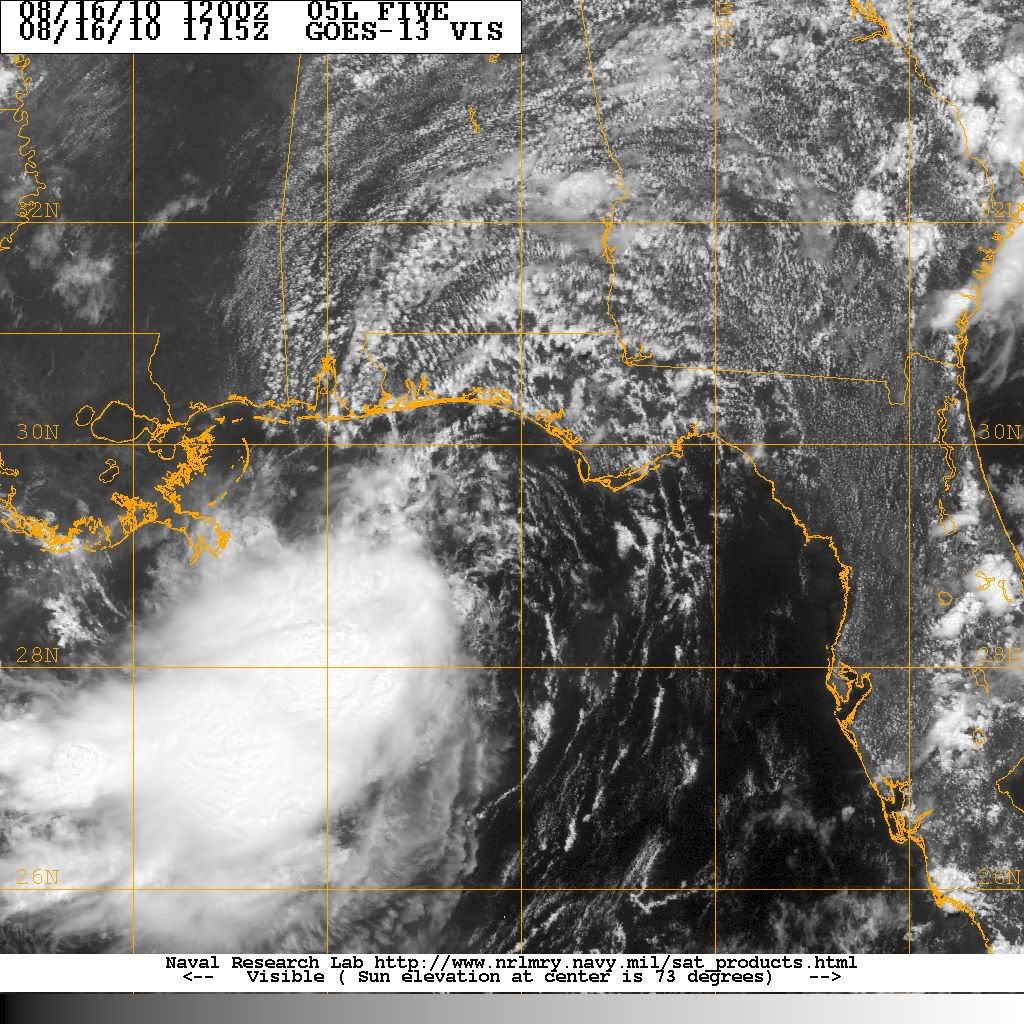
Let's forget the shear for a moment and look at overall
structure of the system which IMO looks great. If and
that's a big if the shear lessens then I think this will become
a TD then a TS before landfall.
http://www.rap.ucar.edu/weather/satelli ... uration=12
structure of the system which IMO looks great. If and
that's a big if the shear lessens then I think this will become
a TD then a TS before landfall.
http://www.rap.ucar.edu/weather/satelli ... uration=12
0 likes
-
Brent
- S2K Supporter
- Posts: 38769
- Age: 37
- Joined: Sun May 16, 2004 10:30 pm
- Location: Tulsa Oklahoma
- Contact:
Re: ATL: EX-Tropical Depression FIVE - Discussion
tolakram wrote:Loop: http://wwwghcc.msfc.nasa.gov/cgi-bin/ge ... umframes=5
Regardless of the shear maps reality shows a highly sheared system with little or no convection to the north and east.
Yep, I'm here in Pensacola Beach and it's a near perfect day other than a couple of 5-minute showers so far. The Gulf is calm too with barely any waves. Never would know a potential TD is not far away.
0 likes
#neversummer

Re: ATL: EX-Tropical Depression FIVE - Discussion
the LLC is moving towards the deep convection...that is where the lower pressure will be..which is west or tad south of west.....you guys are killing me.  ....can you give it another 6 hours and let it stack....if it doesnt you can continue on with your season over proclamations....2010 year of the ULL and shear? We have shear and ULL's every year......could it be that the MJO is unfavorabel right now..
no need to panic....there will be plenty to look at this weekend and probably more than one...
no need to panic....there will be plenty to look at this weekend and probably more than one...
0 likes
Re: ATL: EX-Tropical Depression FIVE - Discussion
Watching the latest hi-res Visible loop the LLC is still elongated but not near as much as it was early this morning. If you go out to the wideview( mid) you can also see the rather large Circ.
http://weather.msfc.nasa.gov/GOES/goeseastconus.html
http://weather.msfc.nasa.gov/GOES/goeseastconus.html
0 likes
The following post is NOT an official forecast and should not be used as such. It is just the opinion of the poster and may or may not be backed by sound meteorological data. It is NOT endorsed by any professional institution including storm2k.org For Official Information please refer to the NHC and NWS products.
Who is online
Users browsing this forum: No registered users and 94 guests