ATL: GASTON - Models

Moderator: S2k Moderators

Message
Author
User avatar
cycloneye
Admin
Admin
Posts: 139756
Age: 67
Joined: Thu Oct 10, 2002 10:54 am
Location: San Juan, Puerto Rico

Re: ATL: Invest 98L - Models

#21 Postby cycloneye » Tue Aug 31, 2010 1:46 pm

18z Tropical Models

Code: Select all

 
WHXX01 KWBC 311844
CHGHUR
TROPICAL CYCLONE GUIDANCE MESSAGE
NWS TPC/NATIONAL HURRICANE CENTER MIAMI FL
1844 UTC TUE AUG 31 2010
 
DISCLAIMER...NUMERICAL MODELS ARE SUBJECT TO LARGE ERRORS.
PLEASE REFER TO NHC OFFICIAL FORECASTS FOR TROPICAL CYCLONE
AND SUBTROPICAL CYCLONE INFORMATION.
 
ATLANTIC OBJECTIVE AIDS FOR
 
DISTURBANCE INVEST (AL982010) 20100831 1800 UTC
 
        ...00 HRS...   ...12 HRS...   ...24 HRS. ..   ...36 HRS...
        100831  1800   100901  0600   100901  1800   100902  0600
 
         LAT    LON     LAT    LON     LAT    LON     LAT    LON
BAMS    12.0N  31.0W   12.3N  33.6W   12.8N  36.1W   12.9N  38.3W
BAMD    12.0N  31.0W   12.6N  33.3W   13.3N  35.4W   14.0N  37.1W
BAMM    12.0N  31.0W   12.5N  33.5W   13.0N  35.8W   13.4N  37.7W
LBAR    12.0N  31.0W   12.7N  33.7W   13.6N  36.6W   14.1N  39.3W
SHIP        25KTS          27KTS          31KTS          36KTS
DSHP        25KTS          27KTS          31KTS          36KTS
 
        ...48 HRS...   ...72 HRS...   ...96 HRS. ..   ..120 HRS...
        100902  1800   100903  1800   100904  1800   100905  1800
 
         LAT    LON     LAT    LON     LAT    LON     LAT    LON
BAMS    13.1N  40.4W   13.6N  44.5W   14.7N  48.8W   16.1N  53.8W
BAMD    14.8N  38.3W   16.8N  41.3W   19.5N  44.5W   21.1N  47.3W
BAMM    13.8N  39.2W   14.8N  42.6W   16.4N  46.5W   18.1N  50.8W
LBAR    14.6N  41.7W   16.6N  45.6W   21.1N  48.4W   25.1N  48.7W
SHIP        39KTS          44KTS          45KTS          48KTS
DSHP        39KTS          44KTS          45KTS          48KTS
 
         ...INITIAL CONDITIONS...
LATCUR =  12.0N LONCUR =  31.0W DIRCUR = 295DEG SPDCUR =  16KT
LATM12 =  10.3N LONM12 =  28.0W DIRM12 = 289DEG SPDM12 =  16KT
LATM24 =   9.9N LONM24 =  25.1W
WNDCUR =   25KT RMAXWD =   45NM WNDM12 =   25KT
CENPRS = 1008MB OUTPRS = 1009MB OUTRAD =  180NM SDEPTH =   S
RD34NE =    0NM RD34SE =    0NM RD34SW =    0NM RD34NW =   0NM
 
$$
NNNN


Image
0 likes   
Visit the Caribbean-Central America Weather Thread where you can find at first post web cams,radars
and observations from Caribbean basin members Click Here

tolakram
Admin
Admin
Posts: 19184
Age: 61
Joined: Sun Aug 27, 2006 8:23 pm
Location: Florence, KY (name is Mark)

Re: ATL: Invest 98L - Models

#22 Postby tolakram » Tue Aug 31, 2010 2:09 pm

12Z Euro, 72 hours

Image
0 likes   
M a r k
- - - - -
Join us in chat: Storm2K Chatroom Invite. Android and IOS apps also available.

The posts in this forum are NOT official forecasts and should not be used as such. Posts are NOT endorsed by any professional institution or STORM2K.org. For official information and forecasts, please refer to NHC and NWS products.

User avatar
ConvergenceZone
Category 5
Category 5
Posts: 4833
Joined: Fri Jul 29, 2005 1:40 am
Location: Northern California

#23 Postby ConvergenceZone » Tue Aug 31, 2010 2:17 pm

Hmmm, what do you all think. Does this have more landfall potential than the others?
0 likes   

HURRICANELONNY
Category 5
Category 5
Posts: 1381
Joined: Wed May 07, 2003 6:48 am
Location: HOLLYWOOD.FL

Re: ATL: Invest 98L - Models

#24 Postby HURRICANELONNY » Tue Aug 31, 2010 3:08 pm

Where is it? All I see is Earl.
0 likes   
hurricanelonny

StormClouds63
Category 2
Category 2
Posts: 583
Age: 61
Joined: Tue May 13, 2008 11:56 am
Location: Southwest Louisiana

Re: ATL: Invest 98L - Models

#25 Postby StormClouds63 » Tue Aug 31, 2010 4:19 pm

HURRICANELONNY wrote:Where is it? All I see is Earl.


I don't see anything either, other than "Big Earl." The ridge appears to be building westward, but no closed low.
0 likes   

User avatar
ROCK
Category 5
Category 5
Posts: 9254
Age: 53
Joined: Tue Aug 17, 2004 7:30 am
Location: Kemah, Texas

Re: ATL: Invest 98L - Models

#26 Postby ROCK » Tue Aug 31, 2010 5:06 pm

the ECM doesnt see on that last run...ECM is never good at predicting development but it really good at track IMO.....the CMC sees it so that is good enough for me...
0 likes   

User avatar
CalmBeforeStorm
Category 2
Category 2
Posts: 600
Age: 70
Joined: Tue Aug 10, 2004 7:55 pm
Location: Stuart, Florida

Re: ATL: Invest 98L - Models

#27 Postby CalmBeforeStorm » Tue Aug 31, 2010 5:12 pm

ROCK wrote:the ECM doesnt see on that last run...ECM is never good at predicting development but it really good at track IMO.....the CMC sees it so that is good enough for me...

The ECM wasn't good with Fiona whether it recurves or not as the model has flip-flopped solutions while the GFS has been consistant with the recurve and probable disapation of Fiona by Earl. Bottom line is some of the reliable models do better with some storms. That's why the NHC takes a blend.
0 likes   

jlauderdal
S2K Supporter
S2K Supporter
Posts: 6818
Joined: Wed May 19, 2004 5:46 am
Location: NE Fort Lauderdale
Contact:

Re: ATL: Invest 98L - Models

#28 Postby jlauderdal » Tue Aug 31, 2010 5:23 pm

ROCK wrote:the ECM doesnt see on that last run...ECM is never good at predicting development but it really good at track IMO.....the CMC sees it so that is good enough for me...


really, the euro is never good at predicting development, go back and check to see how it did with ALEX
0 likes   

CYCLONE MIKE
Category 5
Category 5
Posts: 2183
Joined: Tue Aug 31, 2004 6:04 pm
Location: Gonzales, LA

Re: ATL: Invest 98L - Models

#29 Postby CYCLONE MIKE » Tue Aug 31, 2010 5:57 pm

Lets not start the model wars again guys. The models have their good days and bad. I thought the euro was really on to something with Fiona, getting in the gulf, which I had been worried about since it was an invest. While the GFS was calling for much of nothing and curving out to sea or getting eaten alive by Earl. So the GFS got it right this time around maybe the Euro will be right with 98L?
0 likes   

User avatar
CalmBeforeStorm
Category 2
Category 2
Posts: 600
Age: 70
Joined: Tue Aug 10, 2004 7:55 pm
Location: Stuart, Florida

Re: ATL: Invest 98L - Models

#30 Postby CalmBeforeStorm » Tue Aug 31, 2010 6:00 pm

CYCLONE MIKE wrote:Lets not start the model wars again guys. The models have their good days and bad. I thought the euro was really on to something with Fiona, getting in the gulf, which I had been worried about since it was an invest. While the GFS was calling for much of nothing and curving out to sea or getting eaten alive by Earl. So the GFS got it right this time around maybe the Euro will be right with 98L?

Which is why it's wise not to fall in love with a particular model but to instead take a blend, particularly at the long range where no models have a good track record.
0 likes   

User avatar
Ivanhater
Storm2k Moderator
Storm2k Moderator
Posts: 10859
Age: 37
Joined: Fri Jul 01, 2005 8:25 am
Location: Pensacola

Re: ATL: Invest 98L - Models

#31 Postby Ivanhater » Tue Aug 31, 2010 6:14 pm

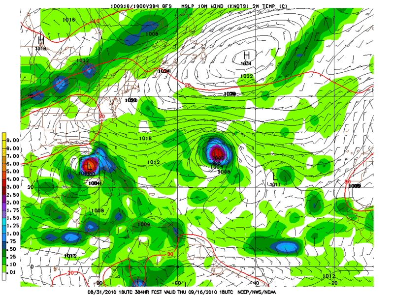
That is 98L in the long range GFS by the Florida Keys

Image
0 likes   
Michael

Sihara
Tropical Storm
Tropical Storm
Posts: 137
Joined: Wed Jul 16, 2008 8:39 pm
Location: St. Petersburg, FL

Re: ATL: Invest 98L - Models

#32 Postby Sihara » Tue Aug 31, 2010 6:20 pm

That's not a very nice picture, Michael. How much stock can be put in it - cause I would seriously not like to see that happening. :eek:
0 likes   

User avatar
thetruesms
Professional-Met
Professional-Met
Posts: 844
Age: 40
Joined: Thu Aug 16, 2007 1:14 pm
Location: Tallahasee, FL
Contact:

Re: ATL: Invest 98L - Models

#33 Postby thetruesms » Tue Aug 31, 2010 6:25 pm

Sihara wrote:That's not a very nice picture, Michael. How much stock can be put in it - cause I would seriously not like to see that happening. :eek:
Well, it's certainly possible, but I wouldn't be laying down anything of value on it happening. Maybe, if I felt exceptionally convinced it would happen (I don't), I'd wager a lunch on it and then set aside some money to pay for lunch in a couple weeks :lol:
0 likes   

User avatar
KWT
Category 5
Category 5
Posts: 31391
Joined: Tue Aug 17, 2004 11:02 am
Location: UK!!!

#34 Postby KWT » Tue Aug 31, 2010 6:26 pm

Yeah that is 98L but its barely even a wave for the first 6-7 days, its VERY hard to track it through the Vort but I'm going to assume from the wind shifts at 850hpa throughout that it would be 98L the GFS shows in that position.

Of course we've been saying all along, if we get a weak system that makes it past 55-60W...then we have a huge threat on our hands.
0 likes   
Personal Forecast Disclaimer:
The posts in this forum are NOT official forecast and should not be used as such. They are just the opinion of the poster and may or may not be backed by sound meteorological data. They are NOT endorsed by any professional institution or storm2k.org. For official information, please refer to the NHC and NWS products

User avatar
ColinDelia
S2K Supporter
S2K Supporter
Posts: 918
Joined: Mon Aug 29, 2005 5:52 am
Location: The Beach, FL

#35 Postby ColinDelia » Tue Aug 31, 2010 6:26 pm

I haven't seen the run past 168 hours yet but if you follow the vorticity from 98L to 168 hours the GFS just spins it in the same place.

http://moe.met.fsu.edu/cgi-bin/gfstc2.c ... =Animation

So the GFS keeps 98L in place for 168 hours and then moves it west to Key West? Doesn't really make sense since 98L is moving west at 15 mph right now.

Or am I missing something?
0 likes   

User avatar
ColinDelia
S2K Supporter
S2K Supporter
Posts: 918
Joined: Mon Aug 29, 2005 5:52 am
Location: The Beach, FL

#36 Postby ColinDelia » Tue Aug 31, 2010 6:28 pm

KWT (or anyone) where do you see 98L at 168 hours in the 18z GFS? To me looks like 32 W.
0 likes   

User avatar
ColinDelia
S2K Supporter
S2K Supporter
Posts: 918
Joined: Mon Aug 29, 2005 5:52 am
Location: The Beach, FL

Re: ATL: Invest 98L - Models

#37 Postby ColinDelia » Tue Aug 31, 2010 6:30 pm

174 hours. Is "98L" at 32 W here?

Image
0 likes   

User avatar
cycloneye
Admin
Admin
Posts: 139756
Age: 67
Joined: Thu Oct 10, 2002 10:54 am
Location: San Juan, Puerto Rico

Re: ATL: Invest 98L - Models

#38 Postby cycloneye » Tue Aug 31, 2010 6:32 pm

My question is if this on the long range in the NW Caribbean/South of Florida is 98L?

http://www.nco.ncep.noaa.gov/pmb/nwprod ... loop.shtml

Edit= I didn't see Ivans post. :)
0 likes   
Visit the Caribbean-Central America Weather Thread where you can find at first post web cams,radars
and observations from Caribbean basin members Click Here

User avatar
Ivanhater
Storm2k Moderator
Storm2k Moderator
Posts: 10859
Age: 37
Joined: Fri Jul 01, 2005 8:25 am
Location: Pensacola

Re: ATL: Invest 98L - Models

#39 Postby Ivanhater » Tue Aug 31, 2010 6:33 pm

Colin, I believe it is that weak reflection about to enter the extreme Southern Caribbean

At 228 hours, it starts to take shape in the Caribbean. I believe that fits with the current movement and speed of 98L

Image
0 likes   
Michael

User avatar
KWT
Category 5
Category 5
Posts: 31391
Joined: Tue Aug 17, 2004 11:02 am
Location: UK!!!

#40 Postby KWT » Tue Aug 31, 2010 6:37 pm

Yeah Ivanhater is right, but its real weak and I can't be totally sure if its 98L or just another disturbance from the ITCZ it picks up, but from the looks of things it rides near due west and stays real weak...you can only tell its there by the wind shift that occurs on the 850hpa vort map from NCEP.
0 likes   
Personal Forecast Disclaimer:
The posts in this forum are NOT official forecast and should not be used as such. They are just the opinion of the poster and may or may not be backed by sound meteorological data. They are NOT endorsed by any professional institution or storm2k.org. For official information, please refer to the NHC and NWS products


Return to “2010”

Who is online

Users browsing this forum: No registered users and 9 guests