

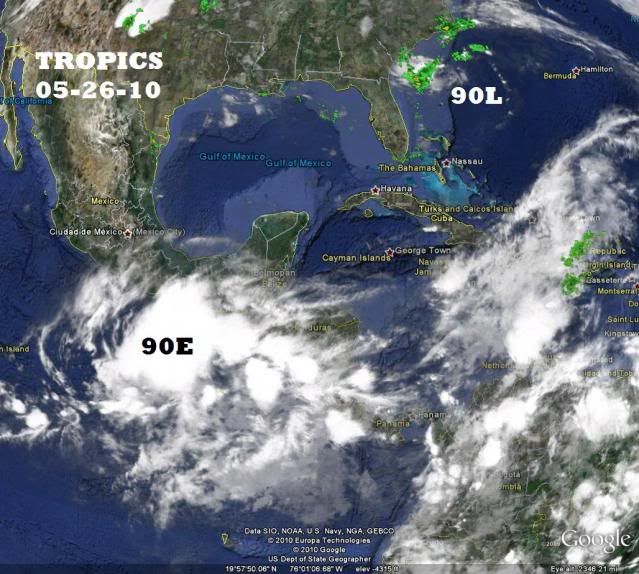
18Z GFDL run of 90L has this disturbance crossing over, becoming a tropical storm south of Cuba, and headed for south FL.
http://moe.met.fsu.edu/cgi-bin/gfdltc2.cgi?time=2010052518-invest90l&field=Sea+Level+Pressure&hour=Animation
EPAC : EX TROPICAL DEPRESSION AGATHA
Moderator: S2k Moderators
Re: EPAC : INVEST 90E
0 likes
-
cycloneye

- Admin

- Posts: 149682
- Age: 69
- Joined: Thu Oct 10, 2002 10:54 am
- Location: San Juan, Puerto Rico
Re: EPAC : INVEST 90E
00 UTC Best Track
ftp://ftp.tpc.ncep.noaa.gov/atcf/tcweb/ ... 010.invest
EP, 90, 2010052600, , BEST, 0, 112N, 891W, 20, 1007, DB
ftp://ftp.tpc.ncep.noaa.gov/atcf/tcweb/ ... 010.invest
EP, 90, 2010052600, , BEST, 0, 112N, 891W, 20, 1007, DB
0 likes
Visit the Caribbean-Central America Weather Thread where you can find at first post web cams,radars
and observations from Caribbean basin members Click Here
and observations from Caribbean basin members Click Here
-
cycloneye
- Admin
- Posts: 149682
- Age: 69
- Joined: Thu Oct 10, 2002 10:54 am
- Location: San Juan, Puerto Rico
Re: EPAC : INVEST 90E
At the 00 UTC run SHIP makes it a hurricane at 69kts.
WHXX01 KMIA 260057
CHGE77
TROPICAL CYCLONE GUIDANCE MESSAGE
NWS TPC/NATIONAL HURRICANE CENTER MIAMI FL
0057 UTC WED MAY 26 2010
DISCLAIMER...NUMERICAL MODELS ARE SUBJECT TO LARGE ERRORS.
PLEASE REFER TO NHC OFFICIAL FORECASTS FOR TROPICAL CYCLONE
AND SUBTROPICAL CYCLONE INFORMATION.
EAST PACIFIC OBJECTIVE AIDS FOR
DISTURBANCE INVEST (EP902010) 20100526 0000 UTC
...00 HRS... ...12 HRS... ...24 HRS. .. ...36 HRS...
100526 0000 100526 1200 100527 0000 100527 1200
LAT LON LAT LON LAT LON LAT LON
BAMS 11.2N 89.1W 12.0N 89.5W 13.2N 90.4W 13.9N 91.3W
BAMD 11.2N 89.1W 11.3N 90.0W 11.9N 91.1W 12.7N 92.4W
BAMM 11.2N 89.1W 11.6N 90.0W 12.2N 91.0W 12.8N 92.3W
LBAR 11.2N 89.1W 11.6N 89.6W 12.8N 90.3W 13.9N 91.0W
SHIP 20KTS 26KTS 36KTS 45KTS
DSHP 20KTS 26KTS 36KTS 45KTS
...48 HRS... ...72 HRS... ...96 HRS. .. ..120 HRS...
100528 0000 100529 0000 100530 0000 100531 0000
LAT LON LAT LON LAT LON LAT LON
BAMS 14.4N 92.3W 15.2N 93.2W 15.9N 91.1W 17.8N 88.4W
BAMD 13.5N 93.7W 14.5N 95.6W 15.0N 96.4W 16.1N 96.8W
BAMM 13.4N 93.4W 14.4N 94.6W 15.7N 93.4W 17.2N 92.5W
LBAR 15.0N 91.1W 17.2N 88.4W 18.6N 81.5W 24.6N 70.3W
SHIP 55KTS 69KTS 59KTS 52KTS
DSHP 55KTS 69KTS 52KTS 30KTS
...INITIAL CONDITIONS...
LATCUR = 11.2N LONCUR = 89.1W DIRCUR = 290DEG SPDCUR = 3KT
LATM12 = 11.0N LONM12 = 88.6W DIRM12 = 289DEG SPDM12 = 3KT
LATM24 = 10.8N LONM24 = 88.0W
WNDCUR = 20KT RMAXWD = 20NM WNDM12 = 20KT
CENPRS = 1007MB OUTPRS = 1008MB OUTRAD = 160NM SDEPTH = D
RD34NE = 0NM RD34SE = 0NM RD34SW = 0NM RD34NW = 0NM
0 likes
Visit the Caribbean-Central America Weather Thread where you can find at first post web cams,radars
and observations from Caribbean basin members Click Here
and observations from Caribbean basin members Click Here

Re: EPAC : INVEST 90E
Green alert has been declared in El Salvador, the SNET (salvadorian meteorological service) has said that a "Temporal" will develop beggining tonight and will last through friday, in El Salvador a "temporal" is an event that produce completely cloudy skies and almost permanent showers in a period of 24 hours or more with rainfall amounts of 100 mm/4 inches or more per day.
Take a look at this map, this is the accumulated rainfall in mm between 7:00 am yesterday and 7:00 am today

In San Vicente 119 mm/4.69 inches fell in ju8st 24 hours, is important to mention that San Vicente was the most affected department (province) on november 2009 when a low pressure system left 200 dead in El Salvador.
Take a look at this map, this is the accumulated rainfall in mm between 7:00 am yesterday and 7:00 am today
In San Vicente 119 mm/4.69 inches fell in ju8st 24 hours, is important to mention that San Vicente was the most affected department (province) on november 2009 when a low pressure system left 200 dead in El Salvador.
0 likes
-
cycloneye
- Admin
- Posts: 149682
- Age: 69
- Joined: Thu Oct 10, 2002 10:54 am
- Location: San Juan, Puerto Rico
Re: EPAC : INVEST 90E
00z NAM has the crossover from EPAC to Caribbean.Let's see what the rest of the model guidance has at the 00z run.
00z NAM loop
00z NAM loop
0 likes
Visit the Caribbean-Central America Weather Thread where you can find at first post web cams,radars
and observations from Caribbean basin members Click Here
and observations from Caribbean basin members Click Here
-
carolina_73

- Tropical Storm

- Posts: 148
- Joined: Wed Jul 23, 2008 1:30 am
Re: EPAC : INVEST 90E
90E sure is popping right now. http://www.ssd.noaa.gov/goes/east/epac/avn-l.jpg
0 likes

Yep big convective blow up right now and a solid looking ball of convection, I'd expect a tropical depression today given its look at the moment...
Looks like it may be forming a little further west as well then the models are expecting which may have an effect on the risk of any cross-over, though the energy may well end up in the Caribbean still, it could possibly end up in the Gulf instead...too early to tell though of course!
Looks like it may be forming a little further west as well then the models are expecting which may have an effect on the risk of any cross-over, though the energy may well end up in the Caribbean still, it could possibly end up in the Gulf instead...too early to tell though of course!
0 likes
Personal Forecast Disclaimer:
The posts in this forum are NOT official forecast and should not be used as such. They are just the opinion of the poster and may or may not be backed by sound meteorological data. They are NOT endorsed by any professional institution or storm2k.org. For official information, please refer to the NHC and NWS products
The posts in this forum are NOT official forecast and should not be used as such. They are just the opinion of the poster and may or may not be backed by sound meteorological data. They are NOT endorsed by any professional institution or storm2k.org. For official information, please refer to the NHC and NWS products

-
Ad Novoxium
- Category 1

- Posts: 348
- Age: 35
- Joined: Sat May 03, 2008 2:12 am
Re: EPAC : INVEST 90E
I think it also has to do with forward speed of the storm. Since Atlantic storms go straight ahead (through Central America), most storm speed over land and make it through intact (Cesar, Joan, Fifi). Although Stan nearly did in 05, it just was not fast enough, and neither was Dean. Finally, Mitch got torn all to shreds on the mountains from slow movement in the same area Fifi hit.
As for the Pacific, the storms move slower due to steering, so that if any DO cross, it's in pieces (there are, at best, maybe four instances of storms actually doing this intact, even though I only recall two: One in 44 I think and Cosme in 89 to a degree).
Be warned that I'm not a certified forecaster, so I may be wrong here.
0 likes
Re:
Chacor wrote:I think it's a bit premature to be hyping a solid crossover. Remnants of the system might make it, but Central America is very mountainous and not conducive to storms holding together in a crossover.
Yeah your right but thats why I said the energy left over from whatever forms could end up making it into the Caribberan. much depends on how deep and sharp the upper trough digs down the east coast of the US.
I personally think if there is a risk, its actually going to be in the BoC rather than the Caribbean.
0 likes
Personal Forecast Disclaimer:
The posts in this forum are NOT official forecast and should not be used as such. They are just the opinion of the poster and may or may not be backed by sound meteorological data. They are NOT endorsed by any professional institution or storm2k.org. For official information, please refer to the NHC and NWS products
The posts in this forum are NOT official forecast and should not be used as such. They are just the opinion of the poster and may or may not be backed by sound meteorological data. They are NOT endorsed by any professional institution or storm2k.org. For official information, please refer to the NHC and NWS products
-
Hurricane Andrew

- S2K Supporter

- Posts: 1891
- Age: 27
- Joined: Sun May 23, 2010 2:53 pm
- Location: KS
Re: EPAC : INVEST 90E
Right on the verge of Code Red...
TROPICAL WEATHER OUTLOOK
NWS TPC/NATIONAL HURRICANE CENTER MIAMI FL
500 AM PDT WED MAY 26 2010
FOR THE EASTERN NORTH PACIFIC...EAST OF 140 DEGREES WEST LONGITUDE..
A LARGE AREA OF DISTURBED WEATHER CONTINUES SOUTH OF CENTRAL AMERICA
AND EASTERN MEXICO. SATELLITE IMAGES THIS MORNING INDICATE THAT THE
ACTIVITY HAS BECOME MORE CONCENTRATED ABOUT 175 MILES SOUTH OF THE
GULF OF TEHUANTEPEC. ENVIRONMENTAL CONDITIONS APPEAR TO BE
FAVORABLE FOR ADDITIONAL DEVELOPMENT...AND A TROPICAL DEPRESSION
COULD FORM DURING THE NEXT DAY OR TWO AS THE SYSTEM DRIFTS TOWARD
THE NORTHWEST. REGARDLESS OF DEVELOPMENT...THIS SYSTEM HAS THE
POTENTIAL TO PRODUCE LOCALLY HEAVY RAINS AND FLOODING OVER PORTIONS
OF CENTRAL AMERICA DURING THE NEXT FEW DAYS. THERE IS A MEDIUM
CHANCE...50 PERCENT...OF THIS SYSTEM BECOMING A TROPICAL CYCLONE
DURING THE NEXT 48 HOURS.
ELSEWHERE...TROPICAL CYCLONE FORMATION IS NOT EXPECTED DURING THE
NEXT 48 HOURS.
0 likes
-
Kingarabian

- S2K Supporter
- Posts: 16377
- Joined: Sat Aug 08, 2009 3:06 am
- Location: Honolulu, Hawaii
Re: EPAC : INVEST 90E
Code Orange again. I think if it develops into a storm then it has a legit chance of regenerating in the gulf. But if it stays like this then it probably will get torn apart.
-High school Senior's point of view!
-High school Senior's point of view!
0 likes
RIP Kobe Bryant


-
Hurricane Andrew
- S2K Supporter
- Posts: 1891
- Age: 27
- Joined: Sun May 23, 2010 2:53 pm
- Location: KS
-
cycloneye
- Admin
- Posts: 149682
- Age: 69
- Joined: Thu Oct 10, 2002 10:54 am
- Location: San Juan, Puerto Rico
Re: EPAC : INVEST 90E
12z Best Track
EP, 90, 2010052612, , BEST, 0, 142N, 951W, 25, 1006, DB
EP, 90, 2010052612, , BEST, 0, 142N, 951W, 25, 1006, DB
0 likes
Visit the Caribbean-Central America Weather Thread where you can find at first post web cams,radars
and observations from Caribbean basin members Click Here
and observations from Caribbean basin members Click Here
-
Evil Jeremy

- S2K Supporter
- Posts: 5463
- Age: 32
- Joined: Mon Apr 10, 2006 2:10 pm
- Location: Los Angeles, CA
Re: EPAC : INVEST 90E
No doubt now that this will be a classified system soon (well, there is always doubt in the tropics). What will be interesting is what part of Central America it uses to make its journey to the Caribbean. If it moves over one the skinnier areas, and forms a strong and organized circulation (which it's well on it's way to doing), this could hold over in the Caribbean, or at least send a chunk of tropical energy which can spawn a new system. I don't know about the rest of the 06z models, but I just looked at the GFS, and it doesn't seem to keen on anything organized in the Caribbean though.
0 likes
Frances 04 / Jeanne 04 / Katrina 05 / Wilma 05 / Fay 08 / Debby 12 / Andrea 13 / Colin 16 / Hermine 16 / Matthew 16 / Irma 17

-
cycloneye
- Admin
- Posts: 149682
- Age: 69
- Joined: Thu Oct 10, 2002 10:54 am
- Location: San Juan, Puerto Rico
Re:
HURAKAN wrote:26/1145 UTC 10.4N 95.6W TOO WEAK 90E -- East Pacific
Why is this looking at 10.4ºN??? lol
It must be a typing error as best track position is at 14.2N.
0 likes
Visit the Caribbean-Central America Weather Thread where you can find at first post web cams,radars
and observations from Caribbean basin members Click Here
and observations from Caribbean basin members Click Here
Who is online
Users browsing this forum: No registered users and 94 guests