ATL: IGOR - Ex Hurricane - Discussion
Moderator: S2k Moderators
Re: ATL: IGOR - Hurricane - Discussion
Thank you, wxman, for your explanation of the recurves. I appreciate your taking the time to help me understand.
0 likes
-
weatherguy2
- Tropical Depression

- Posts: 72
- Joined: Sun Aug 01, 2010 2:45 am
Re: ATL: IGOR - Hurricane - Discussion
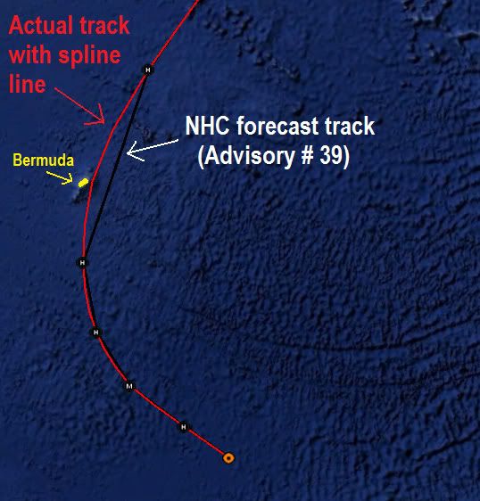
abajan wrote:That’s actually incorrect because storms don’t move in straight lines from point to point as illustrated on the chart. If the track line were smoothed out, the eye would indeed go directly over Bermuda. That’s why I think the line should not be included on the charts. But you are certainly correct in stating that Igor (more precisely, its center) could do anything (go anywhere) within the error cone.Blown Away wrote:hurricaneCW wrote:I think some people have explained this before but the hurricane is not going to go directly from one point to the other. Igor will most likely approach the point past Bermuda while it's gradually curving from the N to the NNE and NE. This means that Igor could curve right on top of Bermuda and even just to the west of it.
Igor could do anything within the error cone but for now the NHC has Igor passing just east of Bermuda. It only takes a 75-100 mile east shift to keep the core hurricane winds just offshore.
The preceding post is NOT an official forecast and should not be used as such. It is just the opinion of the poster and may or may not be backed by sound meteorological data. It is NOT endorsed by any professional institution including storm2k.org. For Official Information please refer to the NHC and NWS products.
Yep, I agree, 100%, The western Eye wall will pretty much pass right over Bermuda if the NHC Advisory #39 forecast track is right.
Hurricanes in the large scale have smooth track lines not jagged. The NHC lines are not for a real track, they only connect the forecasted points. The best of the early cycle 18z models also follow the spline line on my map below.
here is a map I made to explain to people that are confused:

0 likes
-
Battlebrick
- Tropical Storm

- Posts: 177
- Joined: Thu Sep 02, 2010 9:55 pm
Re: ATL: IGOR - Hurricane - Discussion
I think recon is out, if anyone can update us with the Google Earth pics and stuff, that would be great (I have no clue how haha)
But yeah, I see an eye coming, probably exiting EWRC. Wind field is going to be bigger than big.
But yeah, I see an eye coming, probably exiting EWRC. Wind field is going to be bigger than big.
0 likes
Lim_Fao on IRC.
The following post is NOT an official forecast and should not be used as such. It is just the opinion of the poster and may or may not be backed by sound meteorological data. It is NOT endorsed by any professional institution including storm2k.org. For Official Information please refer to the NHC and NWS products.
The following post is NOT an official forecast and should not be used as such. It is just the opinion of the poster and may or may not be backed by sound meteorological data. It is NOT endorsed by any professional institution including storm2k.org. For Official Information please refer to the NHC and NWS products.
-
weatherguy2
- Tropical Depression

- Posts: 72
- Joined: Sun Aug 01, 2010 2:45 am
-
hurricaneCW
- Category 5

- Posts: 1799
- Joined: Wed Mar 03, 2010 6:20 am
- Location: Toms River, NJ
Re: ATL: IGOR - Hurricane - Discussion
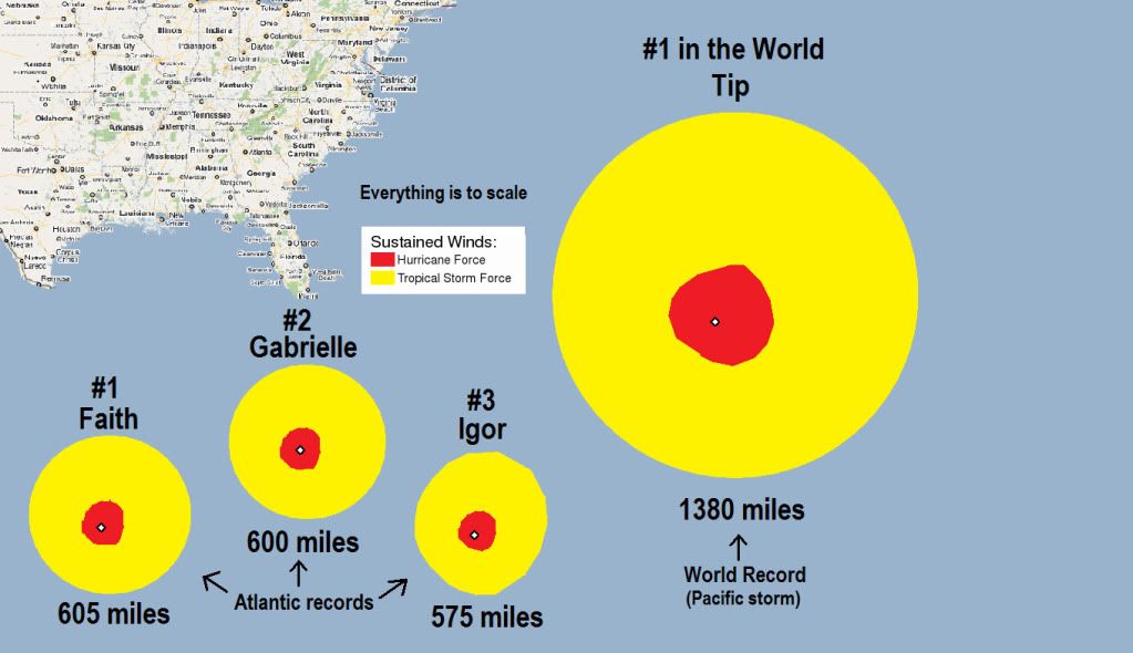
Wow, that's amazing how Tip would fit in the Atlantic. If Igor were as large as Tip and was moving toward the east coast, then we'd have tropical storm force winds from the Florida Keys to the Northern Mid-Atlantic.
0 likes
- cycloneye
- Admin

- Posts: 149721
- Age: 69
- Joined: Thu Oct 10, 2002 10:54 am
- Location: San Juan, Puerto Rico
Re: ATL: IGOR - Hurricane - Discussion
Getting stronger again.
SUMMARY OF 1100 PM AST...0300 UTC...INFORMATION
-----------------------------------------------
LOCATION...24.6N 62.0W
ABOUT 560 MI...900 KM SSE OF BERMUDA
MAXIMUM SUSTAINED WINDS...110 MPH...175 KM/HR
PRESENT MOVEMENT...NW OR 315 DEGREES AT 13 MPH...20 KM/HR
MINIMUM CENTRAL PRESSURE...947 MB...27.96 INCHES
0 likes
Visit the Caribbean-Central America Weather Thread where you can find at first post web cams,radars
and observations from Caribbean basin members Click Here
and observations from Caribbean basin members Click Here
- cycloneye
- Admin

- Posts: 149721
- Age: 69
- Joined: Thu Oct 10, 2002 10:54 am
- Location: San Juan, Puerto Rico
Re: ATL: IGOR - Hurricane - Discussion

0 likes
Visit the Caribbean-Central America Weather Thread where you can find at first post web cams,radars
and observations from Caribbean basin members Click Here
and observations from Caribbean basin members Click Here
Re: ATL: IGOR - Hurricane - Discussion
Igor is such an amazing and very very interesting storm unfortunately Bermuda is on its way.
0 likes
-
Battlebrick
- Tropical Storm

- Posts: 177
- Joined: Thu Sep 02, 2010 9:55 pm
Re: ATL: IGOR - Hurricane - Discussion
Recon just found a pressure of 939 mb.
0 likes
Lim_Fao on IRC.
The following post is NOT an official forecast and should not be used as such. It is just the opinion of the poster and may or may not be backed by sound meteorological data. It is NOT endorsed by any professional institution including storm2k.org. For Official Information please refer to the NHC and NWS products.
The following post is NOT an official forecast and should not be used as such. It is just the opinion of the poster and may or may not be backed by sound meteorological data. It is NOT endorsed by any professional institution including storm2k.org. For Official Information please refer to the NHC and NWS products.
Headlines from the Royal Gazette
http://www.royalgazette.com/rg/Article/ ... ctionId=60
http://www.royalgazette.com/rg/Article/ ... ctionId=60
Thankfully, they're shutting down the Causeway early this time. IIRC, that's where the Fabian deaths occurred.
http://www.royalgazette.com/rg/Article/ ... ctionId=60
http://www.royalgazette.com/rg/Article/ ... ctionId=60
Thankfully, they're shutting down the Causeway early this time. IIRC, that's where the Fabian deaths occurred.
0 likes
Re: ATL: IGOR - Hurricane - Discussion
http://rammb.cira.colostate.edu/ramsdis ... _floater_1
wobble wobble west......
hopefully igor doesn't have any tricks up his sleeve....
wobble wobble west......
hopefully igor doesn't have any tricks up his sleeve....
0 likes
-
HurricaneRobert
- Category 3

- Posts: 812
- Joined: Fri May 18, 2007 9:31 pm
Re: ATL: IGOR - Hurricane - Discussion
Karl took his thunder for a little while, but now look who is still there in the Atlantic.
0 likes
-
weatherguy2
- Tropical Depression

- Posts: 72
- Joined: Sun Aug 01, 2010 2:45 am
Re: ATL: IGOR - Hurricane - Discussion
Recon: Extrap. Sfc. Press: 936.2 mb
Dropsonde: 939mb (actual pressure)
Dropsonde: 939mb (actual pressure)
0 likes
- cycloneye
- Admin

- Posts: 149721
- Age: 69
- Joined: Thu Oct 10, 2002 10:54 am
- Location: San Juan, Puerto Rico
Re: ATL: IGOR - Hurricane - Discussion
SUMMARY OF 800 AM AST...1200 UTC...INFORMATION
----------------------------------------------
LOCATION...25.6N 63.2W
ABOUT 475 MI...765 KM S OF BERMUDA
MAXIMUM SUSTAINED WINDS...110 MPH...175 KM/HR
PRESENT MOVEMENT...NW OR 310 DEGREES AT 13 MPH...20 KM/HR
MINIMUM CENTRAL PRESSURE...939 MB...27.73 INCHES
----------------------------------------------
LOCATION...25.6N 63.2W
ABOUT 475 MI...765 KM S OF BERMUDA
MAXIMUM SUSTAINED WINDS...110 MPH...175 KM/HR
PRESENT MOVEMENT...NW OR 310 DEGREES AT 13 MPH...20 KM/HR
MINIMUM CENTRAL PRESSURE...939 MB...27.73 INCHES
0 likes
Visit the Caribbean-Central America Weather Thread where you can find at first post web cams,radars
and observations from Caribbean basin members Click Here
and observations from Caribbean basin members Click Here
-
bob rulz
- Category 5

- Posts: 1711
- Age: 36
- Joined: Sat Jan 28, 2006 7:30 pm
- Location: Salt Lake City, Utah
Re:
Igor doesn't seem to want to strengthen. The size seems to be interfering with his ability to consolidate - lets hope it stays that way for the sake of Bermuda!
Seems that Igor needs a bit more than the fishes for breakfast this morning!
HURAKAN wrote:poor Julia!
Seems that Igor needs a bit more than the fishes for breakfast this morning!
0 likes
Who is online
Users browsing this forum: No registered users and 33 guests


