
Atlantic Tropical Weather Outlook
--------------------------------------------------------------------------------
000
ABNT20 KNHC 131153
TWOAT
TROPICAL WEATHER OUTLOOK
NWS TPC/NATIONAL HURRICANE CENTER MIAMI FL
800 AM EDT SUN JUN 13 2010
FOR THE NORTH ATLANTIC...CARIBBEAN SEA AND THE GULF OF MEXICO...
A BROAD AREA OF LOW PRESSURE LOCATED ABOUT 800 MILES SOUTHWEST OF
THE SOUTHERNMOST CAPE VERDE ISLANDS HAS CHANGED LITTLE IN
ORGANIZATION. HOWEVER...ENVIRONMENTAL CONDITIONS APPEAR CONDUCIVE
FOR SOME SLOW DEVELOPMENT OF THIS SYSTEM OVER THE NEXT COUPLE OF
DAYS AS IT MOVES WEST-NORTHWESTWARD AT 10 TO 15 MPH. THERE IS A
MEDIUM CHANCE...30 PERCENT...OF THIS SYSTEM BECOMING A TROPICAL
CYCLONE DURING THE NEXT 48 HOURS.
ELSEWHERE...TROPICAL CYCLONE FORMATION IS NOT EXPECTED DURING THE
NEXT 48 HOURS.
$$
FORECASTER KIMBERLAIN
ATL : INVEST 92L - DISCUSSION
Moderator: S2k Moderators
Re: ATL : INVEST 92L
0 likes

-
Meso

- Category 5

- Posts: 1609
- Age: 39
- Joined: Mon Aug 09, 2004 12:14 pm
- Location: South Africa
- Contact:
Re: ATL : INVEST 92L
Nope, just means what it says. The system has neither gotten worse or improved significantly. Any change isn't note-worthy. So basically the same as it was.
0 likes
-
Hurricane Andrew

- S2K Supporter

- Posts: 1891
- Age: 27
- Joined: Sun May 23, 2010 2:53 pm
- Location: KS
Re: ATL : INVEST 92L
Meso wrote:Nope, just means what it says. The system has neither gotten worse or improved significantly. Any change isn't note-worthy. So basically the same as it was.
I think when the tops cool toninght we will have TD1
0 likes
The Enthusiast
NREMT-AEMT, WX nerd
Irene '11, Sandy '12, Irma '17 (SAR)
"Hard to think we were born to live this way..." -Wage War
-
cycloneye

- Admin

- Posts: 149733
- Age: 69
- Joined: Thu Oct 10, 2002 10:54 am
- Location: San Juan, Puerto Rico
Re: ATL : INVEST 92L
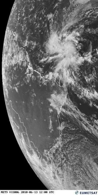
The SSD floater is up for 92L,But the problem is that the focus of the image is way north.I assume,they have noticed the error and will fix the orientation.

0 likes
Visit the Caribbean-Central America Weather Thread where you can find at first post web cams,radars
and observations from Caribbean basin members Click Here
and observations from Caribbean basin members Click Here
-
Hurricane Andrew
- S2K Supporter
- Posts: 1891
- Age: 27
- Joined: Sun May 23, 2010 2:53 pm
- Location: KS
Re: ATL : INVEST 92L
cycloneye wrote:The SSD floater is up for 92L,But the problem is that the focus of the image is way north.I assume,they have noticed the error and will fix the orientation.
I noticed that but is it just me, or do you see a impressive band coming from the storm?
0 likes
The Enthusiast
NREMT-AEMT, WX nerd
Irene '11, Sandy '12, Irma '17 (SAR)
"Hard to think we were born to live this way..." -Wage War
-
cycloneye
- Admin
- Posts: 149733
- Age: 69
- Joined: Thu Oct 10, 2002 10:54 am
- Location: San Juan, Puerto Rico
Re: ATL : INVEST 92L
Visible image loop shows banding growing to the NE of the center which implies is organizing more.
http://rammb.cira.colostate.edu/ramsdis ... km_visible
http://rammb.cira.colostate.edu/ramsdis ... km_visible
0 likes
Visit the Caribbean-Central America Weather Thread where you can find at first post web cams,radars
and observations from Caribbean basin members Click Here
and observations from Caribbean basin members Click Here
-
Hurricane Andrew
- S2K Supporter
- Posts: 1891
- Age: 27
- Joined: Sun May 23, 2010 2:53 pm
- Location: KS
-
wxman57

- Moderator-Pro Met

- Posts: 23175
- Age: 68
- Joined: Sat Jun 21, 2003 8:06 pm
- Location: Houston, TX (southwest)
Re: ATL : INVEST 92L
I do see a NW wind at 15 kts being reported about 200 miles WSW of the disturbance's center. That's indicative of at least a broad LLC having formed. Convection is more concentrated today, another sign of increasing organization. Models still have moderate WSW-W wind shear across the NE Caribbean in its path, though the ECMWF is forecasting a little less shear than yesterday - closer to what the GFS was forecasting. Might have a fair shot at developing over the next 48 hours. Chances increase since I have to fly to San Antonio tomorrow morning to make a presentation to a group of executives for a major oil company and I'll be out-of-pocket as far as being able to assist the hurricane team.
As far as that climatology map which was posted, you really need to just look back to the 1970s when satellite imagery was used to find systems so far out to sea. Prior to satellite, I'm sure there were a number of years with systems developing farther east in June. But, unfortunately, it looks like this is a bad sign of things to come this year.
As far as that climatology map which was posted, you really need to just look back to the 1970s when satellite imagery was used to find systems so far out to sea. Prior to satellite, I'm sure there were a number of years with systems developing farther east in June. But, unfortunately, it looks like this is a bad sign of things to come this year.
0 likes

Re: ATL : INVEST 92L
cycloneye wrote:Visible image loop shows banding growing to the NE of the center which implies is organizing more.
http://rammb.cira.colostate.edu/ramsdis ... km_visible
Thats got a good circulation there...the only slight issue I see is some of that stable air lurking to the north of the system, but as lnog as ther system keeps plowing W/WNW its not going to have to deal with that till a little bit down the line...
I think this one may well be one to go...
0 likes
Personal Forecast Disclaimer:
The posts in this forum are NOT official forecast and should not be used as such. They are just the opinion of the poster and may or may not be backed by sound meteorological data. They are NOT endorsed by any professional institution or storm2k.org. For official information, please refer to the NHC and NWS products
The posts in this forum are NOT official forecast and should not be used as such. They are just the opinion of the poster and may or may not be backed by sound meteorological data. They are NOT endorsed by any professional institution or storm2k.org. For official information, please refer to the NHC and NWS products
-
cycloneye
- Admin
- Posts: 149733
- Age: 69
- Joined: Thu Oct 10, 2002 10:54 am
- Location: San Juan, Puerto Rico
Re: ATL : INVEST 92L
12z Best Track
Mainly west track so far.
AL, 92, 2010061312, , BEST, 0, 67N, 336W, 20, 1011, DB
ftp://ftp.tpc.ncep.noaa.gov/atcf/tcweb/
AL, 92, 2010061118, , BEST, 0, 60N, 275W, 20, 1012, DB, 0, , 0, 0, 0, 0,
AL, 92, 2010061200, , BEST, 0, 61N, 284W, 20, 1012, DB, 0, , 0, 0, 0, 0,
AL, 92, 2010061206, , BEST, 0, 61N, 293W, 20, 1012, DB, 0, , 0, 0, 0, 0,
AL, 92, 2010061212, , BEST, 0, 62N, 301W, 20, 1012, DB, 0, , 0, 0, 0, 0,
AL, 92, 2010061218, , BEST, 0, 63N, 310W, 25, 1012, DB, 0, , 0, 0, 0, 0, 1014, 120, 30, 0, 0, L, 0, , 0, 0, INVEST, D,
AL, 92, 2010061300, , BEST, 0, 64N, 319W, 20, 1012, DB, 0, , 0, 0, 0, 0, 1014, 150, 45, 0, 0, L, 0, , 0, 0, INVEST, D,
AL, 92, 2010061306, , BEST, 0, 65N, 327W, 20, 1012, DB, 0, , 0, 0, 0, 0,
AL, 92, 2010061312, , BEST, 0, 67N, 336W, 20, 1011, DB,
0 likes
Visit the Caribbean-Central America Weather Thread where you can find at first post web cams,radars
and observations from Caribbean basin members Click Here
and observations from Caribbean basin members Click Here


The structure looks decent enough in those images, the only uncertainty is that SAL seems to be starting to get taken into the circulation on the northern side it seems looking at the loops. It may not be too much of an issue though until the shear increases anyway.
Only slowly lifting up, but I'd expect it to gain more latitude now if it is developing a LLC.
Only slowly lifting up, but I'd expect it to gain more latitude now if it is developing a LLC.
0 likes
Personal Forecast Disclaimer:
The posts in this forum are NOT official forecast and should not be used as such. They are just the opinion of the poster and may or may not be backed by sound meteorological data. They are NOT endorsed by any professional institution or storm2k.org. For official information, please refer to the NHC and NWS products
The posts in this forum are NOT official forecast and should not be used as such. They are just the opinion of the poster and may or may not be backed by sound meteorological data. They are NOT endorsed by any professional institution or storm2k.org. For official information, please refer to the NHC and NWS products
-
HURAKAN

- Professional-Met

- Posts: 46084
- Age: 39
- Joined: Thu May 20, 2004 4:34 pm
- Location: Key West, FL
- Contact:
805 TWD
...SPECIAL FEATURES...
A BROAD AREA OF LOW PRESSURE FOCUSED ON A 1012 MB SURFACE LOW IS
CENTERED NEAR 07N34W IN THE CENTRAL TROPICAL ATLC. EMBEDDED
WITHIN THE ITCZ AXIS...THE UPPER AND LOWER LEVEL ATMOSPHERIC
CONDITIONS IN THE VICINITY OF THE LOW CONTINUE TO EXHIBIT
FAVORABLE CHARACTERISTICS FOR CONTINUED ORGANIZATION OVER THE
NEXT COUPLE OF DAYS. A LARGE AREA OF DEEP LAYER MOISTURE IS
NOTED IN THE TOTAL PRECIPITABLE WATER IMAGERY THIS MORNING
EXTENDING FROM THE EQUATOR TO 11N BETWEEN 25W-41W. THE MOISTURE
AND INSTABILITY SURROUNDING THE LOW IS GENERATING NUMEROUS
MODERATE AND SCATTERED STRONG CONVECTION FROM THE EQUATOR TO 13N
BETWEEN 30W-42W. ALOFT...AN UPPER LEVEL ANTICYCLONIC CIRCULATION
IS CENTERED OVER THE CAPE VERDE ISLANDS NEAR 16N25W AND EXTENDS
AN UPPER LEVEL RIDGE AXIS SW TO NORTHERN SOUTH AMERICA NEAR
COASTAL SURINAME. UPPER LEVEL DIFFLUENCE ASSOCIATED WITH THE
UPPER LEVEL RIDGE IS HELPING TO VENTILATE CONVECTION AND SUSTAIN
LIFT IN THE SURFACE TO MID-LEVEL CYCLONIC CIRCULATION.
0 likes


-
cycloneye
- Admin
- Posts: 149733
- Age: 69
- Joined: Thu Oct 10, 2002 10:54 am
- Location: San Juan, Puerto Rico
Re: ATL : INVEST 92L
0 likes
Visit the Caribbean-Central America Weather Thread where you can find at first post web cams,radars
and observations from Caribbean basin members Click Here
and observations from Caribbean basin members Click Here
Who is online
Users browsing this forum: No registered users and 46 guests