Big improvement:
Atmospheric Pressure (PRES): 29.85 in
Pressure Tendency (PTDY): -0.07 in ( Falling )
Nice sign of organization going on down there.
http://www.ndbc.noaa.gov/station_page.php?station=42057
ATL: RICHARD - Remnant Low - Discussion
Moderator: S2k Moderators
-
SouthDadeFish

- Professional-Met

- Posts: 2836
- Joined: Thu Sep 23, 2010 2:54 pm
- Location: Miami, FL
- Contact:
-
SouthDadeFish
- Professional-Met
- Posts: 2836
- Joined: Thu Sep 23, 2010 2:54 pm
- Location: Miami, FL
- Contact:
-
wxman57

- Moderator-Pro Met

- Posts: 23175
- Age: 68
- Joined: Sat Jun 21, 2003 8:06 pm
- Location: Houston, TX (southwest)
Re: ATL : INVEST 99L - Discussion
Vortex message in - 17.4N/83.5W. Doesn't match the wind reports of the LLC location, though. Obs suggest the LLC is closer to 17.5N/83.6W. Could be too weak to classify as a TD presently.
URNT12 KNHC 191914
VORTEX DATA MESSAGE AL992010
A. 19/19:09:00Z
B. 17 deg 23 min N
083 deg 29 min W
C. NA
D. 27 kt
E. 347 deg 20 nm
F. 112 deg 20 kt
G. 347 deg 21 nm
H. EXTRAP 1009 mb
I. 22 C / 303 m
J. 23 C / 302 m
K. 22 C / NA
L. NA
M. NA
N. 134 / 1
O. 0.02 / 5 nm
P. AF303 01IIA INVEST OB 13
MAX FL WIND 20 KT N QUAD 18:59:30Z
SLP EXTRAP FROM BELOW 1500 FT
0 likes
-
jconsor
- Professional-Met
- Posts: 581
- Joined: Mon Jun 30, 2008 9:31 pm
- Location: Jerusalem, Israel
- Contact:
Re: ATL : INVEST 99L - Discussion
The recon hasn't looked at the east side of 99L at all, which is clearly the stronger side, so it's too preliminary to make a determination yet whether this qualifies as a TD.
Buoy 42057 at 16.8N 81.5W (about 100 miles ESE of the center) has been reporting sustained winds over 20 kt the past 3 hours, with 1-minute sustained winds of 27 kt and a peak gust of 35 kt in the past hour.
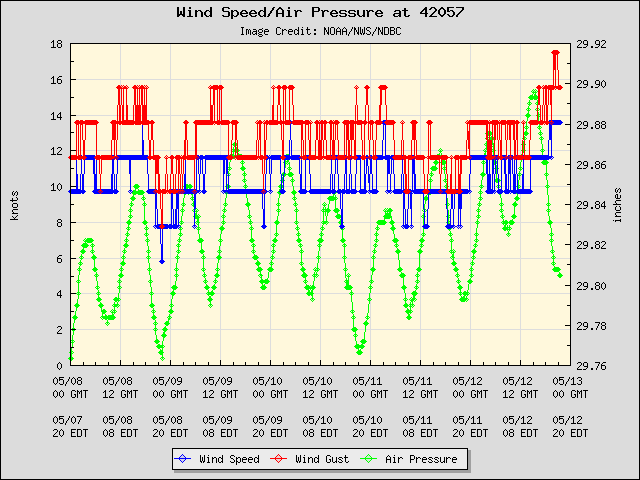
Buoy 42057 at 16.8N 81.5W (about 100 miles ESE of the center) has been reporting sustained winds over 20 kt the past 3 hours, with 1-minute sustained winds of 27 kt and a peak gust of 35 kt in the past hour.
0 likes
-
cycloneye

- Admin

- Posts: 149670
- Age: 69
- Joined: Thu Oct 10, 2002 10:54 am
- Location: San Juan, Puerto Rico
Re: ATL : INVEST 99L - Discussion
jconsor wrote:The recon hasn't looked at the east side of the storm at all, which is clearly the stronger side, so it's too preliminary to make a determination yet whether this qualifies as a TD.
Buoy 42057 at 16.8N 81.5W (about 100 miles ESE of the center) has been reporting sustained winds over 20 kt the past 3 hours, with 1-minute sustained winds of 27 kt and a peak gust of 35 kt in the past hour.
Now that they closed the circulation,they may do that.
0 likes
Visit the Caribbean-Central America Weather Thread where you can find at first post web cams,radars
and observations from Caribbean basin members Click Here
and observations from Caribbean basin members Click Here
-
SouthDadeFish
- Professional-Met
- Posts: 2836
- Joined: Thu Sep 23, 2010 2:54 pm
- Location: Miami, FL
- Contact:
-
wxman57
- Moderator-Pro Met
- Posts: 23175
- Age: 68
- Joined: Sat Jun 21, 2003 8:06 pm
- Location: Houston, TX (southwest)
Re: ATL : INVEST 99L - Discussion
jconsor wrote:The recon hasn't looked at the east side of 99L at all, which is clearly the stronger side, so it's too preliminary to make a determination yet whether this qualifies as a TD.
Buoy 42057 at 16.8N 81.5W (about 100 miles ESE of the center) has been reporting sustained winds over 20 kt the past 3 hours, with 1-minute sustained winds of 27 kt and a peak gust of 35 kt in the past hour.
http://www.ndbc.noaa.gov/plot_wind_pres ... _label=EDT
I'm thinking of the requirement for significant convection near the center to upgrade. Not much convection there yet. It's clearly weaker than Paula was 60 hours before the NHC upgraded it. But maybe they'll pull the trigger earlier with this one?
0 likes
-
jconsor
- Professional-Met
- Posts: 581
- Joined: Mon Jun 30, 2008 9:31 pm
- Location: Jerusalem, Israel
- Contact:
Re: ATL : INVEST 99L - Discussion
I definitely agree that 99L's convection is rather paltry and tops have warmed in the past 12 hours. However, the fact that buoy 42057 has seen winds around 25 kt with gusts of 30-35 kt the past 3 hours with convective bands overhead suggests the convection is relatively efficient at transporting higher winds to the surface. Winds were only around 10 kt at buoy 42057 before the convective bands began moving in.
wxman57 wrote:I'm thinking of the requirement for significant convection near the center to upgrade. Not much convection there yet. It's clearly weaker than Paula was 60 hours before the NHC upgraded it. But maybe they'll pull the trigger earlier with this one?
0 likes
-
SouthDadeFish
- Professional-Met
- Posts: 2836
- Joined: Thu Sep 23, 2010 2:54 pm
- Location: Miami, FL
- Contact:
They didn't pull the trigger with Paula IMO because they LOVE to have recon data support classification and will often wait until recon flies out there even if it already looks very much like a tropical depression. Since recon already flew out there, I wouldn't be surprised to see a TD, especially since they sent out the vortex message.
0 likes

-
HURAKAN

- Professional-Met
- Posts: 46084
- Age: 39
- Joined: Thu May 20, 2004 4:34 pm
- Location: Key West, FL
- Contact:
Re: ATL : INVEST 99L - Discussion
If the NHC believes that the system is likely to intensify from now on, I wouldn't be surprised to see a TD at 5 pm.
0 likes

-
Blown Away

- S2K Supporter

- Posts: 10253
- Joined: Wed May 26, 2004 6:17 am
Re: ATL : INVEST 99L - Discussion
Interesting the 18z TVCN consensus loops 99L and then turns it NW, clipping the NE Yucatan, the heads towards the GOMER with very little land interaction!!
0 likes
Hurricane Eye Experience: David 79, Irene 99, Frances 04, Jeanne 04, Wilma 05… Hurricane Brush Experience: Andrew 92, Erin 95, Floyd 99, Matthew 16, Irma 17, Ian 22, Nicole 22…
-
wxman57
- Moderator-Pro Met
- Posts: 23175
- Age: 68
- Joined: Sat Jun 21, 2003 8:06 pm
- Location: Houston, TX (southwest)
Re: ATL : INVEST 99L - Discussion
Blown Away wrote:Interesting the 18z TVCN consensus loops 99L and then turns it NW, clipping the NE Yucatan, the heads towards the GOMER with very little land interaction!!
That's because it's incorporating the GFDL track, the right outlier in the models. Most other models take it south then west, passing over or near Honduras. GFDL takes it northeast then west (just south of Cuba). HWRF into northern Belize. Consensus is right in between the various scenarios toward the northern Yucatan. Simple as that.
0 likes
-
cycloneye
- Admin
- Posts: 149670
- Age: 69
- Joined: Thu Oct 10, 2002 10:54 am
- Location: San Juan, Puerto Rico
Re: ATL : INVEST 99L - Discussion
ATCF updated a new position.
AL, 99, 2010101918, , BEST, 0, 174N, 834W, 30, 1008, LO
ftp://ftp.tpc.ncep.noaa.gov/atcf/tcweb/ ... 010.invest
AL, 99, 2010101918, , BEST, 0, 174N, 834W, 30, 1008, LO
ftp://ftp.tpc.ncep.noaa.gov/atcf/tcweb/ ... 010.invest
0 likes
Visit the Caribbean-Central America Weather Thread where you can find at first post web cams,radars
and observations from Caribbean basin members Click Here
and observations from Caribbean basin members Click Here
-
wxman57
- Moderator-Pro Met
- Posts: 23175
- Age: 68
- Joined: Sat Jun 21, 2003 8:06 pm
- Location: Houston, TX (southwest)
Re: ATL : INVEST 99L - Discussion
Models just initialized as "Disturbance Invest (AL992010) at 18Z. 17.4N/83.4W with 30 kts at 00hrs. No hint of an upgrade there.
0 likes
-
Blown Away
- S2K Supporter
- Posts: 10253
- Joined: Wed May 26, 2004 6:17 am
Re: ATL : INVEST 99L - Discussion
wxman57 wrote:Blown Away wrote:Interesting the 18z TVCN consensus loops 99L and then turns it NW, clipping the NE Yucatan, the heads towards the GOMER with very little land interaction!!
That's because it's incorporating the GFDL track, the right outlier in the models. Most other models take it south then west, passing over or near Honduras. GFDL takes it northeast then west (just south of Cuba). HWRF into northern Belize. Consensus is right in between the various scenarios toward the northern Yucatan. Simple as that.
NHC generally splits the middle also, correct? So if 99L were classified we might see a track close to the TVCN consensus. Earlier TVCN runs buried 99L into CA, so maybe there is a change in the pattern for now?
0 likes
Hurricane Eye Experience: David 79, Irene 99, Frances 04, Jeanne 04, Wilma 05… Hurricane Brush Experience: Andrew 92, Erin 95, Floyd 99, Matthew 16, Irma 17, Ian 22, Nicole 22…
Re: ATL : INVEST 99L - Discussion
A couple of days ago I posted the climo stats for mid to late Oct. W. Caribbean TC's that formed at 15N or further south/77.5W or further west, which is where Richard had earlier been progged to form by the gfs on a number of runs. Those stats suggested about a 40% chance for a U.S. hit as well as ~40% chance of an ending in C.A./MX. They also suggested only ~20% chance for a miss of the US to the east.
However, it nows appears likely that Richard will form much further north: within the 15-20N, 80-85W box. What does that say about the various scenario probablities? For those who would like some U.S. action, this is good news (as one might expect due to the much closer start point to the U.S.) because the % of these that hit the U.S. was higher while the % of those that ended their tracks in/near C.A./MX was smaller.
Breakdown for the 1851-2009 mid to late OCT W. Caribbean TC's:
- 9 (64%) hit the U.S. with 6 of these (43% of the total) hitting S or C FL (all as 'canes)
- 3 (21%) missed the U.S. to the east
- 2 (14%) hit Belize (both at no stronger than TS strength)
If I lived in C or S FL, I'd pay extra attention for a potential threat.
For the nine that hit the U.S., the average # of days from birth as a TD+ til the hit was ~4.5. The # of days were as follows:
7, 7, 5, 5, 5, 3, 3, 3, 2
0 likes
Personal Forecast Disclaimer:
The posts in this forum are NOT official forecasts and should not be used as such. They are just the opinion of the poster and may or may not be backed by sound meteorological data. They are NOT endorsed by any professional institution or storm2k.org. For official information, please refer to the NHC and NWS products.
The posts in this forum are NOT official forecasts and should not be used as such. They are just the opinion of the poster and may or may not be backed by sound meteorological data. They are NOT endorsed by any professional institution or storm2k.org. For official information, please refer to the NHC and NWS products.
-
cycloneye
- Admin
- Posts: 149670
- Age: 69
- Joined: Thu Oct 10, 2002 10:54 am
- Location: San Juan, Puerto Rico
Re: ATL : INVEST 99L - Discussion
Decoded VDM:
Product: Air Force Vortex Message (URNT12 KNHC)
Transmitted: 19th day of the month at 19:37Z
Corrected: This observation corrected a previous observation.
Aircraft: Air Force Aircraft (Last 3 digits of the tail number are 303)
Mission Purpose: Investigate eight suspect area (flight in the North Atlantic basin)
Mission Number: 1
Observation Number: 13
A. Time of Center Fix: 19th day of the month at 19:09:00Z
B. Center Fix Coordinates: 17°23'N 83°29'W (17.3833N 83.4833W) (View map)
B. Center Fix Location: 191 miles (308 km) to the SW (226°) from George Town, Cayman Islands (GBR).
C. Minimum Height at Standard Level: Not Available
D. Estimated (by SFMR or visually) Maximum Surface Wind: 27kts (~ 31.1mph)
E. Location of the Estimated Maximum Surface Wind: 20 nautical miles (23 statute miles) to the NNW (347°) of center fix
F. Maximum Flight Level Wind Inbound: From 112° at 20kts (From the ESE at ~ 23.0mph)
G. Location of Maximum Flight Level Wind Inbound: 21 nautical miles (24 statute miles) to the NNW (347°) of center fix
H. Minimum Sea Level Pressure: 1009mb (29.80 inHg) - Extrapolated
I. Maximum Flight Level Temp & Pressure Altitude Outside Eye: 22°C (72°F) at a pressure alt. of 303m (994ft)
J. Maximum Flight Level Temp & Pressure Altitude Inside Eye: 23°C (73°F) at a pressure alt. of 302m (991ft)
K. Dewpoint Temp (collected at same location as temp inside eye): 22°C (72°F)
K. Sea Surface Temp (collected at same location as temp inside eye): Not Available
L. Eye Character: Not Available
M. Eye Shape: Not Available
N. Fix Determined By: Penetration, Wind and Pressure
N. Fix Level: 1,500 feet
O. Navigation Fix Accuracy: 0.02 nautical miles
O. Meteorological Accuracy: 5 nautical miles
Remarks Section - Remarks That Were Decoded...
Maximum Flight Level Wind: 20kts (~ 23.0mph) in the north quadrant at 18:59:30Z
Maximum Flight Level Wind Outbound: 21kts (~ 24.2mph) in the southeast quadrant at 19:15:30Z
Sea Level Pressure Extrapolation From: Below 1,500 feet
Remarks Section - Additional Remarks...
BEST WINDSHIFT CENTER WAS AT 19:05:50Z AT 17 31N 83 35W
0 likes
Visit the Caribbean-Central America Weather Thread where you can find at first post web cams,radars
and observations from Caribbean basin members Click Here
and observations from Caribbean basin members Click Here
Who is online
Users browsing this forum: No registered users and 113 guests