Wow! I popped up the satellite and got my surprise of the morning. Where is it??
Yes KWT...development appears to be a ways off.
ATL : INVEST 90L - DISCUSSION
Moderator: S2k Moderators

Re: ATL : INVEST 90L - DISCUSSION
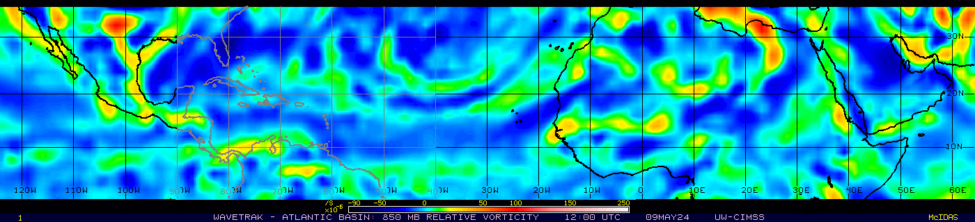
Maybe near 32 W 8.5N? Watch the loop and you can easily spot the wave axis.Where is it??
Last edited by Nimbus on Fri Jul 30, 2010 5:51 am, edited 1 time in total.
0 likes

-
Blown Away

- S2K Supporter

- Posts: 10253
- Joined: Wed May 26, 2004 6:17 am
Re: ATL : INVEST 90L - DISCUSSION
Convection consolidating and I see a nice rotation developing. Going to be a slow go but I think we will eventually see Colin from this area.
0 likes
Hurricane Eye Experience: David 79, Irene 99, Frances 04, Jeanne 04, Wilma 05… Hurricane Brush Experience: Andrew 92, Erin 95, Floyd 99, Matthew 16, Irma 17, Ian 22, Nicole 22…
-
Vortmax1
- Category 1

- Posts: 360
- Joined: Wed Jul 07, 2010 11:35 pm
- Location: Port Salerno, FL
- Contact:
It's going to need to really start pulsing then to make Cat 3 in 120 hours like the LGEM forecasts!
http://euler.atmos.colostate.edu/~vigh/ ... early1.png
http://euler.atmos.colostate.edu/~vigh/ ... early1.png
0 likes
-
Florida1118
Re: ATL : INVEST 90L - DISCUSSION
A SMALL AREA OF DISTURBED WEATHER LOCATED OVER THE EASTERN ATLANTIC
OCEAN ABOUT 700 MILES SOUTHWEST OF THE CAPE VERDE ISLANDS IS
SHOWING NO SIGNS OF DEVELOPMENT AT THIS TIME. HOWEVER...A TROPICAL
WAVE THAT JUST MOVED OFF THE COAST OF AFRICA IS PRODUCING A LARGE
AREA OF SHOWERS AND THUNDERSTORMS...AND THESE TWO SYSTEMS COULD
BEGIN TO INTERACT IN A COUPLE OF DAYS. THERE IS A LOW CHANCE...20
PERCENT...OF TROPICAL CYCLONE FORMATION IN THIS AREA DURING THE
NEXT 48 HOURS.
0 likes
-
wzrgirl1

- S2K Supporter
- Posts: 1360
- Joined: Sat Sep 04, 2004 6:44 am
- Location: Pembroke Pines, Florida
Re: ATL : INVEST 90L - DISCUSSION
My curiosity lies with the synoptics and where that high pressure will be in the 10 day time frame. Any weakness at all might steer in toward the Carolinas depending on the latitude of the storm. I always think of Andrew and how they knew days ahead of time that the high pressure would stay strong. I will be watching this one very closely.
0 likes
-
Aric Dunn
- Category 5

- Posts: 21238
- Age: 43
- Joined: Sun Sep 19, 2004 9:58 pm
- Location: Ready for the Chase.
- Contact:
Re:
Vortmax1 wrote:AND THESE TWO SYSTEMS COULD
BEGIN TO INTERACT IN A COUPLE OF DAYS.
Oh boy! Let the fun begin!
That scenario was in my thoughts earlier this morning. Interesting.
yeah we knew that was coming..
0 likes


-
srainhoutx

- S2K Supporter
- Posts: 6919
- Age: 68
- Joined: Sun Jan 14, 2007 11:34 am
- Location: Haywood County, NC
- Contact:
Re: ATL : INVEST 90L - DISCUSSION
A bit wider view of the 'players'...

0 likes
Carla/Alicia/Jerry(In The Eye)/Michelle/Charley/Ivan/Dennis/Katrina/Rita/Wilma/Ike/Harvey
Member: National Weather Association
Wx Infinity Forums
http://wxinfinity.com/index.php
Facebook.com/WeatherInfinity
Twitter @WeatherInfinity
Member: National Weather Association
Wx Infinity Forums
http://wxinfinity.com/index.php
Facebook.com/WeatherInfinity
Twitter @WeatherInfinity
-
Blown Away
- S2K Supporter
- Posts: 10253
- Joined: Wed May 26, 2004 6:17 am
Re: ATL : INVEST 90L - DISCUSSION

Now that's one big easter egg!
My kids would love it!
0 likes
Hurricane Eye Experience: David 79, Irene 99, Frances 04, Jeanne 04, Wilma 05… Hurricane Brush Experience: Andrew 92, Erin 95, Floyd 99, Matthew 16, Irma 17, Ian 22, Nicole 22…

-
hurricaneCW
- Category 5
- Posts: 1799
- Joined: Wed Mar 03, 2010 6:20 am
- Location: Toms River, NJ
Re: ATL : INVEST 90L - DISCUSSION
So the waves are going to merge. If they do, what would happen.
0 likes

-
StormClouds63
- Category 2

- Posts: 583
- Age: 62
- Joined: Tue May 13, 2008 11:56 am
- Location: Southwest Louisiana
ATL: INVEST 90L - MODELS
Wx_Warrior wrote:That's a new one....ha....this little diddy has been all over the map.
Wx_Warrior:
Your avatar ... yet another change I see!
Our ole' buddy Joe, who returned a few weeks ago, is now is holding a sign for for the European Centre for Medium-Range Weather Forecasts (ECMWF).
So, Wx_Warrior: Does 90L develop into a named system? Landfalling system or fish? Atlantic or Caribbean?
Finally, is the #3 storm this year pronounced "Colon" or "Cawlin"? I've watched a couple of broadcasts and it has been pronounced both ways. So, which is it?
0 likes
-
StormClouds63
- Category 2
- Posts: 583
- Age: 62
- Joined: Tue May 13, 2008 11:56 am
- Location: Southwest Louisiana
Re: ATL : INVEST 90L - DISCUSSION
Another long wait likely ahead to see if a system is going to develop or not. Might not know for sure until Sunday or Monday. The scenario with the two waves "merging" is a new one to me, so that may take even more time for the one system to then consolidate.
If it survives, then the fish vs. non-fish arguments will begin. If it weren't so hot outside, I really would be "fishing."
If it survives, then the fish vs. non-fish arguments will begin. If it weren't so hot outside, I really would be "fishing."
0 likes
-
Aric Dunn
- Category 5
- Posts: 21238
- Age: 43
- Joined: Sun Sep 19, 2004 9:58 pm
- Location: Ready for the Chase.
- Contact:
Re: ATL : INVEST 90L - DISCUSSION
StormClouds63 wrote:Another long wait likely ahead to see if a system is going to develop or not. Might not know for sure until Sunday or Monday. The scenario with the two waves "merging" is a new one to me, so that may take even more time for the one system to then consolidate.
If it survives, then the fish vs. non-fish arguments will begin. If it weren't so hot outside, I really would be "fishing."
If the idea is somewhat new to you there was some good discussions about it at the beginning of this thread but more so down in the thread "blob at 30w" this merging was expected but your right the time it takes for such interactions to occur take various times depending many factors. On a side note and mentioned sometime ago was that since the wave off africa is quite a bit larger then the original 90L, it will likely be the dominate low. both seem to have decent low level turning, however the wave off africa has a much more expansive wind field. sunday or monday is a good bet, but we should really start to see the systems begin to interact more later tonight and tomorrow with some sort of more distinct surface feature beginning to develop on sunday sometime. Any upgrade wont likely happen till monday ( if at all). As for track... as long as it stays weak it will stay on a more west track and once it gets a little more organized a wnw track should take place. the GFDL and HWRF are just way too fast and this can easily be seen when you look at the current motion of the systems.... they are moving slow. the intensity is of course tricky but once a well defined center becomes established strengthening to a hurricane pretty quickly is very possible as all forecast call for low shear and good moisture envelope. all in all we get to wait as you said... lol
0 likes
Note: If I make a post that is brief. Please refer back to previous posts for the analysis or reasoning. I do not re-write/qoute what my initial post said each time.
If there is nothing before... then just ask
Space & Atmospheric Physicist, Embry-Riddle Aeronautical University,
I believe the sky is falling...
If there is nothing before... then just ask
Space & Atmospheric Physicist, Embry-Riddle Aeronautical University,
I believe the sky is falling...
Who is online
Users browsing this forum: No registered users and 119 guests