ATL: Remnants of PAULA - Discussion
Moderator: S2k Moderators


It doesn't look as symmetrical as before and elongated to the north/northeast. Perhaps this view is what some people are stating for shear coming into play. Storms with that kind of look tends to speed up (wxman I think said speed might pick up) being caught into a trough and I can see where this is coming from.
0 likes
The above post and any post by Ntxw is NOT an official forecast and should not be used as such. It is just the opinion of the poster and may or may not be backed by sound meteorological data. It is NOT endorsed by any professional institution including Storm2k. For official information, please refer to NWS products.
Help support Storm2K!


-
SouthDadeFish

- Professional-Met

- Posts: 2836
- Joined: Thu Sep 23, 2010 2:54 pm
- Location: Miami, FL
- Contact:
-
Shuriken
-
SouthDadeFish
- Professional-Met
- Posts: 2836
- Joined: Thu Sep 23, 2010 2:54 pm
- Location: Miami, FL
- Contact:
-
Battlebrick
- Tropical Storm

- Posts: 177
- Joined: Thu Sep 02, 2010 9:55 pm
Re: ATL: PAULA - Hurricane - Discussion
I'd like to point out that everyone was saying how Paula was weakening this morning and it should be downgraded to a TS when in reality it was going through RI. It seems like the same situation this time.
0 likes
Lim_Fao on IRC.
The following post is NOT an official forecast and should not be used as such. It is just the opinion of the poster and may or may not be backed by sound meteorological data. It is NOT endorsed by any professional institution including storm2k.org. For Official Information please refer to the NHC and NWS products.
The following post is NOT an official forecast and should not be used as such. It is just the opinion of the poster and may or may not be backed by sound meteorological data. It is NOT endorsed by any professional institution including storm2k.org. For Official Information please refer to the NHC and NWS products.
-
brunota2003

- S2K Supporter

- Posts: 9476
- Age: 35
- Joined: Sat Jul 30, 2005 9:56 pm
- Location: Stanton, KY...formerly Havelock, NC
- Contact:
Re: ATL: PAULA - Tropical Storm - Discussion
brunota2003 wrote:latitude_20 wrote:So looking at the purple, which indicates the top of the IR spectrum, would this be a tip-off to possible RI?
http://www.ssd.noaa.gov/goes/flt/t2/jsl-l.jpgThe posts in this forum are NOT official forecast and should not be used as such. They are just the opinion of the poster and may or may not be backed by sound meteorological data. They are NOT endorsed by any professional institution or storm2k.org. For official information, please refer to the NHC and NWS products.
Depends on where the center is...But, assuming the purple is wrapping into the center, then yes I would say that IR will be likely occurring within the next 12 hours. The fact that part of it is overland will limit the IR some, but I could see the system getting to Cat 2 or 3 by tomorrow afternoon.
Was posted at 7:52 pm last night...not too shabby of a guess, since Paula did RI and became a Cat 2 before leveling off very early this afternoon.
0 likes
-
SouthDadeFish
- Professional-Met
- Posts: 2836
- Joined: Thu Sep 23, 2010 2:54 pm
- Location: Miami, FL
- Contact:
Re: ATL: PAULA - Hurricane - Discussion
Battlebrick wrote:I'd like to point out that everyone was saying how Paula was weakening this morning and it should be downgraded to a TS when in reality it was going through RI. It seems like the same situation this time.
We'll see. Conditions are not as favorable as this morning.
0 likes
Re: ATL: PAULA - Hurricane - Discussion
Battlebrick wrote:I'd like to point out that everyone was saying how Paula was weakening this morning and it should be downgraded to a TS when in reality it was going through RI. It seems like the same situation this time.
The difference is that Paula is further north now vs then and the environment is not favorable and doesn't look to be. As long as she remains below the Antilles her odds are better.
0 likes
The above post and any post by Ntxw is NOT an official forecast and should not be used as such. It is just the opinion of the poster and may or may not be backed by sound meteorological data. It is NOT endorsed by any professional institution including Storm2k. For official information, please refer to NWS products.
Help support Storm2K!
Help support Storm2K!
-
brunota2003
- S2K Supporter
- Posts: 9476
- Age: 35
- Joined: Sat Jul 30, 2005 9:56 pm
- Location: Stanton, KY...formerly Havelock, NC
- Contact:


Re: ATL: PAULA - Hurricane - Discussion
Any thoughts on whether the cone might shift at 11pm. I have been trying to catch up. Seems like quite a hard right turn starting tomorrow at 1pm per the last cone.
0 likes
-
SouthDadeFish
- Professional-Met
- Posts: 2836
- Joined: Thu Sep 23, 2010 2:54 pm
- Location: Miami, FL
- Contact:

-
Evil Jeremy

- S2K Supporter
- Posts: 5463
- Age: 32
- Joined: Mon Apr 10, 2006 2:10 pm
- Location: Los Angeles, CA
Re: ATL: PAULA - Hurricane - Discussion
blp wrote:Any thoughts on whether the cone might shift at 11pm. I have been trying to catch up. Seems like quite a hard right turn starting tomorrow at 1pm per the last cone.
I highly doubt the turn itself will be that sharp. Anyways, I think the cone will be moved up north. Perhaps not solely on the storm's own merits, but if more of SFL can be moved into the cone, it could raise awareness about a possible threat being on its way. I think the cone's center will skim Cuba's north coast.
0 likes
Frances 04 / Jeanne 04 / Katrina 05 / Wilma 05 / Fay 08 / Debby 12 / Andrea 13 / Colin 16 / Hermine 16 / Matthew 16 / Irma 17

Re: ATL: PAULA - Hurricane - Discussion
Evil Jeremy wrote:blp wrote:Any thoughts on whether the cone might shift at 11pm. I have been trying to catch up. Seems like quite a hard right turn starting tomorrow at 1pm per the last cone.
I highly doubt the turn itself will be that sharp. Anyways, I think the cone will be moved up north. Perhaps not solely on the storm's own merits, but if more of SFL can be moved into the cone, it could raise awareness about a possible threat being on its way. I think the cone's center will skim Cuba's north coast.
I think the NHC is right with the hard right turn look at the water vapor. notice the shortwave presing SE towards Florida which would force Paula ENE along the Cuban coatline.
http://www.ssd.noaa.gov/goes/east/watl/flash-wv.html
0 likes
-
Florida1118
Re: ATL: PAULA - Hurricane - Discussion
Evil Jeremy wrote:blp wrote:Any thoughts on whether the cone might shift at 11pm. I have been trying to catch up. Seems like quite a hard right turn starting tomorrow at 1pm per the last cone.
I highly doubt the turn itself will be that sharp. Anyways, I think the cone will be moved up north. Perhaps not solely on the storm's own merits, but if more of SFL can be moved into the cone, it could raise awareness about a possible threat being on its way. I think the cone's center will skim Cuba's north coast.
Are you talking about the 3day cone or 5day? Because if the 5day i on the very coast of N Cuba, most of the peninsula would be covered by cone.
0 likes
-
SouthDadeFish
- Professional-Met
- Posts: 2836
- Joined: Thu Sep 23, 2010 2:54 pm
- Location: Miami, FL
- Contact:

Re: ATL: PAULA - Hurricane - Discussion
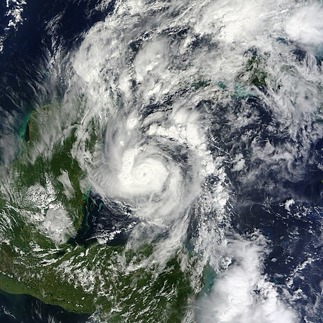
Now I see what some of you said about erosion on the southern side, it may not be a rapid weakening but certainly it looks like it peaked.
0 likes
Re: ATL: PAULA - Hurricane - Discussion
The turn could be starting. Or it could just be a quirk in the CDO.
Last edited by Sanibel on Tue Oct 12, 2010 9:23 pm, edited 1 time in total.
0 likes
Who is online
Users browsing this forum: No registered users and 178 guests